Jefferson County lies in northeastern Kansas, where Oskaloosa serves as the county seat while Valley Falls is the largest city shown on the map. Perry, McLouth, Meriden, and Nortonville provide additional settlement anchors around a landscape dominated by Perry Lake and the Kansas River lowlands. U.S. 24 crosses the southern county, U.S. 59 passes through the Oskaloosa corridor, and several state highways connect the smaller towns. High-resolution JPG versions of the maps can be downloaded together from the ZIP box below. High-resolution map files are available for download in the section below.
Perry Lake is the county’s most striking physical feature. The reservoir occupies a long, branching valley on the Delaware River, with Slough Creek, Rock Creek, and smaller tributaries entering from surrounding hills. The Kansas River follows the southern boundary, while Walnut Creek, Crooked Creek, Prairie Creek, and other drainages cut through the northern and eastern uplands. Elevation ranges from about 248 to 364 meters with a mean near 310 meters.
The Kansas Historical Society records Jefferson County as one of the counties created in 1855. Ozawkie served as the early county seat before Oskaloosa won the seat in an 1858 election and retained it after another vote in 1864. That history helps explain why Oskaloosa remains the administrative center even though Valley Falls is larger on the city distribution map.
Table of Contents
Oskaloosa anchors the road network
Oskaloosa sits slightly east of the county center and is the easiest place to begin when reading the general map. U.S. 59 runs north and south through the wider Oskaloosa corridor, while K-16 heads east toward McLouth. South of Oskaloosa, U.S. 24 provides the principal east-west route near Perry and the Kansas River valley.
Valley Falls lies to the northwest and connects with the K-4 corridor. Meriden marks the western side, Perry sits near U.S. 24 in the south, and Nortonville is close to the northern boundary. Winchester provides a northeastern reference. Because Perry Lake occupies so much of the central-southern county, roads bend around the reservoir rather than following a simple rectangular pattern.
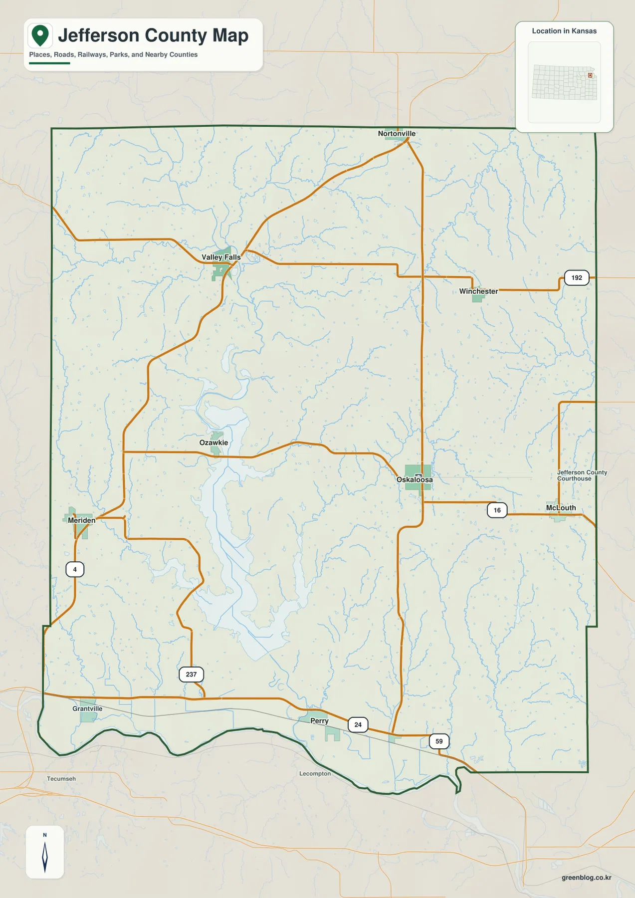
The reservoir also creates a practical separation between communities on opposite sides of the lake. K-237 and local roads serve access near the lake, while U.S. 24 carries traffic along the southern corridor. The map is intended for county-scale orientation rather than live navigation, so current construction, flooding, winter weather, and local road conditions should be checked separately.
Valley Falls is largest, while Oskaloosa remains the county seat
The city distribution map ranks Valley Falls first, Oskaloosa second, Perry third, McLouth fourth, Meriden fifth, and Nortonville sixth. The displayed values are 1,382 for Valley Falls, 1,113 for Oskaloosa, 1,069 for Perry, 864 for McLouth, 716 for Meriden, and 715 for Nortonville. These figures belong to the source used for the map and may differ from later estimates.
The more durable geographic lesson is the separation of roles. Valley Falls is the largest city shown, but Oskaloosa is the county seat and administrative center. Perry organizes the southern U.S. 24 corridor, McLouth provides an eastern town reference, Meriden marks the west, and Nortonville helps orient the northern edge.
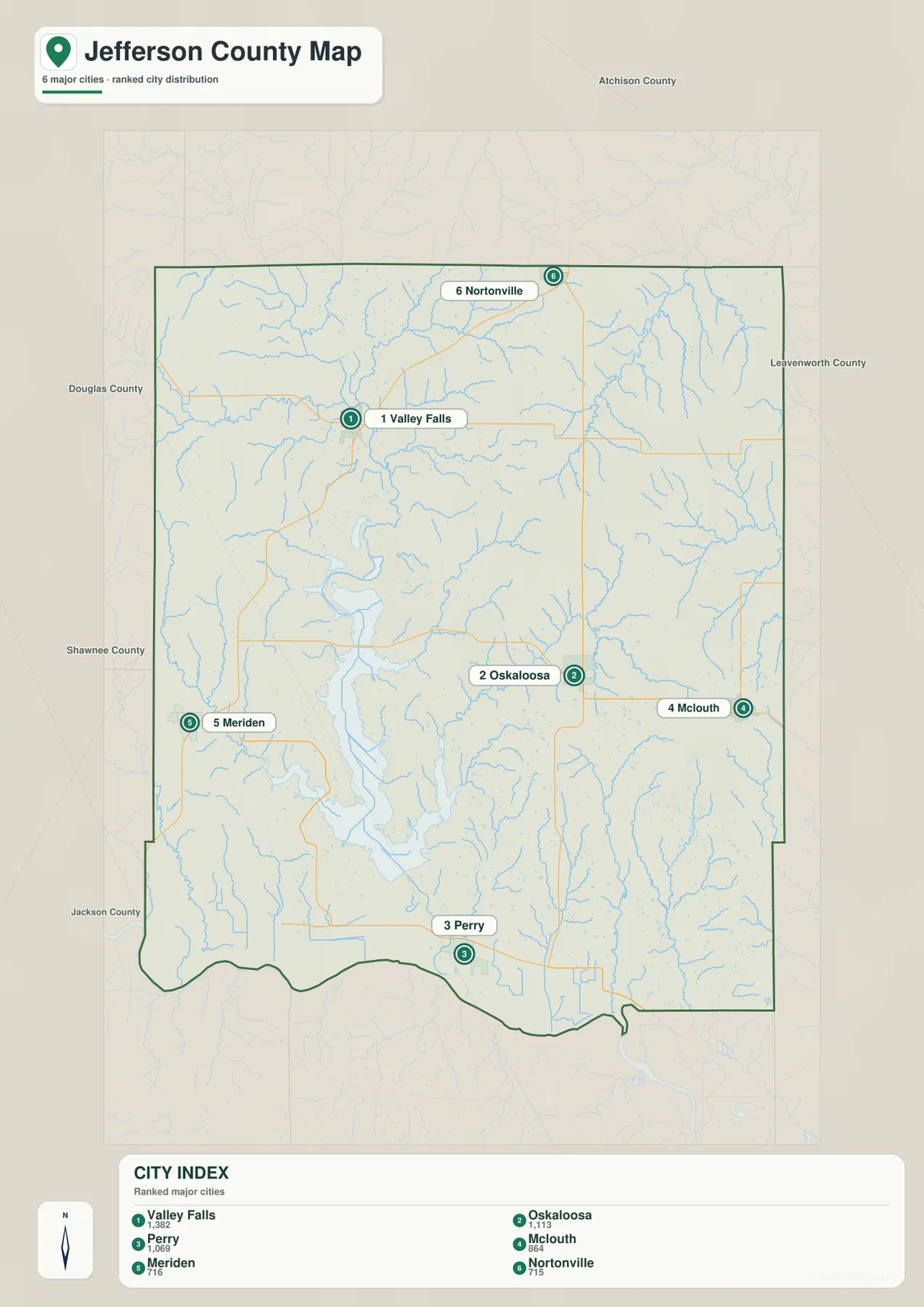
The Kansas Historical Society explains that Ozawkie held the county-seat role first, but Oskaloosa won the seat in 1858 and kept it after another election in 1864. The modern city map therefore shows two different kinds of importance: population concentration at Valley Falls and county government at Oskaloosa.
Perry Lake and the Delaware River dominate the water map
Perry Lake is the largest water feature in Jefferson County. The U.S. Army Corps of Engineers operates Perry Dam on the Delaware River and manages the reservoir for flood-risk reduction, water quality, water supply, wildlife conservation, recreation, and other authorized purposes. On the map, the reservoir fills a long branching valley that reaches far into the central part of the county.
Slough Creek approaches the lake from the east, while Rock Creek and other tributaries enter from the west and southwest. Walnut Creek crosses the northern uplands, Crooked Creek cuts through the northeast, and Prairie Creek drains part of the eastern county. These smaller valleys make the terrain much more dissected than the road map alone suggests.
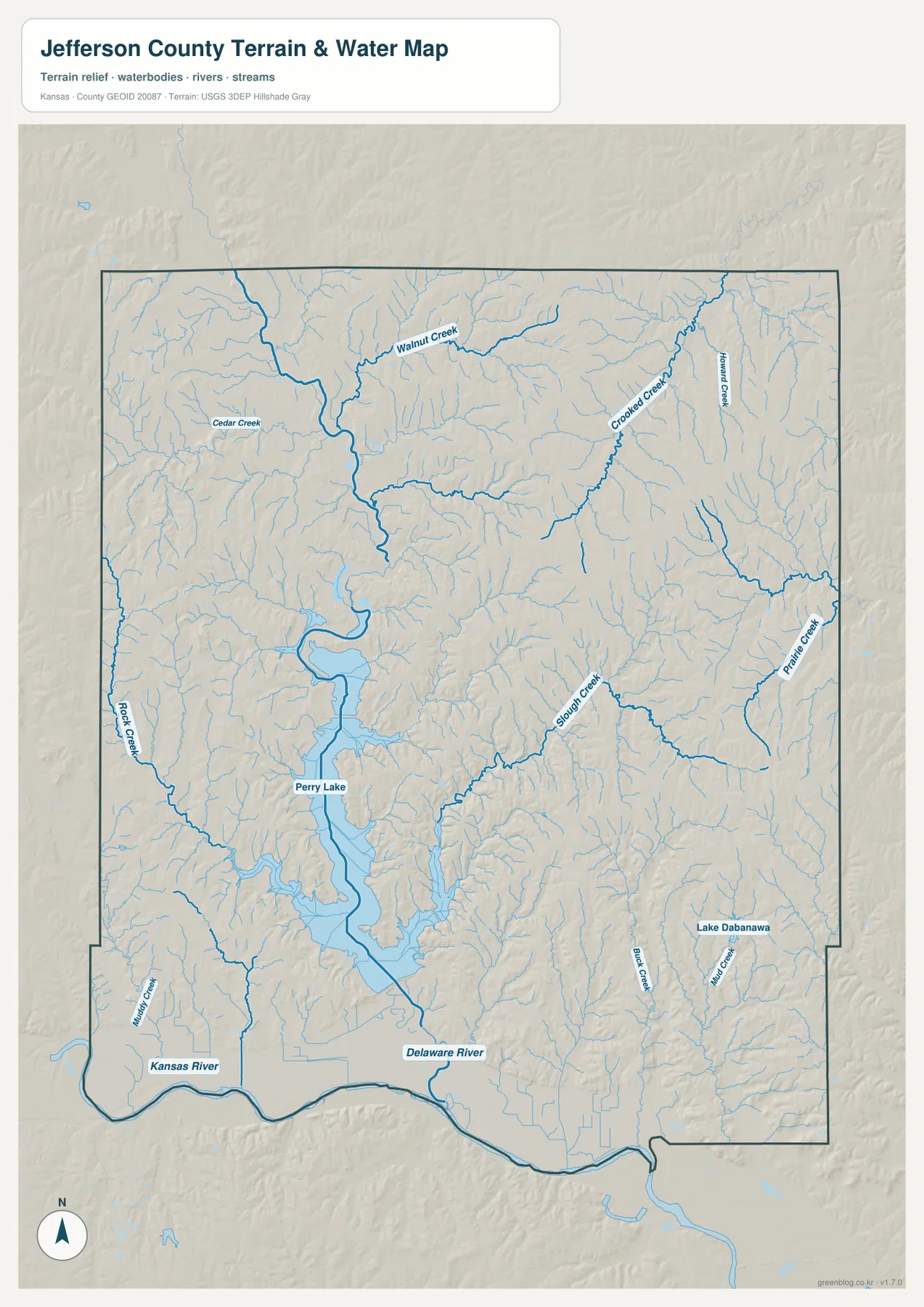
Below Perry Dam, the Delaware River continues south toward the Kansas River. The Kansas River itself forms a broad low corridor along the county’s southern edge. This map is a geographic reference rather than a live water-level or flood product, so current reservoir conditions, river stages, and flood information should be checked with the U.S. Army Corps of Engineers or USGS.
Elevation drops from rolling uplands to the Kansas River valley
The elevation map shows an actual county range of approximately 248 to 364 meters and a mean elevation near 310 meters. The lowest green terrain follows the Kansas River valley and the Perry Lake–Delaware River system. Higher brown and orange ridges are especially visible in the east and northeast, with additional uplands in the northwest.
Perry Lake fills a deeply incised valley, so its shoreline has many narrow arms between surrounding ridges. Tributaries create green fingers that extend into the higher terrain on both sides of the reservoir. Crooked Creek and Prairie Creek also cut long lower corridors through the eastern hills, while the southern Kansas River valley forms the broadest continuous lowland.
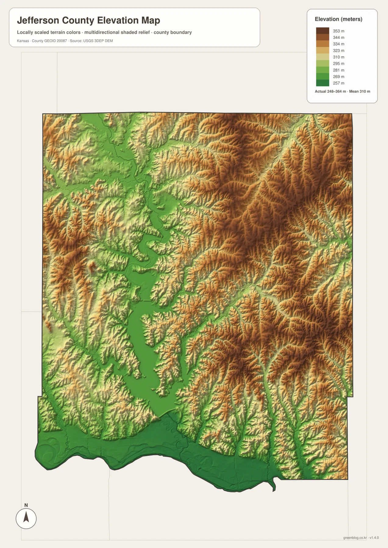
This elevation surface is intended for county-scale comparison rather than survey-grade measurement. It should not be used to establish exact parcel elevations, design drainage, or replace engineering and legal survey data. Its main value is visual context: the low reservoir and river valleys stand out clearly against the surrounding rolling uplands.
Why Perry Lake matters beyond its size on the map
Perry Lake occupies enough of the county to influence both travel and local land use. The U.S. Army Corps of Engineers operates the reservoir as part of a broader Kansas River Basin water-management system. Flood-risk reduction is one of its major purposes, and the lake also supports water supply, water quality, wildlife habitat, and recreation.
Roads and communities around the reservoir respond to the shape of the valley. Ozawkie lies on the western side of the lake area, while Perry is farther south near U.S. 24. Crossing from one side of the lake to the other often requires following roads around long coves and ridges rather than taking a direct line.
The lake is also a major recreation destination, but conditions and facility schedules change. Visitors planning boating, camping, trail use, or shoreline access should check the current Perry Lake information from the U.S. Army Corps of Engineers before traveling.
Oskaloosa, Valley Falls, and the county’s territorial-era history
Jefferson County was established in 1855 and named for Thomas Jefferson. The Kansas Historical Society describes the county as an important setting during the territorial struggle between free-state and proslavery settlers. Valley Falls, then known as Grasshopper Falls, experienced violence during that period.
Ozawkie served as the first county seat, but Oskaloosa won the seat in an 1858 election. A later vote in 1864 confirmed Oskaloosa again. That decision shaped the administrative geography still visible today, with county government centered at Oskaloosa even though Valley Falls has the larger population shown on the city map.
The county’s history extends well before modern towns. Kansas Historical Society sources note Kaw and Delaware peoples in the region and describe Daniel Morgan Boone’s presence in the 1820s as part of a federal agricultural program. Natural corridors such as the Kansas River and Delaware River therefore connect many different periods of settlement and travel.
Using the maps for printing, study, and county orientation
For road orientation, start with Oskaloosa and U.S. 59, then connect K-16 toward McLouth and U.S. 24 toward Perry. Valley Falls in the northwest and Meriden in the west provide additional references. For physical geography, locate Perry Lake first, then follow the Delaware River south toward the Kansas River and compare Slough Creek, Rock Creek, and the eastern tributaries.
The high-resolution JPG files in the ZIP are better suited than the reduced web previews for printing, classroom projects, local-history materials, and close inspection of labels. They are useful for county overviews and regional comparison, but current roads, live reservoir and river conditions, parcel boundaries, and exact elevations should always be checked against the latest authoritative sources when those details matter.
Frequently Asked Questions
Where is Oskaloosa on the Jefferson County map?
Oskaloosa sits slightly east of the county center and serves as the county seat. U.S. 59 runs through the wider Oskaloosa corridor, while K-16 heads east toward McLouth, making the city the easiest administrative reference on the map.
What river is Perry Lake built on?
Perry Lake is a reservoir on the Delaware River. The lake stretches through the central-southern county, receives tributaries such as Slough Creek and Rock Creek, and releases water back into the Delaware River below the dam before the river continues toward the Kansas River.
Can the 248–364 meter elevation map be used for surveying?
No. The elevation map is a county-scale visual reference for comparing uplands and river valleys. Exact parcel elevations, construction design, drainage engineering, and legal surveys require purpose-built data and professional methods appropriate to those tasks.
Map File Information
Download the high-resolution JPG files corresponding to the Jefferson County general, city distribution, terrain-and-water, and elevation maps in one ZIP archive.
- Included Files: Use only the versions confirmed in the article and supplied images
- File Type: Use the confirmed download contents
- Intended Use: Printing, education, presentations, and map-based projects
Related Maps
Sources and references
- Jefferson County, Kansas official website — county government and Oskaloosa administrative information
- Kansas Historical Society — Jefferson County, Kansas — county-seat history, Valley Falls, and territorial-era background
- U.S. Army Corps of Engineers — Perry Lake — Delaware River, Perry Dam, reservoir purposes, and visitor information
- U.S. Census Bureau TIGER/Line — boundary, road, and geographic data resources
- USGS National Hydrography — hydrography and stream-network data information
- USGS 3D Elevation Program — elevation data information
Green Map creates custom-edited map images using open geographic data sources such as geoBoundaries, Natural Earth, OpenStreetMap, and government open data.
These maps are edited visual materials, not raw data files, and are provided for education, documents, presentations, and graphic reference.