Harper County sits along the Oklahoma border in south-central Kansas, where Anthony provides the clearest starting point for understanding settlements, roads, creek valleys, and the higher northwestern terrain. Anthony is the county seat and largest city, Harper lies to the north, Attica to the northwest, and Bluff City to the southeast. Danville and Waldron provide smaller references near the county edges. High-resolution JPG versions of the map set can be downloaded together from the ZIP box below. High-resolution map files are available for download in the section below.
The water map is shaped by the Chicaskia River in the northeast and the Bluff Creek system across the central and southeastern county. Cottonwood Creek, West Branch Bluff Creek, East Branch Bluff Creek, Rush Creek, Sand Creek, Beaver Creek, and smaller tributaries cut through the rural landscape. The elevation surface ranges from about 354 to 533 meters with a mean near 418 meters, showing substantially higher ground in the northwest and lower terrain toward the east and southeast.
The Kansas Historical Society places Harper County across several physiographic settings, including the Red Hills, High Plains, and Wellington-McPherson Lowlands, and connects the area with the Gypsum Hills landscape. The county also has an unusual political history: a fraudulent early organization was overturned, and a later county-seat contest between Anthony and Harper produced more ballots than there were legal voters. Anthony ultimately remained the county seat.
Table of Contents
Anthony as the road and settlement anchor
Anthony is the most useful first reference on the general map. The community sits slightly south of the county center and is connected with east-west and north-south routes that spread into the surrounding agricultural country. Harper lies to the north, while Attica provides a northwestern reference near U.S. 160. Bluff City marks the southeast.
Danville appears in the northeast and Waldron near the southwestern boundary. U.S. 160 enters from the west through the Attica area, while K-2 and K-44 are visible across the central corridor around Anthony. U.S. 179 and K-132 appear near the southern boundary. These roads make more sense when Anthony is used as the central point rather than trying to memorize every route independently.
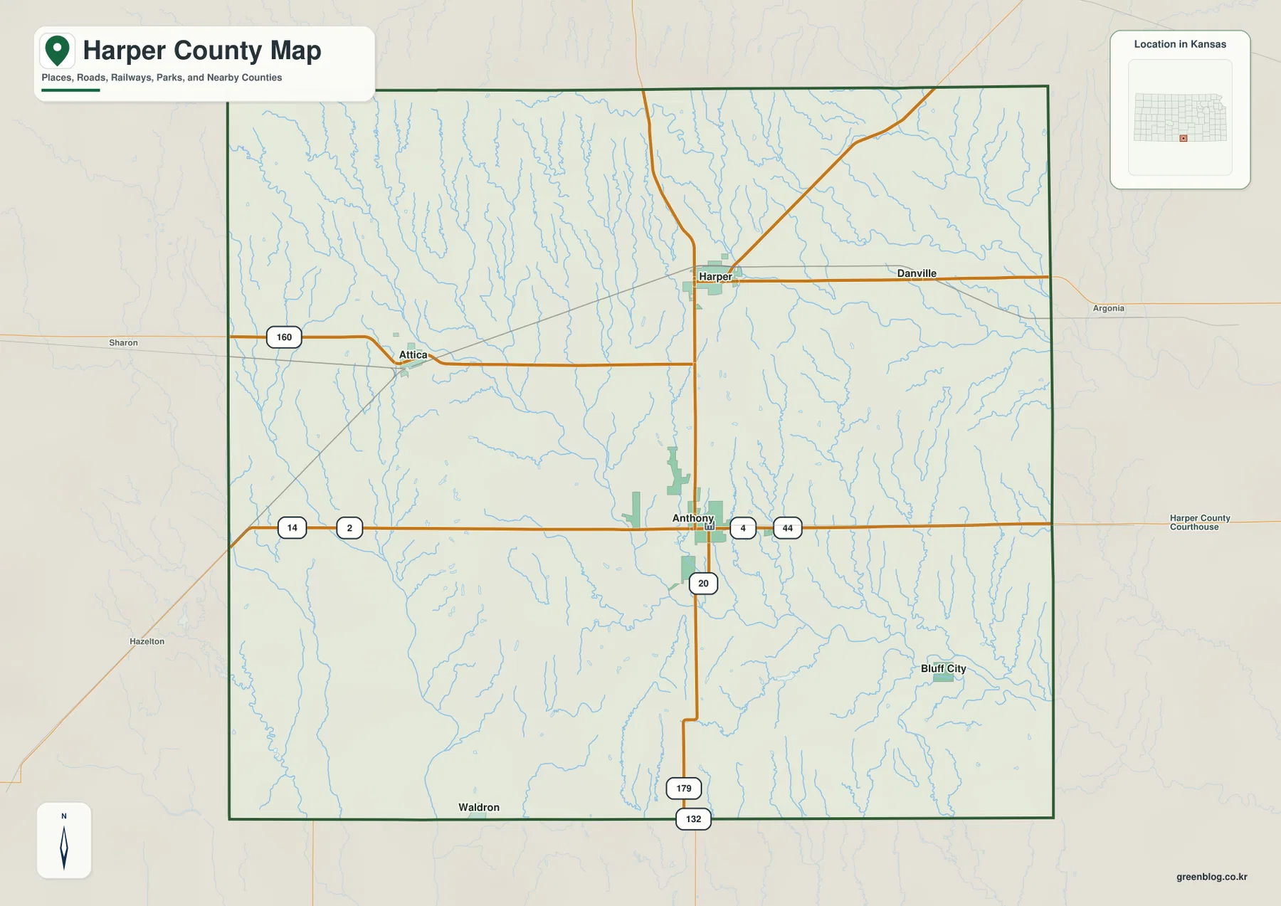
The northwest and north contain a dense network of small creek valleys, so the landscape is less uniform than the straight road grid suggests. Eastern and southeastern areas are also strongly shaped by the Chicaskia River and tributaries. The map is intended for county-scale orientation rather than live navigation, so current construction, flooding, unpaved-road conditions, and weather should be checked with up-to-date sources.
How Anthony, Harper, Attica, and the smaller towns are distributed
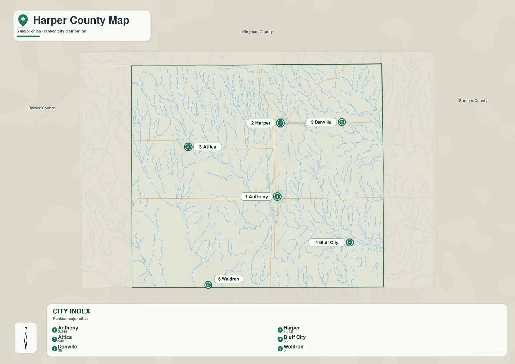
The city distribution map ranks Anthony first, Harper second, and Attica third. Bluff City, Danville, and Waldron are also listed, but their populations are much smaller. The values on the map reflect the source date used during map production, so the more useful geographic lesson is the contrast between three established town centers and several very small rural communities.
Anthony functions as the administrative and service center. Harper anchors the northern half, Attica helps define the northwestern U.S. 160 corridor, and Bluff City provides a southeastern reference near the creek country. Danville and Waldron are small, yet each helps identify a different county edge where otherwise there are long stretches of agricultural land.
The Kansas Historical Society identifies Anthony as the county seat. A disputed 1879 election between Anthony and Harper produced an implausibly large number of ballots and eventually reached the courts. Anthony ultimately retained the seat, and the modern map still reflects that administrative role through the prominence of the city and county offices.
Chicaskia River, Bluff Creek, and a dense network of tributaries
The terrain and water map places the Chicaskia River in the northeastern part of Harper County. Spring Creek and several smaller channels feed toward that area, while Sand Creek and Rush Creek cross the central uplands. The result is a landscape with many narrow valleys even where the general road map appears relatively open.
West Branch Bluff Creek and East Branch Bluff Creek are prominent in the western and north-central part of the county. Their valleys continue toward the Bluff Creek system farther south. Cottonwood Creek runs through the northwest, and Rock Creek and Glen Creek mark additional eastern drainages. Beaver Creek is labeled south of the central county.
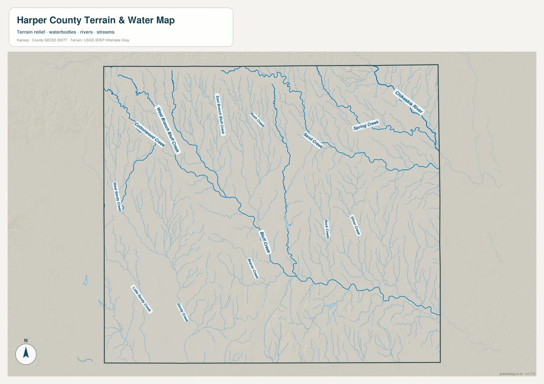
Little Sandy Creek and Sandy Creek cross the southwestern area and add another set of elongated valleys. There is no single large reservoir dominating the county, so the many smaller streams are especially useful for understanding relief. This map is a geographic reference rather than a live hydrology product, and current streamflow, flood conditions, or water quality should be checked through USGS or responsible local agencies.
A 354–533 meter contrast between northwestern uplands and eastern lowlands
The elevation map shows an actual county range of approximately 354 to 533 meters and a mean elevation near 418 meters. Brown and orange colors dominate much of the northwest and northern edge, marking the county’s highest surfaces. Moving east and southeast, the map shifts through yellow and light green into lower green terrain.
Creek valleys cut deeply into the higher northwestern surface and create narrow bands of lower elevation. The Chicaskia River and Bluff Creek systems occupy lower country farther east and southeast, while tributaries form repeated green corridors between ridges. Harper County is not mountainous, but the map clearly shows a rolling landscape rather than a single flat plain.
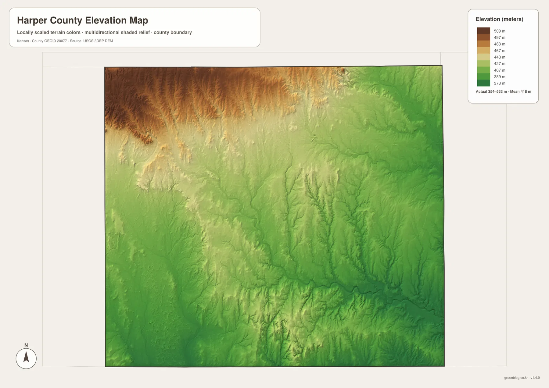
This elevation surface is intended for county-scale comparison rather than survey-grade measurement. It should not be used to establish exact parcel elevations, design drainage, or replace engineering and legal survey data. Its value is visual context: Anthony sits between the higher northwestern country and the lower eastern drainage network, making the broad relief change easy to understand.
Red Hills scenery and Harper County’s unusual early history
The Kansas Historical Society describes Harper County as crossing the Red Hills, High Plains, and Wellington-McPherson Lowlands. The nearby Gypsum Hills are known for flat-topped uplands, colorful soils, and deeply cut creek valleys. The elevation and water maps give that regional description a physical setting by showing higher western country and a dense network of lower channels.
Harper County was established in 1867, but its first attempted organization in 1873 was fraudulent. State investigators found that records had been created with fictitious residents even though the county had essentially no population. The county was disorganized and later legally reorganized in 1878.
A county-seat struggle followed between Anthony and Harper. In 1879 nearly 3,000 ballots were reported even though there were only about 800 legal voters, leading to another legal dispute. Anthony ultimately became the permanent seat, and voters approved a courthouse there in 1907. That unusual history gives the present-day city pattern extra context.
Using the maps for study, printing, and county orientation
For basic orientation, begin with Anthony and then place Harper, Attica, and Bluff City around it. For physical geography, follow the Chicaskia River and Bluff Creek systems, then compare the same locations with the elevation map. The contrast between higher northwestern terrain and lower eastern valleys becomes much easier to see when the water and elevation views are used together.
The high-resolution JPG files in the ZIP are better suited than the reduced web previews for printing, classroom projects, local-history materials, and close inspection of labels. They are useful for county overviews and regional comparison, but current roads, live stream conditions, parcel boundaries, and exact elevations should always be checked against the latest authoritative sources when those details matter.
Frequently Asked Questions
Where is Anthony on the Harper County map?
Anthony sits slightly south of the county center and serves as the county seat and largest community. Harper lies to the north, Attica to the northwest, and Bluff City to the southeast, making Anthony the easiest first reference for county orientation.
Where are the Chicaskia River and Bluff Creek systems?
The Chicaskia River crosses the northeastern part of the county, while the Bluff Creek system occupies the central and southeastern drainage network. West Branch and East Branch Bluff Creek, along with several smaller tributaries, cut lower valleys through the surrounding uplands.
Can the 354–533 meter elevation map be used for surveying?
No. The elevation map is a county-scale visual reference for comparing uplands and valleys. Exact parcel elevations, construction design, drainage engineering, and legal surveys require purpose-built data and professional methods appropriate to those tasks.
Map File Information
Download the high-resolution JPG files corresponding to the Harper County general, city distribution, terrain-and-water, and elevation maps in one ZIP archive.
- Included Files: Use only the versions confirmed in the article and supplied images
- File Type: Use the confirmed download contents
- Intended Use: Printing, education, presentations, and map-based projects
Related Maps
Sources and references
- Harper County, Kansas official website — county government and Anthony information
- Kansas Historical Society — Harper County, Kansas — county-seat history, physiographic regions, and local background
- U.S. Census Bureau TIGER/Line — boundary, road, and geographic data resources
- USGS National Hydrography — hydrography and stream-network data information
- USGS 3D Elevation Program — elevation data information
Green Map creates custom-edited map images using open geographic data sources such as geoBoundaries, Natural Earth, OpenStreetMap, and government open data.
These maps are edited visual materials, not raw data files, and are provided for education, documents, presentations, and graphic reference.