If you need a Coffee County Alabama Map for printing, classwork, a presentation, or a quick geographic reference, this page provides four separate views of the county and a downloadable file set. You can compare the county boundary and main roads, the spacing of key communities, the river and creek network, and the county’s elevation pattern. A single ZIP download contains four high-resolution A3 JPG maps, so the full set can be saved without collecting the images one at a time.
Coffee County is easier to understand when Elba and Enterprise are used as the first two reference points. Elba lies in the western part of the county near Pea River, while Enterprise occupies the eastern side close to the county boundary. New Brockton sits between them, and Kinston is farther to the southwest. U.S. 84 links the main east-west line of communities, but the water and elevation maps show a different side of the county: Pea River, Whitewater Creek, and their tributaries occupy lower corridors between rolling uplands. Looking at these features separately keeps the maps readable while still letting the four views work together.
Table of Contents
Elba, Enterprise, and the main road pattern
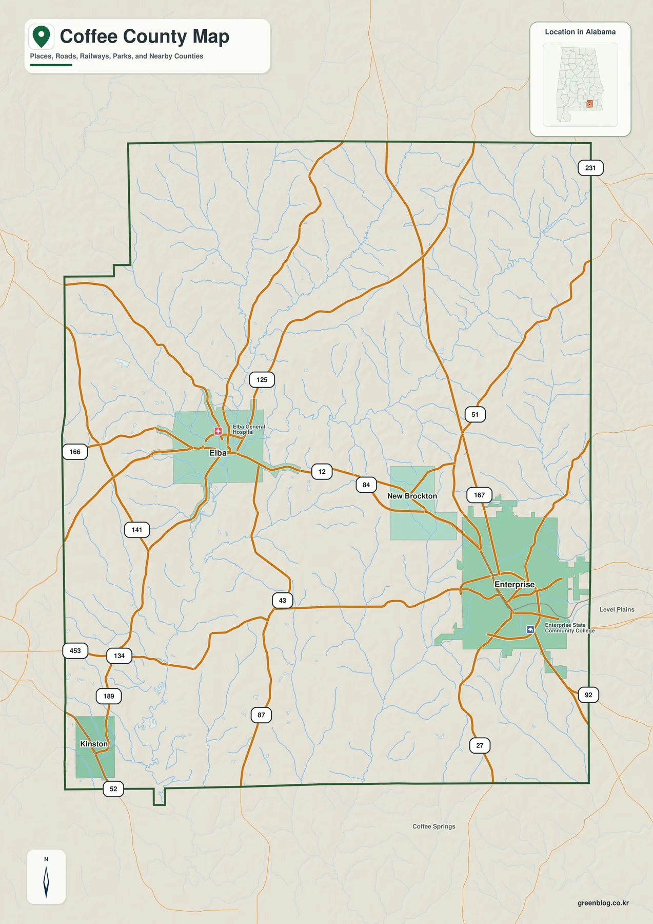
The main county map is the best place to establish orientation. Elba is located in the western-central part of Coffee County, while Enterprise is near the eastern edge. New Brockton falls between those two cities, and Kinston sits to the southwest rather than on the same east-west line. Labels for Pike, Dale, Geneva, Covington, and Crenshaw counties provide additional context, making it easier to see where Coffee County fits within southeastern Alabama.
U.S. 84 is the most obvious road for comparing the county’s principal communities. It runs east from Elba through New Brockton toward Enterprise, giving readers a simple route to follow across the map. State routes including AL 87, AL 51, AL 167, AL 125, and AL 189 add north-south and local connections. The map is not intended to replace detailed navigation, but it clearly shows which roads connect the main places and which directions lead toward neighboring counties.
Elba and Enterprise also have noticeably different settings. Elba is a smaller urban center close to Pea River, while the Enterprise area shows a broader spread of roads and developed land. Elba is the official county seat, and Coffee County also has court functions in Enterprise. That two-city relationship is useful when reading the map because county activity is not concentrated at only one point. For general orientation, treating both Elba and Enterprise as anchors gives a more accurate picture of how the county is organized.
How the major communities are spaced across Coffee County
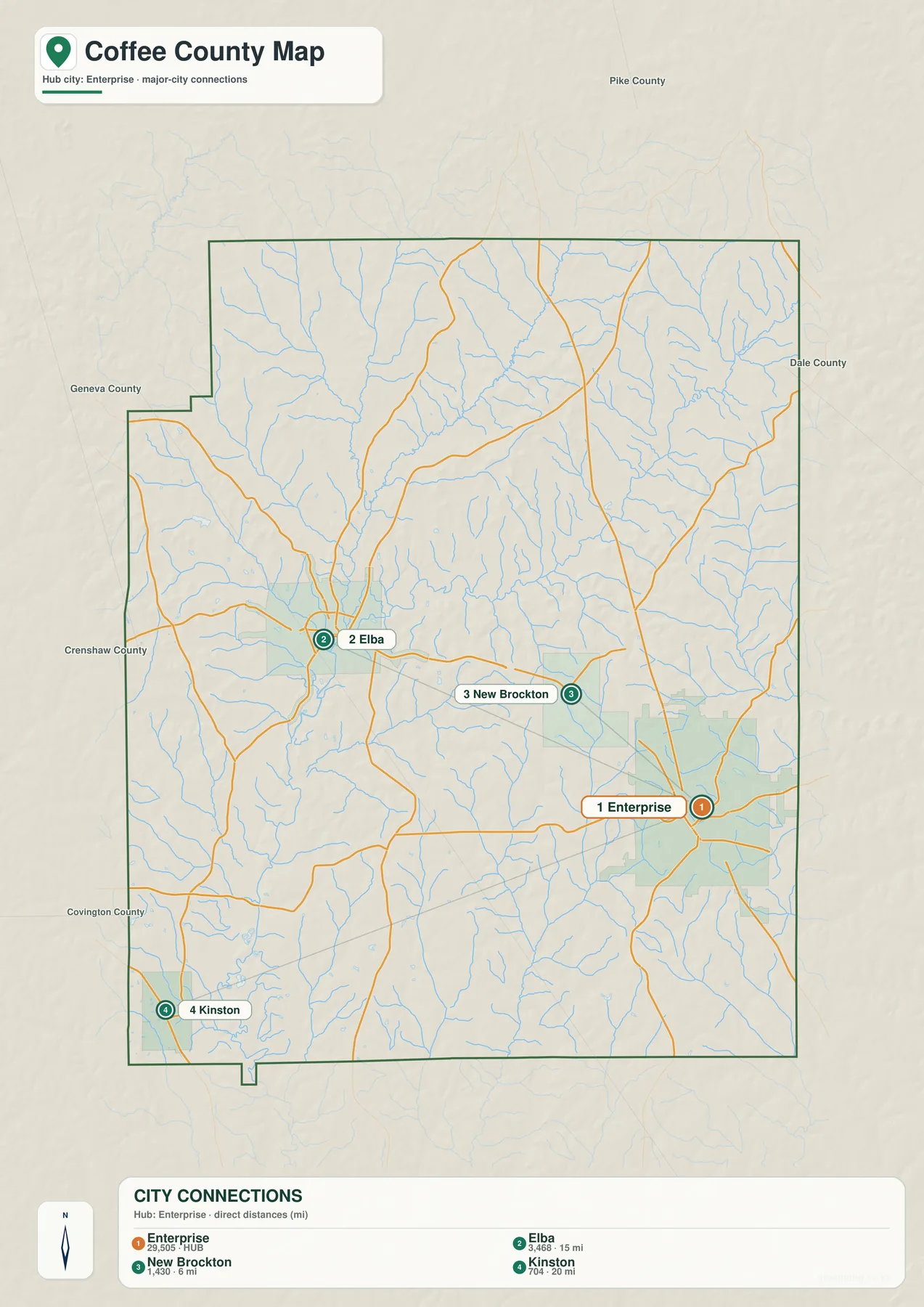
The community map removes most of the road detail and focuses on the relative position of the county’s better-known places. From Enterprise, New Brockton is shown at about 6 miles, Elba at about 15 miles, and Kinston at about 20 miles. These are straight-line distances between mapped points, not the mileage a driver would record on the road. Actual driving distance and travel time depend on the selected route, intersections, and road conditions.
The directions are just as informative as the numbers. New Brockton is close to Enterprise on the west side, and Elba lies farther in the same general direction. Kinston is southwest of Enterprise, which places it away from the main Enterprise-New Brockton-Elba sequence. That pattern helps explain why a simple east-versus-west description does not fully capture the county’s settlement layout. The city map is especially useful for a classroom or presentation because the relationships can be understood quickly without tracing every highway.
For trip planning, this view works best as an orientation tool. It can tell you whether a destination lies toward Elba, close to New Brockton, or down toward Kinston, but it does not account for the road network between those places. A current navigation service is still the right choice for turn-by-turn directions and live travel times. The value of the community map is its simplicity: it makes the county’s basic spacing easy to remember before more detailed information is added.
Pea River and the creek network around Elba
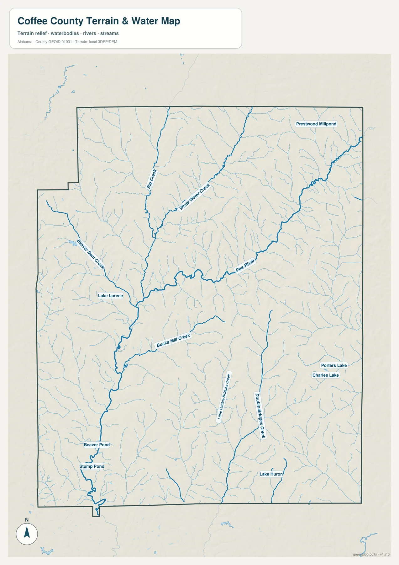
Pea River is the strongest feature on the water map. It passes through the western-central part of Coffee County and continues south near Elba. Whitewater Creek approaches the Elba area from the northeast and joins the Pea River. On the road map Elba is primarily a city on the western side of the county; on the water map its location gains another layer of meaning because two important waterways come together nearby.
Other named streams extend the drainage pattern across the county. Big Creek is prominent in the north, Beaver Dam Creek appears toward the west, and Bucks Mill Creek and Double Bridges Creek are labeled farther south. The map also names smaller water bodies such as Lake Lorene, Prestwood Millpond, Porters Lake, Charles Lake, Lake Huron, Beaver Pond, and Stump Pond. These local labels make it easier to follow the branching network from smaller tributaries toward the larger channels.
The relationship between Elba and the river system has practical historical importance. A U.S. Geological Survey study examined flooding involving Pea River and Whitewater Creek at Elba, confirming that these waterways have long mattered to the city’s physical setting. The map on this page, however, is a general hydrographic reference. It does not define a current flood zone, a wetland boundary, or a property-level hazard area, and it should not be used for insurance or land-development decisions.
Lower river valleys between rolling uplands
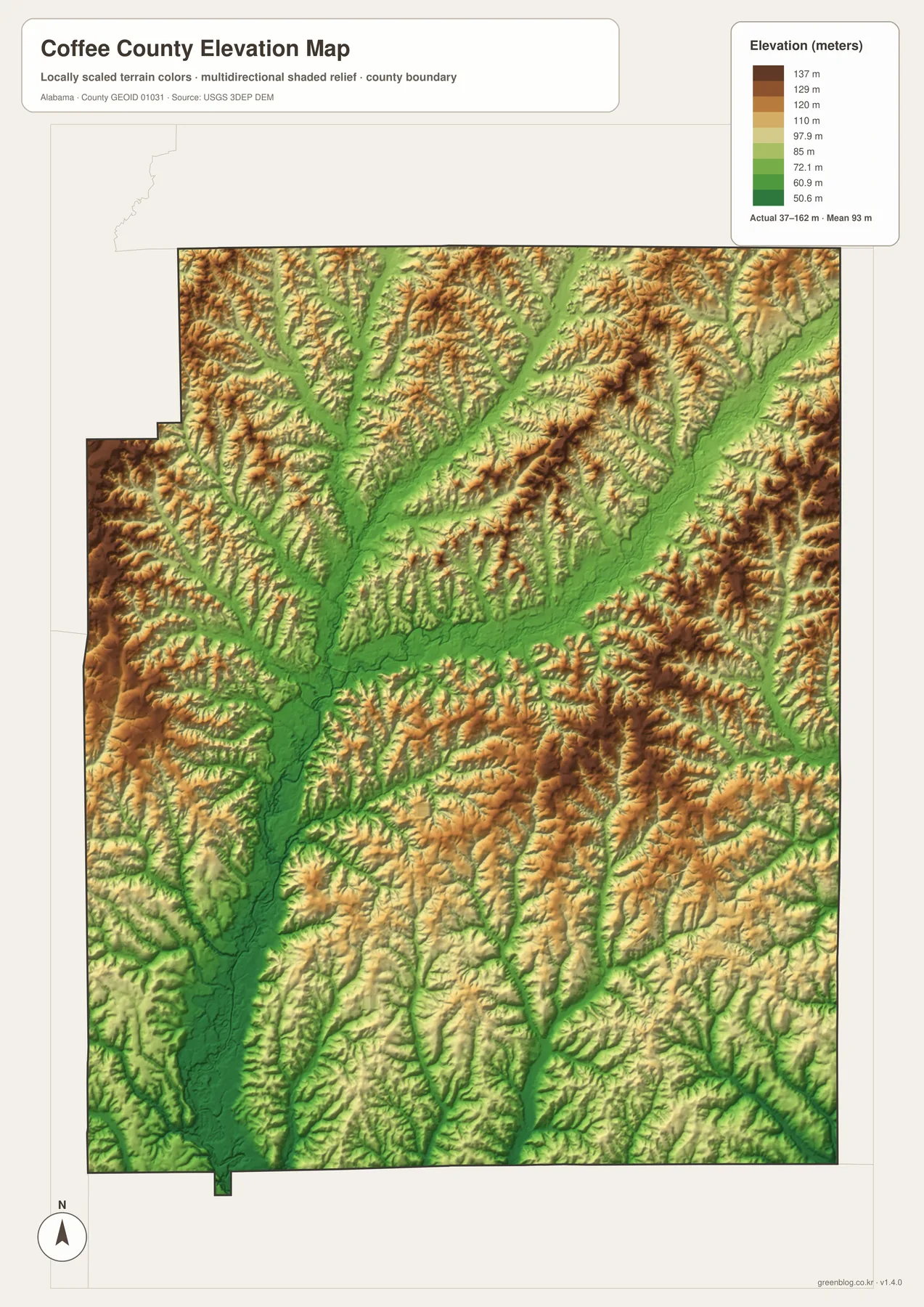
The elevation map adds terrain that is not obvious on the road or community views. Its legend shows an elevation range of about 37 to 162 meters, with a mean near 93 meters. Greens mark the lower areas, while yellow and brown tones represent progressively higher ground. The result is not a single broad plain. Instead, Coffee County appears as a series of branching low corridors divided by narrow ridges and gently rolling uplands.
The Pea River valley is easy to locate as a long lower corridor through the western-central part of the county. Whitewater Creek and smaller tributaries occupy thinner low paths that branch toward the main river system. Higher land fills the areas between the drainages, with somewhat stronger relief visible in parts of the north and east. Comparing the water map with the elevation map makes the connection clear: many blue stream lines follow the same low green corridors shown by the terrain colors.
This map is intended for county-scale comparison rather than precise surveying. It is useful for seeing which parts of the landscape are relatively low or high and for understanding why rivers and creeks occupy certain corridors. It is not accurate enough to establish the exact elevation of a building site, road grade, or property corner. Detailed engineering, construction, or boundary work requires more precise source data and, when appropriate, field measurements.
Choosing the right Coffee County map for the task
A useful way to work through the set is to begin with the county map, locate Elba and Enterprise, then follow U.S. 84 through New Brockton. Once that framework is familiar, the community map gives a faster comparison of direction and straight-line distance. If the western side of the county is the focus, move to the water map to trace Pea River and Whitewater Creek, then check the elevation map to see how those channels occupy lower ground between the surrounding uplands.
- Boundaries, roads, and places: use the county map for neighboring counties, Elba, Enterprise, New Brockton, Kinston, U.S. 84, and the main state routes.
- Community spacing: use the city map when direction and straight-line distance matter more than the details of the road network.
- Rivers and streams: use the water map to follow Pea River, Whitewater Creek, Big Creek, and the smaller named waterways and ponds.
- Terrain: use the elevation map to compare low drainage corridors with the ridges and rolling uplands between them.
Because each topic is kept on its own map, the set works well for printing and for presentations where one question needs to be explained at a time. A teacher can start with roads and communities, then introduce the river network, while a local-history presentation can use Elba’s relationship with Pea River as geographic context. The elevation map can then add a simple explanation of why stream valleys are lower than the nearby uplands without crowding the page with extra road labels.
The maps are also useful during the early stages of trip or project planning. They can show whether a place belongs on the Elba side, the Enterprise side, or toward Kinston, and they provide a quick way to remember the county’s major road and river relationships. They do not replace live traffic data, parcel records, legal boundary surveys, current flood-hazard maps, or detailed engineering information. Those specialized decisions should always be checked against the appropriate current source.
Frequently Asked Questions
What files are included in the Coffee County download?
The ZIP contains four separate high-resolution A3 JPG files: a county and road map, a community map, a water map, and an elevation map.
Are the distances on the community map driving distances?
No. The values from Enterprise to New Brockton, Elba, and Kinston are straight-line distances between mapped points. Driving mileage and travel time depend on the road route.
Can the water map be used to determine flood risk?
No. It is a general reference for rivers, streams, and water bodies. Current flood-risk, insurance, or property decisions should be based on the appropriate official hazard data.
Map File Information
The download package contains the Coffee County boundary and road map, community map, water map, and elevation map as four separate high-resolution A3 JPG files . One ZIP keeps the complete set together for printing, classroom use, presentations, and other map-based projects.
- Included Files: County, City, Water, Elevation maps
- File Type: 4 high-resolution A3 JPG files in one ZIP
- Intended Use: Printing, education, presentations, and map-based projects
Related Maps
- Along the Cahaba Valley: Bibb County Alabama Map
- Between Two River Systems: A Clarke County Alabama Map
- Calhoun County Alabama Map
- Alabama Population Density Map: Urban Clusters, County Totals and a Decade of Change
- Coffee County Alabama Land Cover Map: Northern Forest and Southern Farmland
Sources and references
- Coffee County official history
- Alabama DOT Coffee County functional-classification map
- USGS study of Pea River and Whitewater Creek flooding at Elba
- USGS 3D Elevation Program
Green Map creates custom-edited map images using open geographic data sources such as geoBoundaries, Natural Earth, OpenStreetMap, and government open data. These maps are edited visual materials, not raw data files, and are provided for education, documents, presentations, and graphic reference.