A Clarke County Alabama Map is easiest to understand by using Grove Hill and Jackson as the first reference points. Grove Hill sits near the county center, Jackson is farther southwest, Thomasville is to the northeast, Fulton occupies an eastern interior position, and Coffeeville lies closer to the western river side. The southern section narrows into a complex lowland landscape shaped by creeks, lakes, and larger waterways. This page also provides a downloadable ZIP of high-resolution A3 JPG files for printing, classroom use, presentations, and offline reference.
The terrain changes noticeably across the county. Higher rolling ground is more common in the east and northeast, while lower land spreads across much of the west and the long southern section. Starting with roads and communities and then comparing water and relief makes the irregular county outline and the spacing between towns much easier to understand.
Table of Contents
Grove Hill and Jackson define the main road frame
U.S. 43 provides the clearest north–south reference through Clarke County. It links Jackson with Grove Hill and continues toward Thomasville, while U.S. 84 crosses the central portion and adds an important east–west route. Once those highways are located, Fulton and Coffeeville can be placed more easily in relation to the better-known towns.
The southern outline is especially distinctive. Instead of ending in a broad straight boundary, Clarke County narrows through an irregular section with numerous bends. Those bends make more sense after the waterways are examined because low terrain, streams, lakes, and larger river features become increasingly important toward the south.
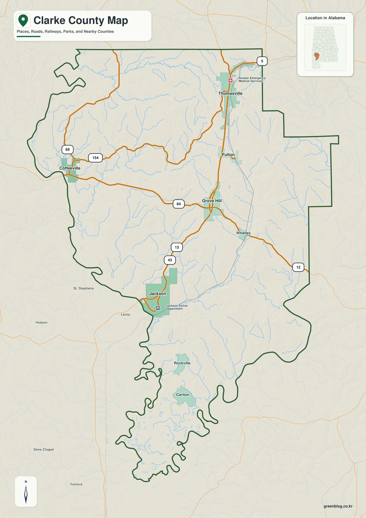
This overview is intended for regional orientation rather than turn-by-turn travel. It is useful for seeing which communities lie along the U.S. 43 corridor, how U.S. 84 crosses the county, and why the southern outline differs from the broader northern and central areas.
Jackson provides a simple hub for comparing the major towns
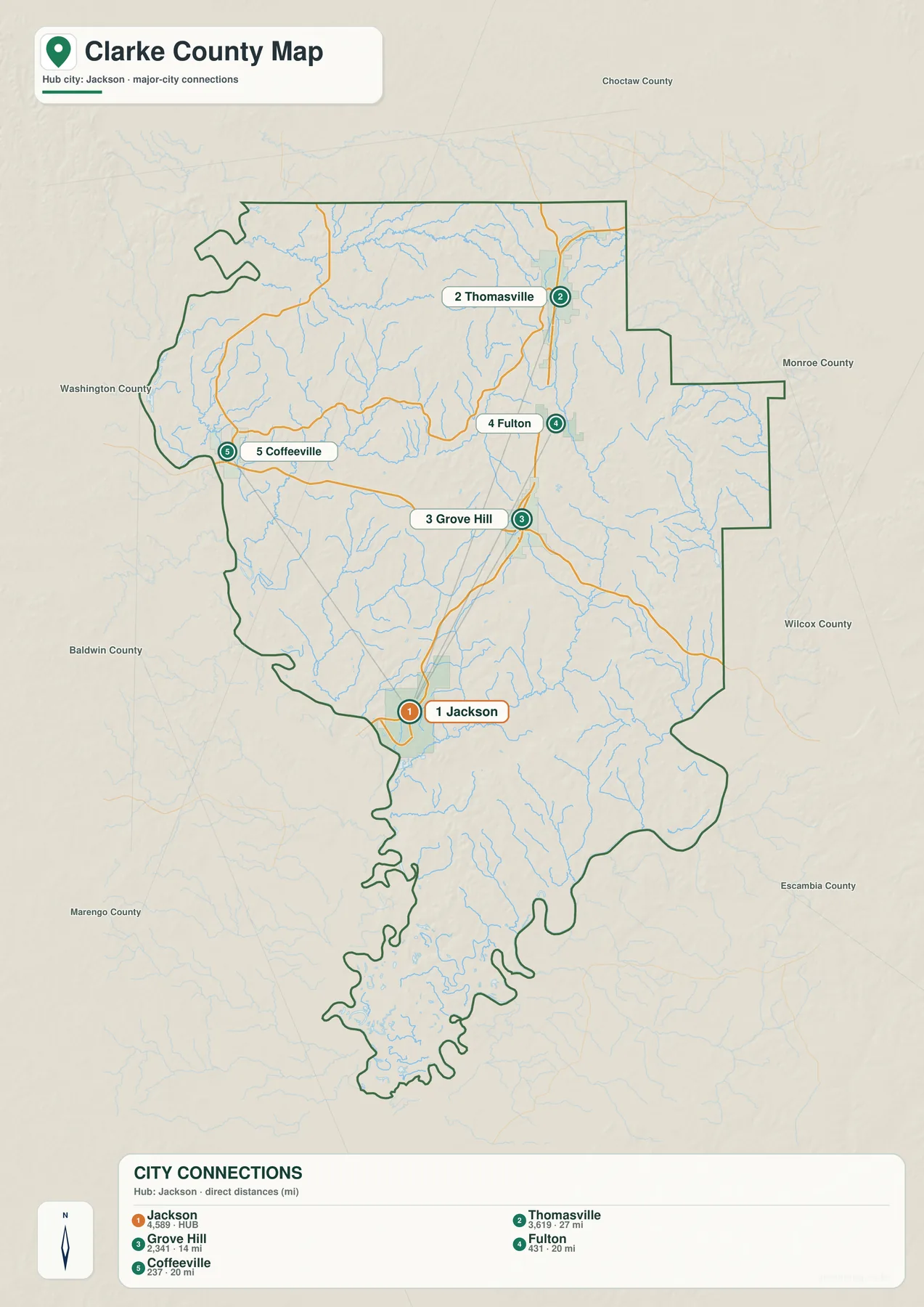
The city-focused view simplifies the relationship between Jackson, Grove Hill, Thomasville, Fulton, and Coffeeville. Grove Hill is north of Jackson and serves as the county seat. Thomasville is farther northeast, Fulton lies between the central and northeastern areas, and Coffeeville is separated toward the west.
Connector lines or distance labels should be treated as straight-line references, not driving mileage. Actual routes can be longer because roads curve around creeks, lowlands, and limited crossings. For a presentation or classroom exercise, however, the simplified arrangement is useful for showing why Clarke County has several distinct local centers rather than one compact urban cluster.
Creeks branch across the county and become more complex in the south
A dense drainage network crosses Clarke County. Bashi Creek and Little Bashi Creek are in the north, Satilpa Creek and Tallahatta Creek appear farther west, Jackson Creek drains the central-southwestern area, and Bassett Creek provides an eastern reference. Numerous smaller tributaries create a fine branching pattern between these named channels.
Choctaw Lake, Johnson Lake, Hal’s Lake, Round Pond, and Pugh Lake add recognizable water bodies across the lower and interior parts of the county. Near the southern end, water edges and low ground become especially complicated. The Alabama River is also an important southeastern reference, helping explain why the county outline contains so many bends in that direction.
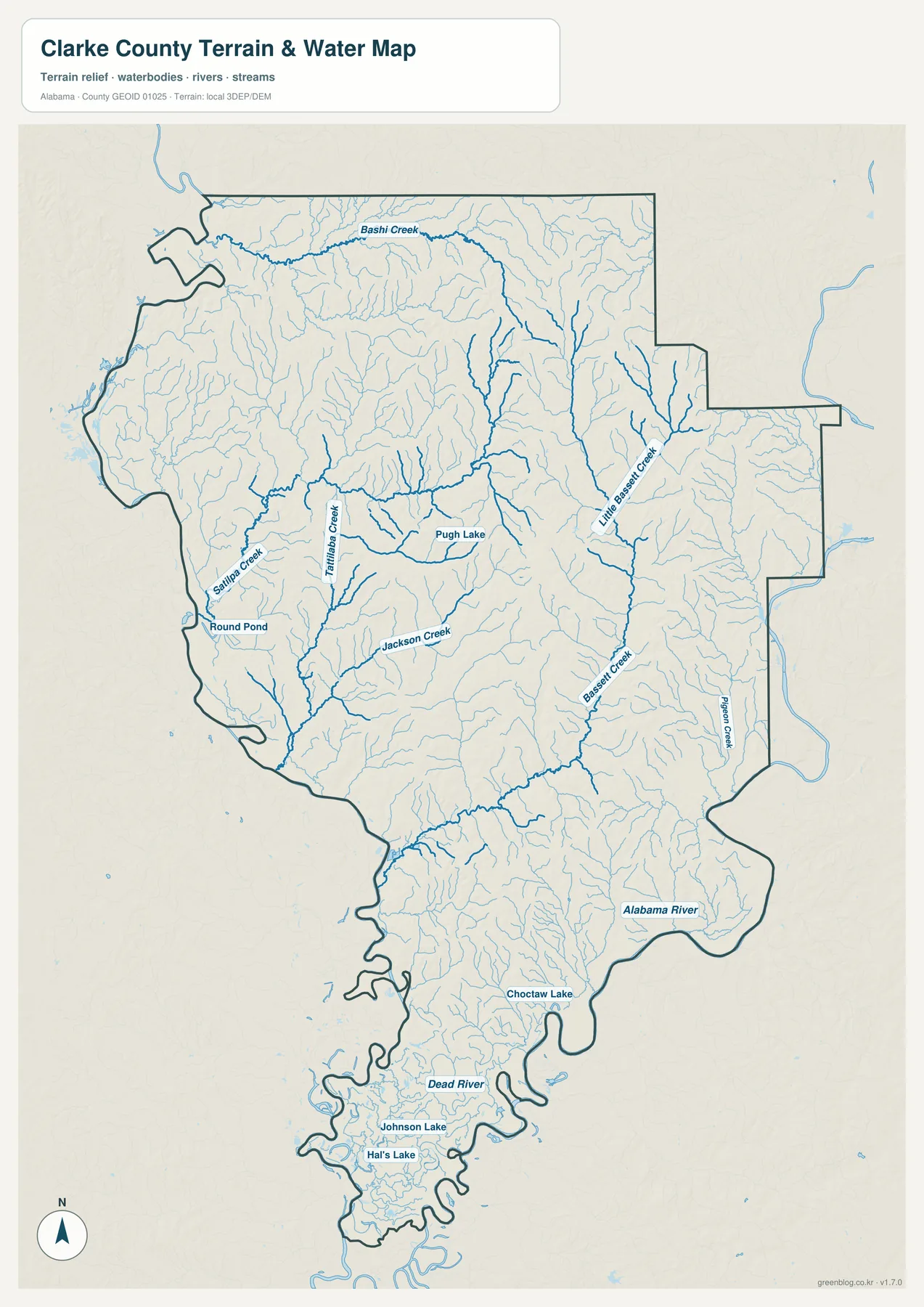
This map is designed for geographic reference, not flood, navigation, or property decisions. Flood zones, water depth, legal shoreline limits, parcel boundaries, and current water conditions should be checked with the appropriate official sources.
Higher eastern ridges contrast with southern and western lowlands
Relatively higher ridges and rolling ground occur more often in the eastern and northeastern parts of Clarke County. Much of the western side and the long southern section is lower. These are local differences within the county rather than mountain-scale elevations, so darker or warmer terrain colors simply indicate higher ground relative to nearby valleys and river lowlands.
Comparing elevation with the water network helps explain the drainage pattern. Small creeks descend through valleys from higher interior ground and eventually enter broader, lower areas toward the south and west. The concentration of low terrain around the southern water features is especially easy to recognize when the two subjects are compared.
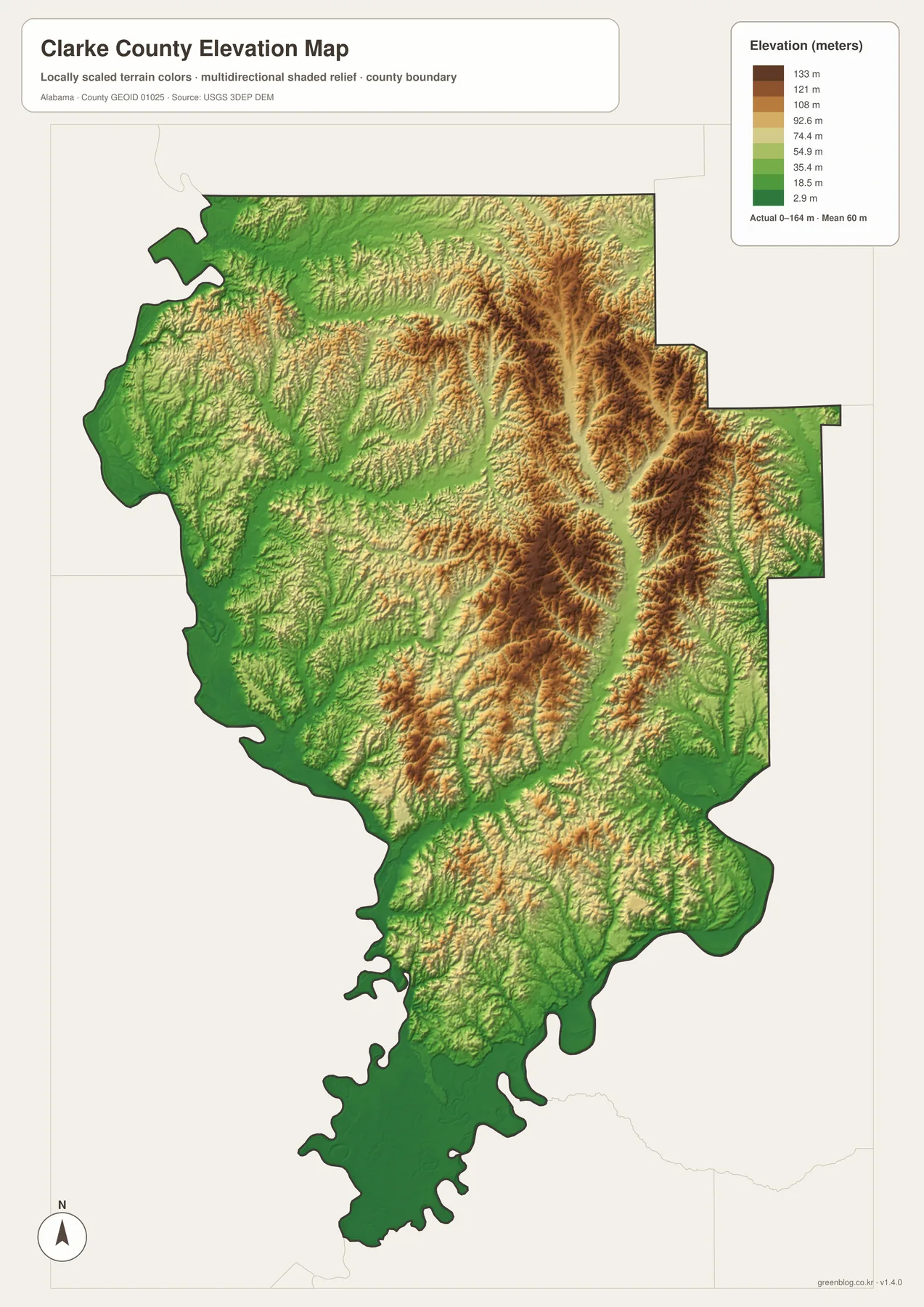
The shaded surface is generalized for county-wide comparison. It can help identify broad ridges, valleys, and lowlands, but it should not be used as survey-grade elevation data for a specific parcel, construction project, or drainage design.
Choose the view that matches the information you need
For basic orientation, start with Grove Hill, Jackson, Thomasville, and the main highways. When relative town positions matter more than road detail, use the city-focused view. The water layer is better for creeks, lakes, the Alabama River, or the unusual southern boundary, while the elevation layer explains the contrast between eastern ridges and lower southern and western terrain.
- Roads and boundaries: locate Grove Hill, Jackson, Thomasville, U.S. 43, and U.S. 84.
- Town placement: compare Jackson with Grove Hill, Thomasville, Fulton, and Coffeeville.
- Water: trace Bashi, Satilpa, Tallahatta, and Jackson creeks along with southern lakes.
- Terrain: compare higher eastern ground with lower western and southern areas.
Keeping these topics separate also makes printed pages and presentation slides easier to read. A discussion of towns and roads does not need every stream label, while a physical-geography lesson benefits from the specialized water and elevation views. The same county boundary remains familiar even as the subject changes.
Download the Clarke County A3 JPG files
The ZIP below contains high-resolution JPG versions covering the county boundary and roads, city relationships, waterways, and elevation. The WebP images in the article are intended for quick browser viewing, while the larger JPG files are better suited to printing, classroom handouts, posters, presentations, and other offline uses.
Frequently Asked Questions
Which map should I use to understand the southern county boundary?
Use the county map first to see the full outline, then compare the same area on the water map. The southern part of Clarke County has many bends and low-water features, so the water layer gives more context than a boundary line by itself.
What is included in the downloadable Clarke County map package?
The ZIP contains four A3 high-resolution JPG files covering the county boundary and roads, city relationships, waterways, and elevation. The body of this page uses lighter WebP previews so the maps can be viewed quickly before downloading the larger files.
Map File Information
Download Clarke County files for roads, communities, waterways, and terrain.
- Included Files: county map, city map, water map, elevation map
- File Type: high-resolution JPG files in one ZIP
- Intended Use: printing, education, presentations, and regional reference
Alabama County Map Index
Related Maps
- Along the Cahaba Valley: Bibb County Alabama Map
- Calhoun County Alabama Map
- Clay County Alabama Map
- Alabama Population Density Map: Urban Clusters, County Totals and a Decade of Change
- Clarke County Alabama Land Cover Map — Forest-Wetland Pattern and Four JPG Views
Sources and further reference
- Clarke County official location and community information
- Clarke County official history
- Alabama Department of Transportation maps
- USGS National Hydrography
- USGS 3D Elevation Program
Green Map creates custom-edited map images using open geographic data sources such as geoBoundaries, Natural Earth, OpenStreetMap, and government open data. These maps are edited visual materials, not raw data files, and are provided for education, documents, presentations, and graphic reference.