Barren County lies in south-central Kentucky, with Glasgow as the county seat and principal road hub. Cave City and Park City sit in the northwestern cave country, while the long arms of Barren River Lake reach into the southwest. US 31E, US 31W, US 68, KY 80, KY 90, and numerous state routes cross a landscape shaped by karst drainage, wooded creek valleys, and rolling ridges. High-resolution map files are available for download in the section below.
This guide follows Glasgow, Cave City, Park City, the main roads, Barren River Lake, Sinking Creek, and terrain ranging from about 141 to 324 meters. WebP previews are available for quick viewing, and the matching high-resolution JPG files can be downloaded together in one ZIP for printing, classroom work, or offline reference.
Table of Contents
Glasgow anchors county government and the central road network
Glasgow sits near the middle of Barren County, where US 31E, US 68, KY 80, KY 90, and KY 740 provide the strongest regional references. KY 685 heads toward the Park City side, while KY 249, KY 63, and KY 87 connect the southern countryside. The road pattern is densest around Glasgow and becomes increasingly rural toward the county edges.
Barren County’s official government site identifies Glasgow as the county seat and explains that the county was created in 1798 from parts of Green and Warren counties. The county name came from the open meadowlands once called “the barrens,” not from infertile soil. A Kentucky Historical Society marker also records Glasgow’s founding in 1799.
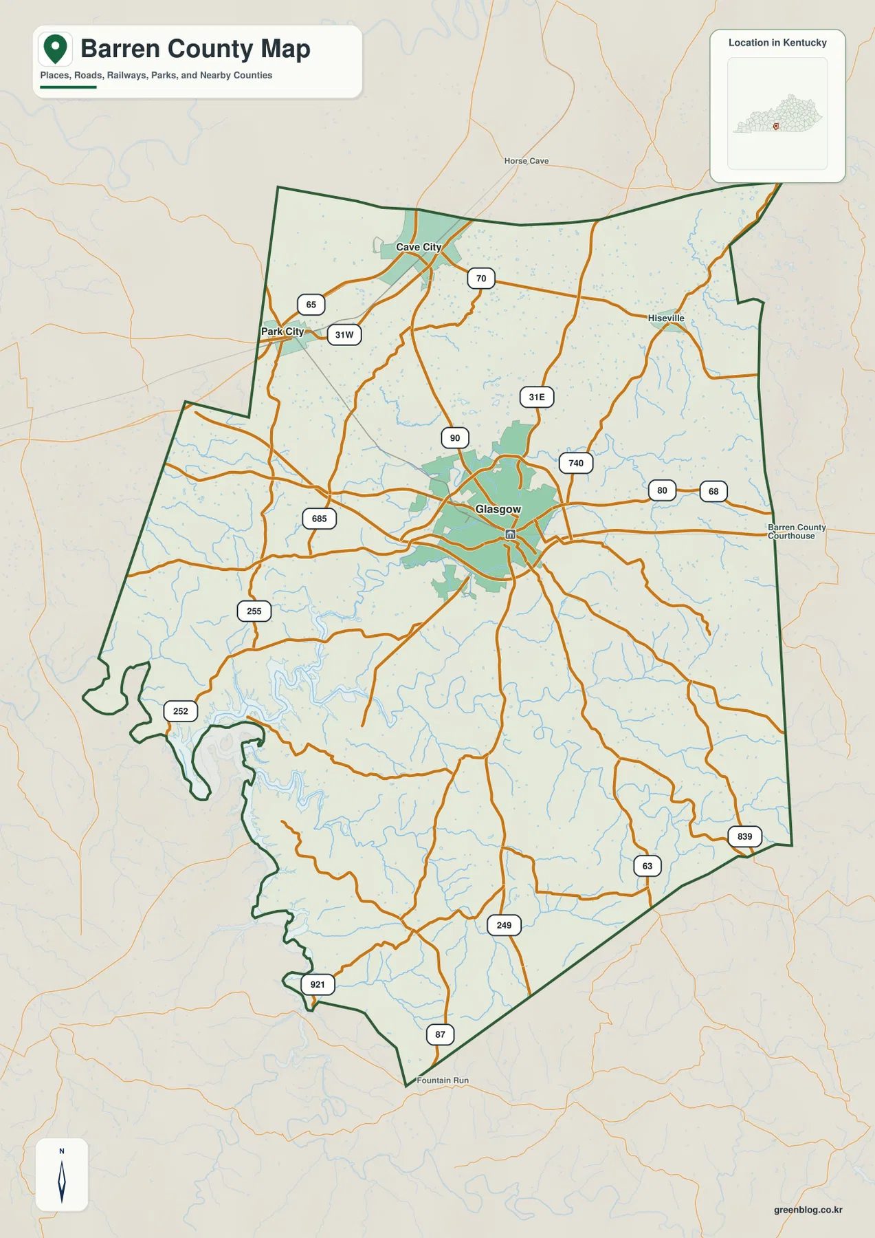
Cave City and Park City sit close together in the northwest near US 31W, KY 70, and KY 65. Horse Cave lies just beyond the northern boundary, and Hiseville provides an eastern reference on the KY 70 side. South of Glasgow, settlement becomes much thinner and creek valleys become increasingly useful for orientation.
The city-connections panel links Glasgow with Cave City and Park City
The supplied city-connections panel places Glasgow at an index value of 15,197, Cave City at 2,730, and Park City at 670. These are map index values rather than current official population estimates. Both Cave City and Park City are labeled at roughly 9 miles straight-line distance from Glasgow; those labels are not road-driving distances.
The equal distance labels hide different local roles. Cave City is one of the main gateways to the Mammoth Cave tourism region, while Park City is a smaller northwestern community. The City of Cave City notes that visitors have used the community as an access point for Mammoth Cave since the early nineteenth century.
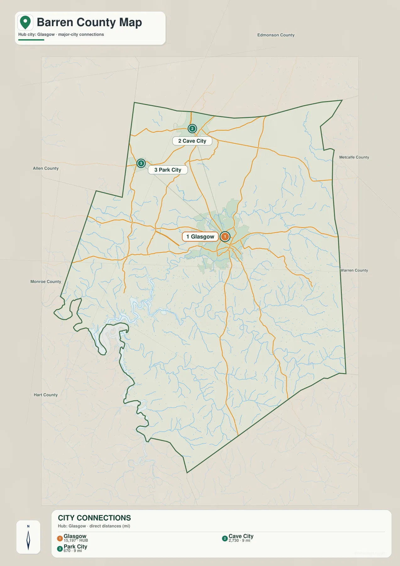
Glasgow remains the administrative and service center, but Cave City and Park City are essential for understanding the northwestern part of the county. The cave country around them differs from the lake-dominated southwest and the higher dissected hills farther east.
Sinking Creek and Beaver Creek tributaries divide the karst uplands
Sinking Creek and Little Sinking Creek are the clearest named drainages in the northwest. Brushy Fork and many short tributaries occupy the same area, where surface streams can be discontinuous in the limestone landscape. That setting is consistent with the broader Mammoth Cave and karst region near Cave City and Park City.
Across the county interior, South Fork Beaver Creek and Boyds Creek form long low corridors through the central hills. Skaggs Creek and Nobob Creek break up the eastern side, while Caney Fork, Dry Fork, Glovers Creek, and Mill Camp Branch drain the southern terrain.
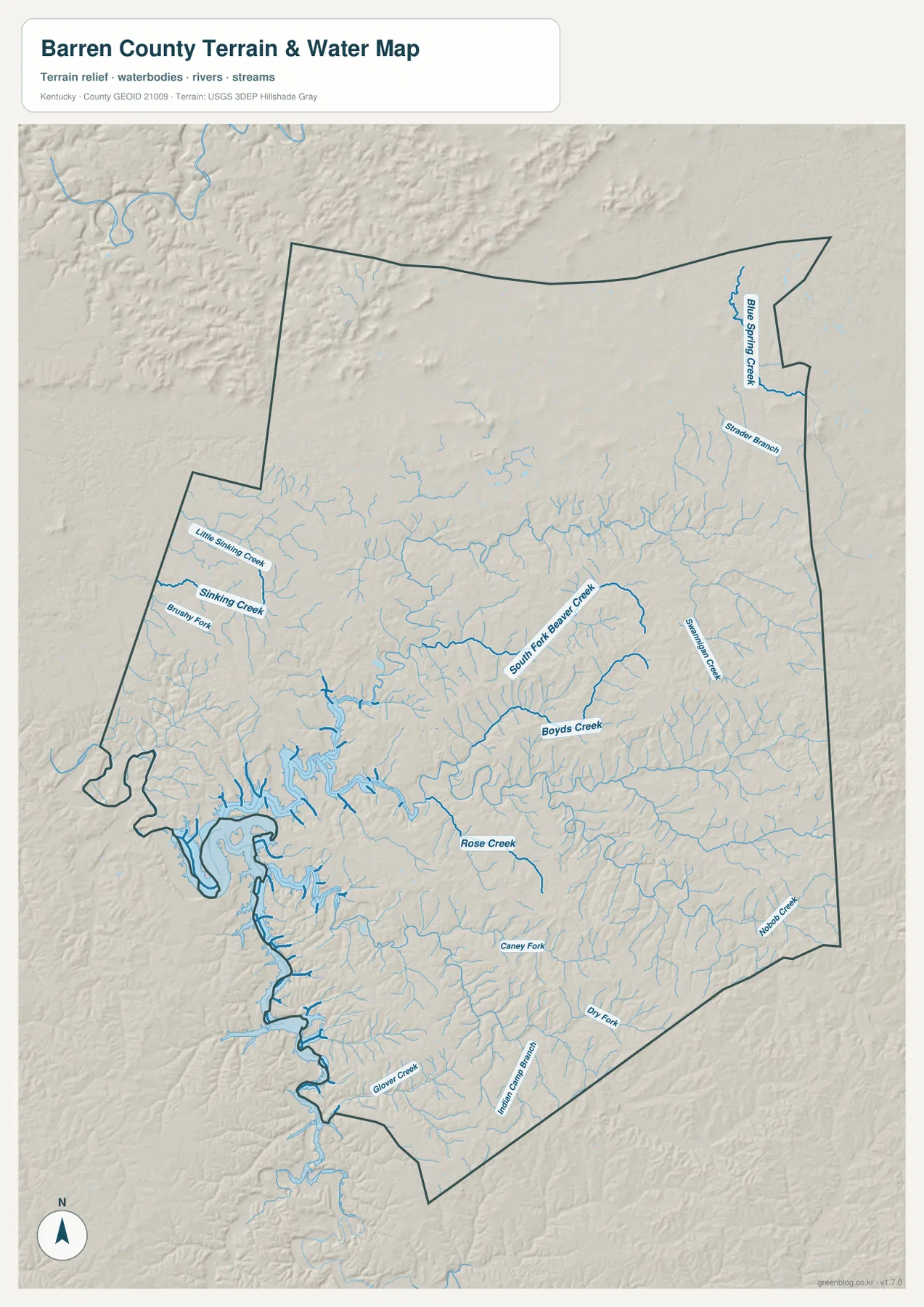
Barren River Lake is the largest water feature in the southwestern part of the package. Long reservoir arms occupy former creek valleys and create a much broader lowland pattern than the narrow stream corridors elsewhere. Kentucky State Parks describes the lake as roughly 10,000 acres and supports fishing, boating, hiking, and other recreation at Barren River Lake State Resort Park.
This image is intended for geographic reference rather than floodplain, navigation, water-quality, parcel, or legal-access decisions. Water levels and access conditions can change, so current agency information should be checked whenever boating, fishing, or shoreline access matters.
Elevation from 141 to 324 meters contrasts lake lowlands with higher eastern hills
The elevation surface ranges from about 141 to 324 meters, with a mean near 223 meters. Dark green low terrain surrounds Barren River Lake and several large creek valleys, while tan and brown ridges become much more common across the east and southeast. The northwest around Cave City also contains pronounced ridges and depressions associated with the cave-country landscape.
South Fork Beaver Creek and Boyds Creek cut long green bands through the central uplands. Skaggs Creek and Nobob Creek divide the higher eastern terrain into narrow ridges, while the reservoir side opens into broader low valleys toward the southwest.
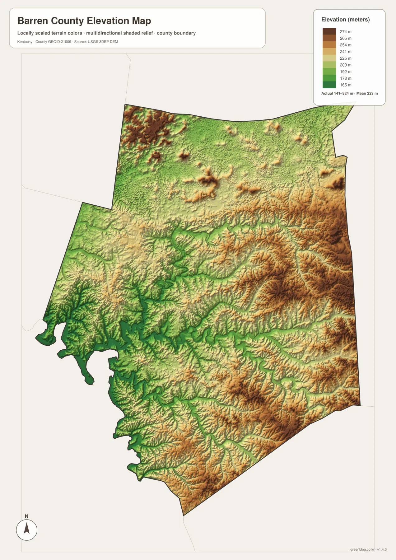
Glasgow occupies intermediate terrain near the county center. Moving east brings a stronger sequence of narrow valleys and high ridges, while traveling toward the reservoir produces a general drop in elevation and wider valley floors.
The elevation surface is generalized for county-scale comparison. It is not survey-grade or engineering-grade measurement and should not be used for parcel elevations, construction grades, drainage design, or legal boundary work.
Cave City connects Barren County with the Mammoth Cave region
Cave City’s official tourism material describes the community as a long-standing gateway for Mammoth Cave visitors dating back to the early 1800s. Today the US 31W and KY 70 area contains lodging, visitor services, and attractions that support travel into the broader cave region.
That role gives Cave City a different identity from Glasgow. Glasgow is the county-seat and service center, while Cave City is tied more directly to karst landscapes and tourism. The county map makes the short distance between the two communities clear, even though their surroundings and functions differ.
Barren River Lake defines the southwest with broad water and low relief
Kentucky State Parks operates Barren River Lake State Resort Park near Lucas and describes a roughly 10,000-acre lake used for boating, fishing, hiking, golf, and other recreation. The reservoir occupies one of the lowest parts of the county map and sends long arms into tributary valleys.
On the water and elevation images, the lake area looks very different from the narrow creek country farther east. The shoreline is deeply indented, and the surrounding low relief creates a wider open pattern that is easy to distinguish from the higher ridge-and-valley terrain.
Fort Williams and the Museum of the Barrens add local history to Glasgow
The Kentucky Historical Society marks the site of Fort Williams in Glasgow, a Civil War fort built in 1863. Confederate troops attacked the position in October of that year, and the nearby Glasgow Municipal Cemetery contains additional Civil War connections.
The South Central Kentucky Cultural Center in downtown Glasgow operates the Museum of the Barrens, which interprets the history and culture of Barren, Metcalfe, Allen, Hart, and Monroe counties. Its collections add social and cultural context to a region whose name and landscape are closely associated with the historic “Barrens.”
Routes from Glasgow lead quickly into cave country, lake country, or higher hills
Traveling northwest from Glasgow toward Cave City and Park City brings the road network into the Sinking Creek and cave-country side of the county. Moving southwest instead leads toward Barren River Lake, where lower elevations and broad reservoir arms become the dominant landscape.
Heading east toward Hiseville or southeast across the KY 80 and KY 839 side brings more closely spaced ridges and narrow creek valleys. Comparing the road, water, and elevation views together makes these directional changes much easier to see.
For posters, classroom prints, or presentation slides, use the original JPG files in the download archive rather than enlarging the web previews. Small road labels, creek names, city-connection text, and the elevation legend remain clearer at the higher resolution.
Frequently Asked Questions
Are 15,197, 2,730, and 670 current population counts?
No. Glasgow 15,197, Cave City 2,730, and Park City 670 are map index values supplied with this package. They are separate from current official population statistics. The roughly 9-mile labels are also straight-line map distances from Glasgow, not driving distances.
How is Cave City connected with Mammoth Cave?
Cave City sits in northwestern Barren County and has long served as a gateway to the Mammoth Cave tourism region. The city’s official tourism site describes visitors using the community for Mammoth Cave access since the early nineteenth century.
Can the 141–324 meter elevation image be used for surveying?
No. It is a generalized county-scale terrain image for comparing low Barren River Lake and creek valleys with higher eastern and southeastern ridges. Parcel elevations, engineering grades, drainage design, and legal boundary work require more precise official data and, where needed, professional surveying.
Map File Information
The archive contains the Barren County, Kentucky general county map, city-connections map, terrain-and-water map, and elevation map as original high-resolution JPG files.
- Included Files: Use only the versions confirmed in the article and supplied images
- File Type: Use the confirmed download contents
- Intended Use: Printing, education, presentations, and map-based projects
Related Maps
Sources and references
- Barren County, Kentucky: About Us — Glasgow county seat, county formation, and name origin
- Kentucky Historical Society: Barren County, 1798 — Glasgow founding and early county history
- City of Cave City: Tourism — Cave City and Mammoth Cave tourism connection
- Kentucky State Parks: Barren River Lake State Resort Park — lake and recreation information
- Kentucky Historical Society: Fort Williams — Civil War fort history in Glasgow
- South Central Kentucky Cultural Center — Museum of the Barrens and regional cultural history
Green Map creates custom-edited map images using open geographic data sources such as geoBoundaries, Natural Earth, OpenStreetMap, and government open data. These maps are edited visual materials, not raw data files, and are provided for education, documents, presentations, and graphic reference.