Yancey County is a steep Blue Ridge county where Burnsville provides the clearest administrative and road center, but the physical map is dominated by separate river valleys rather than one continuous urban area. This page also provides a downloadable ZIP containing three high-resolution A3 JPG maps—the general county map, city map, and terrain-and-water map—so printable files are available immediately from the start of the article. Cane River organizes much of the west and northwest, while North Toe River and South Toe River form major eastern references. Roads such as 19, 19W, 197, 80, 128, and 352 bend repeatedly through the mountains, so a valley-and-road reading is more useful here than a simple center-and-suburb model.
The page begins with the general map for Burnsville and the main mountain roads, then uses the city graphic to show that Burnsville is the only ranked major city in the supplied set, and finally turns to the terrain-and-water map for Cane River, Toe River branches, and the county’s many named creeks. The WebP images are designed for quick browsing. A ZIP with the three matching high-resolution A3 JPG files is available below for printing, enlargement, and close inspection of small stream labels and rugged relief.
Table of Contents
Yancey County quick facts
- County seat and ranked city reference: Burnsville
- City Index value printed on the supplied map: Burnsville 2,082
- Major road labels on the general map: 19, 19W, 197, 80, 128, and 352
- Additional general-map labels include Lost Cove, Paint Gap, and Busick
- Major water references: Cane River, North Toe River, and South Toe River
- Named tributaries include Bald Mountain Creek, Jacks Creek, Pigeon Creek, Banks Creek, Indian Creek, Price Creek, Cattail Creek, Bowens Creek, and Rock Creek
The existing page describes Yancey County as a mountain county established in 1833, identifies Burnsville as the county seat, and gives Mount Mitchell as 6,684 feet and the highest peak east of the Mississippi River. It also uses Micaville and Celo as eastern South Toe valley references. Mount Mitchell, Micaville, and Celo are not printed directly on the three current preview maps, so this rewrite keeps them as source-backed page context while reserving detailed map claims for labels actually visible in the package.
River valleys before Burnsville alone
Burnsville occupies the clearest developed area near the county center, and the Yancey County Courthouse is labeled just east of town. Route 19 provides the strongest east-west road reference, while 19W branches toward the northwestern mountains. Route 197 turns south from the Burnsville area, and routes 80 and 128 organize the southeastern mountain side.
Route 352 enters the northwestern side below Lost Cove and follows a winding mountain corridor. Paint Gap appears farther southwest as a small geographic label. The road pattern rarely forms straight lines because the network bends around ridges and follows lower valleys, which makes route and stream orientation more useful than straight-line distance.
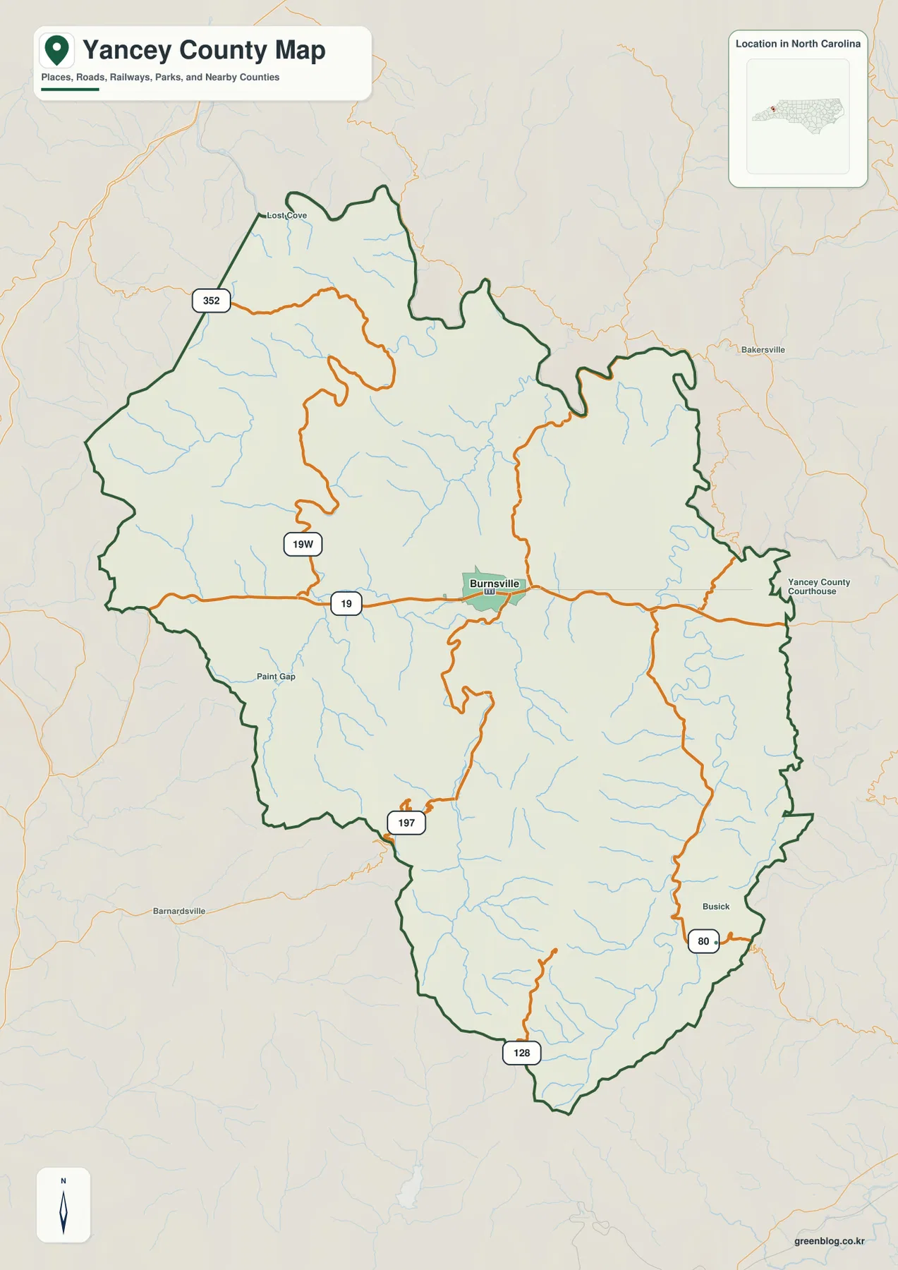
Busick appears near the southeastern boundary where routes 80 and 128 provide additional orientation. Mount Mitchell remains important in the existing page and county background, but its summit label is not printed prominently on this preview. For that reason, the map description does not pretend to show an exact summit location or elevation line from this image alone.
Micaville and Celo require the same distinction. The existing page uses them as eastern South Toe valley references, but they are not printed on the current general or city preview. They remain useful county context, especially for the eastern valley discussion, without being described as clearly labeled map cities.
Mount Mitchell above Cane and South Toe valleys
The terrain-and-water map immediately shows a county divided by steep ridges and narrow drainage valleys. Cane River is the strongest western-central water reference, while Bald Mountain Creek occupies a separate northwestern valley. Numerous smaller tributaries descend from both sides, so the Burnsville-to-western-county landscape is much more complex than a single river line.
North Toe River and South Toe River form separate eastern river corridors. The similar names can make them easy to merge mentally, but the map clearly treats them as distinct channels. South Toe River continues far south through the eastern half, while North Toe River bends through the northeast. Keeping those two rivers separate helps explain why the existing page treats Micaville and Celo as an eastern zone rather than as Burnsville suburbs.
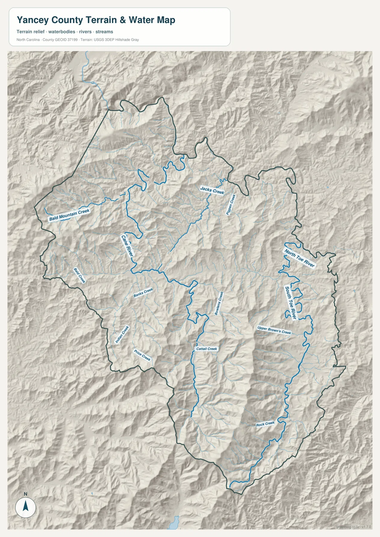
Jacks Creek occupies a long north-central valley, with Pigeon Creek farther east. Bowens Creek and Cattail Creek appear through the south-central interior, while Banks Creek, Indian Creek, and Price Creek provide western-southern references. Rock Creek marks another southeastern drainage. The map therefore shows a dense mountain stream network rather than a county defined by only two or three major waterways.
The existing page’s 6,684-foot Mount Mitchell figure remains useful high-elevation context, but that number is not printed on this preview. The shaded relief is best used to recognize relative ridge-and-valley differences and the concentration of rugged terrain, not to measure a summit or survey-grade elevation directly.
Micaville and Celo form a separate eastern zone
The city map makes Yancey County unusual compared with many larger counties: only Burnsville appears in the ranked city distribution, at 2,082. That number is the value printed on the supplied graphic, not an independently updated population estimate. The absence of other ranked cities should not be read as an absence of communities; it reflects a mountain county where smaller settlements and valleys often matter more for orientation than a municipal hierarchy.
The existing page uses Micaville and Celo to describe the eastern South Toe valley. Because neither name is printed on the current city preview, they are not treated here as ranked map locations. Instead, they remain source-backed eastern references that help distinguish Burnsville’s administrative-service role from the separate communities and river valleys farther east.
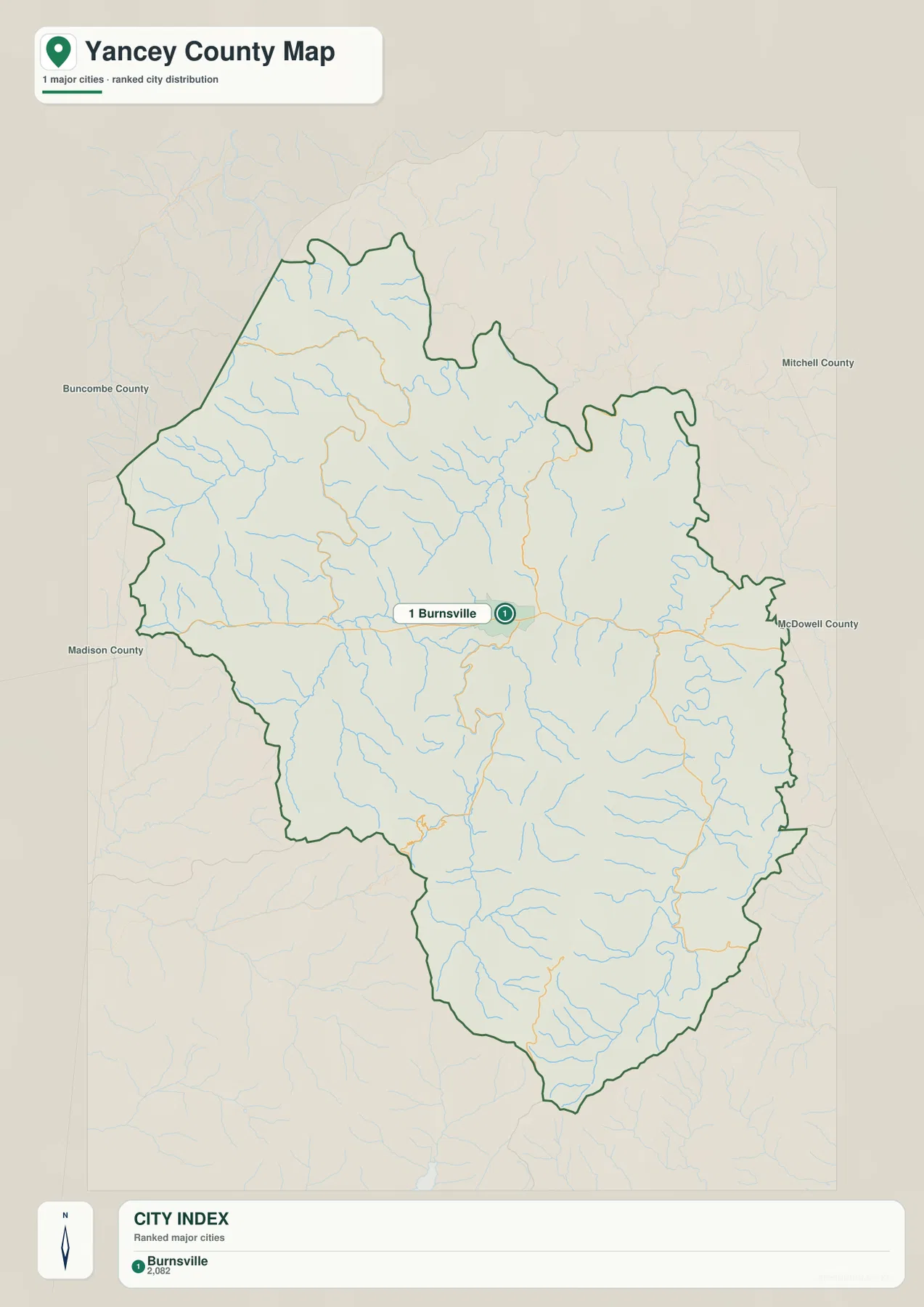
That one-city graphic makes the general and terrain maps even more important. Cane River to the west, Jacks Creek in the north-central interior, the Toe River system to the east, and Bowens, Cattail, and Rock creeks farther south cannot be explained by one city point. Roads and drainage valleys provide the practical structure for much of the county.
Bakersville and Barnardsville appear outside the county on the general map as regional context. Those labels should not be mixed with internal Yancey County settlements. The county outline, Burnsville, numbered roads, and named waterways remain the reliable internal references.
Reading high peaks, valleys, and settlements separately
A practical way to read Yancey County starts with Burnsville for administration and roads, then moves west along Cane River and the 19W-352 side, east toward the North and South Toe river corridors, north through Jacks and Pigeon creeks, and south along 197 and the Bowens-Cattail-Rock Creek valleys. That sequence keeps the county’s major mountain directions visible without forcing every outer area into a Burnsville-centered description.
Mount Mitchell is still an important county-scale high-elevation reference in the existing page, while Micaville and Celo remain useful eastern community context. Yet the current preview maps do not print those names clearly. Separating source-backed background from directly visible map labels makes the article more precise and tells readers exactly what they can verify on the map itself.
The general map is strongest for Burnsville and the mountain road network. The city graphic provides a simple picture of Burnsville’s role as the only ranked major city in this package. For Cane River, North and South Toe rivers, tributary valleys, and rugged relief, the terrain-and-water map carries the most detail.
The download archive contains three high-resolution A3 JPG files matching the Yancey County general map, city map, and terrain-and-water map. The WebP previews keep the page quick to browse, while the JPG originals are better for printing, enlargement, and document placement, especially around small tributary labels and closely packed ridges.
This Yancey County set is intended for broad place, road, river, and mountain orientation. Exact elevations, legal boundaries, surveying, flood determinations, and other technical decisions should rely on the relevant official Census, USGS, county, or other authoritative source data.
Frequently Asked Questions
How does Mount Mitchell help keep Yancey County from being read as one uniform area?
Starting with Mount Mitchell gives Burnsville and the outer communities a common geographic frame. Adding Cane River then clarifies how the county’s natural setting differs across its mapped area.
Why does the relationship between Micaville and Burnsville matter?
The two names represent different map roles rather than competing centers. Burnsville establishes administration, while Micaville adds another functional or geographic zone.
Map File Information
The ZIP contains three high-resolution A3 JPG files matching the Yancey County general map, city map, and terrain-and-water map shown on this page.
- Included Files: Three high-resolution A3 JPG maps: general county map, city map, and terrain-and-water map
- File Type: High-resolution A3 JPG files in one ZIP archive
- Intended Use: Printing, education, presentations, and map-based projects
Related Maps
- Across the Rowan County North Carolina Map
- Across the Surry County North Carolina Map
- Across the Wilkes County North Carolina Map
Sources
- Yancey County – Official Website
- U.S. Census Bureau – TIGER/Line Shapefiles
- USGS – National Hydrography
- USGS – 3D Elevation Program
The county website provides administrative and mountain background, while Census and USGS links support boundary, hydrography, and elevation-source checks. Burnsville’s printed city value, numbered roads, Cane River, North and South Toe rivers, and creek names described above are grounded in the supplied maps. Mount Mitchell, Micaville, and Celo are explicitly treated as existing-page context where the current previews do not display their labels.
Green Map creates custom-edited map images using open geographic data sources such as geoBoundaries, Natural Earth, OpenStreetMap, and government open data.
These maps are edited visual materials, not raw data files, and are provided for education, documents, presentations, and graphic reference.