Yadkin County is a rural Piedmont county where Yadkinville provides the administrative center, but Jonesville, Boonville, and East Bend give the outer county its real sense of direction. The general map shows the strongest developed footprint around Yadkinville, while the northwestern, northern, and northeastern communities remain separated by broad stretches of countryside, streams, and local roads. Yadkin River adds a physical reference that cuts across a settlement pattern that would otherwise look like four isolated town labels.
This page combines a general road-and-place map, a Yadkinville-centered city-connections view, and a terrain-and-water map showing Yadkin River, Forbush Creek, the Deep Creek branches, and smaller lakes and ponds. The WebP previews are intended for quick browsing. The map file box below provides three matching high-resolution A3 JPG files in one ZIP, which is more useful when small stream labels or rural road details need to be enlarged or printed.
Table of Contents
Four settlements give Yadkin County its basic orientation
- County seat and city-connections hub: Yadkinville
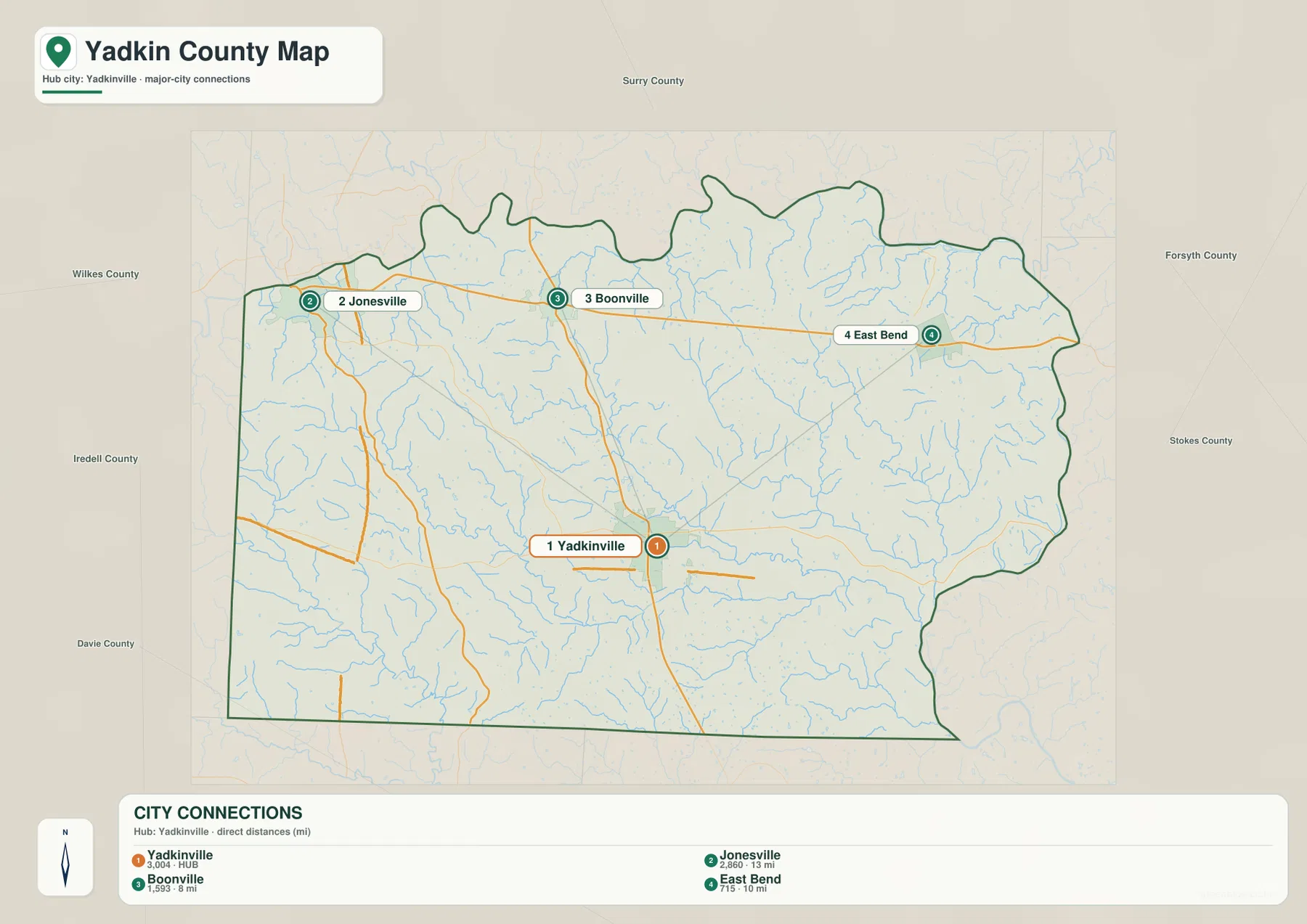
- City-map values: Yadkinville 3,004; Jonesville 2,860; Boonville 1,593; East Bend 715
- Straight-line links from Yadkinville: about 8 miles to Boonville, 10 miles to East Bend, and 13 miles to Jonesville
- Major road labels visible on the general map include 67, 421, 601, 77, and 21
- Other visible references include Smithtown, Surry Community College–Yadkin, Swan Creek Airport, and Lone Hickory Airport
- Named waterways include Yadkin River, Forbush Creek, Logan Creek, North Deep Creek, South Deep Creek, Cranberry Creek, and North-Hunting Creek
The existing page places Yadkin County within the agricultural Yadkin Valley and describes the county-managed Yadkin River Trail as an important recreation and river-access resource. That background remains useful, but this rewrite keeps exact map descriptions tied to the supplied images. The maps show the towns, roads, river, creeks, and small water bodies; they do not show every vineyard, farm boundary, or blueway access site.
Yadkinville is central, but the rural corridors point in different directions
Yadkinville sits a little south of the county’s middle and is the clearest administrative and road reference. Route 601 runs through the town toward Boonville, while route 421 crosses the southern-central part of the county. Surry Community College–Yadkin is labeled just north of the town, adding another useful reference for the central service area. The developed footprint is clear, but it remains small compared with the surrounding rural county.
Boonville lies north of Yadkinville where the north-south route meets the northern road corridor. Smithtown is farther east, and East Bend sits still farther northeast near route 67. These places do not form a continuous suburban strip. They are better treated as separate rural references that help distinguish the northern interior from the Yadkinville center.
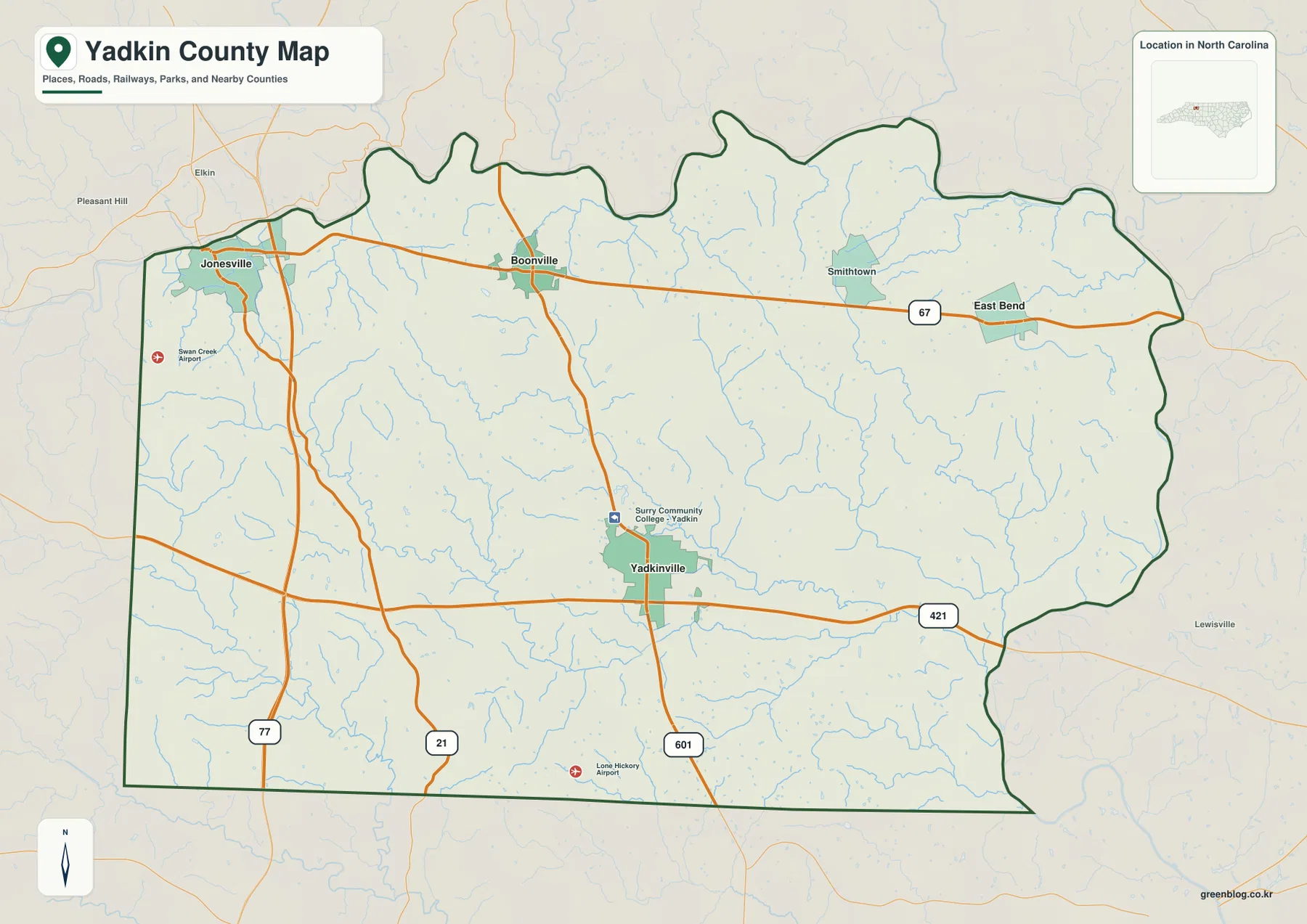
Jonesville provides the northwestern reference. Elkin appears just outside the county for regional context, while route 77 gives the western side a strong north-south road marker. Swan Creek Airport is also labeled near the Jonesville side. Keeping Jonesville separate from Yadkinville makes the county’s western rural area easier to describe without pretending that the two communities form one urban center.
The southern and southwestern sections have far fewer large settlement labels. Route 21 and local roads remain visible, and Lone Hickory Airport provides a small reference in the lower county. The wide gaps between town names are part of the geography: Yadkin County is a dispersed rural county rather than a place filled by one continuous built-up area.
Yadkin River and the Deep Creek branches define the physical map
Yadkin River is the largest named river reference on the terrain-and-water map. It provides a county-scale physical anchor that is independent of Yadkinville’s administrative importance. Once the river and tributaries are added, the broad spaces between the four main settlements become a network of low ridges, creek valleys, and drainage routes rather than blank rural land.
North Deep Creek and South Deep Creek occupy separate valleys through the central-southern part of the county. The similar names can make them easy to merge mentally, but the map shows two distinct channels. Keeping both labels visible is useful for describing the countryside south and southwest of Yadkinville.
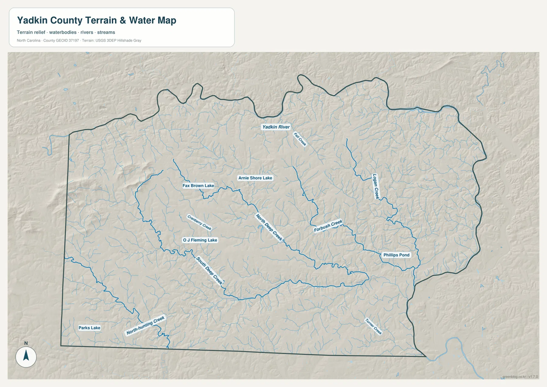
Forbush Creek is a strong central-eastern water reference, while Logan Creek lies farther northeast in another valley. Phillips Pond appears close to the eastern drainage. These features make the East Bend side easier to locate on the physical map even where settlement labels are sparse.
Cranberry Creek provides a western stream reference, and North-Hunting Creek runs near the southwestern edge. Fax Brown Lake, Arnie Shore Lake, O J Fleming Lake, and Parks Lake are scattered across separate parts of the county. They are local orientation points rather than water bodies comparable in scale to Yadkin River.
Relief is gentler than in the mountain counties farther west, but the terrain is not completely flat. Low ridges and creek valleys repeat across the county. The shaded layer is useful for broad terrain and water orientation, not for survey-grade elevation, parcel boundaries, flood determination, or water-depth analysis.
A dispersed agricultural county needs more than a town ranking
The city-connections graphic uses Yadkinville as the hub and lists four values in its lower panel: Yadkinville 3,004, Jonesville 2,860, Boonville 1,593, and East Bend 715. These figures are the values printed on this Yadkin County graphic; they are not replaced here with a separate current-population series.
Boonville is shown about 8 straight-line miles from Yadkinville, East Bend about 10 miles away, and Jonesville about 13 miles away. The straight connector lines are orientation aids only, not road mileage or mapped travel routes. The three places occupy different northern directions, so road-based travel still depends on routes 67, 601, 77, and the surrounding local network.
The existing page’s Yadkin Valley agricultural context fits this dispersed settlement pattern. Outside Yadkinville, the maps show broad rural spaces broken by creeks and local roads rather than a continuous urban surface. Agriculture is useful background here, but the supplied maps do not identify crop types, vineyard parcels, or farm ownership, so those details should not be inferred from the graphics.
Surry, Forsyth, Davie, Iredell, and Wilkes counties appear around the city-connections map as regional references. They help place Yadkin County within the broader Yadkin Valley but are not measurements of legal distance or travel time. The county outline and internal settlement points remain the useful reference for the page itself.
Use river, farm, and small-town references without mixing their roles
A practical reading order begins with Yadkinville for administration and roads, then separates Boonville to the north, East Bend to the northeast, and Jonesville to the northwest. Adding Yadkin River, the Deep Creek branches, and Forbush Creek gives the rural spaces a physical structure without turning every stream into a settlement boundary.
The official Yadkin River Trail background adds recreation and river-access context, but the county and water maps do not label every trail access point. It is therefore better to keep the trail as source-backed county context while using the river, creeks, roads, and town labels actually printed on the maps for detailed orientation.
The general map is the strongest choice for road numbers and named places. The city-connections view is useful for comparing the four settlements and their straight-line separation, while the terrain-and-water map is better for Yadkin River, Forbush Creek, Deep Creek, and the smaller lakes. Switching views by question makes a dispersed rural county easier to understand than forcing all information into one image.
The download archive contains three high-resolution A3 JPG files matching the Yadkin County general map, city-connections map, and terrain-and-water map. The WebP previews keep the page quick to browse, while the JPG originals retain more detail for printing, enlargement, and document placement, especially around small road and water labels.
For Yadkin County, this downloadable set is intended for broad place, road, stream, and terrain orientation. For Yadkin County, official boundary, flood, navigation, survey, or engineering work should be checked against the relevant Census, USGS, county, or other authoritative source rather than this reference set.
Frequently Asked Questions
What local geographic pattern becomes clearer around Yadkin River?
Yadkin River represents part of the county’s physical framework; Yadkinville, Jonesville, and East Bend represent settlement. Keeping the river framework separate from town roles prevents Yadkinville’s administrative importance from hiding physical differences across the rural county.
What additional local context does Jonesville provide?
Jonesville extends the map beyond a seat-centered description. It provides another settlement anchor for reading areas that would otherwise be represented only through Yadkinville.
Map File Information
The ZIP contains three high-resolution A3 JPG files matching the Yadkin County general map, city-connections map, and terrain-and-water map shown on this page.
- Included Files: Use only the versions confirmed in the article and supplied images
- File Type: Use the confirmed download contents
- Intended Use: Printing, education, presentations, and map-based projects
Related Maps
- Across the Rowan County North Carolina Map
- Across the Surry County North Carolina Map
- Across the Wilkes County North Carolina Map
Sources
- Yadkin County – Yadkin River Trail
- U.S. Census Bureau – TIGER/Line Shapefiles
- USGS – National Hydrography
- USGS – 3D Elevation Program
The county river-trail link provides local recreation context, while Census and USGS links support boundary, hydrography, and terrain-reference checks. City values, straight-line distances, road labels, Yadkin River, the Deep Creek branches, Forbush Creek, and smaller water labels described above are grounded in the supplied Yadkin County package.
Green Map creates custom-edited map images using open geographic data sources such as geoBoundaries, Natural Earth, OpenStreetMap, and government open data.
These maps are edited visual materials, not raw data files, and are provided for education, documents, presentations, and graphic reference.