Wilson County in eastern North Carolina has one clearly dominant urban center, but the county map is much more useful when Wilson is not allowed to stand in for every surrounding area. Elm City lies to the north, Sims to the northwest, Lucama and Black Creek to the south, and Stantonsburg to the southeast. The developed footprint shrinks quickly away from Wilson, leaving wider rural spaces where creeks, swamps, reservoirs, and smaller road corridors become stronger reference points.
This page combines a general road-and-place map, a ranked six-city distribution map, and a terrain-and-water view that highlights Contentnea Creek, Toisnot Reservoir, Town Creek, Whiteoak Swamp, and smaller water bodies. On this Wilson County page, the WebP previews are sized for quick on-page checking before opening the larger files. The map file box below provides the three matching high-resolution A3 JPG files in one ZIP, which is more useful when small stream labels or road shields need to be enlarged or printed.
Table of Contents
Six references make Wilson County easier to orient
- County seat and dominant urban reference: Wilson
- City-map values: Wilson 48,370; Elm City 1,292; Lucama 1,205; Stantonsburg 958; Black Creek 749; Sims 522
- Additional general-map place reference: Saratoga
- Major road labels include 58, 301, 42, 264A, 264, 795, 117, 587, 95, 581, 222, 91, and 111
- Named waterways include Contentnea Creek, Town Creek, Black Creek, Toisnot Swamp, and Whiteoak Swamp
- Named water bodies include Lake Wilson, Silver Lake, Toisnot Reservoir, Contentnea Lake, Wiggins Mill Reservoir, Edmunson Pond, and Archie Ellis Pond
Wilson County’s existing geography source describes a transition from gently rolling Piedmont land in the west toward a flatter Coastal Plain to the east, with Contentnea Creek as an important water reference. The supplied terrain map does not show a dramatic escarpment, so this article treats that fall-line setting as source-backed regional context rather than drawing a precise boundary that the image does not contain.
Wilson’s urban core gives way quickly to small rural towns
Wilson occupies the broadest developed area in the middle of the general map. Routes 42 and the 264 corridor provide strong east-west references, while 795 and 117 help organize the north-south direction. Wilson County Department of Health is labeled near the central urban area, reinforcing the concentration of county services around the largest city.
Elm City sits well north of Wilson and has its own developed footprint near route 301. The Elm City Police Department is labeled separately, and Sharpsburg appears beyond the county boundary as outside context. Keeping Elm City distinct from Wilson makes the northern rural gap much easier to see than a simple center-and-suburb description would.
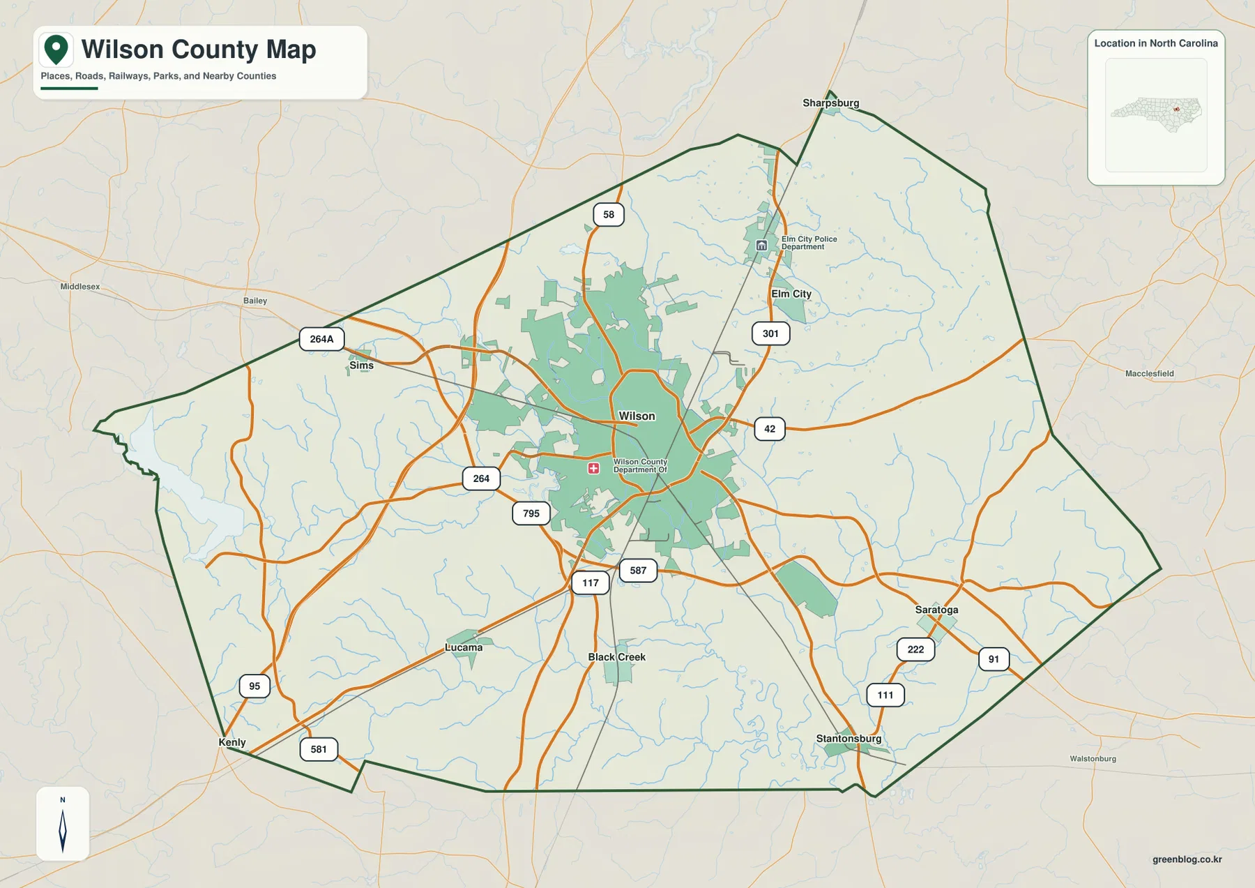
Lucama provides the clearest southwestern reference. Routes 117 and 581 help locate that side, with Kenly visible outside the county farther south. Black Creek lies east of Lucama in another small settlement area, showing that the southern county is divided among several rural places rather than organized around one secondary town.
Stantonsburg marks the southeastern side, with Saratoga farther north and east. Routes 222, 91, and 111 help separate this part of the county from Wilson’s denser road network. The developed shading becomes noticeably smaller here, which is one of the clearest map-based signs that Wilson County combines a strong central city with a much broader rural exterior.
Contentnea Creek and the Toisnot system organize the lowlands
Contentnea Creek is the most prominent long waterway across the southern part of the terrain map. It enters from the west, continues toward the southeast, and gathers a network of smaller tributaries. Wilson may dominate the settlement map, but Contentnea Creek provides a separate physical reference for the rural southern half of the county.
Lake Wilson and Silver Lake sit north of the center, with Toisnot Reservoir farther south. Toisnot Swamp extends through the central-eastern lowland and is very different in shape from the compact reservoir water bodies. Treating those features separately helps the terrain map remain useful rather than turning every blue label into the same kind of lake reference.
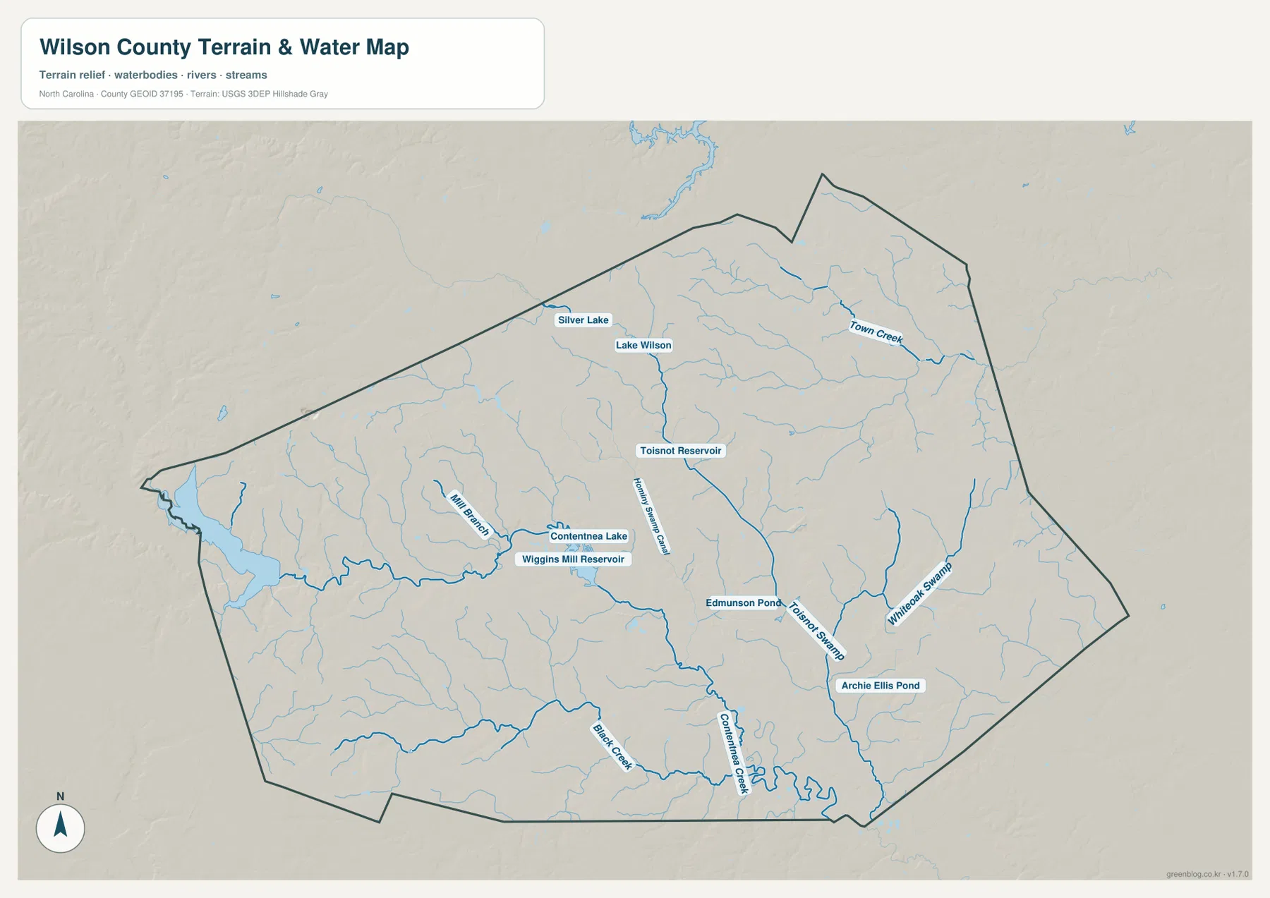
Town Creek runs through the northeastern interior, while Whiteoak Swamp provides a long eastern water reference. Mill Branch appears farther west, and Black Creek is labeled in the southern half near the broader Contentnea system. These channels divide the rural landscape independently of city boundaries and are particularly useful in areas where settlement labels are sparse.
Contentnea Lake and Wiggins Mill Reservoir provide local references in the central-southwestern area, while Edmunson Pond and Archie Ellis Pond help locate smaller eastern sections. None of these water bodies matches a large regional lake in scale. Their value is local: they help distinguish individual creek corridors and lowland areas within a county where flowing water and swamp features are more common than broad open water.
The western Piedmont becomes flatter toward the east
Wilson County’s official geography material describes a west-to-east transition from gently rolling Piedmont terrain toward flatter Coastal Plain land. On the terrain image, the change is subtle rather than dramatic. The western side shows slightly more relief and small stream valleys, while the eastern half is dominated by broad low ground crossed by creeks and swamp corridors.
The settlement map supports that reading in another way. Sims and Lucama sit within more open western and southwestern countryside, while Stantonsburg and Saratoga occupy a flatter-looking eastern landscape with long stretches between developed areas. The difference is easier to understand when road density, stream networks, and settlement spacing are considered together rather than relying on a single elevation claim.
This shaded terrain layer should not be used to draw an exact fall-line boundary or to read survey-grade elevations. It is appropriate for broad relative relief and water orientation only. Precise elevation, slope, flood hazard, or parcel decisions require the underlying official data rather than the simplified county preview.
City ranking is useful only when location stays visible
The city-distribution map makes Wilson’s scale advantage immediately obvious. Wilson is first at 48,370, followed by Elm City at 1,292 and Lucama at 1,205. Stantonsburg is fourth at 958, Black Creek fifth at 749, and Sims sixth at 522. These figures are the values printed on the supplied Wilson County city graphic; they are not substituted with a separate current-population series.
The map positions matter as much as the ranking. Elm City is north, Sims northwest, Lucama and Black Creek south, and Stantonsburg southeast. Those locations show that the five smaller ranked places are not a compact ring of suburbs around Wilson; they are rural town references spread across different parts of the county.
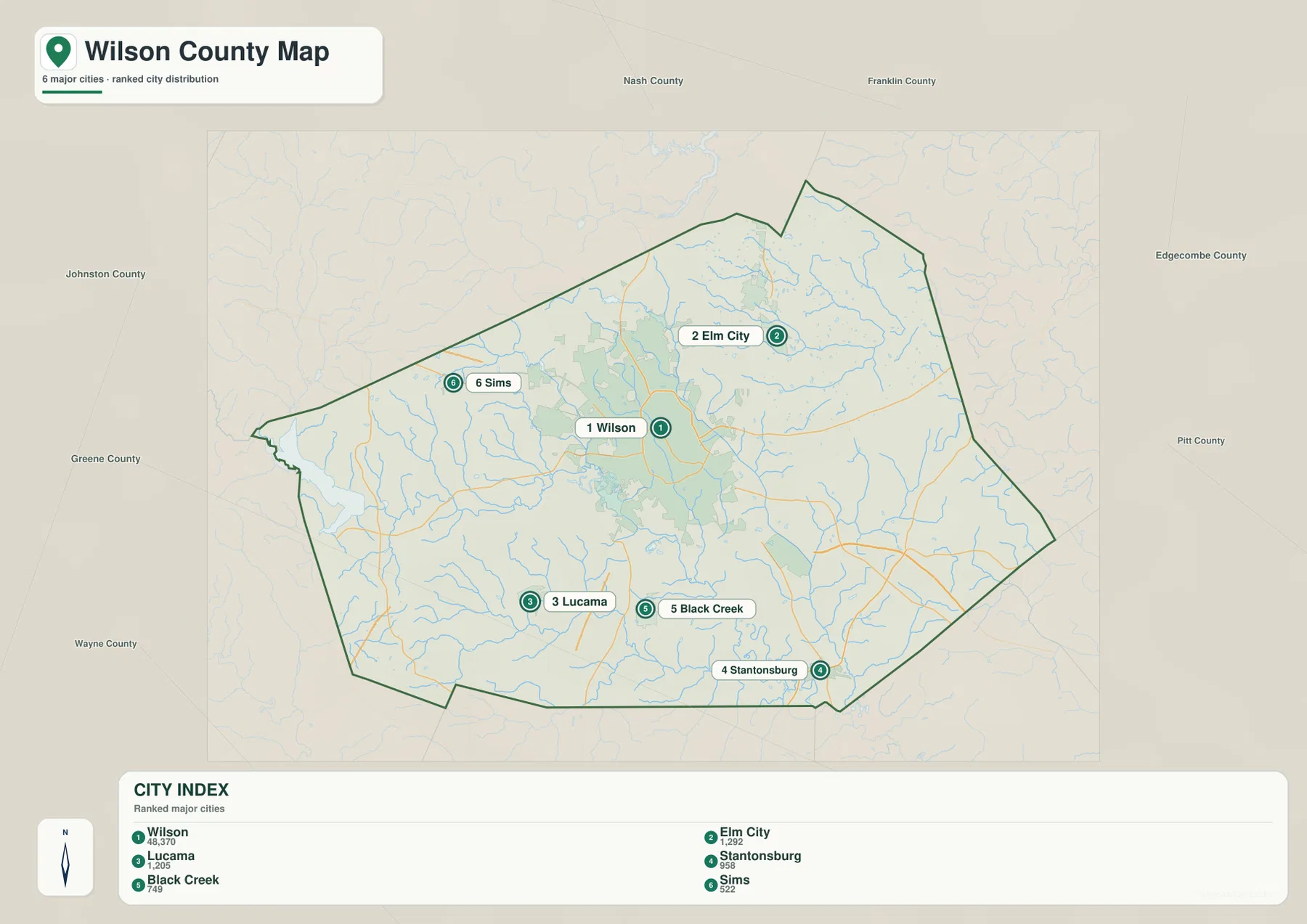
For road numbers and place names, the general map is the strongest choice. The city map makes settlement scale and distribution easier to compare, while the terrain-and-water view is better for Contentnea Creek, Toisnot Reservoir, Town Creek, and Whiteoak Swamp. Switching views by question preserves the difference between Wilson’s urban dominance and the geography of the surrounding countryside.
The download archive contains three high-resolution A3 JPG files matching the Wilson County general map, city-distribution map, and terrain-and-water map. For close inspection of small road shields and water labels, the JPG originals preserve more usable detail than the lighter WebP previews.
Frequently Asked Questions
Why is Contentnea Creek a useful reference beyond Wilson city?
Contentnea Creek gives the southern and southeastern county a physical anchor that does not depend on Wilson’s urban size. Read together with Lucama, Stantonsburg, and the smaller road network, it helps explain the lowland countryside that would otherwise disappear behind a city-centered description.
Why should Elm City stay separate from Wilson on the map?
Elm City lies north of Wilson near route 301 and represents a different part of the county’s rural settlement pattern. Keeping the two places separate preserves the visible gap between the central urban core and the northern countryside.
Map File Information
The ZIP contains three high-resolution A3 JPG files matching the Wilson County general map, city-distribution map, and terrain-and-water map shown on this page.
- Included Files: Use only the versions confirmed in the article and supplied images
- File Type: Use the confirmed download contents
- Intended Use: Printing, education, presentations, and map-based projects
Related Maps
- Across the Rowan County North Carolina Map
- Across the Surry County North Carolina Map
- Across the Wilkes County North Carolina Map
Sources
- Wilson County – Geography
- U.S. Census Bureau – TIGER/Line Shapefiles
- USGS – National Hydrography
- USGS – 3D Elevation Program
The county geography source provides the Piedmont-to-Coastal Plain background used here, while Census and USGS links support boundary, hydrography, and terrain-reference checks. City values, road labels, Contentnea Creek, Toisnot Reservoir, Town Creek, Whiteoak Swamp, and the smaller named water bodies described above are grounded in the supplied Wilson County package.
Green Map creates custom-edited map images using open geographic data sources such as geoBoundaries, Natural Earth, OpenStreetMap, and government open data.
These maps are edited visual materials, not raw data files, and are provided for education, documents, presentations, and graphic reference.