Stanley County occupies a broad stretch of central South Dakota west of the Missouri River, where open prairie is broken by reservoir shoreline, creek valleys, and steadily higher ground toward the interior. Fort Pierre sits at the eastern edge directly across the river from Pierre, while Lake Oahe shapes the northeastern boundary and the Bad River approaches the Missouri from the southwest. This page brings those features together with a county reference map, city distribution map, terrain and water map, and elevation map. High-resolution JPG versions of all four maps are also available in a ZIP download, so visitors who arrive looking for printable Stanley County map files can get them without searching through the article first.
Fort Pierre is the easiest place to begin. It is the county seat and the only incorporated town identified by Stanley County’s official information, yet it occupies only a small part of a county that covers about 1,521 square miles. West of town, the map quickly becomes less about city labels and more about roads, creeks, and relief. SD 34 and US 14 provide a strong east-west reference, US 83 runs south from the Fort Pierre area, SD 63 marks part of the western side, and SD 204 appears near the Lake Oahe side of the county.
The maps are most useful when they are read as views of the same landscape rather than as four unrelated products. The general map establishes roads, boundaries, and place names. The city layer shows how strongly settlement is concentrated near Fort Pierre. The water layer reveals how the Missouri, reservoirs, Bad River, and smaller creeks divide the prairie, while the elevation map shows that those watercourses occupy lower corridors cut into higher western ground. The sections below follow that geographic story from the river edge into the interior.
Table of Contents
Begin at Fort Pierre, Where the County Meets the Missouri
The eastern boundary is the first feature that distinguishes Stanley County on the reference map. The west and south sides contain long, relatively straight county lines, but the Missouri River system produces a much more complicated edge on the east. Lake Oahe widens north of Fort Pierre, pushing coves and reservoir arms into the boundary. South of Fort Pierre the river continues toward Lake Sharpe, and the county develops a long southeastern extension along the water. Following that shoreline explains the county outline more clearly than memorizing the names of neighboring counties.
Fort Pierre lies near the point where several road references and river features come together. Pierre is visible immediately across the Missouri, which makes the map especially useful for distinguishing the two cities and the county line between them. SD 34 and US 14 head west from the Fort Pierre area, US 83 runs south, and SD 204 is shown curving toward the north and northeast. Farther west, SD 63 provides another useful locator along the county’s outer side. In a sparsely settled county, these road shields are often more practical orientation points than town names.
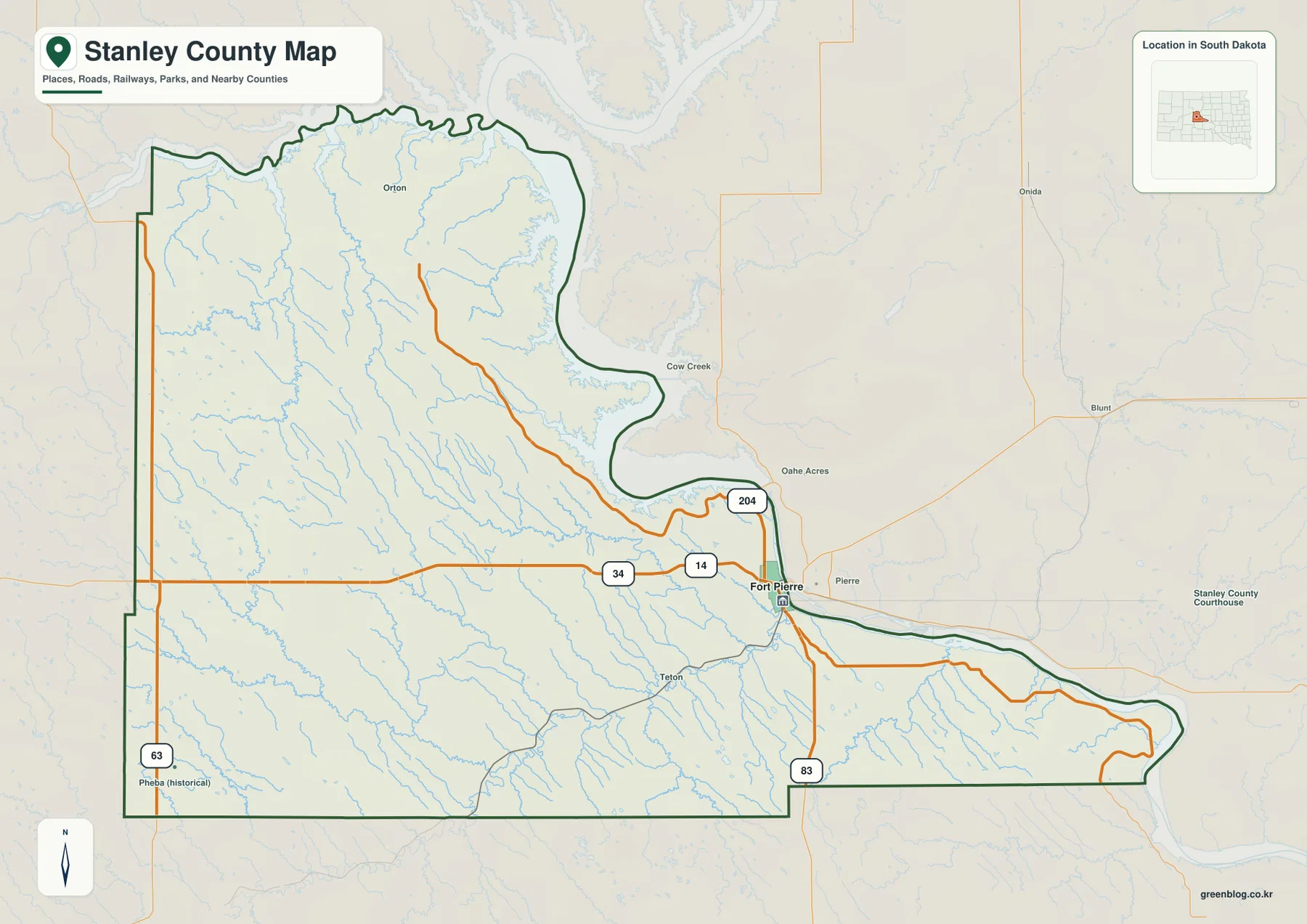
Several smaller names appear inside the boundary, including Orton, Teton, and Pheba. These labels are useful for orientation, but they should not all be read as present-day incorporated communities. Pheba, for example, is explicitly marked as historical on the supplied map. The map is therefore best used to understand geographic position rather than to determine current municipal status, street-level navigation, or legal property boundaries. Road closures, parcel lines, and access conditions should always be checked with a current source when those details matter.
Sparse Settlement Makes Roads More Important Than City Labels
The city distribution map makes Stanley County’s settlement pattern immediately clear. Its CITY INDEX contains one major-city entry: Fort Pierre, with a displayed value of 2,410. The map does not provide a reference year for that number, so it should not be treated as a current population estimate. What it does show reliably is the visual contrast between the populated eastern edge and the very broad western and northern interior, where no comparable city marker appears.
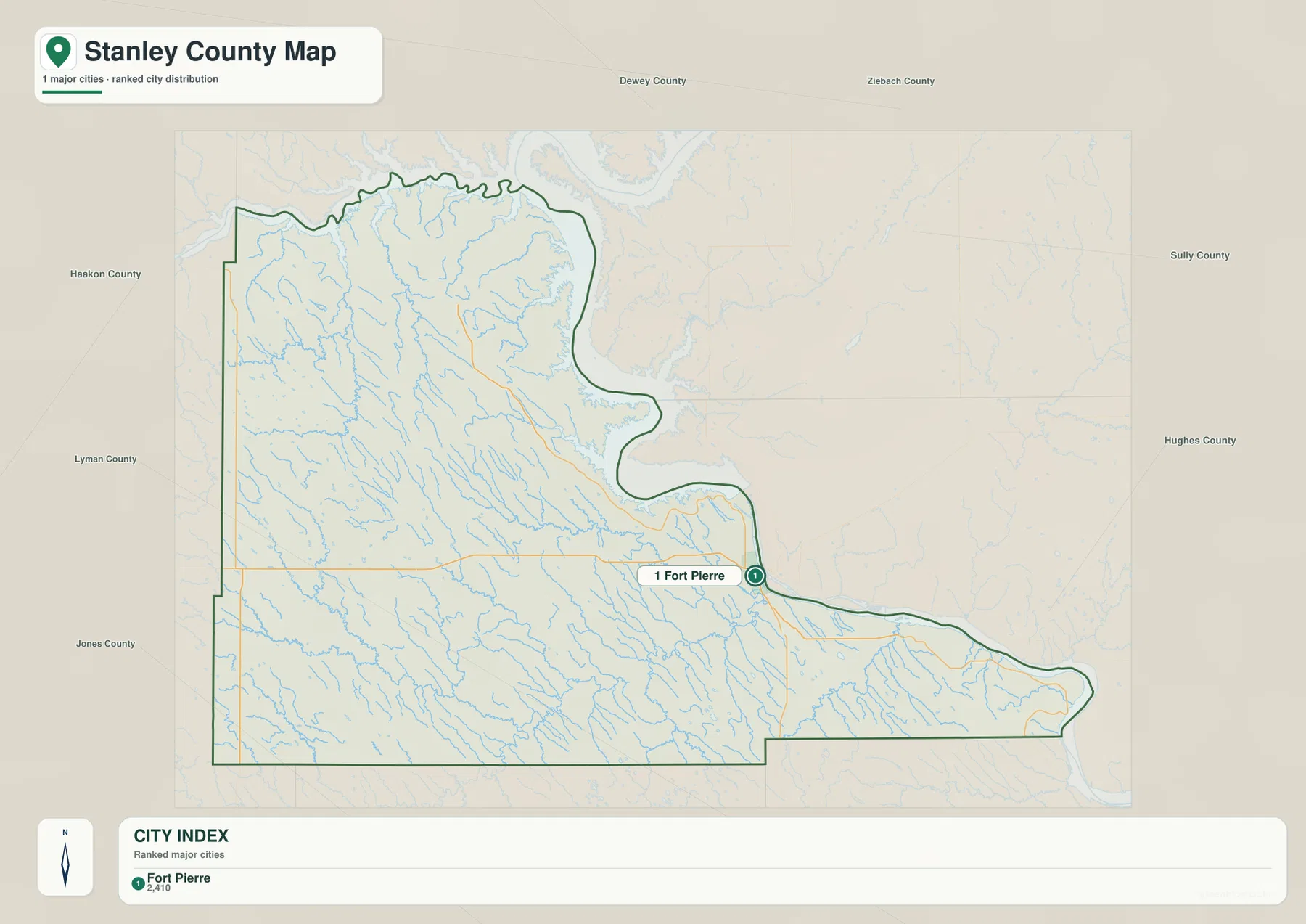
The surrounding county labels help place Stanley County within central South Dakota. Dewey and Ziebach counties appear to the north, Haakon lies to the west, and Lyman and Jones are shown to the southwest and south. Across the river, Sully and Hughes counties provide eastern reference points. Pierre is especially important because it is close enough to appear almost attached to Fort Pierre on a small-scale map, but the Missouri River and county boundary separate the two. Keeping the boundary line in view prevents an easy geographic mistake.
Once the view shifts west, the road network becomes the more useful guide. SD 34 provides a long east-west reference across the middle of the county, and SD 63 helps locate the far western side. In the south, US 83 and the Bad River system give a different pair of landmarks. This is why the general and city maps work best together: the city layer explains where settlement is concentrated, while the road layer gives the reader enough structure to navigate a large rural area that has relatively few prominent place labels.
Waterways Carve the Prairie from Lake Oahe to Bad River
The terrain and water map changes the way the county looks. Lake Oahe dominates the northeast, while the Missouri River continues past Fort Pierre and toward Lake Sharpe along the southeastern edge. The Bad River approaches from the interior and joins the Missouri near Fort Pierre. Those large water features are easy to notice, but the smaller streams are just as important for understanding why the interior terrain is so deeply divided.
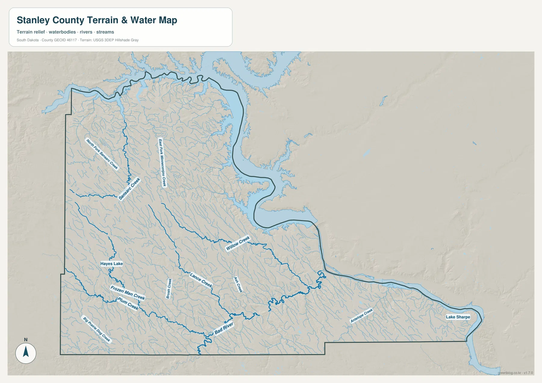
In the northwest, Sansarc Creek and North Fork Sansarc Creek form distinct branching corridors, with East Fork Rattlesnake Creek farther east. Willow Creek crosses the central part of the county toward the Missouri side, while Lance Creek and several other tributaries occupy the southern half. Hayes Lake provides a small but useful water landmark in the southwest. These features turn what might seem like an undifferentiated prairie on a simple road map into a landscape of repeated valleys and drainage lines.
Comparing the water and road maps is useful because the two networks behave very differently. Highways often run in long, relatively direct segments, but creeks bend around local relief and divide into numerous branches. In western Stanley County, where city labels are sparse, those creek valleys help explain the shape of the land around the roads. Farther east, the smaller drainages converge toward the broader Missouri River system and the lower ground around Fort Pierre.
The blue lines should still be read as a geographic reference rather than a statement about current water conditions. A wider symbol does not necessarily mean a stream carries more water throughout the year, and reservoir levels can change. The map does not show flood forecasts, water quality, navigability, or present boating conditions. For those uses, current agency information is necessary. Here the purpose is simpler: identify where the major water bodies and drainage corridors sit within the county and how they relate to the surrounding terrain.
Elevation Shows the Long Rise Away from the River
The elevation map gives Stanley County a much stronger three-dimensional character. Its legend reports an actual county range of roughly 433 to 725 meters, with a mean near 571 meters. Green colors follow the lower Missouri River, Lake Oahe, Bad River, and many creek valleys. Tan and brown become much more common across the west and southwest, showing that the interior prairie stands considerably higher than the river edge.
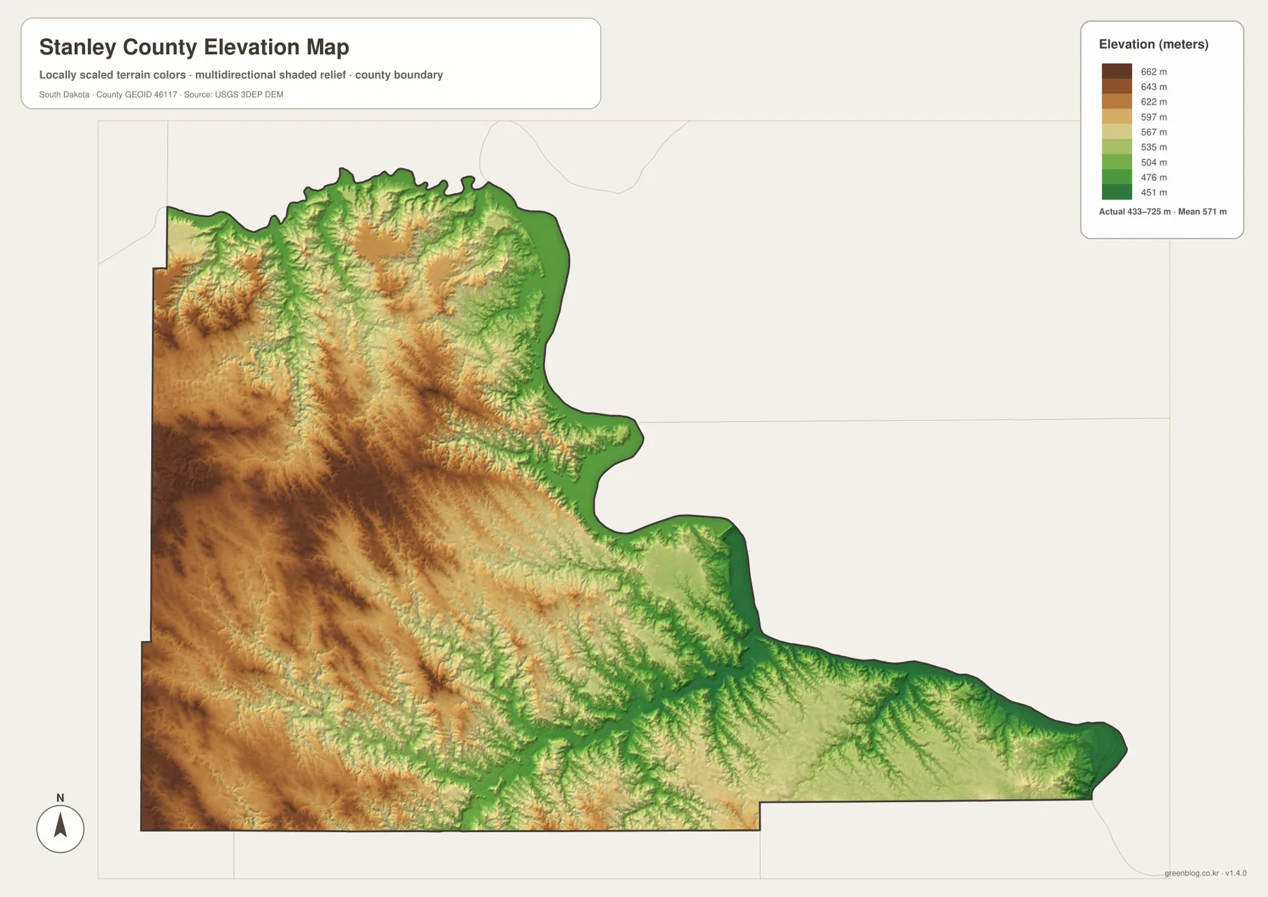
The high ground is not a single smooth plateau. In the northwest, branching valleys cut through ridges and leave alternating bands of higher and lower terrain. Similar low fingers extend into the center and south where tributaries approach the Bad River. When Sansarc Creek, Willow Creek, Lance Creek, and the Bad River are located on the water map and then matched to the elevation image, their paths line up with many of the greener, lower corridors. The two maps reinforce each other without requiring technical GIS analysis.
The eastern part of the county has a different appearance. Lower colors become more continuous near Lake Oahe and the Missouri, and the Fort Pierre area sits close to the broad river corridor. The Bad River valley also creates a lower route into the county from the east. This does not mean the entire county simply slopes in one direction. Higher prairie surfaces are repeatedly interrupted by creek-cut valleys, so local relief remains visible well away from the main river.
The elevation colors are generalized for county-scale comparison. The 433–725 meter range describes the surface represented across the map, but it is not a substitute for a survey reading at a house, road, bridge, or construction site. Engineering, drainage design, and legal surveying require a more precise elevation source such as an appropriate DEM or field measurement. For general map reading, however, the image clearly explains why the Missouri edge is lower and why the western interior looks more dissected and elevated.
Choosing the Right Map for Print, Reference, and Classroom Use
The general county map is the best starting point when the goal is to show Fort Pierre, major highways, neighboring areas, and the boundary in one image. The city map is more focused and works well when a reader needs to explain how strongly settlement is concentrated at the eastern edge. The terrain and water map is the clearer choice for Lake Oahe, Lake Sharpe, Bad River, and the interior creek network. The elevation map is most useful when the question is why the west and southwest stand higher than the Missouri corridor.
A classroom or presentation can also use the maps as a sequence. Locate Fort Pierre and the road network first, switch to the city map to see settlement concentration, then follow the Missouri and Bad River on the water layer. The elevation image completes the comparison by showing the lower green river corridors against the higher western prairie. The same approach works in the west: establish position from SD 34 or SD 63, find a nearby creek such as Sansarc Creek, and then compare that valley with the surrounding uplands.
The downloadable JPG files are larger than the on-page previews and are intended for closer inspection, A3 printing, handouts, presentations, and personal reference. They should not be treated as real-time operational maps. Construction, road closures, reservoir levels, property ownership, and access restrictions can change independently of these images. When one of those details affects a trip or project, use a current official source alongside the map.
Frequently Asked Questions
Are Fort Pierre and Pierre in the same county?
No. On the supplied map, Fort Pierre is on the west side of the Missouri River within Stanley County, while Pierre is across the river to the east in Hughes County. The cities are close together, so keeping the river and county boundary visible is the easiest way to distinguish their locations.
Why is Fort Pierre the only major city shown in the CITY INDEX?
The supplied city map contains a single major-city entry for Fort Pierre, and Stanley County’s official information also identifies Fort Pierre as the county’s only incorporated town. The value 2,410 appears beside the city in the map index, but no reference year is printed, so it should be treated as part of the map’s ranking display rather than a current population figure.
Can the 433–725 meter elevation range be used for site measurements?
Not for precise site work. The elevation map reports a countywide range of about 433–725 meters and a mean near 571 meters, which is useful for comparing the lower Missouri and Bad River corridors with the higher western interior. A particular property, road grade, or construction site requires a finer DEM or a professional survey if accurate elevation is important.
Map File Information
The ZIP contains the high-resolution JPG originals for the Stanley County reference map, city distribution map, terrain and water map, and elevation map shown on this page. Each JPG is 2572×3638 pixels and is suitable for A3 printing and detailed viewing.
- Included Files: 4 high-resolution maps
- File Type: JPG
Related Maps
Sources and References
- Stanley County Government – About Stanley County – Official county background covering Fort Pierre, county size, settlement, and local history.
- U.S. Census Bureau TIGER/Line Shapefiles – Official geographic data for county boundaries, roads, and related map layers.
- USGS National Hydrography – Official reference for rivers, streams, lakes, and hydrographic datasets.
- USGS 3D Elevation Program – Official elevation and DEM resources for more detailed height information.
Green Map creates custom-edited map images using open geographic data sources such as geoBoundaries, Natural Earth, OpenStreetMap, and government open data.
These maps are edited visual materials, not raw data files, and are provided for education, documents, presentations, and graphic reference.