Catoosa County sits at the northwestern edge of Georgia, directly below the Tennessee state line and within easy reach of Chattanooga. Although the county is compact, its maps contain a lot of geographic detail: Ringgold and Fort Oglethorpe occupy different parts of the county, I-75 cuts through the central transportation corridor, Chickamauga streams spread through the valleys, and long ridges run northeast to southwest. The four maps on this page separate those features so each one is easier to see.
You can also download the four maps as a ZIP containing the original high-resolution JPG files. They are useful for printed reference sheets, classroom work, presentations, and county-to-county comparisons. The page is intended as a clear geographic guide rather than a substitute for parcel mapping, turn-by-turn navigation, flood-zone determinations, or engineering survey data.
Table of Contents
Catoosa County Boundary, Ringgold, and the Main Road Network
The county map gives the broadest view. Catoosa meets Hamilton County, Tennessee, along its northern edge, Walker County on the west, and Whitfield County on the east and south. The map places Ringgold near the center, Fort Oglethorpe near the western side, and smaller labeled places such as Lakeview and Indian Springs farther north. Seeing the county outline together with those labels makes it clear how close northern Catoosa is to the Tennessee border and the Chattanooga area.
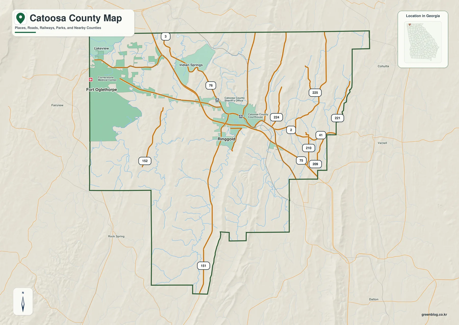
I-75 passes east of Ringgold and provides the most obvious north-south route toward Chattanooga and Dalton. US 41/76 follows the older town-and-rail corridor through Ringgold, while GA 2 runs across the northern part of the county toward Fort Oglethorpe. The map also labels routes 151, 152, 209, 210, 221, 224, and 225. Together they show that travel does not spread evenly across the county; roads concentrate in valleys and in the lower passages between the parallel ridges.
Ringgold is the county seat, and the map includes the Catoosa County Courthouse and Sheriff’s Office in the central area. Fort Oglethorpe is closer to the western boundary, where the county map also shows developed areas, medical facilities, and green space. The map is detailed enough for regional orientation, but it does not provide parcel lines, municipal limits, lane-level road information, or survey boundaries. Those tasks require current county or municipal GIS data.
| State / FIPS | Georgia / 13047 |
|---|---|
| County seat | Ringgold |
| Created | 1853 |
| Incorporated cities | Ringgold and Fort Oglethorpe |
| 2020 population | 67,872 |
| 2025 population estimate | 69,628 |
| Land area | 162.16 square miles |
| Main roads | I-75, US 41/76, GA 2 |
| Water features | South Chickamauga, Little Chickamauga, Peavine, Tiger, and other creeks |
Ringgold and Fort Oglethorpe on the City Distribution Map
The city map strips away many of the smaller labels and highlights the county’s two major incorporated cities. Fort Oglethorpe is ranked first at 10,416 on the map, while Ringgold is second at 3,435. The important point is not only the ranking. Fort Oglethorpe sits near the western county edge, whereas Ringgold occupies a more central position where several transportation routes converge. That contrast is much easier to see here than on a crowded road map.
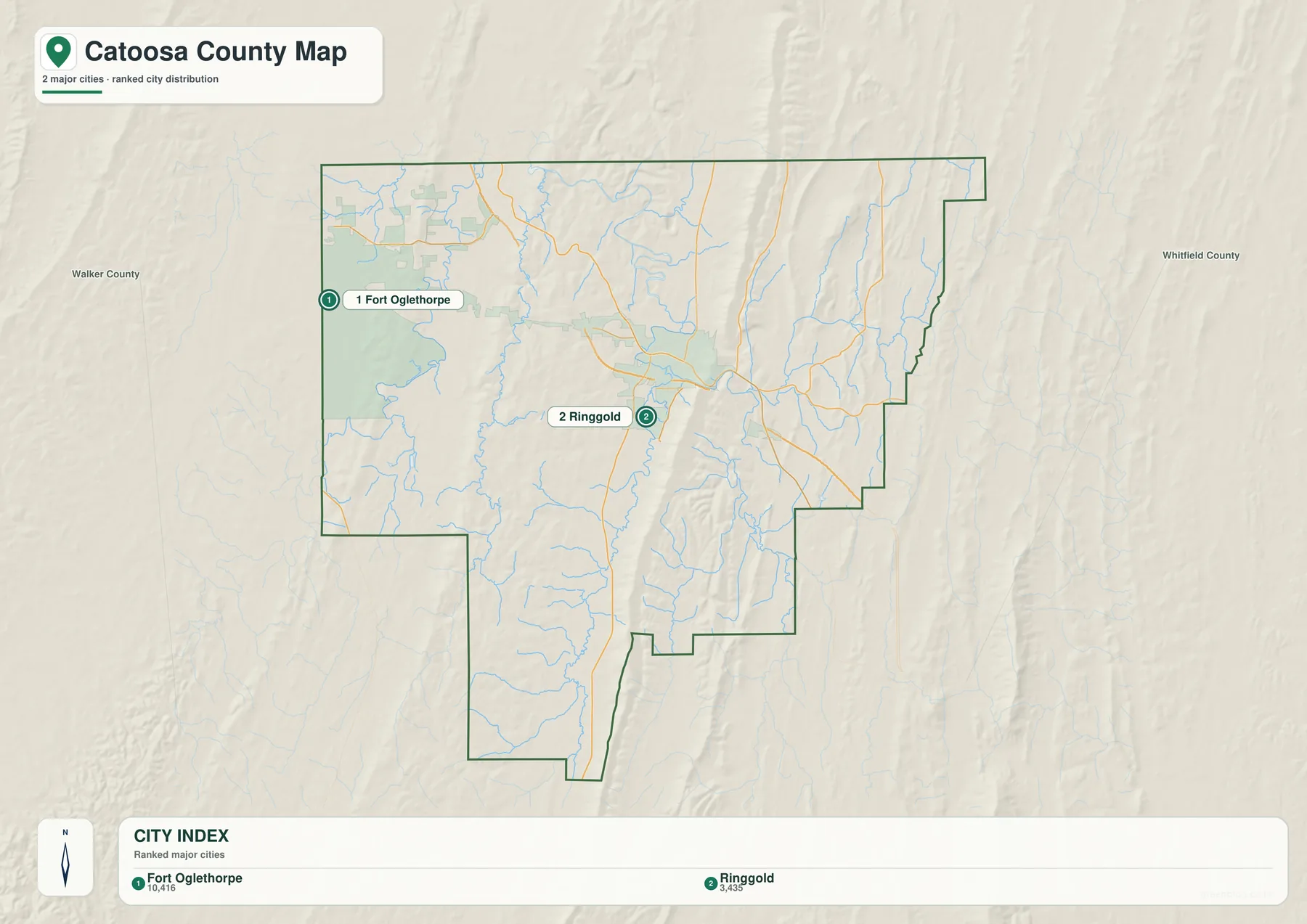
Ringgold’s location makes more sense when the city map is compared with the elevation surface. The supplied county material places Ringgold at Ringgold Gap, a lower passage between White Oak Mountain and the continuation toward Taylor Ridge. The Western and Atlantic Railroad used this corridor, and modern routes still take advantage of the same opening through the Ridge and Valley terrain. I-75 runs just east of town, while US 41/76 stays closer to the historic town and rail alignment.
Fort Oglethorpe is closer to Tennessee and the Chickamauga battlefield area. Its municipal area is not confined entirely to Catoosa County; the supplied Georgia DCA reference records portions of the city in both Catoosa and Walker counties. For that reason, the marker is best treated as a city locator rather than an exact municipal-boundary graphic. Anyone working with addresses, zoning, or city services should consult an official boundary layer.
The two-city view is especially useful for explaining how a small county can have more than one orientation. Ringgold is tied closely to the I-75 and US 41/76 corridor through the center, while Fort Oglethorpe faces westward toward GA 2 and the national military park area. Both connect north toward the Chattanooga region, but they occupy different valleys and approach the county’s ridge system from different sides.
Chickamauga Creeks and the Valley Drainage Pattern
The water map shifts attention away from roads and toward the network of streams. South Chickamauga Creek is labeled through the central part of the county, with Little Chickamauga Creek joining the broader system. East Chickamauga Creek, Tiger Creek, Sugar Creek, Little Creek, and Dry Creek appear on the eastern side, while Chickamauga Creek and Peavine Creek occupy the west. Lake Winnepesaukah and Greenfield Lake are also labeled near the northwestern part of the map.
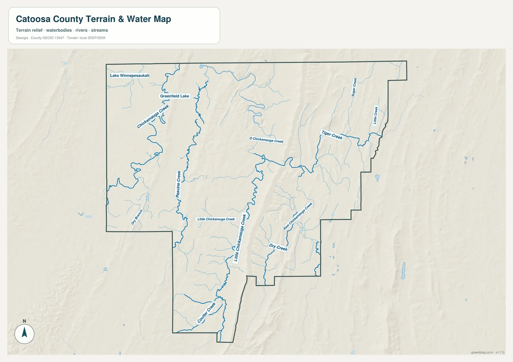
The water network is easier to understand when the relief underneath it is visible. Streams tend to occupy the lower ground between the long ridges instead of crossing the highest terrain directly. South Chickamauga Creek gathers water around the Ringgold area and continues northwest, and the supplied references include a USGS stream gauge at Ringgold. On the western side, Chickamauga and Peavine creeks help define the lower terrain near Fort Oglethorpe.
This is a hydrographic reference map, not a flood-risk product. A blue creek line shows the mapped watercourse and its relationship to the terrain; it does not identify a regulatory floodplain, predict future flooding, or establish risk for a particular building. Property-level flood questions need current FEMA flood maps and local emergency-management information. The same caution applies to navigation: the map is useful for geographic context, not for boating or field routing.
Ridge and Valley Relief from 162 to 436 Meters
The elevation map makes Catoosa’s landform pattern unmistakable. The county lies in the Appalachian Ridge and Valley region, where narrow, elongated ridges alternate with lower valleys on a northeast-to-southwest trend. The supplied elevation graphic reports an actual range of about 162 to 436 meters and a mean of 259 meters. Those numbers are useful, but the shape of the terrain is even more informative: several high, narrow ridges extend for long distances through the central and eastern parts of the county.
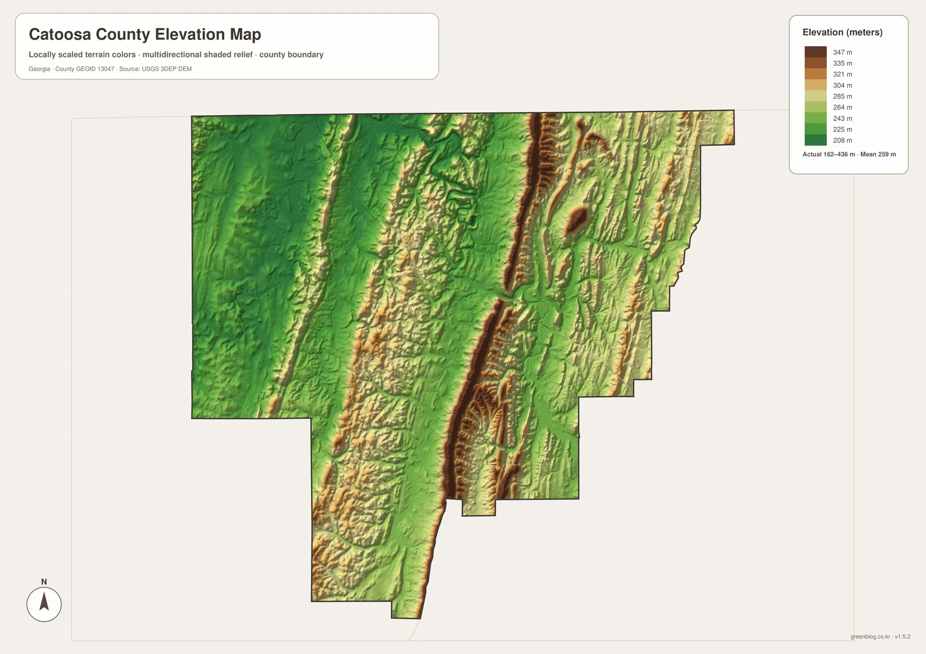
The strongest ridges appear as narrow bands of higher color, with greener lowlands immediately beside them. That arrangement helps explain why roads and streams repeatedly follow the same general corridors. Ringgold occupies a lower passage through the ridge system, and the road map shows major routes using the easier terrain nearby. Comparing the elevation and water maps also shows why many creeks run lengthwise through valleys before turning toward larger channels.
The elevation layer is generalized for county-scale viewing. It should not be treated as a survey, engineering contour map, or a precise measurement for an individual parcel. For a reader trying to understand the county, however, it adds something the road map cannot: it shows why seemingly short straight-line distances can cross substantial ridges and why settlement and transportation are concentrated in particular low corridors.
How the Terrain Connects with Catoosa County’s Local History
Catoosa County was created in 1853 from parts of Walker and Whitfield counties and is identified in the supplied county material as Georgia’s 100th county. Its name came from Catoosa Springs. The present county is relatively small, and its northern boundary lies directly against Tennessee, so its geography has always been influenced by routes moving between Georgia and the Chattanooga area rather than by an isolated county center.
Ringgold incorporated in 1847, and the Western and Atlantic Railroad reached the town in 1849. The supplied historical material also points to the 1863 Battle of Ringgold Gap, emphasizing the strategic value of this opening through the ridges. Modern I-75 and US 41/76 continue the north-south travel pattern in a different form. Looking at the county map and elevation map together gives a straightforward geographic explanation for why this corridor remained important across very different periods.
Fort Oglethorpe grew from Chickamauga Post, a military installation established in 1902, and became an incorporated civilian city in 1949 after the post closed. The visitor center for Chickamauga and Chattanooga National Military Park is in Fort Oglethorpe. On the county map, GA 2 links this western area back toward I-75, so the city serves as a useful reference point for both the park landscape and the western side of Catoosa County.
The supplied material also notes the EF4 tornado that crossed Ringgold toward Tennessee on April 27, 2011. That event is relevant here mainly as a reminder that a terrain map and a hazard map are different products. The county maps can establish where Ringgold, major roads, ridges, and streams are located, but evacuation routes, warning polygons, and current hazard zones must come from emergency and weather agencies.
Choosing the Best Catoosa Map for Your Task
Start with the county map when you need boundaries, nearby places, and the main road network on one page. The city map is cleaner when the goal is simply to place Ringgold and Fort Oglethorpe within the county. The water map is the better choice for identifying named creeks and seeing how they occupy the valleys, while the elevation map is most useful for explaining the long ridge system and the differences between higher and lower ground.
- Use the county map for a classroom overview of northwestern Georgia and the Tennessee border.
- Use the city map when comparing Ringgold’s central position with Fort Oglethorpe on the western side.
- Use the water map to locate South Chickamauga Creek, Little Chickamauga Creek, Peavine Creek, and smaller tributaries.
- Use the elevation map to explain why ridges, valleys, roads, and streams tend to share the same northeast-southwest orientation.
- For parcel, zoning, flood, construction, or route decisions, move from these overview maps to the appropriate current official dataset.
For field travel, pair the maps with current route information. For legal boundaries or land decisions, use official county and municipal GIS. Water and elevation layers are best treated as regional references unless a project specifically calls for current hydrologic, flood, or survey-grade data.
Frequently Asked Questions
Why does the city map emphasize only Fort Oglethorpe and Ringgold?
The supplied city map ranks and labels the county’s two major incorporated cities so their positions are easy to compare. Fort Oglethorpe is shown on the western side and Ringgold closer to the center. It is not intended to label every unincorporated community or reproduce exact municipal boundaries.
Is all of Fort Oglethorpe inside Catoosa County?
No. The Georgia DCA material supplied with the package records portions of Fort Oglethorpe in both Catoosa and Walker counties. Use an official city or county boundary layer when a precise municipal limit is required.
Can the water map be used to determine flood risk?
No. It identifies streams and their relationship to the terrain, but it does not show regulatory flood zones or property-level risk. FEMA flood maps and current local emergency information are the appropriate sources for that purpose.
Map File Information
High-Resolution Catoosa County Map Files
- Included Versions: county, city, water, and elevation
Related Maps
Sources and Reference Data
The county statistics, local background, roads, waterways, and elevation discussion above are based on the supplied maps and the following linked references. For decisions that depend on exact current values or boundaries, check the newest version from the responsible agency.
- U.S. Census Bureau QuickFacts for Catoosa County – population and land-area reference
- Georgia DOT Catoosa County map – county road and location reference
- USGS South Chickamauga Creek gauge at Ringgold – stream and monitoring-location reference
- USGS 3D Elevation Program – elevation-data reference
- National Park Service, Chickamauga and Chattanooga National Military Park – Fort Oglethorpe and park-area context
Green Map creates custom-edited map images using open geographic data sources such as geoBoundaries, Natural Earth, OpenStreetMap, and government open data. These maps are edited visual materials, not raw data files, and are provided for education, documents, presentations, and graphic reference.