Charlton County sits in far southeastern Georgia, where a long county boundary reaches the Florida line and a large wetland landscape separates small settled areas from broad stretches of forest and water. Folkston and Homeland are close together on the eastern side, but the county extends far beyond those two places. The four maps on this page make that contrast easier to see by pairing the county and road network with city locations, named waterways, and elevation.
A download box later on the page provides all four maps as high-resolution JPG files in one ZIP. The on-page WebP images are useful for quick reference, while the larger files are better suited to printing, classroom material, presentations, and county-to-county comparisons. These maps are geographic references rather than legal or emergency products, so parcel boundaries, live road conditions, flood hazards, wildfire notices, and refuge closures should always be checked with the responsible agency.
Table of Contents
A long county boundary built around Folkston, wetlands, and the Florida line
The county map immediately shows why Charlton is difficult to summarize with a single town label. Its broad northern and western section narrows into a long southern extension, while the populated Folkston–Homeland area occupies only a small part of the eastern side. Charlton borders Camden County to the east, Brantley County to the northeast, Ware County to the northwest, and Clinch County to the west, with Florida along the south. The surrounding low Coastal Plain contains many streams and wetlands, so the location of roads and crossings matters as much as straight-line distance.
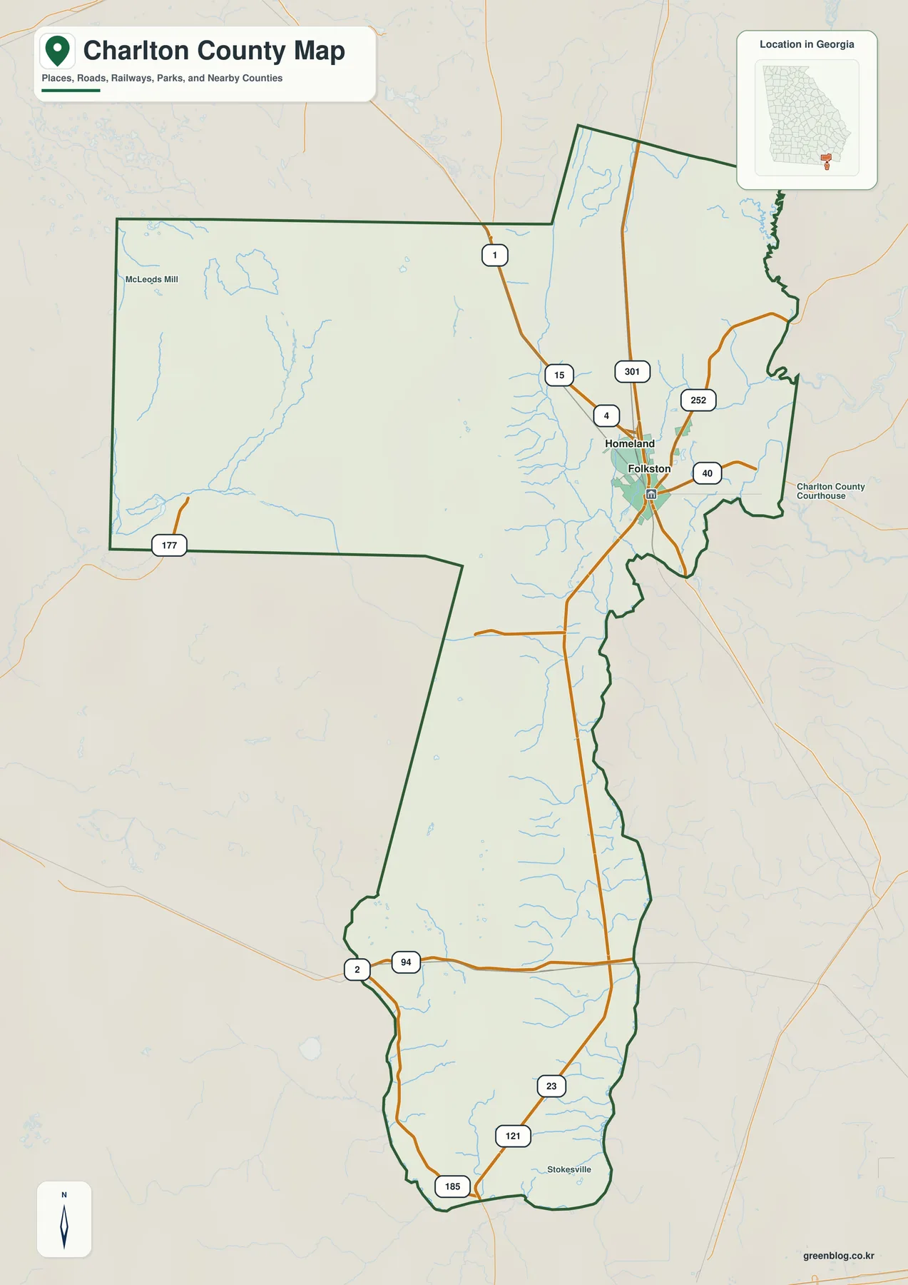
Folkston is the county seat and the clearest transportation reference point. The supplied map shows U.S. 1, 23, and 301 running through the Folkston–Homeland area, along with numbered routes such as 40, 121, 252, 177, 94, and 185 elsewhere in the county. The preserved county material explains that U.S. 1/23/301 enter Georgia across the St. Marys River and continue north through Folkston; north of Homeland, U.S. 301 separates from U.S. 1/23. That highway pattern helps explain why the two cities appear close together even though the county itself stretches a long distance to the west and south.
Other labels on the map, including McLeods Mill, Stokesville, and the Charlton County Courthouse, give useful orientation without turning the image into a detailed street map. The outer line should be read as a county-level boundary reference. It is not a parcel survey, a precise municipal-boundary layer, or the legal boundary of Okefenokee National Wildlife Refuge, and it should not be used for property or jurisdiction decisions that require current official records.
| State / FIPS | Georgia / 13049 |
|---|---|
| County seat | Folkston |
| Created | 1854 |
| 2020 population | 12,518 |
| 2025 population estimate | 13,121 |
| Land area | 780.09 square miles |
| Ranked cities on the supplied map | Folkston and Homeland |
| Major water systems | Suwannee River and St. Marys River systems |
Folkston and Homeland occupy a small eastern part of a very large county
The city-distribution map simplifies Charlton County to its two ranked incorporated places. Folkston is shown first with 4,631 residents, while Homeland is second with 755. Both markers sit close together in the eastern portion of the county. That arrangement is useful because it makes the imbalance between the compact municipal area and the much larger rural, forested, and wetland landscape immediately visible.
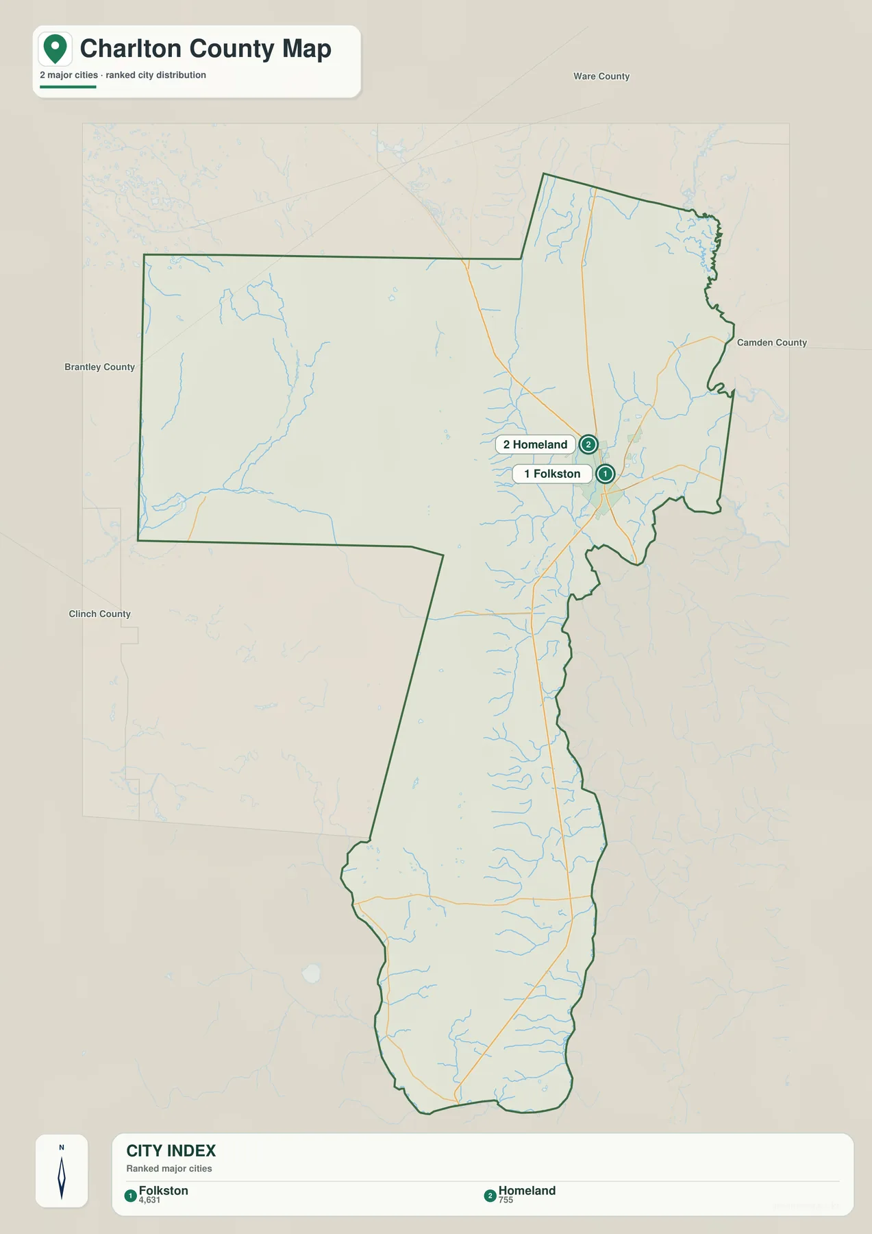
Folkston is more than the administrative center. The earlier county material notes that rail traffic converges through town in a pattern popularly known as the Folkston Funnel. Rail service reached the area in the 1880s, and the county seat moved from Traders Hill on the St. Marys River to Folkston in 1901. Seeing the city marker beside the major north–south roads makes that transportation history easier to understand: government and transportation gradually became concentrated in the same place.
Homeland lies immediately north of Folkston but remains a separate municipality. Southern communities such as St. George and Moniac are important to local geography, yet they are not ranked on this particular city map. A reader looking for every community should therefore use the city map as a broad orientation tool rather than a complete settlement inventory. Official road and administrative sources are better for unincorporated places, service areas, or address jurisdiction.
The Suwannee and St. Marys systems drain different sides of Charlton County
The water map reveals a feature that is easy to miss on a road map: Charlton County is tied to two major river systems. On the western side, the Suwannee River and Middle Fork Suwannee River are labeled near the Okefenokee region. Farther south, the St. Marys River appears along the lower part of the county near the Georgia–Florida boundary. The preserved local explanation describes water leaving the Okefenokee in different directions, with the Suwannee continuing through Florida toward the Gulf of Mexico and the St. Marys flowing toward the Atlantic.
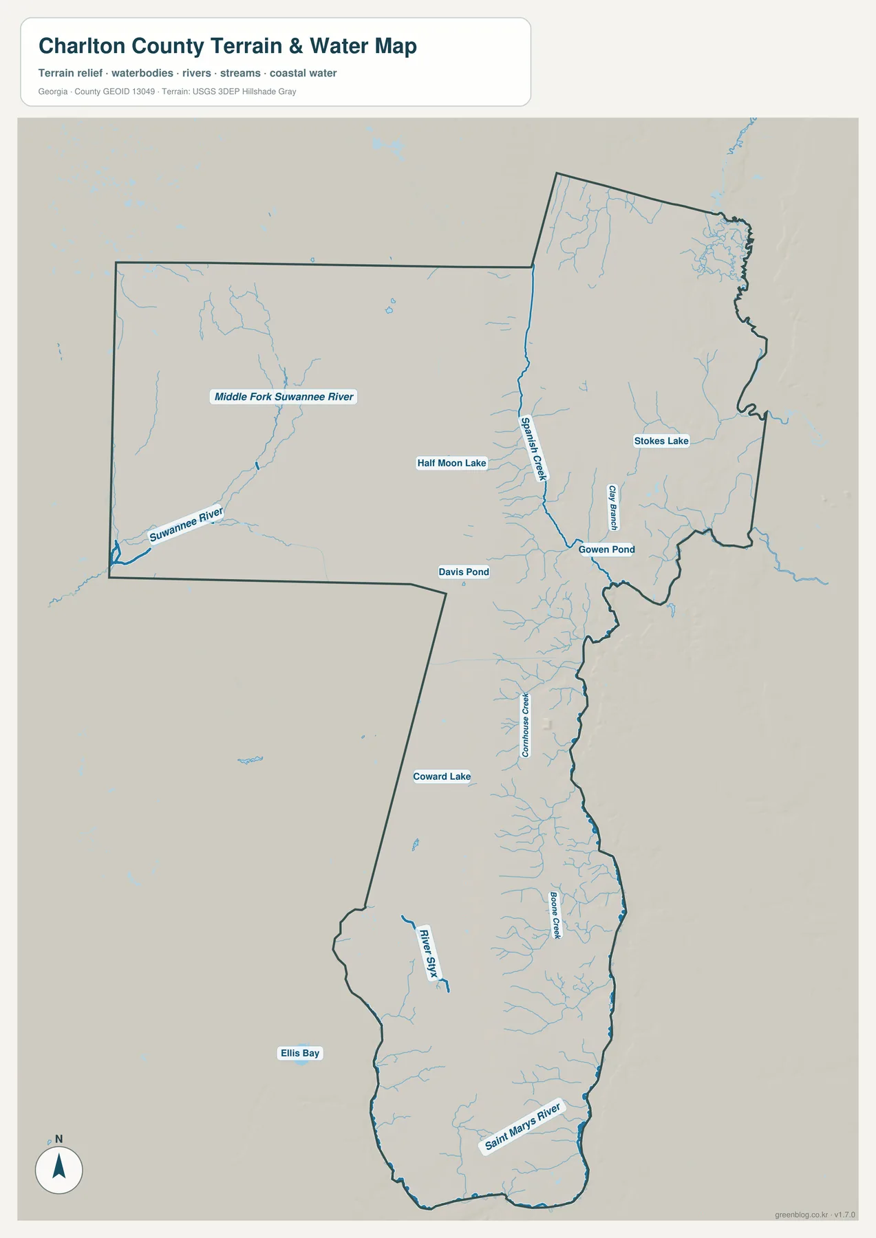
Smaller names make the drainage network more concrete. Spanish Creek runs through the eastern side of the broad northern section, while Gilly Branch, Cornhouse Creek, and Boone Creek appear farther south. The map also labels River Styx, Half Moon Lake, Stokes Lake, Coward Lake, Davis Pond, Gowan Pond, and Ellis Bay. These features show how thoroughly water is woven into the county landscape. The abundance of blue lines is especially noticeable when compared with the small number of city markers.
This is not a flood-hazard map. A stream symbol shows the location of a mapped water feature, not a regulatory floodplain or the probability that a road or property will flood. The same caution applies to travel inside the Okefenokee: current water levels, fire conditions, smoke, closures, and access rules can change. Use the map to understand the geography, then consult the U.S. Fish and Wildlife Service, USGS, and local emergency sources when a current decision depends on conditions in the field.
Elevation differences are modest across this low Coastal Plain county
Charlton County is not a mountain county, and the elevation map should be read with that in mind. The supplied graphic reports an actual elevation range of roughly 0 to 76 meters with a mean of 30 meters. Colors and shaded relief make small local differences visible, but those differences occur within an overall low landscape. The useful question is not where the highest peak is; it is where slightly higher ground and lower drainage areas sit in relation to the county’s many waterways.
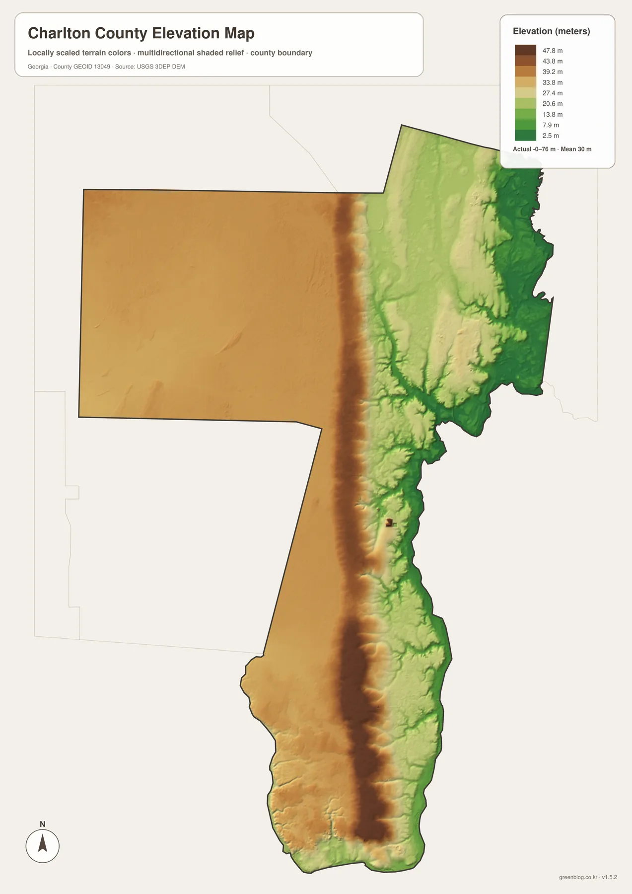
The western block and the long eastern and southern section appear in different tones, while numerous lower drainage lines cut through the colored surface. Comparing this map with the water map is more useful than reading the colors by themselves. Creeks and wet areas tend to follow the lower parts of the surface, and the many small tributaries help explain why even modest changes in elevation can influence where water collects and moves.
The elevation surface is generalized for county-wide visualization. It is not survey-grade data and should not be used to determine the exact elevation of a house, a road shoulder, a construction site, or a parcel. Engineering, drainage design, and site planning require more precise measurements. Here the elevation map is best used to compare broad terrain with the county, city, and water maps.
Road and rail routes concentrate around Folkston before spreading across wet country
Travel across Charlton County is shaped by water and wetlands. U.S. 1/23/301 provide the major north–south connection through Folkston and Homeland, while Georgia 121 continues south toward St. George and Florida according to the preserved county material. A straight line from one point to another may cross swampy ground or a river, so the practical route often depends on where highways and crossings have been built. The basic map makes this especially clear in the long southern section, where only a few major road corridors traverse a very large area.
Folkston also functions as an eastern gateway to the Okefenokee. The existing source material places the main Suwannee Canal Recreation Area entrance about 11 miles southwest of town. That is close enough for Folkston to be a useful orientation point, but the county map is not a refuge navigation map. Visitors should use current refuge directions for entrances, trails, boat routes, operating hours, and closures, especially during dry periods when wildfire and smoke can affect access.
Charlton County’s center shifted from Traders Hill to a railroad town
Charlton County was created in 1854 from part of Camden County, with additional land from Ware County added in 1855. The preserved history material says the county was named for Robert Milledge Charlton, a Georgia lawyer and former U.S. senator. Its first county seat was Traders Hill on the St. Marys River, a location that reflected the importance of river travel and trade before rail transportation changed the local pattern.
After rail service reached the area, Folkston grew into the stronger transportation center and became the county seat in 1901. That history is visible in the modern map arrangement: Folkston sits beside the main road and rail corridor, Homeland lies just to the north, and the county extends far into landscapes with very few incorporated places. The result is a county where a compact transportation center and an enormous wetland environment exist side by side.
Choosing the right Charlton County map for a specific task
Start with the county map when you need the boundary, major roads, Folkston, Homeland, and a general sense of neighboring areas. Use the city map when the main question is where the two ranked municipalities sit within the much larger county. The water map is the better choice for the Suwannee and St. Marys systems and their tributaries, while the elevation map adds the subtle terrain differences that are difficult to see on a conventional road map.
- Place Charlton County on the Georgia–Florida border for a lesson or presentation
- Compare Folkston and Homeland with the county’s much larger wetland and rural area
- Trace U.S. 1/23/301 and Georgia 121 in relation to the county boundary
- Compare the Suwannee and St. Marys drainage systems and named tributaries
- Use the elevation view to explain a low Coastal Plain landscape without implying mountain relief
Use these downloads as geographic reference maps rather than replacements for live navigation or official regulatory records. For property boundaries, emergency conditions, refuge operations, engineering elevations, or flood-hazard decisions, consult the agency that maintains the current authoritative data.
Frequently Asked Questions
Why does the city map emphasize only Folkston and Homeland?
The supplied city map ranks the two incorporated places selected for this county view: Folkston and Homeland. Other communities, including St. George and Moniac, remain important locally but are not displayed with the same ranked city symbols. Use the map to understand the main municipal pattern, then use current road or administrative sources when you need every unincorporated community.
Do the Suwannee and St. Marys rivers drain in the same direction?
No. The preserved county material describes the Suwannee leaving the Okefenokee toward Florida and the Gulf of Mexico, while the St. Marys flows toward the Atlantic and helps define the Georgia–Florida border. The water map makes the separation easy to see because the Suwannee system is labeled on the western side and the St. Marys appears along the lower part of the county.
Can the water and elevation maps be used to decide flood risk?
No. They show mapped waterways and broad terrain, not regulatory flood zones, predicted inundation, or parcel-level drainage conditions. A flood-risk decision requires current FEMA, USGS, weather, and local emergency information. The same principle applies to wildfire, smoke, refuge access, and road closures.
Map File Information
Charlton County high-resolution map files
- Included Versions: county, city, water, and elevation
Related Maps
Sources and reference material
This article is based on the four supplied maps and county-specific material preserved in the rewrite package. Population, boundaries, refuge operations, and other details that can change should be checked against the latest agency pages when accuracy matters.
- U.S. Census Bureau QuickFacts: Charlton County – population and land-area reference
- Charlton County government: History – county formation and county-seat background
- U.S. Fish and Wildlife Service: Okefenokee National Wildlife Refuge – refuge context and current visitor information
- U.S. Geological Survey: North Prong St. Marys River at Moniac – southern water-system reference
- USGS 3D Elevation Program – elevation-data reference
Green Map creates custom-edited map images using open geographic data sources such as geoBoundaries, Natural Earth, OpenStreetMap, and government open data. These maps are edited visual materials, not raw data files, and are provided for education, documents, presentations, and graphic reference.