Chatham County occupies a distinctive part of Georgia’s Atlantic coast, with Savannah at its center, Pooler and Bloomingdale to the west, the Savannah River port corridor to the north, and Tybee Island at the ocean-facing eastern edge. The county is not simply a block of land around Savannah. Rivers, tidal channels, marshes, interior islands, and barrier islands divide the landscape, so the road and city pattern makes much more sense when it is viewed together with water and elevation.
This page pairs four map views: a county reference map, a ranked city map, a terrain-and-water map, and an elevation map. After reviewing them on the page, you can download one ZIP containing four high-resolution A3 JPG files for printing, lessons, presentations, or county-to-county comparison. These maps are designed for county-scale orientation. Parcel boundaries, active road conditions, flood insurance zones, and hurricane evacuation orders require the appropriate current official source.
Table of Contents
Savannah, the County Boundary, and the Main Road Connections
Savannah is the clearest reference point on the county map. Pooler and Bloomingdale lie to the west, while Port Wentworth and Garden City sit closer to the Savannah River side of the county. East of Savannah, the map labels Thunderbolt and Wilmington Island before U.S. 80 continues toward Tybee Island. To the south, Vernonburg, Montgomery, and Skidaway Island help show how far the county extends beyond the central city. Seeing those places together prevents the common mistake of treating Chatham County as if it were only Savannah and its immediate suburbs.
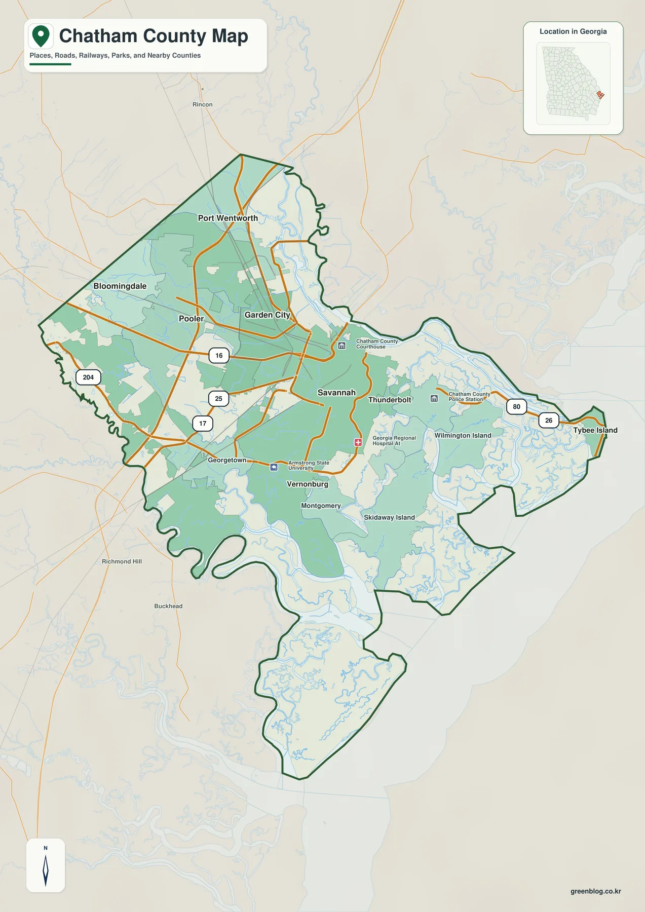
The road network separates the inland and coastal parts of the county. I-16 approaches Savannah from inland Georgia, and I-95 crosses the western side from north to south. Pooler and Bloomingdale are positioned near this western highway network. U.S. 80 works differently: it runs through the Savannah area and continues east across waterways and islands to Tybee Island. The county map also marks routes 16, 25, 17, 204, 80, and 26, which makes it easier to compare directions between the city core, the western side, and the coast.
Chatham County is on the northern part of Georgia’s Atlantic shoreline. South Carolina lies across the Savannah River to the north. Effingham and Bryan counties are on the western side, Liberty County is to the southwest, and the county opens through sounds, marshes, and islands toward the Atlantic Ocean on the east. Because so much water lies inside and along the boundary, two places that look close in a straight line may depend on a small number of bridges and causeways for road access.
| State / FIPS | Georgia / 13051 |
|---|---|
| County seat | Savannah |
| Created | February 5, 1777; one of Georgia’s original eight counties |
| 2020 population | 295,291 |
| 2024 Gazetteer area | 432.719 sq mi land / 197.255 sq mi water |
| Main corridors | I-16, I-95, U.S. 80 |
| Major waters | Savannah River, Ogeechee River, Wilmington River, Vernon River, Atlantic coast |
| Download package | Four high-resolution A3 JPG maps in one ZIP |
Using the area figures preserved in the source package, water accounts for roughly 31 percent of the county’s total area. That proportion is useful context for reading the map. The irregular shoreline is not a decorative edge around a mostly dry county; tidal rivers, marsh channels, sounds, and islands are part of the county itself. This is especially important on the route between Savannah and Tybee Island, where road access has to cross the water network rather than follow the shortest line on a locator map.
How Savannah, Pooler, Port Wentworth, and Tybee Island Are Distributed
The city map highlights six major cities and ranks them by the values printed on the map. Savannah is first at 147,898, followed by Pooler at 28,466, Port Wentworth at 12,892, Garden City at 10,426, Tybee Island at 3,123, and Bloomingdale at 3,007. The ranking is useful, but the positions tell a more important geographic story. Savannah occupies the central part of the county, Pooler and Bloomingdale are to the west, Port Wentworth and Garden City are northwest of the central city, and Tybee Island is separated from the others on the Atlantic side.
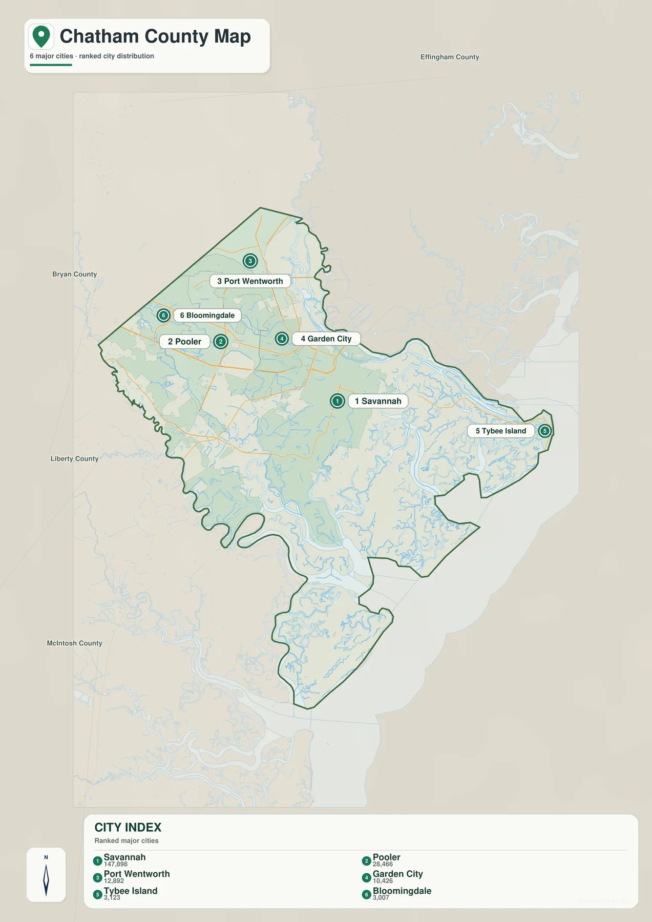
Pooler’s western position places it near I-95 and I-16, so it is easier to understand as part of the inland highway side of the county than as a coastal island community. Bloomingdale lies farther west. Port Wentworth and Garden City are closer to the Savannah River and the port corridor. The source article identifies Georgia Ports Authority facilities along this river, including Garden City Terminal northwest of central Savannah, which helps explain why those two communities appear beside a major freight and industrial area rather than beside the beach-oriented eastern edge.
Tybee Island has a very different setting even though it belongs to the same county. It lies at the eastern end of the U.S. 80 approach, after the route crosses waterways and islands east of Savannah. The ranked city map is intentionally selective, so it should not be read as a complete map of every populated community. Wilmington Island, Skidaway Island, Georgetown, and other unincorporated areas are important residential places but are not part of this six-city ranking.
Tidal Rivers, Sounds, and the Atlantic Side of Chatham County
The water map changes the emphasis completely. The Savannah River defines the northern side of the county, while the eastern half is broken by a dense network of tidal waterways. Wilmington River is labeled east of the Savannah area, and the southern side includes Ossabaw Sound and connected channels. Little Ogeechee River and Hardin Canal appear on the western side. Smaller creeks and tidal passages fill the spaces between those larger named features, showing why Chatham County has so many islands, marsh edges, and limited crossing points.
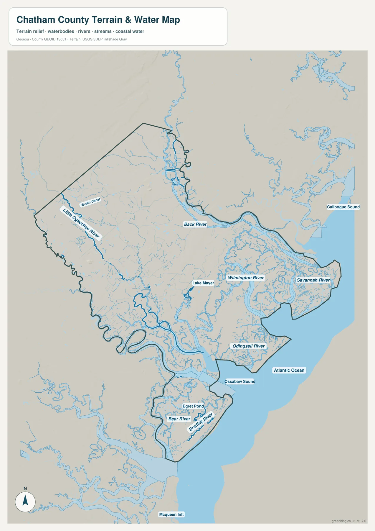
The Savannah River is more than a boundary line in the source material. It is also the shipping channel associated with the Port of Savannah, and the positions of Garden City and Port Wentworth connect directly to the road, rail, and port area along the river. East of Savannah, the Wilmington River and other tidal channels separate mainland areas from interior islands. U.S. 80 then crosses this watery landscape on the way to Tybee Island. Looking at the road map and water map together explains why east-west travel to the coast has a different pattern from movement around the western highway junctions.
The water map is not a flood-zone map. A blue river, channel, or sound does not define the regulatory floodplain around it. The source package also distinguishes Chatham County flood information, CEMA hurricane evacuation zones, and an actual evacuation order as different products with different purposes. For property research, flood insurance questions, or storm travel, use the current official layer that matches the decision instead of trying to infer it from this county-scale reference.
A Low Coastal Elevation Pattern with Limited Relief
The elevation map is striking because it shows how little relief exists across most of the county. Its legend reports an actual range of about -16 to 44 meters and a mean of 3 meters for the elevation surface used in the map. Most of the county is represented by low values, especially along the river and coastal-water network. The western inland side contains more of the lighter and brown higher areas, while broad green low areas follow the Savannah River, the eastern tidal landscape, and the southern marsh-and-sound region.
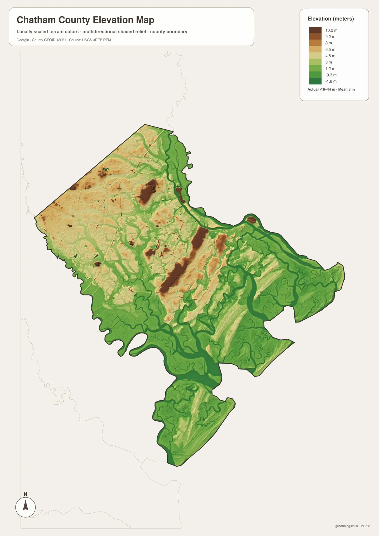
Comparing elevation with the county and water maps is more useful than reading the color scale by itself. The island and tidal areas east and south of Savannah line up with extensive low terrain, while the western side around Pooler and Bloomingdale contains a broader spread of relatively higher ground. The contrast is modest compared with a mountain county, but it helps explain why the coastline, marshes, and tidal rivers dominate the shape of Chatham County even when the county boundary is drawn as one administrative unit.
The legend values are a summary of the elevation surface used for this map, not a survey of any individual property. Do not use the image to determine a building elevation, a roadway grade, a construction datum, or a parcel’s flood status. Its best purpose is county-wide comparison: identifying where the lowest coastal and river areas are concentrated and where the inland side appears relatively higher.
One County, Several Different Settings Around Savannah
Chatham County was established in 1777 as one of Georgia’s original eight counties, according to the preserved source article. Its name honors William Pitt, the first Earl of Chatham, and Savannah, founded in 1733, remains the county seat. Those historical facts place Savannah at the long-standing center of the county, but the four maps show that the modern county cannot be described by the central city alone. The western highway communities, the Savannah River port side, and the Atlantic islands each occupy a different physical setting.
To the west, Pooler is associated in the source material with the I-95 and I-16 side of the county. To the northwest, Garden City and Port Wentworth are positioned near the Savannah River port corridor. Farther east, Wilmington Island and Tybee Island sit in the tidal and coastal part of the county. Moving from one side to the other changes not only the place names on the map but also the balance between highways, rivers, marshes, islands, and ocean access.
The source article also places Fort Pulaski National Monument on Cockspur Island along U.S. 80 between Savannah and Tybee Island. On a map, that location is useful because it sits near the Savannah River approach and the sequence of islands leading toward the Atlantic. For current visitor information, however, use the National Park Service rather than this static county map, which is meant to explain location rather than operating conditions or travel advisories.
Choosing the Best Map View for the Task
Start with the county map when you need the outer boundary, Savannah, major roads, and a broad set of place labels. Use the city map when the main question is where the six ranked cities sit in relation to one another. The water map is the clearest choice for explaining why the county breaks into mainland, river corridors, marshes, and islands. The elevation map adds the final piece by showing how low the coastal landscape is and where the western inland side becomes relatively higher.
- Compare Savannah with Pooler, Garden City, Port Wentworth, Bloomingdale, and Tybee Island.
- Trace the different roles of I-16, I-95, and U.S. 80 across the county.
- Show the Savannah River, Wilmington River, Ossabaw Sound, and other coastal waters in a lesson or presentation.
- Compare the low tidal landscape with the relatively higher western inland side.
- Build a consistent set of printable Georgia county references using the A3 JPG files.
Keep the intended scale in mind after downloading. These files are useful for orientation, comparison, and print layouts, but they do not replace live navigation, parcel GIS, flood insurance maps, port operational information, or emergency instructions. Using the correct official source for those tasks lets the reference maps remain simple and readable without asking them to carry details they were not designed to provide.
Frequently Asked Questions
Why does the city map emphasize only six cities?
The attached city map is a ranked major-city view. It highlights Savannah, Pooler, Port Wentworth, Garden City, Tybee Island, and Bloomingdale so their positions can be compared quickly. It is not intended to label every populated place or every unincorporated community in Chatham County.
What elevation range is shown for Chatham County?
The map legend reports an actual range of about -16 to 44 meters and a mean of 3 meters for the elevation surface used in the map. It is useful for comparing the low coastal and tidal areas with the relatively higher western side, but it is not a parcel or engineering elevation survey.
Can the water or elevation map be used to identify flood zones or hurricane evacuation routes?
No. The water map shows rivers and coastal waterways, and the elevation map shows county-scale height differences. Flood insurance zones, Chatham County flood information, CEMA evacuation zones, and active evacuation orders are separate products that should be checked through their current official sources.
Map File Information
Chatham County high-resolution map files
- Included Versions: county, city, water, and elevation
Related Maps
Sources and Reference Material
The administrative details, area figures, local context, and map interpretation above are based on the material preserved in the supplied package and the four attached map previews. The official pages below are useful for checking the underlying figures or obtaining current information when the task goes beyond a static county reference.
- U.S. Census Bureau: 2024 Gazetteer Files – land and water area reference
- Chatham County government: Incorporated Cities & Towns – municipal reference
- Georgia Ports Authority: Port of Savannah – Savannah River port facilities
- USGS 3D Elevation Program – elevation data reference
- National Park Service: Fort Pulaski National Monument – Cockspur Island and coastal context
- Chatham Emergency Management Agency: Evacuation Zones – current evacuation information
Green Map creates custom-edited map images using open geographic data sources such as geoBoundaries, Natural Earth, OpenStreetMap, and government open data. These maps are edited visual materials, not raw data files, and are provided for education, documents, presentations, and graphic reference.