Chattahoochee County sits directly south of Columbus on Georgia’s western edge, where the Chattahoochee River separates the county from Alabama. Cusseta is the county seat and the main civilian administrative center, but the county is unusual because a large share of its land is tied to Fort Benning. The maps on this page make that arrangement easier to understand by separating county boundaries and roads, the single ranked city center, detailed waterways, and elevation.
The on-page images are designed for quick reference. A downloadable ZIP is also provided below with four original high-resolution A3 JPG files: the county map, city map, water map, and elevation map. They can be used for classroom material, reports, presentations, or general geographic reference when a larger printable image is more useful than the web preview.
Table of Contents
Start with the county boundary and Cusseta
Chattahoochee County occupies a compact part of west-central Georgia immediately below the Columbus area. The Chattahoochee River marks its western side, with Russell County, Alabama, across the state line. Muscogee County and Columbus are to the north, while the county transitions south and east toward smaller Georgia counties. Existing county material identifies Stewart County to the south and Talbot and Marion counties on the eastern side of the surrounding area.
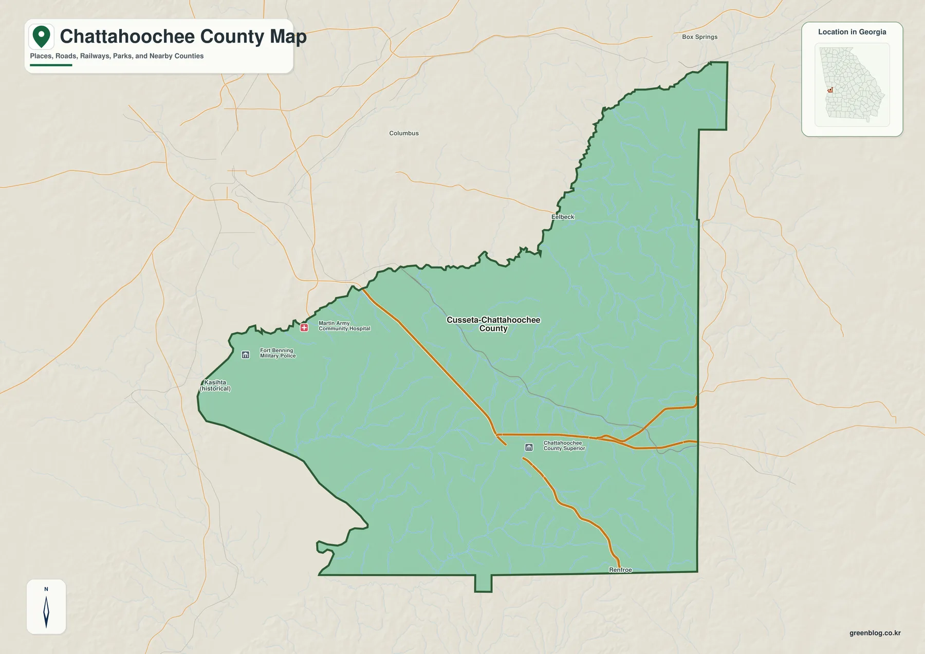
The general map is more informative than a simple outline. Cusseta–Chattahoochee County is labeled near the middle of the county, while Fort Benning Military Police and Martin Army Community Hospital appear toward the western installation area. Other labels, including a county court symbol and small local place names, help show that the county contains more than the single municipal-style label used on the city map.
Cusseta and Chattahoochee County have operated as a consolidated government since 2003. Census Gazetteer material records the Cusseta–Chattahoochee County unified-government place as coextensive with the county, so the administrative geography does not work like a typical county with several separately incorporated cities. This is one reason a reader should not interpret one prominent place name as evidence that only one settled area exists.
| County seat | Cusseta |
|---|---|
| Government | Cusseta–Chattahoochee County unified government |
| County created | February 13, 1854 |
| 2020 population | 9,565 |
| 2024 Gazetteer area | 248.737 sq mi land; 2.424 sq mi water |
| Principal roads | U.S. 27, U.S. 280/Georgia 520, Georgia 26 |
| Major natural feature | Chattahoochee River and a network of smaller creeks |
| Military installation | Fort Benning; named Fort Moore from 2023 to 2025 |
Roads through Cusseta and the connection to Columbus
U.S. 27 runs south from the Columbus area through Cusseta and continues toward Stewart County. U.S. 280 and Georgia 520 also pass through the Cusseta area on a southeastward course, and Georgia 26 connects with the same local center. These routes explain why the county seat remains the clearest civilian road junction even though the county contains extensive military land.
Columbus, just north of the county, is the nearest large urban center and an important direction for employment, medical care, shopping, and other regional services. The road network on the county map helps place Chattahoochee County within that larger Columbus relationship, but it should not be used as a Fort Benning access map. A line that appears to continue across the installation does not guarantee public access through a gate or training area.
For travel involving Fort Benning, current Army visitor and gate information is the appropriate source. Ordinary road conditions should be checked with Georgia transportation information. The downloadable county maps are intended to explain county-scale geography, not temporary closures, installation security boundaries, private parcels, or turn-by-turn navigation.
Why the city map has only one ranked center
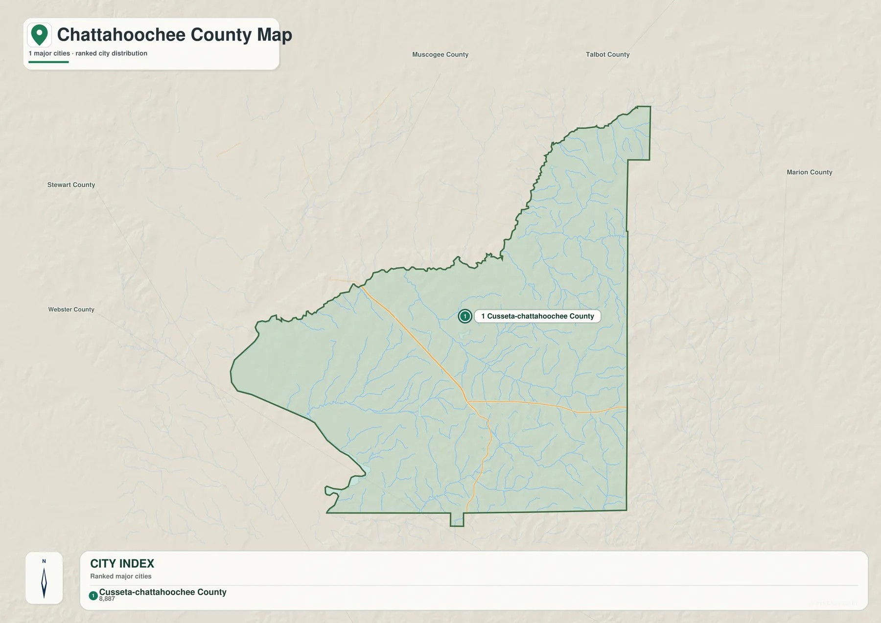
The city map contains a single ranked major-city entry: Cusseta–Chattahoochee County. Because there is no second major city in this ranking, the map does not draw the connector lines and straight-line city distances that appear on maps for counties with multiple ranked centers. The absence of those connectors is therefore part of the data structure, not a missing layer.
Names around the map, including Muscogee, Talbot, Marion, Stewart, and Webster counties, provide wider orientation. They are useful for understanding where the county sits within western Georgia, but the surrounding labels should not all be read automatically as direct border relationships. The central point is that the county’s civilian administrative focus is concentrated at Cusseta while the broader population and land-use picture includes rural areas and the military installation.
The 2026 comprehensive-plan material supplied with the package separates countywide statistics from the non-Fort Benning area. It reports a 2023 countywide population of 9,181 and a non-base population of 1,776, illustrating how strongly military assignments and base residents affect the total. That helps reconcile the city map’s single administrative center with a county population much larger than one small-town point might suggest.
The Chattahoochee River and the county’s smaller creeks
The Chattahoochee River is the defining large water feature along the county’s western edge and also provides the county name. The river continues south through the larger Apalachicola–Chattahoochee–Flint system. Inside the county, however, the water network is much finer than the main river boundary suggests. Numerous creeks drain through the interior and create small valleys across the rolling terrain.
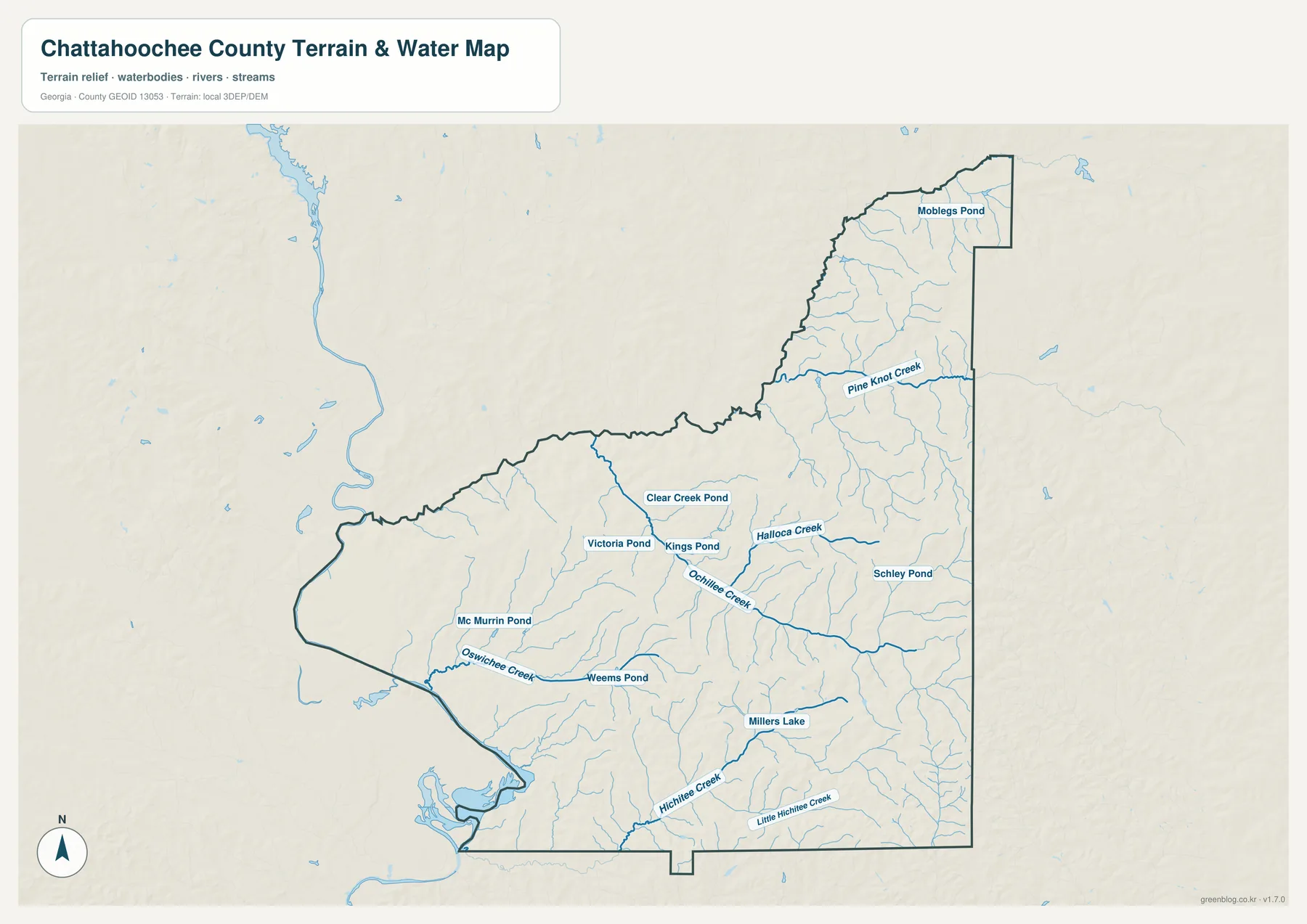
The detailed water map labels Halloca Creek, Ochillee Creek, Oswichee Creek, Hichitee Creek, Little Hichitee Creek, and Pine Knot Creek. It also identifies small water bodies such as Clear Creek Pond, Victoria Pond, Kings Pond, Schley Pond, Mc Murrin Pond, Weems Pond, Moblegs Pond, and Millers Lake. These names make the map especially useful when the question is not simply where the county is, but how water is distributed within it.
Smaller streams generally occupy the lower cuts between hills and eventually connect toward larger drainage routes. When the water map is compared with the elevation map, many of those channels can be understood as natural low corridors through the terrain. That relationship is useful for geographic study, but this is not a flood-hazard, boating, or navigation product. Current flood zones, water levels, launch access, and bridge restrictions require the responsible agency’s current information.
A clear rise from the western lowlands to the eastern uplands
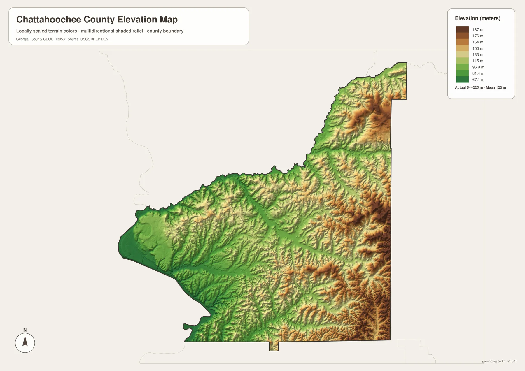
The elevation map reports an actual range of about 54 to 225 meters, with a mean elevation of about 123 meters. The western side near the Chattahoochee River appears in lower green tones, while higher orange and brown areas become more common toward the east and northeast. This difference is strong enough to make the county’s terrain understandable at a glance even without contour lines.
The eastern side is not one continuous plateau. Shaded relief reveals many narrow ridges and small valleys, and the northeastern extension contains another concentration of higher ground. In contrast, the far western edge is lower and smoother as it approaches the river. Comparing this surface with the named creeks explains why so many watercourses bend through narrow valleys before reaching lower areas.
The map is appropriate for county-scale terrain comparison, not precise engineering or survey work. The colored surface is a generalized elevation representation, so it should not be used to establish parcel elevations, construction grades, drainage design, or other measurements that require site-specific accuracy.
A county shaped by consolidated government and Fort Benning
The Georgia legislature created Chattahoochee County from parts of Muscogee and Marion counties on February 13, 1854. Cusseta was established as the county seat that year, and its name is connected with the Cussetah division of the Muscogee, or Creek, people. The later development of the military installation changed the county’s land-use pattern and population structure far more than the small size of the civilian center might suggest.
The installation was renamed Fort Moore in 2023 and designated Fort Benning again in 2025. Both names can therefore appear in recent articles, saved maps, and search results. In the supplied current material, Fort Benning is the present name, while Fort Moore refers to the 2023–2025 period.
Population trends also need that military context. The 2020 Census count was 9,565, compared with 11,267 in 2010, and the supplied planning material links part of the change to military staffing. Countywide population should therefore not be treated as a simple measure of civilian household growth or decline. The base and the non-base community contribute differently to the total.
Choose the map by the question you need to answer
For a quick view of the county outline, Cusseta, principal roads, and selected surrounding features, the general county map is the best starting point. The city map is more useful when explaining why the consolidated government produces only one ranked major-city entry. The water map is the detailed choice for creeks, ponds, and small lakes, while the elevation map provides the clearest picture of the lower river side and the higher eastern terrain.
- Use the county map for county boundaries, Cusseta, roads, and general orientation.
- Use the city map to show the single ranked Cusseta–Chattahoochee County center and the surrounding county context.
- Use the water map to locate named creeks such as Halloca, Ochillee, Oswichee, and Hichitee.
- Use the elevation map to compare the roughly 54–225 m terrain range and the west-to-east rise.
- Use the downloadable A3 JPG files when a larger image is needed for print, a slide, a lesson, or a report.
These four maps are complementary rather than interchangeable. A reader researching military access, flood risk, property boundaries, or construction elevations should move beyond this map set to the appropriate official operational or legal source. For ordinary geographic explanation, however, the combination provides a useful progression from county location to settlement pattern, water network, and terrain.
Frequently Asked Questions
Why does the city map show only Cusseta–Chattahoochee County?
Cusseta and Chattahoochee County operate as a consolidated government, and the ranked city map has only one major-city entry for the county. Other residential, military, and rural areas still exist within the county boundary; they simply are not separate incorporated-city entries in this map’s ranking.
Are Fort Moore and Fort Benning different installations?
No. They are names used for the same installation at different times. Fort Moore was the official name from 2023 to 2025, after which the installation was designated Fort Benning again. Recent documents may contain either name depending on their publication date.
Can the 54–225 meter elevation map be used for surveying or construction?
No. It is a county-scale reference surface intended to show broad terrain differences. Parcel elevations, construction grades, drainage design, and other precise work require site-specific survey or engineering data.
Map File Information
High-resolution Chattahoochee County map files
- Included Files: County map, city map, water map, and elevation map
- File Type: Four high-resolution A3 JPG files in one ZIP archive
- Intended Use: Printing, education, presentations, and map-based projects
Related Maps
Sources and reference material
- U.S. Census Bureau QuickFacts: Chattahoochee County
- U.S. Census Bureau 2024 TIGER/Line boundary and hydrography files
- New Georgia Encyclopedia: Chattahoochee County
- Georgia Department of Community Affairs: Cusseta–Chattahoochee Comprehensive Plan
- U.S. Army: Fort Benning official site
Green Map creates custom-edited map images using open geographic data sources such as geoBoundaries, Natural Earth, OpenStreetMap, and government open data. These maps are edited visual materials, not raw data files, and are provided for education, documents, presentations, and graphic reference.