Carroll County sits in western Georgia, where Carrollton forms the central reference point, I-20 ties together communities in the north, and a dense network of streams crosses rolling terrain before draining toward the Little Tallapoosa and Chattahoochee systems. This page separates those features into four maps so you can compare the county boundary, city pattern, water network, and elevation without crowding everything into one image. The WebP maps can be viewed on the page, and a single ZIP download contains four high-resolution A3 JPG files for printing, classwork, presentations, and general reference.
Table of Contents
A Western Georgia County Centered on Carrollton
Carrollton is the county seat and the easiest place to use as an orientation point. The county was created in 1825, and the existing county material lists a 2020 population of 119,148. Settlement is not concentrated in one compact belt. Bremen, Temple, and Villa Rica line up near the northern interstate corridor; Carrollton occupies the center; Bowdon lies toward the Alabama side in the southwest; Roopville is farther south; and Whitesburg sits in the southeast. Mount Zion fills part of the space between Carrollton and the northern communities.
That arrangement makes Carroll County useful for seeing how transportation, drainage, and terrain can shape a county without producing one simple urban pattern. I-20 crosses the northern tier, while US 27 and several Georgia routes lead toward Carrollton. The western side approaches the Alabama state line, and the southeastern edge becomes lower and more strongly defined by watercourses. Looking at the four maps together is more informative than relying on a single locator because each one removes some detail to make another pattern easier to see.
County Boundary, Highways, and Everyday Orientation
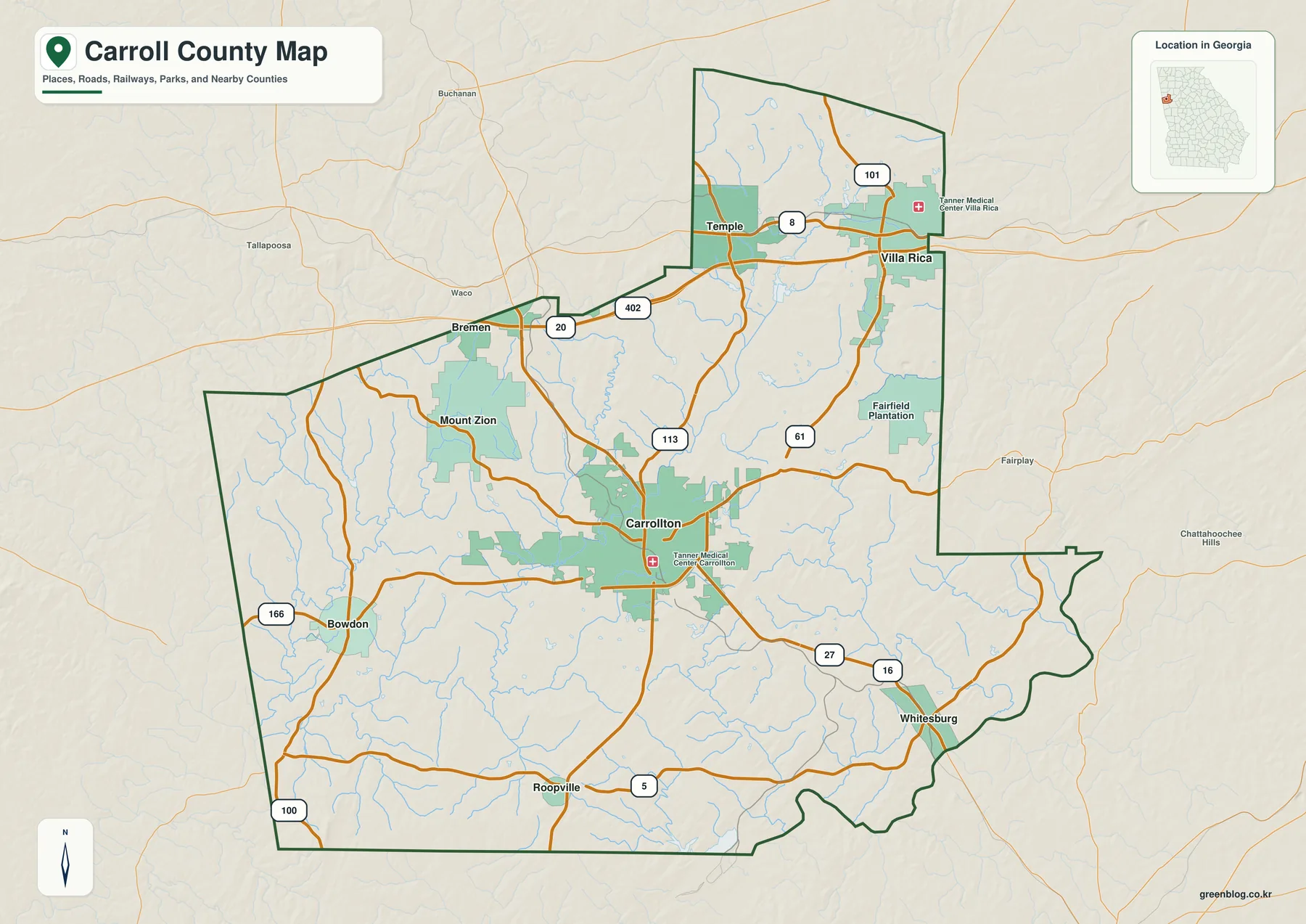
The general county map gives the broadest orientation. I-20 runs east-west across the north, where Bremen, Temple, and Villa Rica appear in sequence. Carrollton is farther south near the middle of the county, and multiple numbered roads converge around it. Labels on the map include US 27 and routes 16, 61, 113, 166, 100, and 5, along with the I-20/402 corridor. That combination makes it possible to follow the main road structure without turning the image into a detailed street map.
The county outline also shows why straight-line distance can be misleading here. Bowdon is well to the southwest of Carrollton, Roopville sits close to the southern edge, and Whitesburg is toward the irregular southeastern boundary. Villa Rica is near the northeastern side, while Mount Zion occupies the interior northwest of Carrollton. Some developed areas and medical facilities are included as visual references, but the map does not show parcels, lane-level road geometry, zoning, or exact municipal boundaries.
For travel planning, the map is best used as a first step: identify the community and the main highway connection, then check current Georgia Department of Transportation information for road conditions or construction. For property or jurisdiction questions, use an official county or city GIS instead. The purpose of this image is to make county-scale relationships readable at a glance.
Carrollton, Villa Rica, and the Major City Pattern
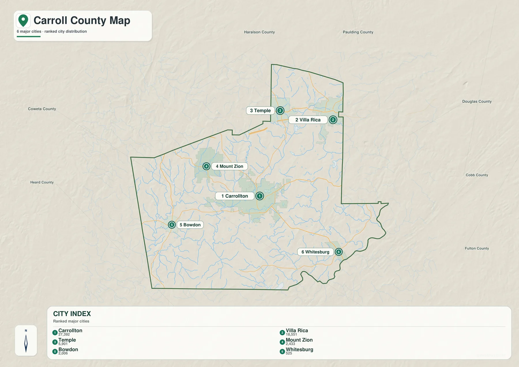
The city map strips away much of the road detail and emphasizes six communities. Its index lists Carrollton at 27,392, Villa Rica at 18,551, Temple at 5,901, Mount Zion at 2,433, Bowdon at 2,006, and Whitesburg at 525. These figures are useful here mainly as a visual ranking, not as a substitute for the county’s total population or a current demographic table.
The geography behind the ranking is just as important as the numbers. Carrollton is clearly the central city, while Villa Rica and Temple occupy the northern part of the county near the interstate corridor. Mount Zion sits west of that northern cluster, Bowdon is separated in the southwest, and Whitesburg is the southeastern outlier. The general county map adds Bremen and Roopville, so readers who need the full set of incorporated places should use both maps rather than assuming that the ranked city map is a complete municipality list.
Villa Rica and Bremen also extend beyond Carroll County into neighboring counties. A label therefore identifies the community’s presence and location; it does not mean that the entire municipal boundary lies inside Carroll County. That distinction matters for addresses, taxes, school districts, and other jurisdiction questions, all of which require more precise local data.
Little Tallapoosa River, Creeks, Lakes, and Reservoirs
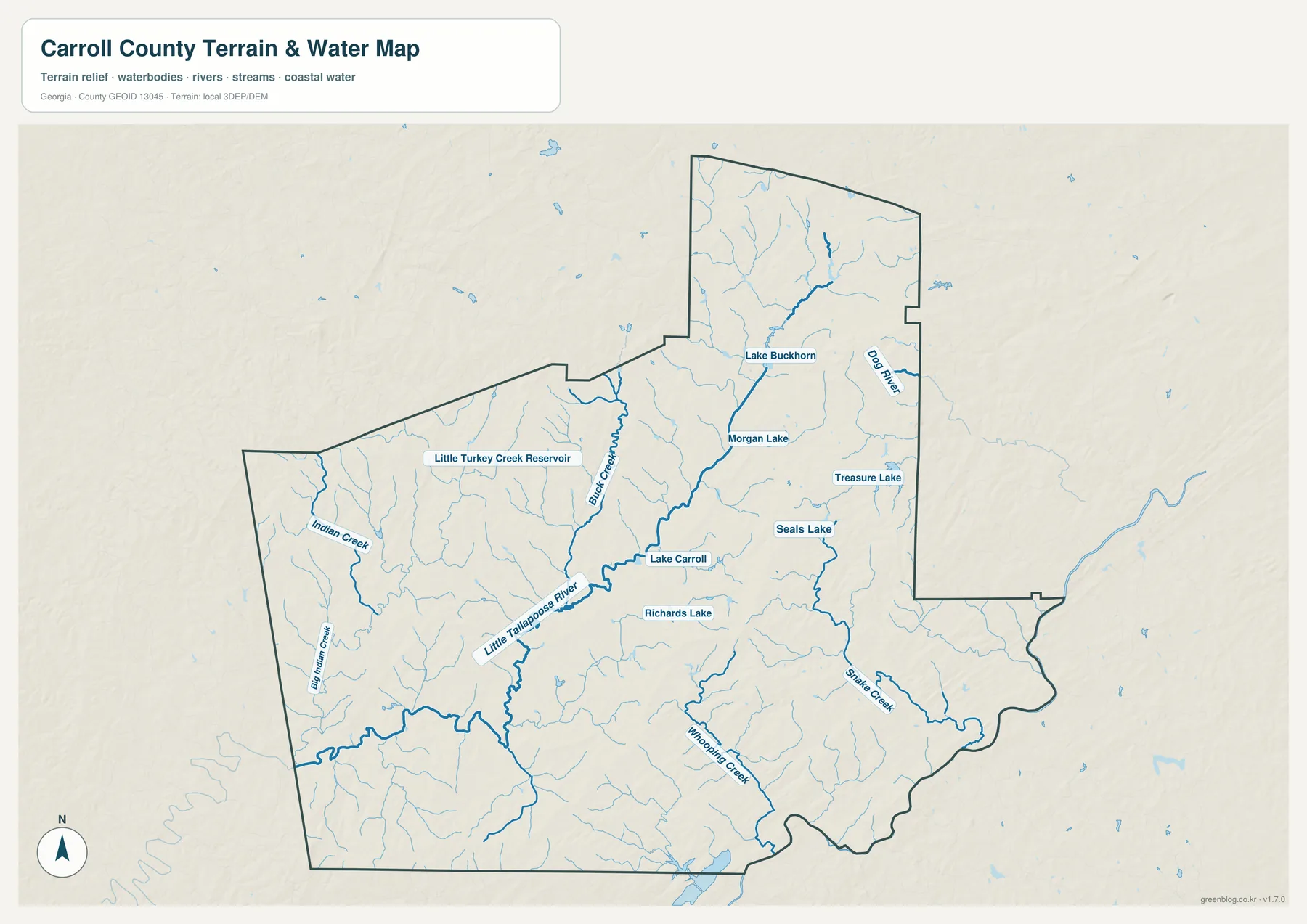
The water map makes the county look very different because the roads and city labels no longer dominate. The Little Tallapoosa River becomes the main feature across the middle of the map, collecting tributaries from several directions before continuing toward Alabama. Buck Creek joins the network from the north-central area, while Indian Creek and Big Indian Creek appear farther west. The northeastern side includes Dog River, and the southeast is crossed by Snake Creek and Whooping Creek.
Several named water bodies add useful landmarks. Little Turkey Creek Reservoir is shown in the northwest. Lake Carroll and Richards Lake sit near the central part of the county, while Lake Buckhorn, Morgan Lake, Treasure Lake, and Seals Lake are farther north and east. On the general map, many of these streams are thin background lines; on the water map, the principal channels are emphasized so their connections are much easier to follow.
The county’s existing planning material describes a divide between drainage toward the Little Tallapoosa system and drainage toward the Chattahoochee River on the southeastern side. That broad division helps explain why the southeast has a different stream orientation from the central and western parts of the county. The USGS maintains a Little Tallapoosa River gauge at Carrollton, which is a better source for actual stream observations than this static map.
This is not a flood-risk map. It does not show regulatory flood zones, expected water depth, storm forecasts, or evacuation information. If the question involves insurance, a building site, or personal safety, use FEMA mapping and current county emergency information rather than inferring risk from the presence of a stream alone.
Rolling Uplands and a Lower Southeastern Edge
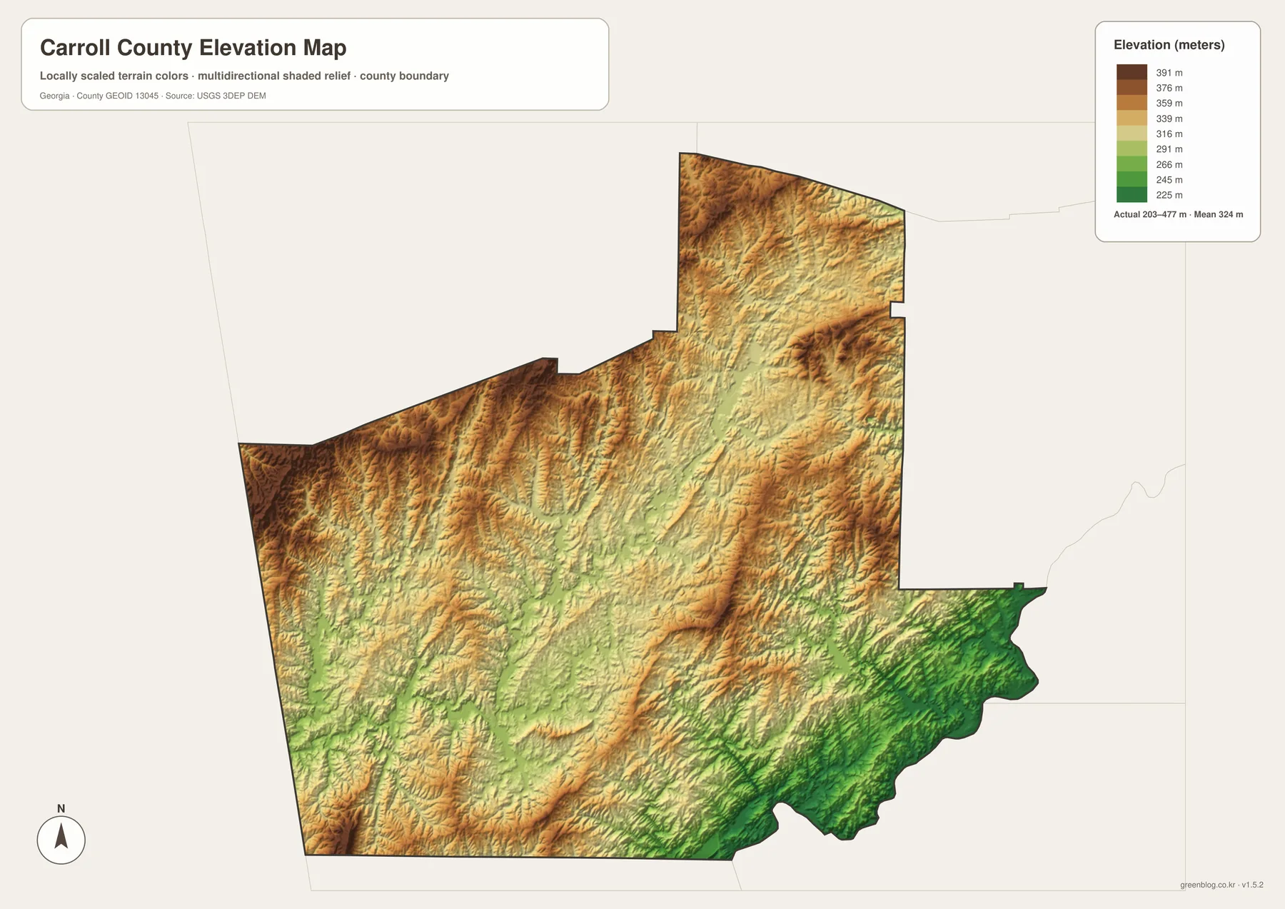
The elevation map removes place names almost entirely and lets the landform stand on its own. The printed map statistics give an actual elevation range of about 203 to 477 meters, with a mean of 324 meters. Browns and tan tones dominate many northern and western ridges, while greener colors become more common toward the southeastern edge. The surface is not a broad flat plain; short ridges and branching valleys repeat across much of the county.
Those valleys make more sense when the elevation and water maps are compared. Major streams and many smaller tributaries occupy lower corridors between ridges, while higher ground separates drainage paths. The southeastern side stands out because lower terrain becomes more continuous near the irregular boundary. The shaded relief also helps explain why two places that look close on a simple outline map may be connected by curving roads rather than straight routes.
Elevation is useful for general geographic understanding, but this image is not a slope, engineering, or construction map. It should not be used to determine whether a parcel is buildable, whether a road grade is safe, or whether a location will flood. Those questions need detailed site data and the appropriate local or federal sources.
Choosing the Right Carroll County Map
Start with the county map when the main question is location: Where is Carrollton? Which communities lie near I-20? Which road leads toward Bowdon or Whitesburg? Use the city map when you want a cleaner comparison of the larger communities. Switch to the water map for the Little Tallapoosa River, named creeks, lakes, and reservoirs, and use the elevation map when ridges, valleys, and the change from higher western terrain to the lower southeast are the main subject.
- Classroom work on Georgia counties, county seats, and major communities
- Presentation graphics showing Carrollton and the northern I-20 corridor
- Basic watershed orientation before opening detailed USGS or flood resources
- Comparing higher ridges with lower stream valleys and the southeastern edge
- Printing a clean A3 reference map without relying on a browser screenshot
Because the download contains four separate JPGs, you do not need to print every layer together. A road-and-place assignment can use the county map, a river lesson can use the water map, and a terrain discussion can use the elevation map. Keeping the themes separate also leaves more room for labels and reduces the clutter that would appear if every feature were placed on one sheet.
Frequently Asked Questions
Why does the city map highlight only six communities?
The city map is a ranked view of six major communities: Carrollton, Villa Rica, Temple, Mount Zion, Bowdon, and Whitesburg. The general county map also shows places such as Bremen and Roopville, so use the two maps together when you need a broader municipality reference.
What elevation range is shown for Carroll County?
The elevation map reports an actual range of approximately 203 to 477 meters and a mean elevation of 324 meters. Higher rolling terrain is more common in the north and west, while lower terrain becomes more prominent toward the southeast.
Can the water map be used to determine flood risk?
No. It is a geographic reference showing rivers, creeks, lakes, and reservoirs, not a regulatory floodplain product. Flood, insurance, evacuation, and building decisions require current FEMA and local government information.
Map File Information
Download the Carroll County Map Files
- Included Files: 4 high-resolution JPG map files shown in this article
- File Type: JPG files in a ZIP archive
- Intended Use: Printing, education, presentations, and map-based projects
Related Maps
Sources and Reference Data
Population and county statistics can be checked with U.S. Census Bureau QuickFacts. Historical and local context is available from the New Georgia Encyclopedia Carroll County profile. Transportation context is documented in the Carroll County transportation plan, while stream observations are available from the USGS Little Tallapoosa River gauge at Carrollton. Elevation mapping is based on the USGS 3D Elevation Program.
Green Map creates custom-edited map images using open geographic data sources such as geoBoundaries, Natural Earth, OpenStreetMap, and government open data. These maps are edited visual materials, not raw data files, and are provided for education, documents, presentations, and graphic reference.