You can download the Pike County map files on this page as a ZIP containing four high-resolution A3 JPGs. The maps cover the county as a whole, the main town connections, rivers and lakes, and elevation. Together they show how McComb and Magnolia sit along the I-55 and US 51 north-south route, how Summit and Osyka extend that line toward the county edges, and how the Tangipahoa and Bogue Chitto drainage systems cut through rolling terrain. The sections below focus on what is actually visible in the supplied maps rather than treating Pike County as a generic county outline.
Table of Contents
McComb, Magnolia, and the shape of Pike County
Pike County lies in southern Mississippi with Louisiana immediately beyond its southern boundary. The county map makes four communities especially useful as orientation points. Summit is in the north, McComb forms the largest mapped urban area, Magnolia lies a short distance farther south, and Osyka sits close to the Louisiana line. That sequence makes the county easier to understand because the principal towns are not scattered evenly across the map. They are concentrated along a narrow north-south band in the western half of the county.
I-55 and US 51 run through that same band and pass Summit, McComb, Magnolia, and the approach to Osyka. US 98 crosses the county through McComb, giving the map a strong east-west reference that links the urban corridor with the more rural eastern part of Pike County. MS 24 appears to the west, while MS 44, MS 48, MS 570, MS 575, and other state routes help fill in the local network. A rail line also runs through the McComb-Magnolia area. Seeing the roads and railway together explains why the western side has the clearest chain of labeled communities.
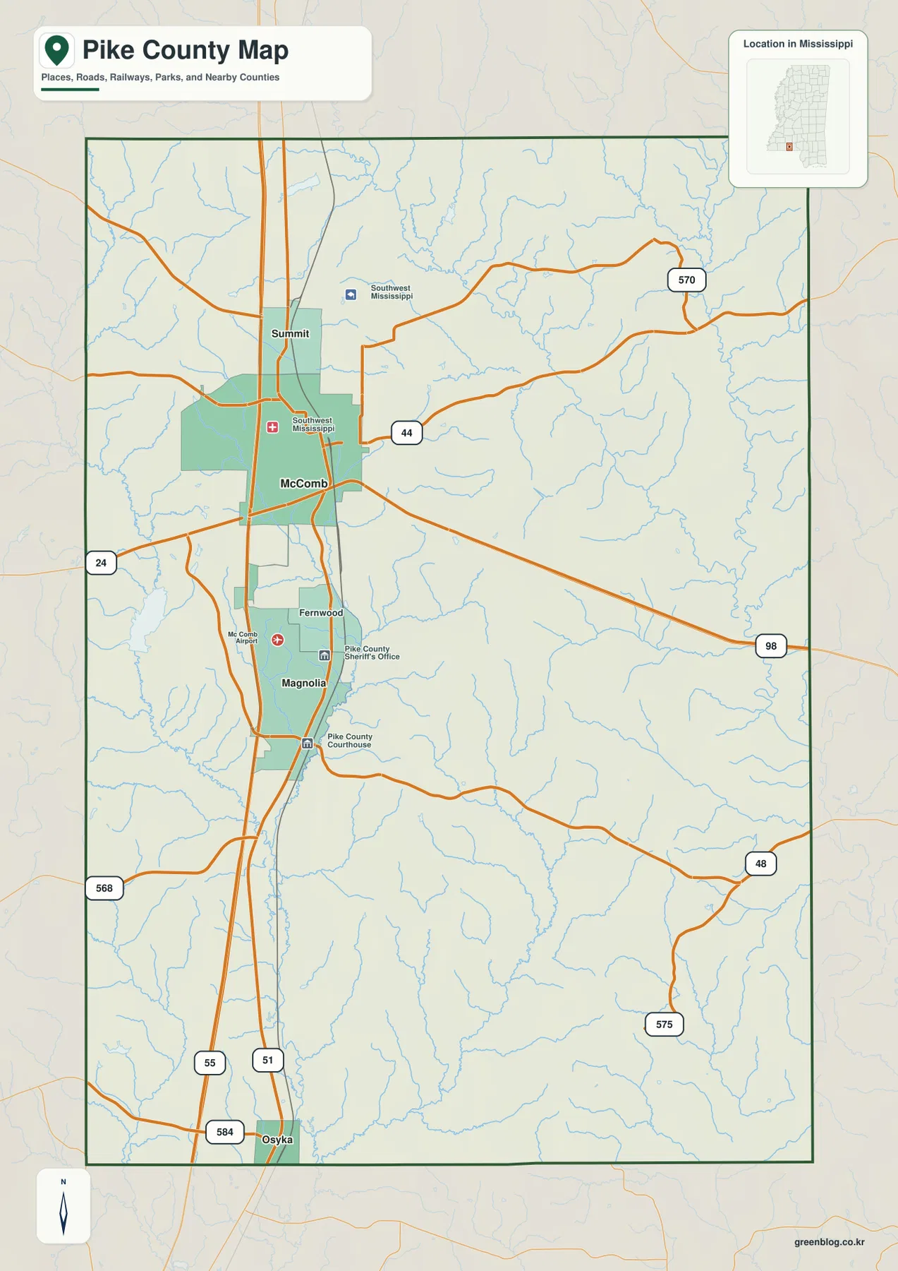
Neighboring counties provide another useful frame. Lincoln County is north of Pike County, Amite County is on the west, and Walthall County is on the east. From McComb, US 98 heads toward Amite County in one direction and Walthall County in the other. The southern edge is different because it is a state boundary rather than another Mississippi county line. Osyka is therefore an especially helpful label when explaining where Pike County ends and Louisiana begins.
Town connections along I-55 and US 51
The city map uses McComb as the hub and gives direct distances to three other mapped communities. Summit is about 4 miles from McComb, Magnolia about 5 miles, and Osyka about 15 miles. Those figures are straight-line distances between mapped city points, not driving distances, but they make the spacing of the towns immediately clear. Summit and Magnolia are close neighbors of McComb, while Osyka marks a much longer step toward the southern boundary.
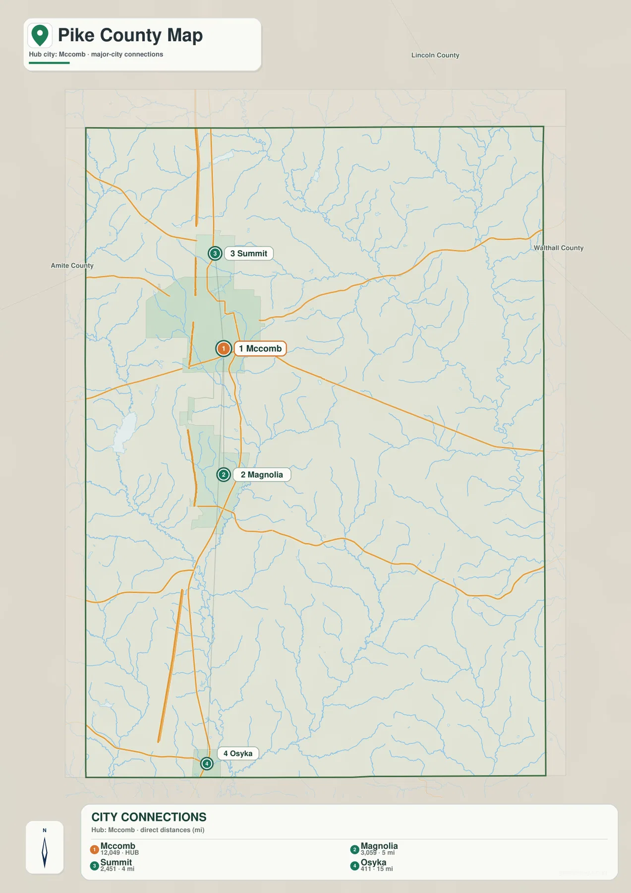
McComb and Magnolia can be easy to confuse when looking quickly at a county map because they are only a few miles apart and both sit on the main north-south route. Their roles are different. Magnolia is the county seat, while McComb occupies the larger mapped urban footprint and sits at the intersection of several important transportation lines. For a visitor trying to understand the county rather than memorize every road, the simplest sequence is Summit, McComb, Magnolia, and Osyka from north to south.
The eastern half of Pike County does not have the same concentration of large place labels. US 98 is therefore a useful bridge between the urbanized western corridor and the network of streams and smaller roads farther east. The standard county map is better when road numbers and boundaries matter, while the city map is deliberately simpler. Using both prevents a common mistake: assuming that the areas with fewer city labels are empty rather than mostly rural parts of the county.
Tangipahoa, Bogue Chitto, and the county’s water network
Water is spread across Pike County as a dense network of rivers and creeks rather than one dominant lake. The Tangipahoa River and Little Tangipahoa River are prominent in the western and central parts of the map and continue southward. Across the north, the Bogue Chitto River forms another strong reference. The eastern side includes Dog River and Topisaw Creek, while Bala Chitto Creek and several smaller named streams appear farther south. These labels show that Pike County is divided among several drainage paths instead of one simple channel running through the middle.
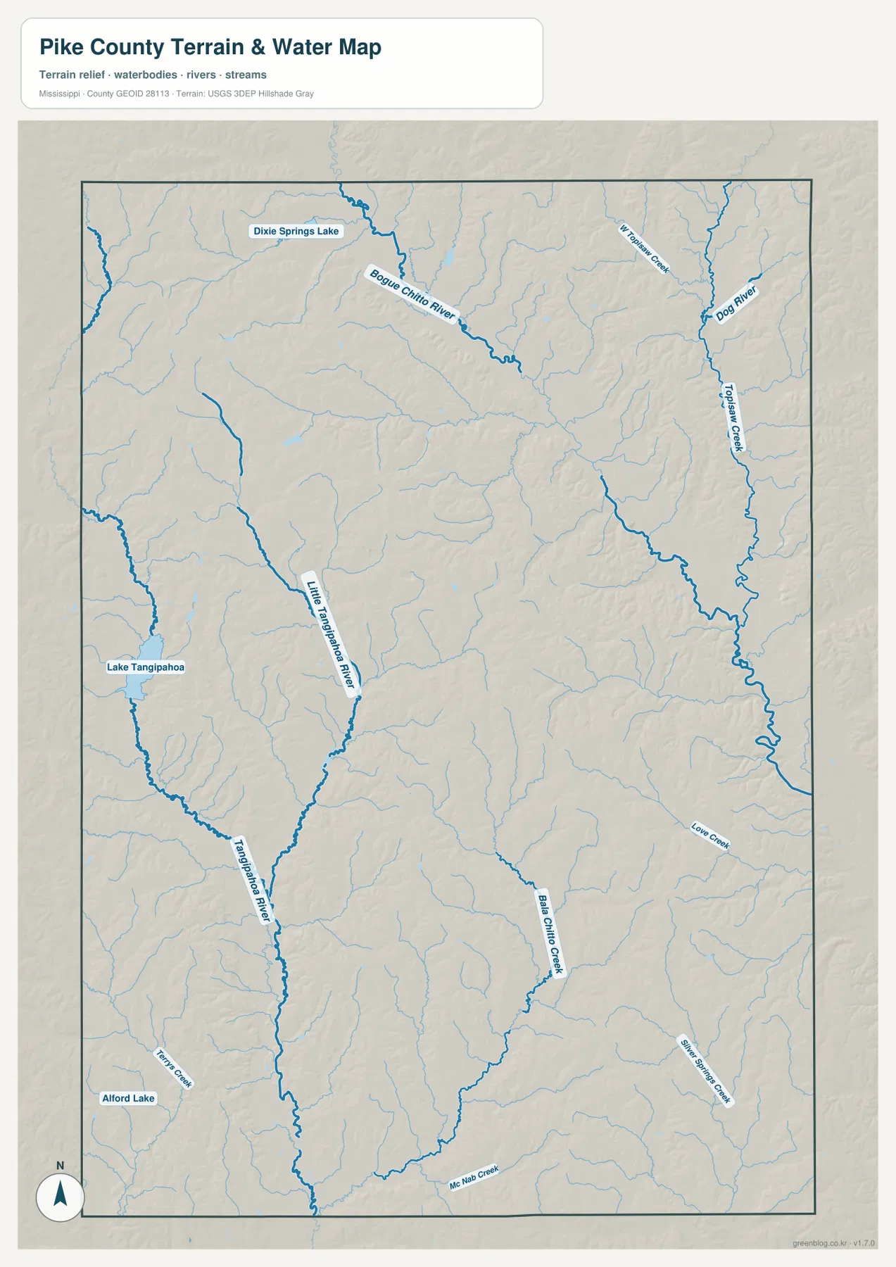
Several small lakes help with local orientation. Dixie Springs Lake is labeled in the northwest, Lake Tangipahoa in the western part of the county, and Alford Lake near the southwest. They are much smaller than the river network, so the map is best read by following the long blue river lines first and using the lakes as secondary landmarks. This is also why Pike County can look water-rich on a map even though the 2025 Gazetteer lists only 1.509 square miles of water compared with 409.185 square miles of land.
The water map becomes more useful when it is compared with the elevation map. Many green, lower areas on the elevation image follow the same general corridors as the rivers and creeks. Higher ridges rise between those valleys. The relationship is especially clear in the northern and eastern parts of the county, where branching streams cut through rolling terrain. The map is not a flood-risk product, but it does explain why waterways and elevation should be considered together when learning the county’s physical geography.
Elevation from stream valleys to rolling ridges
The elevation map reports an actual range of about 66 to 147 meters, with a mean near 109 meters. Pike County is not mountainous, yet the shaded relief makes clear that it is not uniformly flat. Brown and tan areas mark higher rolling ground, while green bands trace lower valleys. Those bands branch across the county and often align with the drainage network shown on the water map.
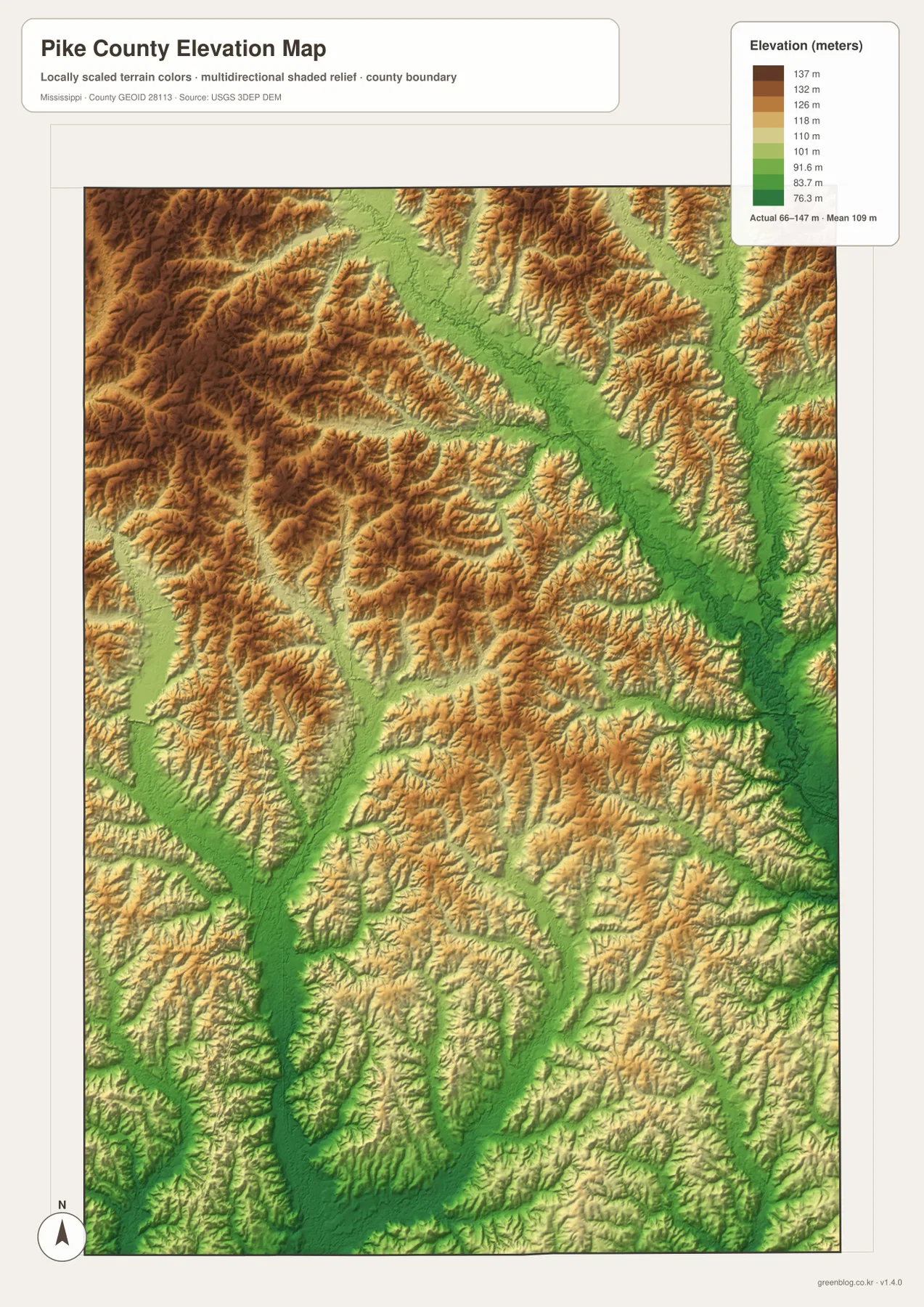
The northern part of the map contains several pronounced ridges divided by broad lower corridors. Similar but smaller ridge-and-valley patterns continue toward the south. This helps put the highway map in context. I-55 and US 51 look like nearly straight north-south lines on the county map, but the surrounding landscape is a repeating mix of low drainage corridors and higher ground. The elevation image is intended for county-scale comparison, not for surveying a parcel or reading an exact elevation at a house or road intersection.
Facts that help put the maps in context
- State and county: Mississippi, Pike County
- FIPS code: 28113
- County seat: Magnolia
- Primary labeled communities: McComb, Magnolia, Summit, Osyka
- 2020 Census population: 40,324
- July 2025 population estimate: 38,712
- 2025 Gazetteer area: 409.185 sq mi land and 1.509 sq mi water
- Density using the 2020 population and listed land area: about 98.5 residents per sq mi
- Mapped elevation range: about 66–147 m, mean about 109 m
The population figures use different reference dates. The 2020 Census count of 40,324 and the July 2025 estimate of 38,712 describe the county as a whole, not any one city. The density figure is likewise a county-level average derived from the listed land area. It should not be read as if McComb, the smaller towns, wooded hills, farms, and stream valleys all contain the same number of residents per square mile.
The land and water figures also explain an apparent contrast in the maps. Water covers only a small share of the county’s total area, but thin rivers and creeks can cross a great deal of land without adding much surface area. A drainage map can therefore contain many blue lines while the county still has relatively little open water. This is one reason the four map types complement one another rather than repeating the same information.
Choosing the map that fits the task
Use the county map when you need the broadest view of towns, roads, railways, county boundaries, and streams on one page. The city map is faster for explaining how McComb, Magnolia, Summit, and Osyka line up along the north-south corridor. The water map is the better choice for identifying the Tangipahoa and Bogue Chitto systems, selected lakes, and eastern creeks. The elevation map adds the missing vertical dimension by showing how those waterways occupy lower ground between rolling ridges.
For a classroom presentation, the county map can establish location before the water or elevation map explains the landscape. For a simple regional comparison, the city map shows which communities are close to McComb without clutter from every local road. The maps can also be useful as visual references in reports or design work, especially when a larger source image is needed. They are not substitutes for live navigation, property surveys, engineering plans, or official flood-hazard determinations.
Frequently Asked Questions
Is McComb the county seat of Pike County?
No. Magnolia is the county seat. McComb appears larger on the map and is the main hub used in the city-connection graphic, but the administrative seat is Magnolia. The two communities are only about 5 miles apart in the direct-distance map, which can make their roles easy to mix up.
Which rivers are most useful for reading the Pike County water map?
The Tangipahoa River and Little Tangipahoa River are strong references in the western and central parts of the county. In the north and east, the Bogue Chitto River, Dog River, and Topisaw Creek help organize the drainage network. Smaller creeks and lakes add local detail around those larger features.
How much elevation change does the Pike County map show?
The supplied elevation map lists an actual range of roughly 66 to 147 meters and a mean near 109 meters. The county has rolling relief rather than mountains: lower stream valleys separate higher ridges and hills throughout much of the map.
Sources and reference data
- U.S. Census Bureau QuickFacts for Pike County – census and population estimate context
- U.S. Census Bureau Gazetteer Files – land and water area reference
- Mississippi Department of Transportation official highway map – principal highway reference
- USGS National Hydrography – river and stream data reference
- USGS 3D Elevation Program – elevation data reference
- Mississippi Department of Archives and History map records – regional map and historical reference
Map File Information
The ZIP contains the Pike County county map, city map, water map, and elevation map as high-resolution A3 JPG files. Use these originals when you need a larger file than the WebP previews shown on the page.
- Included Files: 4 high-resolution A3 JPG map files shown in this article
- File Type: JPG files in a ZIP archive
- Intended Use: Printing, education, presentations, and map-based projects
Related Maps
Green Map creates custom-edited map images using open geographic data sources such as geoBoundaries, Natural Earth, OpenStreetMap, and government open data. These maps are edited visual materials, not raw data files, and are provided for education, documents, presentations, and graphic reference.