Burke County stretches across a broad part of eastern Georgia, with Waynesboro near the center and the Savannah River forming the county’s eastern edge toward South Carolina. The maps on this page are designed to do more than show an outline: one emphasizes roads and places, another isolates the city pattern, a third traces creeks, ponds, and river corridors, and the elevation map shows where the land rises and falls. After reviewing the previews, you can download one ZIP containing four high-resolution A3 JPG maps for printing or offline reference.
Waynesboro is the easiest place to begin. Keysville sits to the northwest, Vidette to the west, Midville to the southwest, Sardis to the southeast, and Girard to the east. Once those place labels are combined with Brier Creek, the Ogeechee River edge, and an elevation range of roughly 22 to 143 meters, the county’s geography becomes much easier to understand than it would from a boundary outline alone.
Table of Contents
Waynesboro, the road network, and the county outline
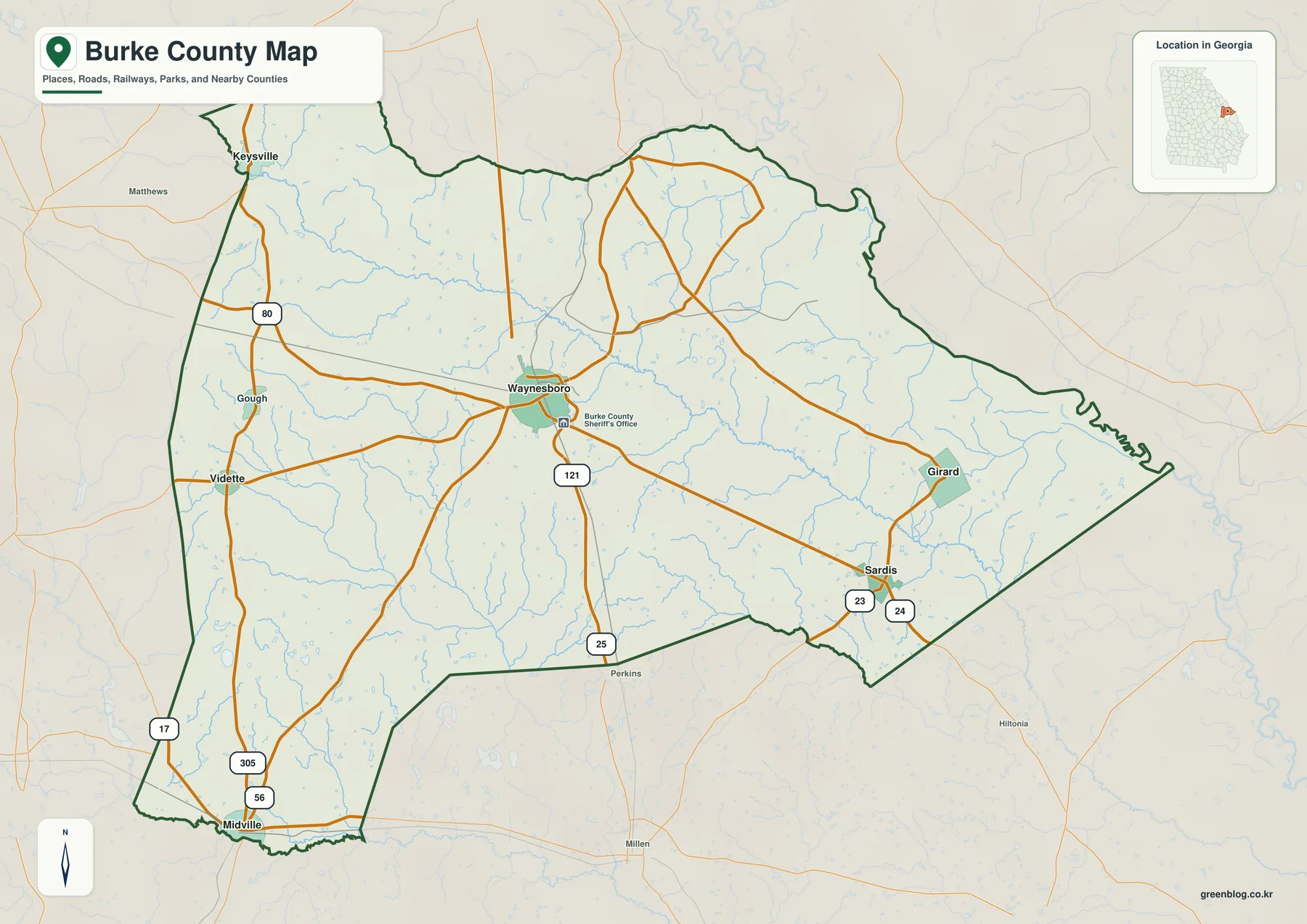
The general county map brings the boundary, selected communities, roads, and streams into one view. Waynesboro occupies the central part of the county and several numbered routes spread away from it toward the outer towns. The map labels routes 25, 80, 121, 24, 23, 17, 305, and 56, making it useful for understanding how the western, southern, and eastern parts of Burke County relate to the county seat before opening a turn-by-turn road map.
Keysville lies close to the northwestern edge, while Vidette and Midville occupy the western and southwestern sides. Sardis is southeast of Waynesboro and Girard is farther east. The separation among these places matters because Burke County covers a large rural area; the outer communities are not simply suburbs arranged around a compact urban center. The map instead shows a central hub with long road connections reaching through farmland, wooded areas, and creek valleys.
The eastern side is tied to the Savannah River and the South Carolina border in the county material supplied with this package. Elsewhere the county line bends around a mixture of road corridors and drainage features rather than following a simple rectangular form. This map is appropriate for regional orientation, but it should not be used to determine parcels, municipal limits, property access, or a legal boundary at a specific address.
How the six labeled communities are distributed
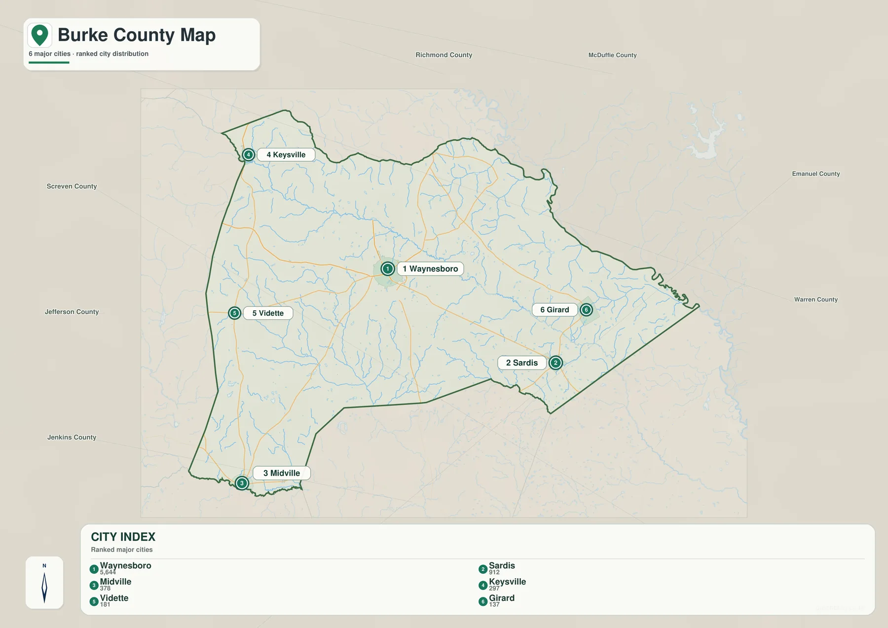
The city map strips away much of the road detail so the placement of the six selected communities is easier to compare. Waynesboro is ranked first in the map’s city index, followed by Sardis, Midville, Keysville, Vidette, and Girard. That ranking belongs to this prepared map and should not be read as a complete list of every incorporated or named place in the county. Its main value is showing how widely the selected towns are spaced.
From Waynesboro, Keysville is northwest and near the upper-left county edge. Vidette is west, Midville sits much farther southwest, Sardis is southeast, and Girard is east. The pattern helps explain why a traveler may need to cross a substantial portion of the county to move from one outer town to another. It also shows why Waynesboro works well as a reference point even when the trip itself does not end there.
Burke County’s municipal information includes places beyond the six labels used in this artwork, including Blythe as a city located wholly or partly within the county. The omission of a place name from this map therefore does not mean that it falls outside Burke County. The graphic is a selected city-distribution view, not a legal municipal-boundary map or a complete gazetteer.
Names of nearby counties appear around the city map to provide broader orientation. Those labels are useful for recognizing the part of Georgia in which Burke County sits, but an exact jurisdictional question should still be checked against current Census boundary data or local government records. The city map is best treated as a simple geographic overview rather than a substitute for official boundary files.
Brier Creek, the Ogeechee River edge, and smaller waterways
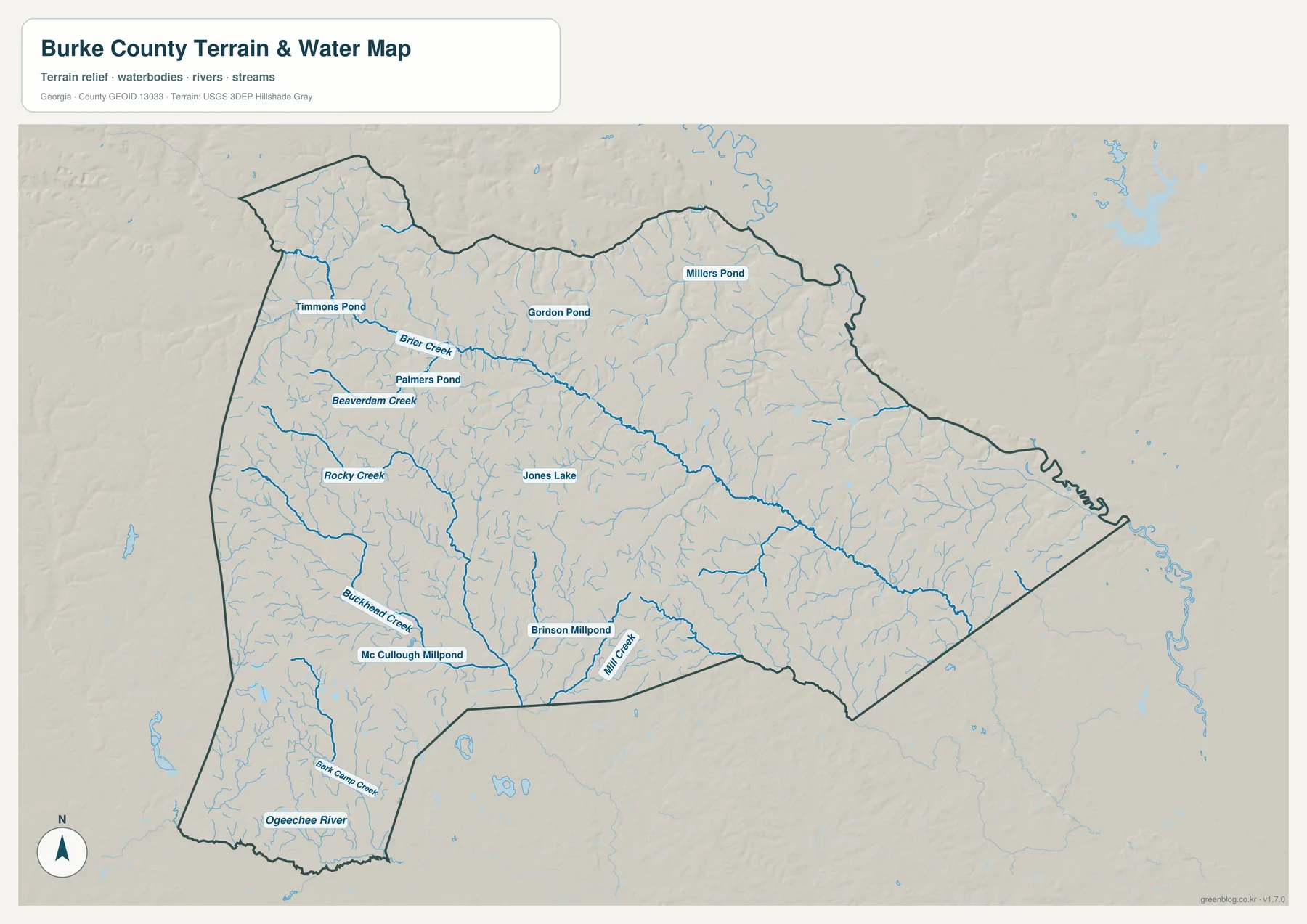
Brier Creek is the most prominent named waterway on the terrain-and-water map. It enters from the northwest and runs diagonally across a large part of the county before continuing toward the eastern side. Numerous small tributaries join it along the way, so the map reveals a much denser drainage network than the road-focused county view. That difference is important in a rural county where many local landscapes are organized around creeks, low valleys, and small impoundments.
The western half includes Beaverdam Creek and Rocky Creek, with Buckhead Creek and Bark Camp Creek farther south. The Ogeechee River is labeled at the southwestern edge. Mill Creek appears in the south-central part of the county, where Brinson Millpond is also shown. Together these features show that Burke County is not defined by one major river alone; smaller branches and creek systems reach through nearly every part of the county.
Several named ponds and small lakes add another layer of detail. Timmons Pond and Palmers Pond are near the northwestern Brier Creek area, while Gordon Pond and Millers Pond appear farther north and northeast. Jones Lake, Mc Cullough Millpond, and Brinson Millpond are scattered through the interior and southern portion. These names are especially useful for readers comparing rural locations that may be far from the six city labels.
This is a reference map of water locations and terrain, not a flood-hazard, navigation, wetland-jurisdiction, or property-boundary product. A creek shown on the map should not be used by itself to decide whether a parcel is in a flood zone or whether a particular crossing is open. Flood planning, water regulation, and access questions require current information from the responsible federal, state, or local agency.
Elevation from about 22 to 143 meters
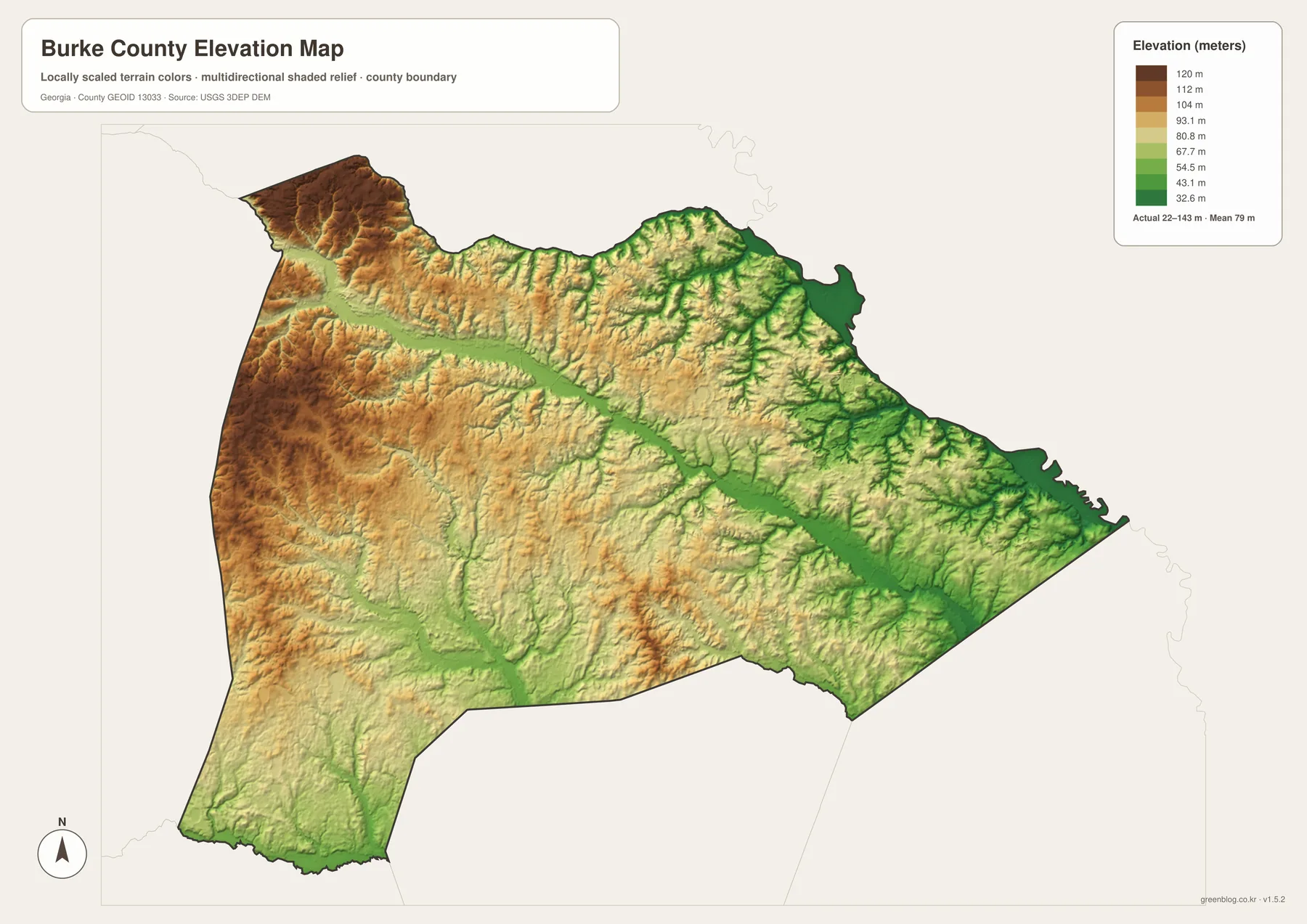
The elevation map records an actual county range of about 22 to 143 meters, with a mean near 79 meters. The western and northwestern portions contain many of the higher brown and tan areas, while lower green terrain becomes more common along major creek valleys and toward the eastern side. The contrast is not mountainous, but it is strong enough to show that Burke County has a varied surface rather than a uniformly flat plain.
One of the clearest features is the long lower corridor associated with Brier Creek. When the elevation map is compared with the water map, the green band follows the same general path as the creek and its tributaries. Small ridges and higher patches rise on either side. This makes the two maps particularly useful as a pair: one names the waterways while the other shows the relief that shapes their valleys.
The eastern river side also contains broad lower areas and many narrow drainage cuts. In the west, higher terrain surrounds the Vidette and Keysville sides, although low stream valleys still break up the uplands. The southwestern corner has its own lower corridors around the Ogeechee River and connected creeks, so the terrain is better described as a patchwork of uplands and drainage valleys than as a simple west-to-east slope.
The shaded surface is generalized for county-scale comparison. It is not survey-grade elevation and should not be used for building design, grading, drainage engineering, or a precise site-height determination. For work that depends on exact measurements, consult the underlying USGS 3D Elevation Program data or a professional survey.
Choosing the map that fits the question
For a first look at Burke County, the general map is the quickest way to place Waynesboro, the outer communities, and the main road numbers in one frame. The city map is better when the goal is to compare the six selected settlements without extra road detail. Readers interested in natural features can then switch to the water map to trace Brier Creek and the smaller branches that cross the rural interior.
The elevation map becomes most useful after the water network is familiar. Lower green corridors line up with several of the named streams, while higher western areas stand out more clearly when the creek valleys are already known. Reading the two together helps explain why a route that looks nearly straight on a simple county map may pass through a sequence of low crossings and rolling higher ground.
For trip planning, use the county and city maps only as an orientation step. Straight-line spacing between two labels is not driving distance, and actual travel depends on the road network, bridges, closures, and the route selected. For classroom work, regional presentations, or personal reference, the four maps can instead be used side by side to show how settlement, transportation, water, and elevation describe the same county in different ways.
Plant Vogtle is identified in the supplied Burke County reference material as an important facility on the Savannah River side of the county. These four maps are not facility maps and do not show plant property, security areas, evacuation routes, or emergency-planning zones. Georgia Power and the appropriate emergency agencies should be used for current operational or safety information.
Frequently Asked Questions
Where are the six labeled communities relative to Waynesboro?
Keysville is northwest of Waynesboro, Vidette is west, and Midville is southwest. Sardis lies to the southeast and Girard to the east. The map is useful for direction and relative position, but actual driving mileage depends on the road and bridge network.
What are the main waterways shown on the Burke County map?
Brier Creek is the longest and most visually prominent named creek, running from the northwest across much of the county. The Ogeechee River is labeled along the southwestern edge, and the map also includes Rocky Creek, Beaverdam Creek, Buckhead Creek, Mill Creek, Bark Camp Creek, and several named ponds and millponds.
Can the elevation map be used for surveying or engineering?
No. The map summarizes county-scale relief, with an actual range of about 22 to 143 meters and a mean near 79 meters. Precise construction, drainage, grading, or property work should rely on the underlying USGS elevation data and professional survey information.
Map File Information
A3 JPG map files
- Included Files: county, city, water, and elevation maps shown in this article
- File Type: High-resolution A3 JPG files
- Intended Use: Printing, education, presentations, and map-based projects
Related Maps
Sources and reference data
- U.S. Census Bureau TIGER/Line: county boundaries and geographic reference data
- USGS National Hydrography: rivers, creeks, and water features
- USGS 3D Elevation Program: elevation source data
- New Georgia Encyclopedia: Burke County history and regional background
- Burke County government: municipalities in Burke County
- Georgia Power: Plant Vogtle location and unit information
Green Map creates custom-edited map images using open geographic data sources such as geoBoundaries, Natural Earth, OpenStreetMap, and government open data. These maps are edited visual materials, not raw data files, and are provided for education, documents, presentations, and graphic reference.