Hancock County is a coastal Mississippi county where the road map, waterways, and elevation map tell noticeably different parts of the same story. Bay St. Louis and Waveland sit near Mississippi Sound, Diamondhead is farther inland along I-10, and Pearlington marks the western side near Louisiana. The maps on this page make it possible to compare those places with the county’s major roads, rivers, creeks, coastal water, and changing elevation. High-resolution A3 JPG versions are also available together in a ZIP download for printing or reuse.
The county is not uniformly flat even though much of the south lies close to sea level. Broad low ground dominates the coast and lower river corridors, while the northern part rises into a more textured landscape of ridges and shallow valleys. Jourdan River and a network of creeks cross that transition before reaching St. Louis Bay and Mississippi Sound. Looking at the four supplied maps together is especially useful here because the settlement pattern is concentrated in the southeast while the county itself extends much farther north and west.
Table of Contents
Roads connect the southeastern coast with a much larger inland county
The county map places Bay St. Louis and Waveland close together along the southeastern shoreline. US 90 serves that coastal area, while I-10 runs farther north through the county and past Diamondhead. MS 43 heads north from the I-10 area toward Kiln, and MS 603 continues through the interior. MS 53 appears in the northeastern part of the map, while MS 607 reaches toward Pearlington and the southwestern side. These routes make the shape of the county easier to understand because the populated coast occupies only one corner of a much broader land area.
Hancock County’s outline becomes irregular near the coast and western wetlands. Pearlington provides a useful reference near the Louisiana side, while the eastern edge opens toward St. Louis Bay and Mississippi Sound. North of the coast, the county widens considerably and contains long stretches with fewer city labels. The map is useful for seeing the relationship among county boundaries, principal roads, and named communities, but it is not intended to replace parcel maps, evacuation maps, or detailed street navigation.
Bay St. Louis, Diamondhead, and Waveland form a compact southeastern cluster
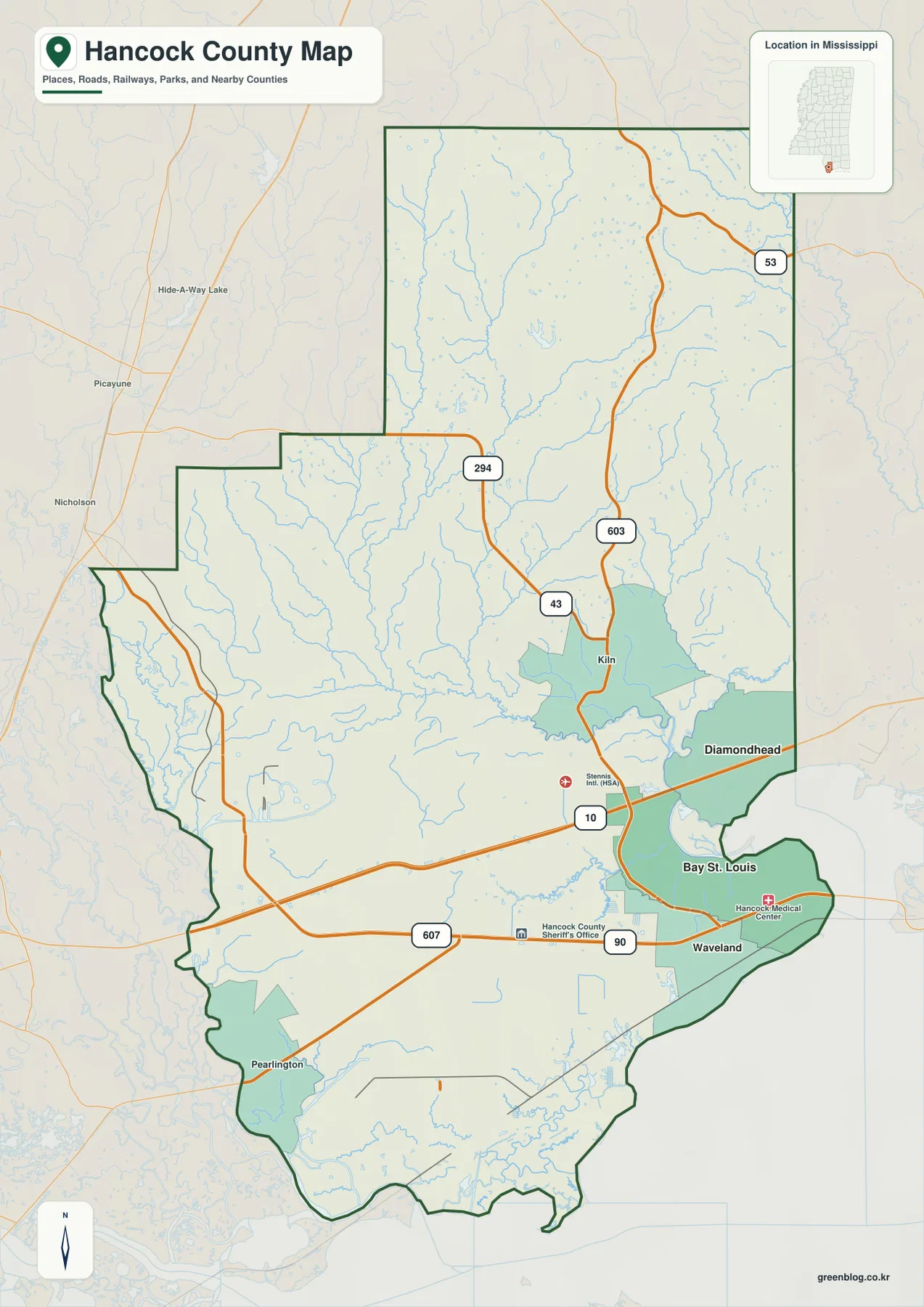
The city-connections map emphasizes three places: Bay St. Louis, Diamondhead, and Waveland. Its CITY CONNECTIONS panel lists values of 10,188 for Bay St. Louis, 9,338 for Diamondhead, and 7,062 for Waveland. Because the map does not print a reference year beside those figures, they are best treated as the supplied city-index values rather than as current population claims. What matters most visually is how tightly the three places occupy the southeastern part of the county.
Bay St. Louis is used as the hub. The map gives a straight-line distance of about 4 miles to Diamondhead and about 2 miles to Waveland. These are not driving distances; actual road travel follows the street network and may be longer. Waveland lies immediately south of Bay St. Louis, whereas Diamondhead is northeast and closer to the I-10 corridor. That contrast makes the city map useful for explaining the difference between the coastal settlement cluster and the inland community tied to the interstate.
Jourdan River and interior creeks lead toward St. Louis Bay and Mississippi Sound
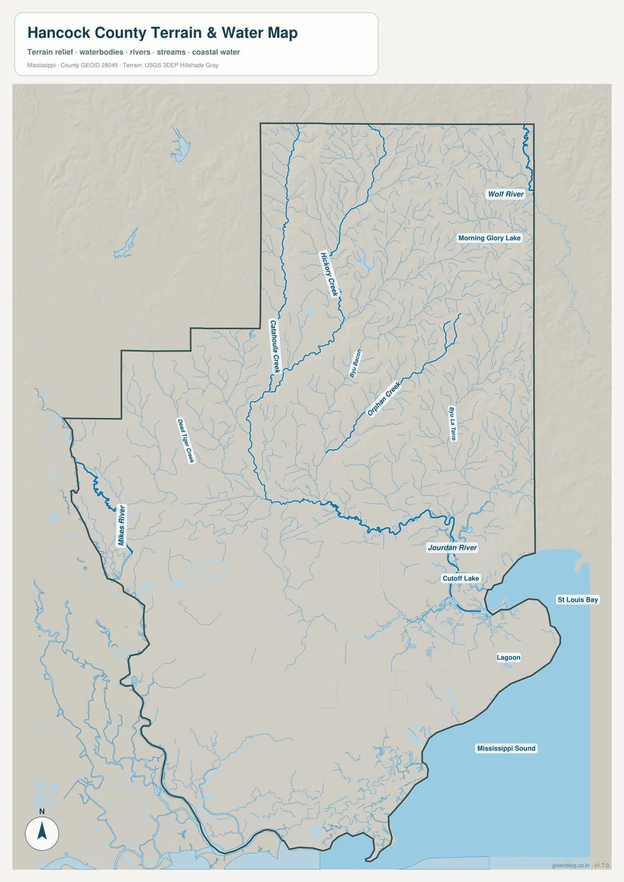
Water is one of the strongest visual features of Hancock County. Jourdan River crosses the central and southeastern part of the county before reaching the coastal bay system. Farther north, Wolf River is labeled near the northeastern side. Hickory Creek and Catahoula Creek descend through the north-central interior, while Orman Creek and Bayou La Terre occupy the eastern drainage area. Morning Glory Lake and Cutoff Lake are also labeled, adding smaller water bodies to a map otherwise dominated by rivers, creeks, and coastal water.
The southern and southwestern parts contain many smaller channels and marshy waterways, even where individual names are not printed. St. Louis Bay stands out on the southeast, and Mississippi Sound fills the broader coastal edge beyond it. Together with the rivers and wet lowlands, these features help explain why the county’s water area is substantial. This map should be used as a geographic reference for water locations, not as a flood-risk map, navigation chart, wetland jurisdiction map, or legal property-boundary source.
Elevation rises from near sea level in the south to northern ridges
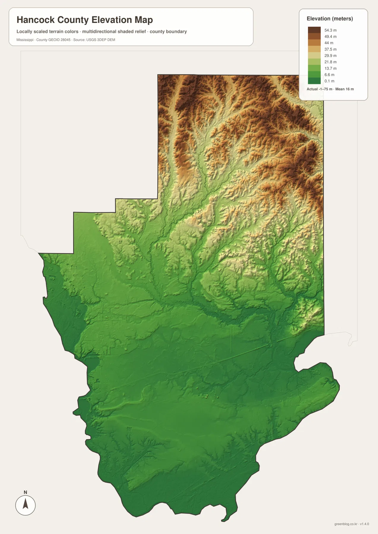
The elevation map reports an actual range of about -1 to 75 meters and a mean elevation of 16 meters. Most of the southern half is shaded green, indicating broad low terrain around the coast, wetlands, lower river corridors, and the Pearlington side of the county. The lowest areas are not confined to a narrow beach strip; low ground extends well inland along waterways and across the southern plain.
The terrain changes substantially in the north. Ridges become more frequent in the north-central and northeastern sections, where tan and brown shading replaces the broad greens of the coast. Creeks occupy lower cuts between those ridges and generally descend toward the lower southern and eastern parts of the county. The elevation surface is appropriate for county-scale comparison, but it is not survey-grade data for construction, drainage engineering, or determining the elevation of a specific lot.
Population and area figures add scale to the map
- County seat: Bay St. Louis
- FIPS code: 28045
- 2020 census population: 46,053
- July 2025 population estimate: 46,873
- 2025 Gazetteer land area: 473.966 square miles
- 2025 Gazetteer water area: 78.799 square miles
- Density using the 2020 count and 2025 land area: about 97.2 residents per square mile
The census count and the July 2025 estimate refer to different dates, so they should not be treated as measurements from the same moment. The nearly 79 square miles of water are easier to appreciate after looking at St. Louis Bay, Mississippi Sound, the rivers, and the wet southern margin on the water map. The city map also shows why a countywide density number can be misleading if read too literally: the principal urban places are concentrated in the southeast rather than evenly distributed across the entire county.
Choose the map that matches the question you need to answer
For roads and general orientation, the county map is the most useful starting point because it combines Bay St. Louis, Waveland, Diamondhead, Kiln, Pearlington, and the major routes. The city map is better when the goal is to compare the southeastern population centers and their straight-line spacing. For water features, the terrain-and-water map makes Jourdan River, Wolf River, St. Louis Bay, Mississippi Sound, and the creek network much easier to follow. The elevation map is the clearest choice for comparing the low coastal plain with the higher terrain in the north.
The WebP images in the article are page-friendly previews. If you need files for printing, classroom use, a report, or a larger layout, use the high-resolution JPG archive below. The ZIP contains the same four map subjects shown in the article, so you can select only the file that fits your purpose rather than placing every map into one document.
Frequently Asked Questions
How far are Diamondhead and Waveland from Bay St. Louis on the city map?
The supplied city map shows straight-line distances of about 4 miles from Bay St. Louis to Diamondhead and about 2 miles to Waveland. Those values compare city positions and should not be used as driving distances.
Which water features stand out most in Hancock County?
Mississippi Sound and St. Louis Bay dominate the southeastern coast, while Jourdan River is the most prominent labeled river crossing the interior toward the bay. Wolf River and several named creeks add important inland references.
Where is the higher terrain in Hancock County?
The elevation map shows the broad southern half as low terrain, while the north-central and northeastern sections contain more ridges and higher ground. The mapped range is approximately -1 to 75 meters, with a mean of 16 meters.
Map File Information
The Hancock County county, city, water, and elevation maps are packaged as high-resolution A3 JPG files. Use the ZIP below when you need a printable or editable copy rather than the WebP previews shown in the article.
- Included Files: County map, city map, water map, elevation map
- File Type: JPG
Related Maps
Sources and References
- U.S. Census Bureau Hancock County QuickFacts
- U.S. Census Bureau Gazetteer Files
- Mississippi Department of Transportation official highway map
- NASA Stennis Space Center
- USGS National Hydrography
- USGS 3D Elevation Program
Green Map creates custom-edited map images using open geographic data sources such as geoBoundaries, Natural Earth, OpenStreetMap, and government open data. These maps are edited visual materials, not raw data files, and are provided for education, documents, presentations, and graphic reference.