This Berrien County Georgia Map page lets you download one ZIP containing four high-resolution A3 JPG maps after previewing the county, city, water, and elevation views online. Berrien County lies in inland south Georgia, with Nashville as the county seat and Alapaha, Enigma, and Ray City positioned to the north, northwest, and south. The WEBP previews are convenient for quick reading, while the JPG files are intended for printing, classroom material, documents, presentations, and other map-based reference work.
A useful way to get oriented is to start at Nashville, then look north to Alapaha, northwest to Enigma, and south to Ray City. U.S. 82 explains much of the northern east–west pattern, U.S. 129 provides the clearest north–south route through the named communities, and the Alapaha River adds a natural feature that does not follow the road network. The elevation view then shows why the northern part of the county has more visible relief than the lower southern and river-side areas.
Table of Contents
County roads, boundaries, and the Nashville hub
The general county map is the best place to begin because it keeps the major place names, numbered highways, county outline, streams, and nearby context together. Nashville appears in the central-southern portion of Berrien, where several routes meet. U.S. 129 runs north toward Alapaha and south toward Ray City. Across the northern part of the county, U.S. 82 connects the Enigma side with Alapaha, making the two federal highways a simple framework for understanding the locations of all four labeled communities.
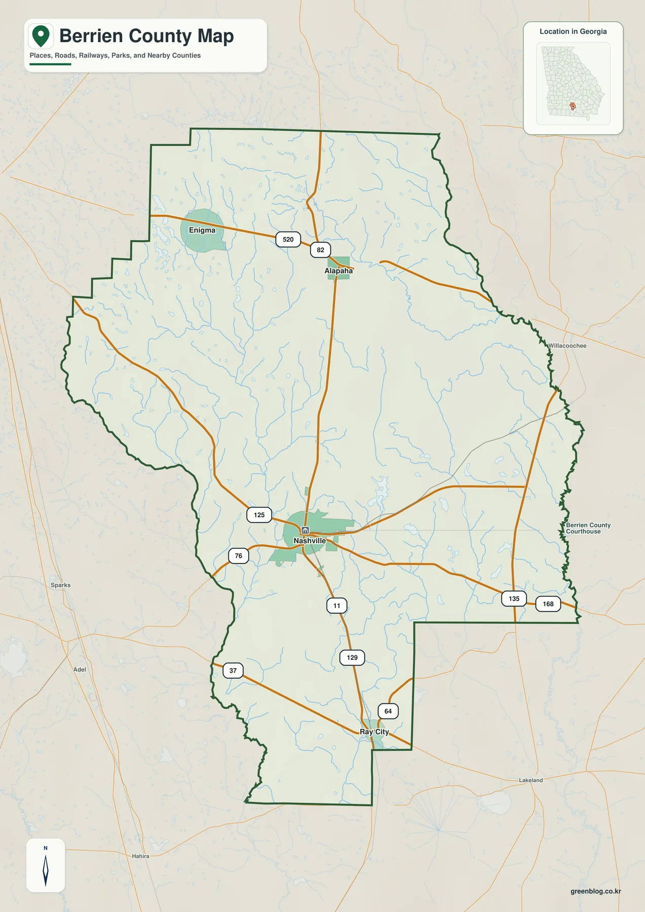
Additional route numbers visible on the map include 520, 125, 76, 11, 37, 64, 135, and 168. They show how Nashville connects outward in several directions rather than depending on a single corridor. Alapaha is the northern junction where the U.S. 82 and U.S. 129 patterns come together, Enigma sits to the west along the U.S. 82 side, and Ray City occupies the southern end of the labeled settlement pattern. This is a county-scale orientation map, so it should not be treated as a street map, parcel map, or source for exact municipal limits.
| State | Georgia |
|---|---|
| County | Berrien County |
| County seat | Nashville |
| Created | 1856 |
| 2020 population | 18,160 |
| 2020 land area | 453.38 square miles |
| FIPS code | 13019 |
| Labeled communities | Nashville, Alapaha, Enigma, Ray City |
| Major water feature | Alapaha River and connected streams and ponds |
| Download | ZIP with four high-resolution A3 JPG files |
The 2020 Census counted 18,160 residents, and Census geography lists 453.38 square miles of land. Those figures help explain the large rural spaces visible between the town labels. A sparse label pattern does not mean the land between Nashville and the smaller communities is empty; the county includes farms, forested tracts, ponds, wetlands, small roads, and settlements that are intentionally not labeled at this scale.
The surrounding-county context also helps place Berrien within south Georgia. The supplied article materials identify Cook, Tift, Irwin, Coffee, Atkinson, Lanier, and Lowndes as neighboring counties. Berrien lies east of the Interstate 75 corridor and between the broader Tifton and Valdosta areas, so its road pattern is easier to understand when both east–west and north–south connections are considered instead of focusing on one regional highway alone.
How Nashville relates to Alapaha, Enigma, and Ray City
The city-connections map removes much of the road detail and emphasizes the relative positions of the four named communities. Nashville is the hub. Ray City lies to the south, Alapaha to the north, and Enigma to the northwest. The distances shown in the panel are straight-line distances from Nashville, not driving distances, which makes the graphic useful for geographic comparison without implying a specific route.
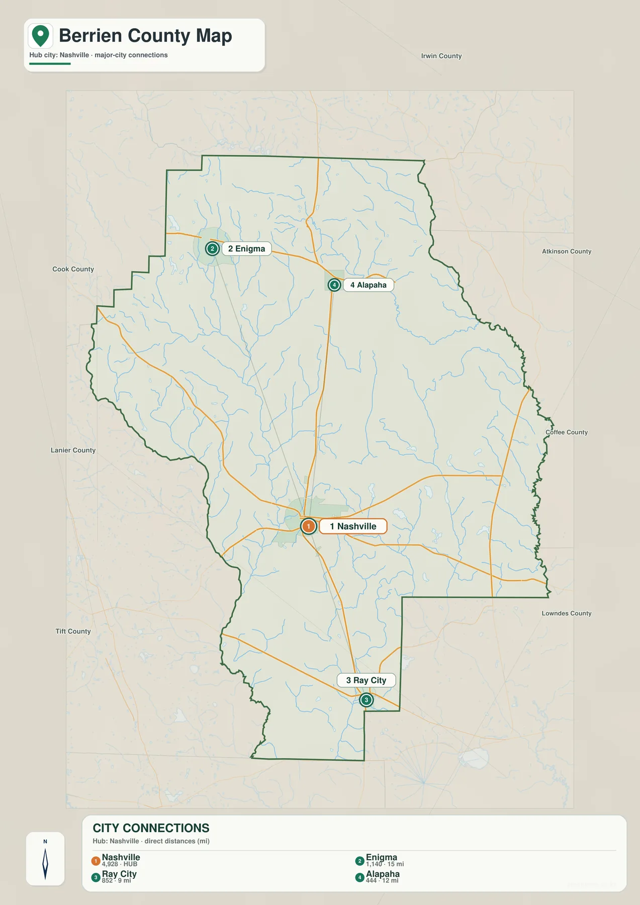
The map gives about 9 miles from Nashville to Ray City, 12 miles to Alapaha, and 15 miles to Enigma. Road travel can be longer because a driver has to follow the actual highway network, turn at intersections, and use available bridge crossings. For a report, lesson, or quick county profile, however, the straight-line values answer a useful question: which named place is closest to the county seat, and in which direction does it lie?
Putting the city map beside the road map adds the missing route context. Alapaha is not simply “north of Nashville”; it is also close to the U.S. 82/U.S. 129 junction and the Alapaha River area. Enigma lies west of Alapaha along the northern U.S. 82 corridor. Ray City is farther south near the lower end of the county outline, while Nashville is the point from which several state routes spread toward neighboring areas. The two maps therefore do different jobs without repeating the same information.
The historical background in the supplied county materials helps explain why these names remain important on a modern reference map. Berrien County was created in 1856 and named for John Macpherson Berrien. Nashville continues to serve as the county seat. The existing source material also notes incorporation dates and railroad-related development for Alapaha, Enigma, and Ray City. The present map is not a historical railroad map, but those records give context for why the four settlements became persistent local reference points within a largely rural county.
Alapaha River, creeks, lakes, and ponds
The terrain and water map shifts attention away from highways and toward the drainage network. In the north, Purvis Lake is labeled near a stream system that connects with Flat Creek and then the Alapaha River. The Alapaha is drawn as one of the strongest blue features on the page, bending across the northern and eastern side of the county. This makes it much easier to see the river as a physical feature than on the busier road map.
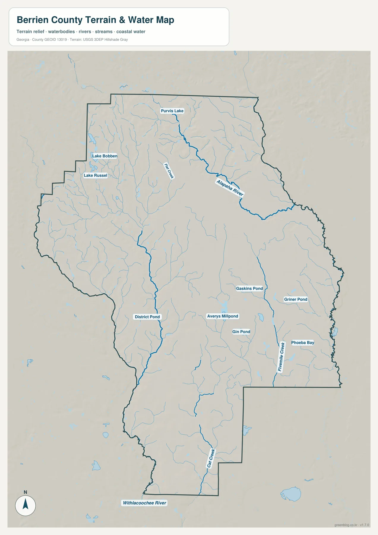
Several smaller named water bodies appear farther south and east. The map labels Gaskins Pond, Griner Pond, Averys Millpond, Gin Pond, and Phoeba Bay, with Fivemile Creek running through the southeastern side. Cat Creek is marked in the southern part of the county, and the Withlacoochee River is labeled just beyond the southern boundary. Lake Bobben and Lake Russel are shown in the northwest. These labels are useful because they show that local water geography is not limited to one large river; smaller creeks and pond systems are distributed across the county.
The supplied county sources also point to Paradise Public Fishing Area near the Enigma side and the Tift County line. Georgia DNR describes the property as 1,351 acres with 68 lakes covering about 525 acres. That concentration of managed lakes gives the northwest corner a distinctive water setting compared with the long Alapaha River corridor farther east. A reader interested in fishing, local recreation, or land-and-water relationships may therefore want to compare the DNR information with the broader county water map.
This is a reference map of water features and terrain, not a flood-hazard product. It does not identify safe boat launches, private-property access, flood elevations, wetland permits, or water depth. A blue line can show that a stream is present without showing whether a nearby road actually reaches it. For trip planning or site work, use current road information and the responsible local or state agency in addition to this county overview.
Elevation from 44 to 107 meters
The elevation map uses locally scaled terrain colors and shaded relief instead of place labels. Its legend reports an actual elevation range of about 44 to 107 meters, with a mean of 74 meters. Berrien is not a mountainous county, but that roughly sixty-meter range is enough to reveal clear differences between northern ridges, creek valleys, and the lower southern landscape.
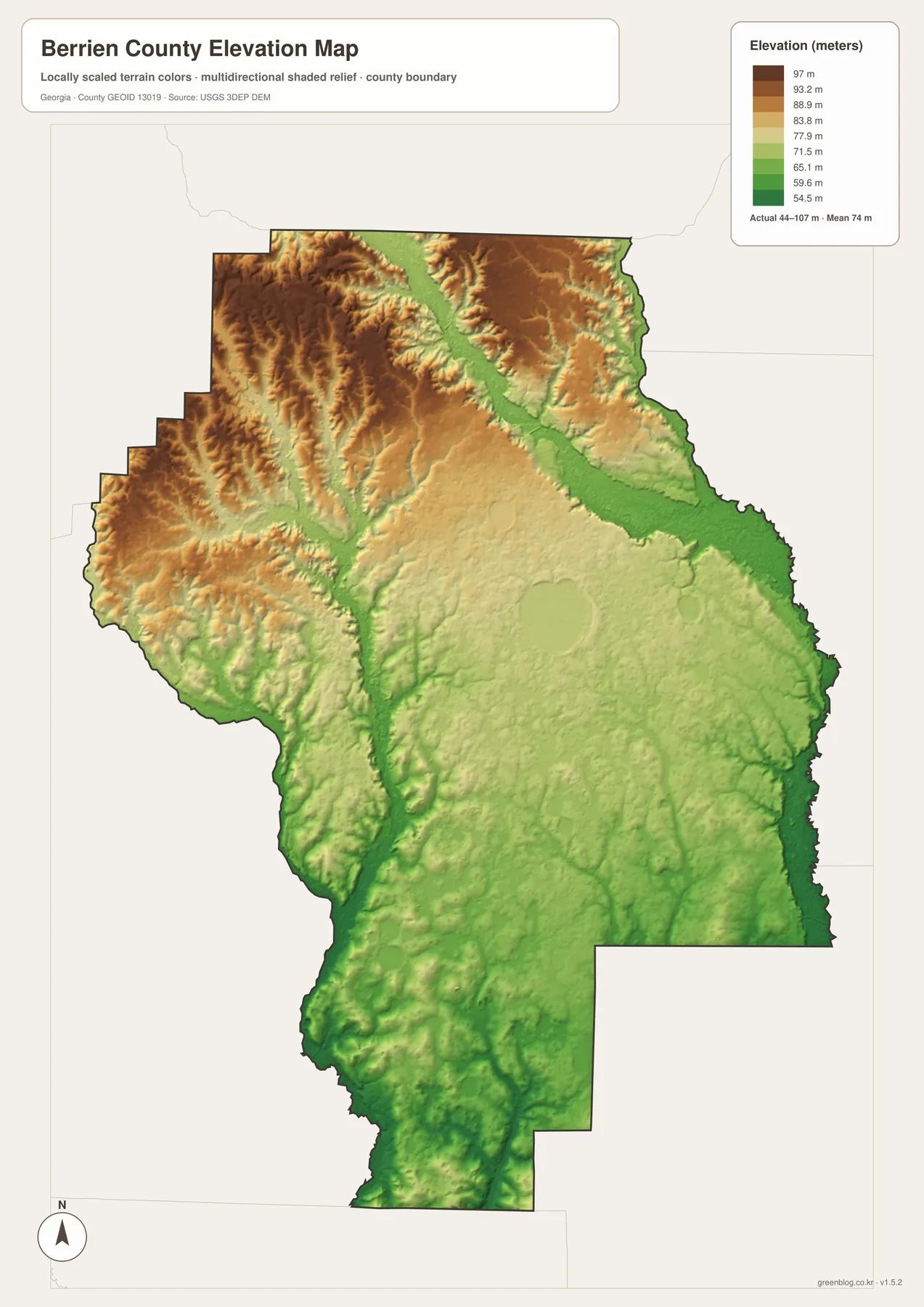
The most noticeable higher ground is in the northwestern and northern portions, where brown and tan ridges form a textured pattern. A broad lower strip runs through the north-central and eastern side in the same general area as the Alapaha River valley. Smaller low corridors also cut through the western ridges. Farther south, green shades become more extensive, indicating generally lower ground with less pronounced relief than the northern part of the county.
The relief becomes clearer when the stream corridors are considered alongside the shaded elevation surface. Waterways tend to occupy the lower strips between higher ground, and the northern part of the county shows more closely spaced ridges and small valleys. This helps explain why Berrien can look broadly level on a road map while still containing many local changes in height.
The elevation surface is generalized for county-scale viewing. It is not survey-grade elevation and should not be used to set building heights, calculate drainage engineering, or make parcel-level slope decisions. For those tasks, the underlying USGS elevation data and appropriate site measurements are more suitable. For education, regional comparison, or a concise explanation of why waterways follow certain low areas, the map provides the right level of detail.
Choosing the right Berrien County map file
Each map is most useful when matched to a specific question. Choose the county map when you need the outline, roads, named communities, and surrounding context on one page. Use the city-connections map when the main task is to compare Nashville with Alapaha, Enigma, and Ray City. The terrain and water version is clearer for rivers, creeks, lakes, and ponds, while the elevation version is the best choice for explaining higher northern ridges and lower drainage areas.
- County profile or presentation: start with the general county map for boundaries, Nashville, road numbers, and nearby context.
- Settlement comparison: use the city map for direction and straight-line distance from Nashville.
- Water-focused research: use the terrain and water map for the Alapaha River, named creeks, ponds, and lakes.
- Terrain explanation: use the elevation map to compare the 44–107 meter range and the contrast between northern ridges and lower southern areas.
For printing, keep the original A3 proportions so the map does not become stretched. When placing a JPG in a slide or document, lock the aspect ratio before resizing it. These files are designed as county reference graphics, so they work well for classroom handouts, local-history notes, planning discussions at a general scale, or a visual index for more detailed sources. For turn-by-turn travel, parcel boundaries, flood decisions, or engineering work, pair them with the current authoritative source for that specific task.
Frequently Asked Questions
Which communities are labeled on the Berrien County maps?
The main labels are Nashville, Alapaha, Enigma, and Ray City. Nashville is the county seat in the central-southern part of Berrien County, Alapaha is north of it, Enigma is in the northwest, and Ray City lies to the south. The maps are county-scale references rather than street maps, so they do not attempt to label every rural community or address.
Do the city-connection distances represent driving mileage?
No. They are straight-line distances measured from Nashville. The map shows about 9 miles to Ray City, 12 miles to Alapaha, and 15 miles to Enigma. Driving mileage will be different because a road trip must follow the available highway network, intersections, and bridge crossings.
What should I use for flood zones or engineering elevations?
Use current authoritative flood, survey, or engineering data for those decisions. The water map is meant to show the county-scale arrangement of rivers, creeks, lakes, and ponds, while the elevation map summarizes broad changes from about 44 to 107 meters. Neither image replaces parcel-level flood mapping, survey measurements, or site-specific design data.
Map File Information
Berrien County high-resolution A3 map files
- Included Files: county map, city-connections map, terrain and water map, and elevation map
- File Type: one ZIP containing four high-resolution A3 JPG files
- Intended Use: printing, education, presentations, local reference, and map-based projects
Related Maps
Sources and reference data
The county statistics, historical background, planning context, recreation information, and elevation reference can be checked through the following public sources. The map graphics are simplified for county-scale viewing, so the original agency data should take priority whenever a task requires greater precision or a current legal or operational decision.
- U.S. Census Bureau QuickFacts — population, land area, and basic county statistics
- New Georgia Encyclopedia: Berrien County — county formation and local history
- Georgia Department of Community Affairs planning records — joint planning context for Berrien and its municipalities
- Georgia Department of Natural Resources: Paradise Public Fishing Area — property and lake information
- USGS 3D Elevation Program — source program for elevation data
The statistical values above retain the reference year identified in the supplied county material. Facility descriptions can change, so current agency pages are the better source for operating information. These maps are intended to help a reader understand Berrien County quickly and choose an appropriate printable reference, not to replace official parcel, transportation, flood, or survey products.
Green Map creates custom-edited map images using open geographic data sources such as geoBoundaries, Natural Earth, OpenStreetMap, and government open data. These maps are edited visual materials, not raw data files, and are provided for education, documents, presentations, and graphic reference.