This page brings the Bibb County Georgia Map into four practical views of central Georgia: the county boundary and road network around Macon, the county’s main urban center, the Ocmulgee River and Lake Tobesofkee water system, and the elevation pattern from the river lowlands to the western hills. You can review the WEBP previews on the page and then download one ZIP containing four high-resolution A3 JPG maps for printing, classroom work, reports, presentations, or other county-reference projects.
Bibb County is easier to understand when Macon is treated as the starting point rather than as one label among many. Roads converge around the consolidated Macon-Bibb center, the Ocmulgee River defines a strong eastern natural corridor, and Lake Tobesofkee creates a very different water landmark on the west side. The elevation view adds another layer by showing higher, more broken ground across much of the west and northwest while the river corridor sits noticeably lower. The maps therefore work best as complementary references rather than as four copies of the same information.
Table of Contents
Macon, the County Boundary, and the Road Network
The county reference map outlines Bibb County in dark green and places the main roads, selected facilities, and nearby place labels inside and around that boundary. Macon-Bibb County sits near the center of the map, making it the easiest anchor for reading the rest of the county. Bolingbroke appears beyond the northwestern side, Montpelier (Historical) is labeled to the west, Goodall Estates is near the south, and Terrell appears on the east. Those labels are useful because Bibb’s boundary is irregular enough that a simple north-south description does not capture the whole shape.
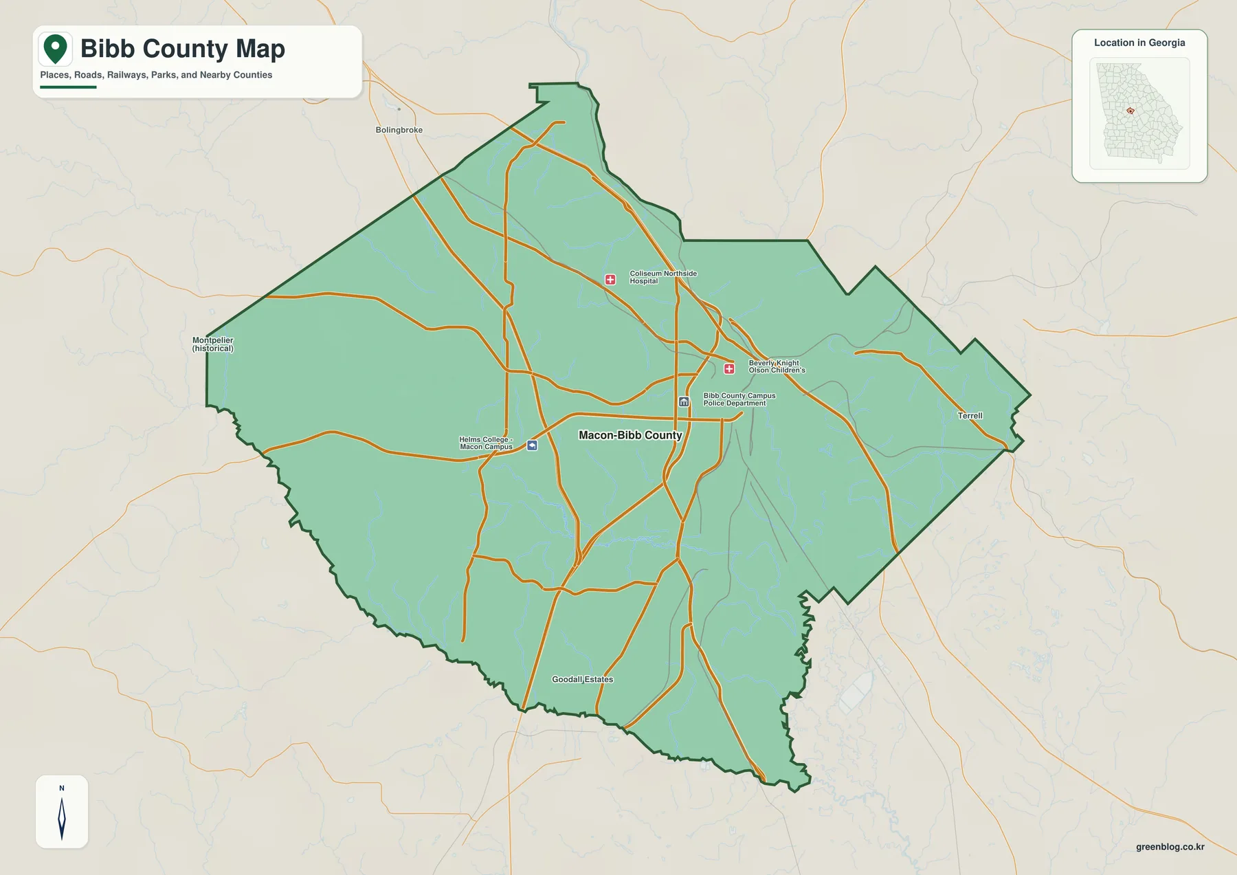
The older county material identifies three highways that help organize the more detailed road pattern. Interstate 75 crosses the county from north to south. Interstate 16 begins at its I-75 connection near Macon and continues east across the Ocmulgee River toward the Savannah corridor, while Interstate 475 bypasses the main urban core on the west and reconnects with I-75. Reading those routes first makes the map less crowded: I-75 provides the regional north-south spine, I-16 points east from Macon, and I-475 explains the major western bypass.
| State | Georgia |
|---|---|
| County | Bibb County |
| County seat | Macon |
| Established | December 9, 1822 |
| 2020 population | 157,346 |
| 2020 land area | 249.38 square miles |
| FIPS code | 13021 |
| Major water references | Ocmulgee River, Lake Tobesofkee, Tobesofkee Creek |
| Mapped elevation range | About 77–184 m, mean 117 m |
| Download | Four high-resolution A3 JPG maps in one ZIP |
The 2020 Census figures in the supplied material list 157,346 residents and 249.38 square miles of land. That population concentration helps explain why the map looks different from many lightly settled rural Georgia counties. Roads and institutional labels cluster around Macon instead of being spread among several equally prominent small towns. This map is therefore most useful for county orientation, road direction, and regional context; it is not intended to replace a street-level map for addresses, parcels, or turn-by-turn travel.
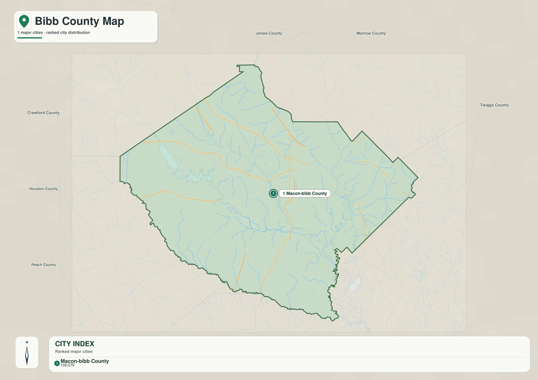
Bibb County borders Monroe and Jones counties on the northern side, Twiggs to the east, Houston and Peach to the south and southwest, and Crawford to the west. The city map prints those neighboring county names around the frame, which makes it easy to place Bibb within central Georgia. That surrounding context also explains why Macon serves as a regional connector rather than only a local county seat: traffic moving between the Atlanta side of the state, the Florida-bound corridor, and points east passes through or near this compact county.
Ocmulgee River, Lake Tobesofkee, and the Smaller Waterways
The water and terrain map shifts attention away from roads and toward the drainage network. The Ocmulgee River is the dominant feature on the eastern side, where its winding course is joined by smaller streams and branches. Boggy Branch, Swift Creek, and Stone Creek are labeled near the eastern river system, while Sawyer Lake and Edwards Lake appear nearby. This part of the map is especially useful for seeing how the river corridor occupies a broad low area rather than a single isolated blue line.
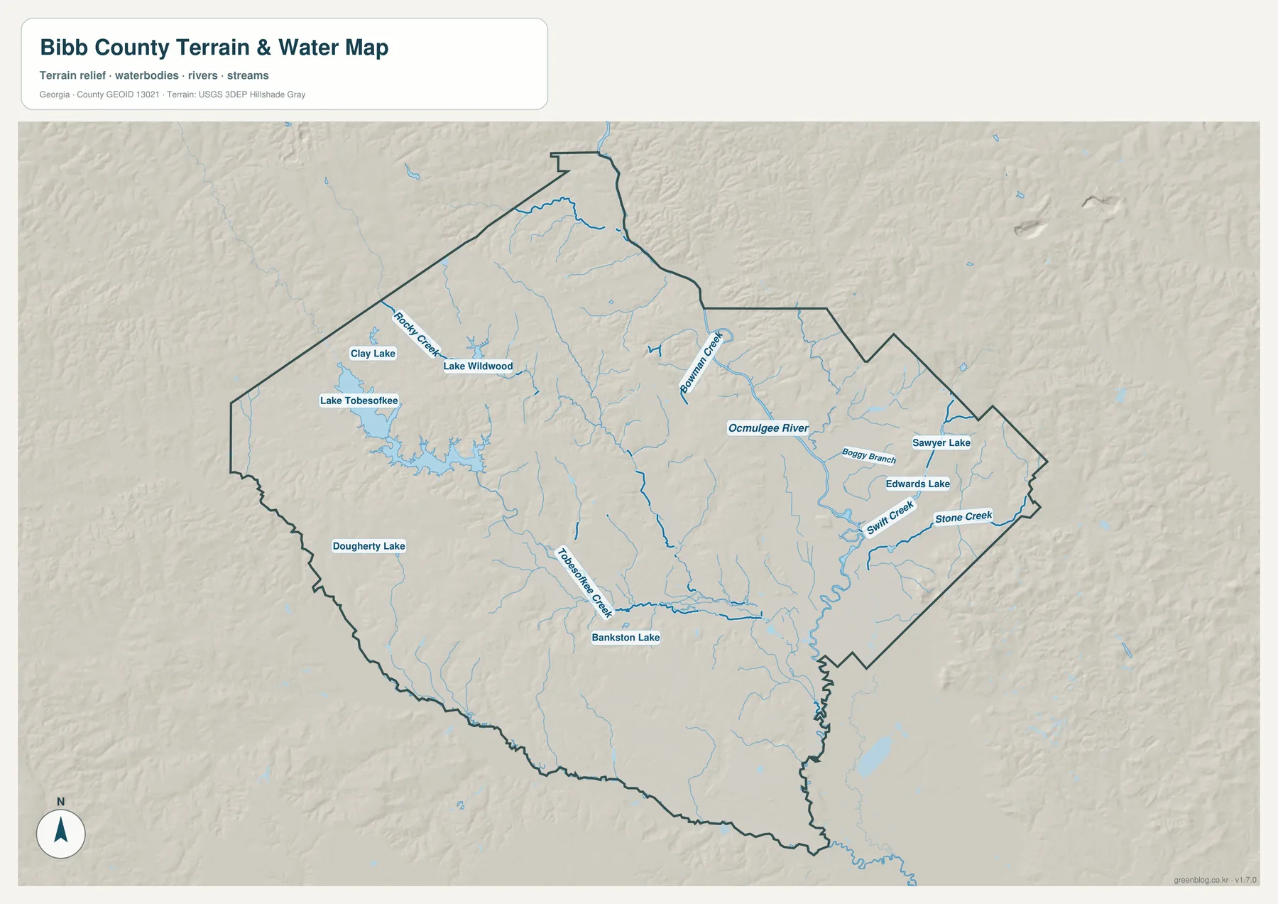
On the west side, Lake Tobesofkee is the largest named water body and is connected to a different landscape of creeks and smaller lakes. Clay Lake and Lake Wildwood sit farther north, Rocky Creek is labeled in the northwestern drainage, and Tobesofkee Creek runs through the west-central and southern part of the county. Bowman Creek appears to the north, while Bankston Lake and Daugherty Lake provide additional reference points in the southwest. These labels make the water map useful even when the reader already knows where the Ocmulgee River is located.
The supplied Macon-Bibb source describes Lake Tobesofkee as a recreation area of roughly 1,800 acres with about 35 miles of shoreline. The Ocmulgee side has a different character. South of the developed core, Bond Swamp National Wildlife Refuge protects floodplain habitat extending through Bibb and Twiggs counties. Looking at the two areas on the same map helps explain why “water in Bibb County” does not refer to one uniform setting: the western reservoir and the eastern river-floodplain corridor serve as very different geographic landmarks.
This is a reference map of visible water features and terrain, not a flood insurance map, navigation chart, parcel map, or access guide. A stream shown near a road does not guarantee a public crossing, and a lake label does not show boat ramps, depth, ownership, or current operating conditions. Flood risk, park access, and field travel should be checked against current information from the responsible agencies.
Why the City Map Centers on Macon-Bibb
The city-distribution map is intentionally simple. It shows Macon-Bibb County as the single ranked major urban center in the county index, rather than drawing several city-to-city connectors. Because only one major center is plotted, there are no connector lines or straight-line distance values to interpret on this particular map. Its value is in showing the position of Macon within the county boundary while leaving enough of the road and stream background visible to understand the surrounding geography.
That presentation also fits the county’s governmental history. After a 2012 referendum, the former City of Macon and Bibb County governments merged, and the consolidated Macon-Bibb government began operating on January 1, 2014. Older records may therefore use Macon, Bibb County, or Macon-Bibb in ways that reflect different administrative periods. When comparing historic maps, Census tables, or addresses, it is useful to check the date and the geographic unit instead of assuming every use of “Macon” covers exactly the same boundary.
For a reader who only needs to show where the main urban center lies, the city view is cleaner than the full county map. For road detail, selected facilities, and nearby place names, the county reference map is more informative. This distinction is important because the city map should not be read as evidence that nothing else exists outside Macon; it simply ranks and displays the major center according to the map’s city layer.
Elevation and the Fall Line Across Bibb County
The elevation map shows a countywide range of roughly 77 to 184 meters, with a mean of 117 meters. Browns and tan shades cover much of the higher, more dissected terrain in the west and northwest. Greens dominate the lower central and eastern areas, especially along the Ocmulgee corridor. Bibb County has no mountain range, but the relief is still strong enough to make the river valley and the western uplands look very different when roads and city labels are removed.
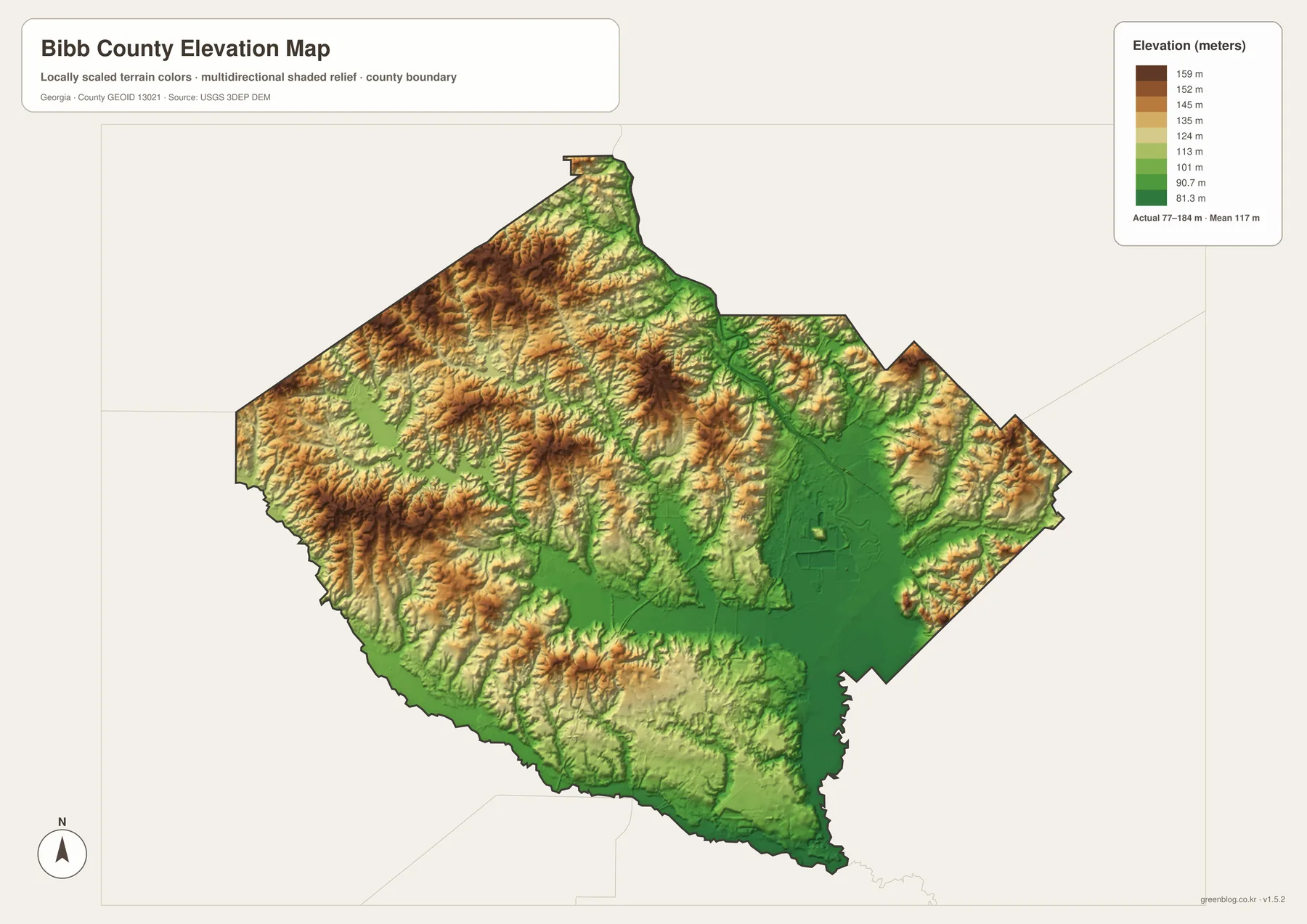
Macon lies on Georgia’s Fall Line, the transition between the Piedmont uplands and the Coastal Plain. The National Park Service source in the supplied material describes rocky shoals and rolling ground upstream of Macon, with broader floodplains, wetlands, swamps, and oxbow lakes becoming more characteristic downstream. The elevation surface makes that transition easier to visualize because the river follows a low corridor while ridges and hills rise more sharply to the west and northwest.
This terrain helped shape the city’s history as well. Riverboats could not simply continue upstream beyond the shoals, so Macon became an important transfer point. A rail connection toward Forsyth followed in 1838, and modern interstate routes later reinforced the same broad role as a transportation hub. Ocmulgee Mounds National Historical Park, east of the river, also demonstrates that the river crossing and Fall Line were important to human settlement long before Bibb County or the City of Macon was created.
The elevation colors are generalized for county-scale reading. They are useful for comparing the broad river lowland, western hills, and major valleys, but they should not be treated as survey elevations for a property, building site, drainage design, or engineering project. Those tasks require the original USGS elevation data and, when necessary, site-specific surveying.
Choosing the Right Bibb County Map File
Start with the question you need the map to answer. The county reference map is best when roads, the county edge, selected facilities, and Macon’s position need to appear together. The city map strips that information back to the main urban center. The water map is clearer for the Ocmulgee River, Lake Tobesofkee, creeks, lakes, and terrain, while the elevation map is the most direct way to compare the western hills with the lower river corridor. Using the appropriate view avoids forcing too many unrelated labels into a single figure.
- County orientation: use the main county map for the boundary, Macon, roads, selected places, and neighboring directions.
- Urban-center reference: use the city map when a clean view of Macon-Bibb’s position is more useful than road detail.
- Rivers and lakes: use the water map for the Ocmulgee River, Lake Tobesofkee, Tobesofkee Creek, and smaller named features.
- Terrain comparison: use the elevation map to show the 77–184 m range and the contrast between western uplands and eastern low ground.
The original JPG files are sized for high-resolution use, including A3 printing. Preserve the aspect ratio when placing them in a document or presentation so county boundaries are not distorted. For current road construction, street addresses, flood conditions, legal boundaries, park access, or engineering measurements, pair these reference maps with up-to-date information from the relevant public agency rather than relying on the map image alone.
Frequently Asked Questions
Why does the city map show only Macon-Bibb as the major center?
The city layer ranks Macon-Bibb as the county’s single major urban center, so this particular view does not draw multiple city connectors or distance lines. Smaller communities and neighborhood names are not being declared nonexistent; they simply fall outside the purpose of the ranked city layer. Use the main county map or a local street map when more detailed place labels are needed.
Can the water map be used to determine flood zones or public access?
No. It is designed to show the approximate county-scale location of the Ocmulgee River, Lake Tobesofkee, creeks, lakes, and related terrain. It does not show flood insurance zones, water depth, parcel ownership, boat ramps, bridge status, or guaranteed public access. Those questions require current maps and notices from the responsible agencies.
What does the 77–184 meter elevation range mean?
It is the overall range shown on the supplied Bibb County elevation surface, with a mean of about 117 meters. The map is well suited to explaining broad differences between higher western hills and the lower Ocmulgee corridor, but it is not survey-grade elevation for an individual parcel or construction site. Engineering work should use original elevation data and site-specific measurements.
Map File Information
The ZIP contains the four high-resolution A3 JPG versions used for county, city, water/terrain, and elevation reference.
- Included Files: county map, city map, terrain and water map, elevation map
- File Type: one ZIP containing four high-resolution A3 JPG files
- Intended Use: printing, classroom materials, reports, presentations, and county-reference projects
Related Maps
Sources and References
The links below support the population, county background, Fall Line setting, Lake Tobesofkee information, floodplain context, and elevation reference used in the article. The map graphics are simplified for county-scale reading, so current legal, operational, or engineering decisions should rely on the original agency material.
- U.S. Census Bureau QuickFacts — population and area reference for Bibb and Macon-Bibb
- New Georgia Encyclopedia: Bibb County — county formation, Macon history, Fall Line setting, and consolidation background
- National Park Service: Ocmulgee natural features — Fall Line and upstream/downstream river terrain
- Macon-Bibb County: Lake Tobesofkee — lake area and shoreline reference
- U.S. Fish and Wildlife Service: Bond Swamp — Ocmulgee floodplain and wetland habitat
- USGS 3D Elevation Program — elevation data background and limitations
Population and area values retain the reference year stated in the supplied material. Lake access, road conditions, park operations, and water conditions can change, so travelers and field users should check current agency information before relying on any static map.
Green Map creates custom-edited map images using open geographic data sources such as geoBoundaries, Natural Earth, OpenStreetMap, and government open data. These maps are edited visual materials, not raw data files, and are provided for education, documents, presentations, and graphic reference.