King County is easier to understand when the map is read from Guthrie outward rather than as a list of scattered place names. Guthrie sits near the center of the county map, while Dumont and Grow provide useful reference points toward the north. Routes 82 and 83 cross the county near Guthrie, and the water and elevation maps show why the surrounding landscape is much more varied than a simple road map suggests. The downloadable ZIP on this page contains the county, water, and elevation maps as high-resolution A3 JPG files.
The three supplied maps answer different practical questions without adding map types that are not present in the package. The county map is best for locating Guthrie and the numbered road network. The terrain-and-water map brings out the North Wichita River, Middle Fork Wichita River, South Wichita River, several creeks, and small reservoirs. The elevation map then shows a strong west-to-east contrast, with an actual mapped range of about 437 to 685 meters and a mean elevation of about 549 meters.
Table of Contents
Guthrie is the clearest starting point on the county map
Guthrie is the most useful anchor because it is clearly labeled near the middle of King County and serves as the county seat. From there, Route 82 runs generally east and west while Route 83 runs north and south. That crossing gives the map an immediate frame of reference. Dumont appears near the northwestern side of the mapped area and Grow is farther north, so even readers who do not know the county can quickly establish the main directions.
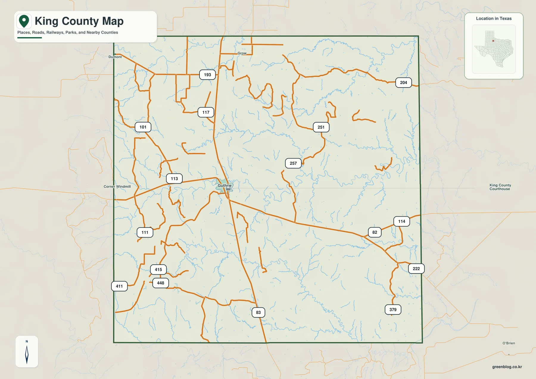
The map also labels many smaller numbered roads, including 101, 111, 113, 114, 117, 193, 204, 222, 251, 257, 379, 411, 415, and 448. Their value is not in memorizing every number. Instead, they show how access spreads away from Guthrie into a county where towns are few and distances between named places are relatively large. Several roads end, bend, or branch well away from the central crossroads, which makes the map useful for understanding local orientation before looking at more detailed navigation sources.
A sparse settlement pattern changes how the map is read
In a densely settled county, a reader can often move from one city label to the next. King County does not work that way. Guthrie is prominent, while Dumont and Grow are much smaller map references, and large spaces between them contain roads, drainage lines, and open terrain rather than a chain of urban places. That makes the road network more important to basic orientation than the number of town labels.
This is also why the county boundary is useful. Roads continue beyond it, but the boundary shows exactly where the King County page stops. For a classroom map, a simple exercise is to mark Guthrie first, trace Routes 82 and 83, and then note where smaller roads leave the county. For local research, that same sequence helps separate administrative location from the wider travel connections that continue into surrounding counties.
Three Wichita River branches dominate the water map
The terrain-and-water map changes the emphasis completely. Across the northern half, the North Wichita River, Middle Fork Wichita River, and South Wichita River form the largest named waterways. They do not appear as isolated blue lines. Numerous tributaries feed into or cross the same landscape, giving the county a dense network of draws and stream valleys that is easy to miss on the road map.
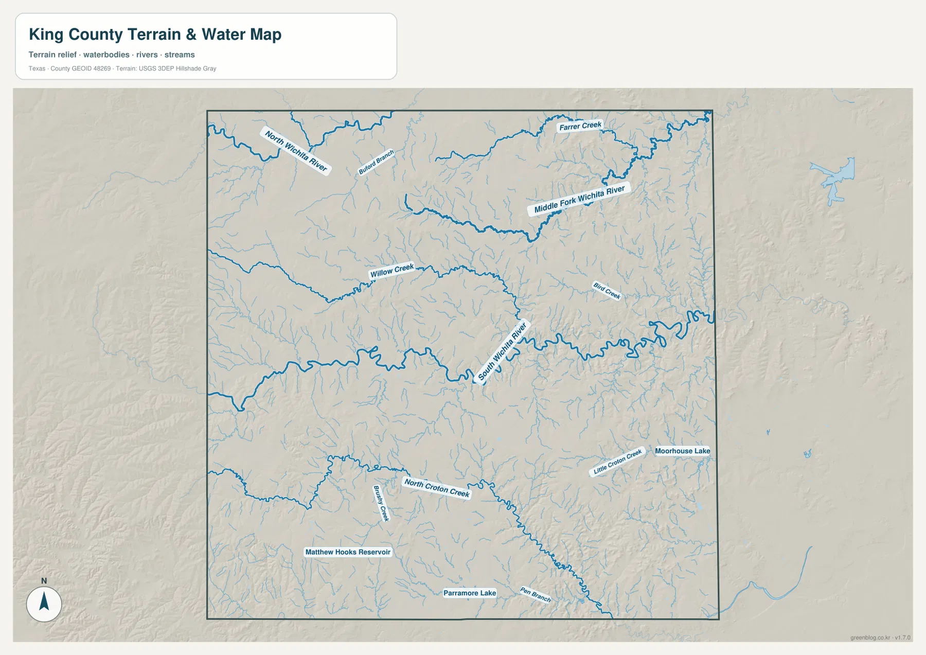
Willow Creek crosses the upper-middle part of the map, while Farrer Creek and Blufford Branch appear farther north. Bird Creek is labeled east of the central area. In the southern half, North Croton Creek is a major reference, joined by smaller names such as Bentley Creek, Little Croton Creek, and Pear Branch. The map also labels Moorhouse Lake, Matthew Hooks Reservoir, and Paramore Lake. Together, these features make it clear that surface drainage is distributed across many channels rather than concentrated in one single river corridor.
For general map use, the water layer is especially helpful when a road or place name alone does not explain the shape of the land. A winding stream can help identify a low corridor, while a reservoir provides a fixed reference that may be easier to recognize than an unnamed road. The map should not be treated as a flood-hazard or property-access map, however. Anyone making a safety, engineering, or land-access decision should check current official hydrology, road, and property information separately.
The elevation map shows a higher west and lower east
King County has a noticeable elevation contrast even though the map does not show mountains in the conventional sense. The elevation panel reports an actual range of about 437 to 685 meters, with a mean of about 549 meters. Browns and oranges are concentrated along the western side, while greens become more common toward the east. The shift is broad enough to see at a glance and provides a clear explanation for why the shaded relief looks more broken in some parts of the county than in others.
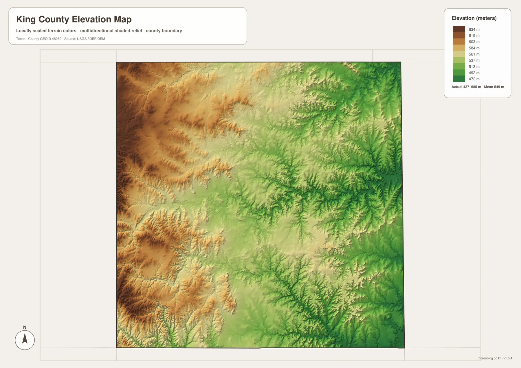
The shaded surface also reveals narrow incisions that line up visually with the stream-rich areas shown on the water map. This does not mean every green line or low area should be interpreted as a surveyed channel; the purpose of the elevation map is to compare broad relief across the county. For precise elevations, construction work, or boundary surveying, a specialized dataset and site-specific measurements are still necessary.
Choosing the right King County map for the task
The county map is the strongest choice for someone who needs Guthrie, the county boundary, and the road network in one view. The water map is better when the question involves the Wichita River branches, creeks, lakes, or reservoirs. The elevation map removes most place-name detail and instead makes the west-to-east change in height easy to compare. Looking at all three in sequence is useful because a road that seems isolated on the first map may sit next to a stream valley or a change in relief on the other two.
- County map: best for Guthrie, Dumont, Grow, the county boundary, and numbered roads.
- Terrain and water map: best for the Wichita River branches, Willow Creek, North Croton Creek, and the labeled lakes or reservoirs.
- Elevation map: best for comparing the roughly 437–685 meter range and the higher western terrain with the lower east.
Printing, classroom use, and local reference
For a printed handout, it is usually better to choose the map that matches the question instead of trying to place every type of information on one sheet. A road-and-place lesson can begin with the county map and Guthrie. A geography lesson about drainage can move to the water map and compare the North, Middle Fork, and South Wichita River labels. The elevation map works well for discussing why the western side appears higher and more rugged than much of the eastern side.
The downloadable archive contains the three supplied King County maps as high-resolution A3 JPG files. They can be used for personal study, classroom material, printing, or general location reference after reviewing the on-page versions above.
Frequently Asked Questions
What is the easiest place to find first on a King County map?
Start with Guthrie. It is labeled near the center of the county, and Routes 82 and 83 provide strong east-west and north-south references nearby. Once Guthrie is located, Dumont, Grow, and the smaller numbered roads are much easier to place.
Which waterways stand out most on the King County water map?
The North Wichita River, Middle Fork Wichita River, and South Wichita River are the largest named river references. Willow Creek and North Croton Creek are also useful because they help show how smaller drainage channels extend through different parts of the county.
What elevation range is shown for King County?
The supplied elevation map reports an actual range of about 437 to 685 meters and a mean of about 549 meters. The western side is generally higher, while lower elevations are more common toward the east.
Sources and Reference Data
For more detailed boundary, water, and elevation information, the following official sources provide the underlying types of geographic data used for county mapping. They are appropriate when a reader needs to go beyond the simplified presentation on this page.
- U.S. Census Bureau TIGER/Line Shapefiles — official geographic files for county boundaries, roads, and related features.
- USGS National Hydrography — official U.S. hydrography resources for rivers, streams, and other water features.
- USGS 3D Elevation Program — national elevation data and program information.
- USGS The National Map Viewer — interactive access to multiple official geographic layers.
Map File Information
The ZIP contains the King County county map, terrain-and-water map, and elevation map as high-resolution A3 JPG files.
- File Type: JPG files in a ZIP archive
Related Maps
- Stonewall County Texas map
- Motley County Texas map
- Wilbarger County Texas map
- Scurry County Texas map
- Baylor County Texas map
Green Map creates custom-edited map images using open geographic data sources such as geoBoundaries, Natural Earth, OpenStreetMap, and government open data.
These maps are edited visual materials, not raw data files, and are provided for education, documents, presentations, and graphic reference.