Kinney County in southwest Texas is easiest to understand when its roads, settlements, streams, and terrain are viewed together rather than as separate facts. The maps on this page show Brackettville and Spofford, the strong east-west line of U.S. 90, a dense network of creeks and river channels, and a clear rise in elevation toward the northern part of the county. After reviewing the maps on the page, you can download the matching high-resolution JPG files in one ZIP for printing, classroom work, regional comparison, or closer inspection of small labels.
The set contains a general county map, a simplified city map, a terrain-and-water map, and an elevation map. Each uses the same county boundary, so a location found on one image can be checked against the others without changing geographic frames. That is especially useful here because the map of settlements is sparse while the water and elevation layers contain much more detail. Instead of filling the page with generic county descriptions, the sections below stay focused on features that are actually visible in the supplied Kinney County maps.
Table of Contents
Brackettville and the Road Pattern Across Kinney County
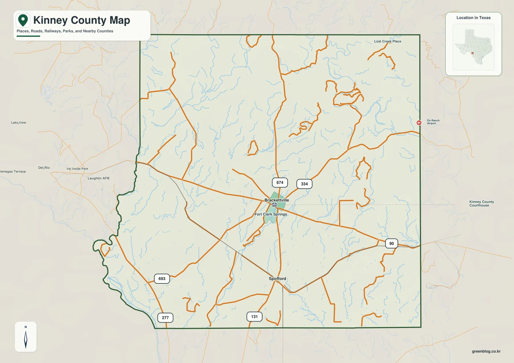
Brackettville is the clearest reference point on the general map. It sits a little east of the county’s center, where several roads come together, while Fort Clark Springs is labeled nearby. U.S. 90 forms the most obvious long-distance corridor, crossing the map from west to east through the Brackettville area and continuing beyond the county boundary. That single route makes it much easier to orient the rest of the map because other numbered roads can be read in relation to it rather than as isolated lines.
South of Brackettville, Spofford provides another useful point of reference. The map also marks U.S. 277 and Route 131 near the southern part of the county, along with roads numbered 693, 674, and 334 in other sections. These routes do not create a dense urban street grid. Instead, they cross large open areas and connect a small number of named places. The contrast between the concentrated road pattern around Brackettville and the wide spaces elsewhere is one of the most noticeable features of the county map.
The boundary itself also helps with orientation. Much of the north and east edge is relatively straight, while the southwest side has a more irregular outline. When the road network is viewed inside that shape, it becomes clear why Brackettville is a practical starting point for reading the county: it lies near the crossing of the strongest mapped routes, while other roads spread outward toward the edges.
A Simple View of Brackettville and Spofford
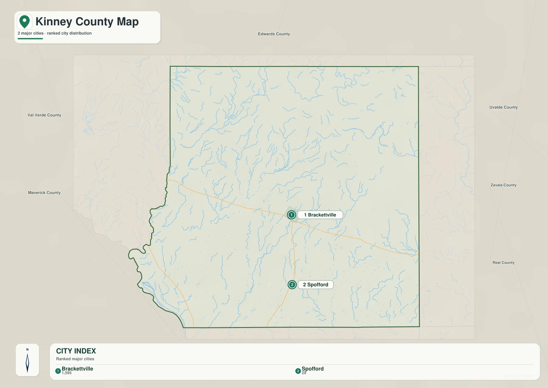
The city map deliberately removes most of the visual detail and ranks only two places: Brackettville and Spofford. Brackettville appears in the east-central part of the county, while Spofford is farther south. Because the map uses so few labels, the distance and direction between the two settlements are immediately apparent. This makes the city version useful for presentations, location diagrams, or any project where a full road network would be distracting.
Names of surrounding counties are placed outside the Kinney County boundary, including Edwards County, Uvalde County, Maverick County, and Val Verde County. They provide regional orientation without competing with the two ranked places inside the county. If the goal is simply to show where Brackettville and Spofford sit within Kinney County, this is the cleanest image in the set. If road numbers or smaller geographic features matter, the general county map or the water map provides the additional detail.
West Nueces River, Sycamore Creek, and the County’s Water Network
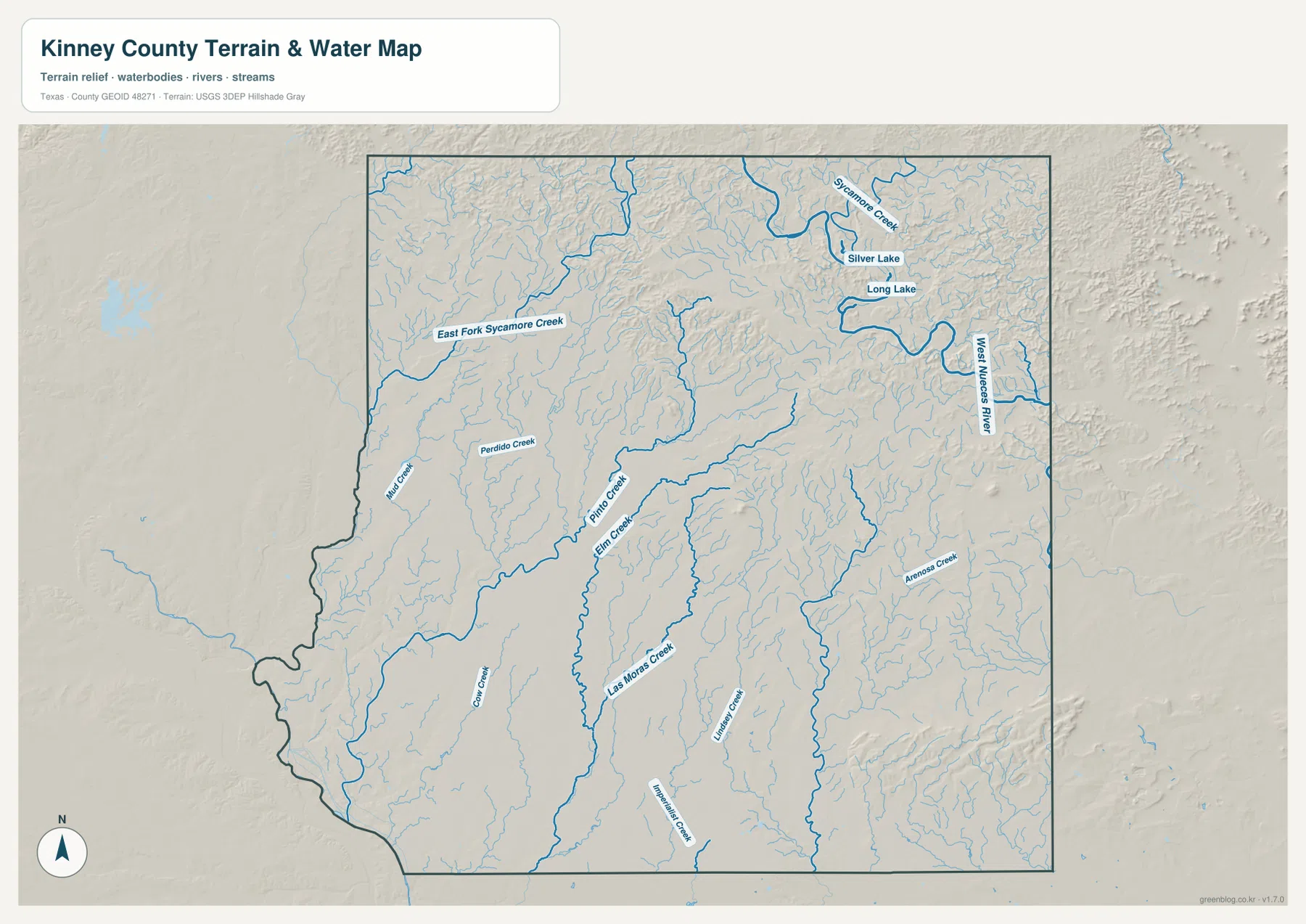
The terrain-and-water map changes the impression of Kinney County considerably. The general map has large areas with few place labels, but the hydrographic layer is filled with channels. In the northeast, the West Nueces River is one of the strongest named features. Sycamore Creek and East Fork Sycamore Creek appear farther north, and Silver Lake and Long Lake are labeled in the same broad part of the county. The numerous smaller tributaries around them make the northern landscape look much more dissected than the settlement map suggests.
Several other named creeks extend through the middle and southern sections. Las Moras Creek is a prominent north-south feature, with Pinto Creek and Elm Creek nearby. Perdido Creek and Mud Creek are labeled toward the west, while Arenosa Creek appears on the eastern side. These waterways are useful reference lines because they cross areas that otherwise contain few towns. A reader trying to understand an unlabeled part of the county can often orient it more easily by locating the nearest creek or river than by searching for a settlement name.
The water map also shows why it is helpful to keep terrain relief visible behind the blue channels. Streams do not run across a flat, featureless surface. They follow valleys and lower ground, and their branching pattern becomes denser where the relief is more pronounced. Comparing this map with the elevation image makes the relationship especially clear in the northern half of the county.
Elevation Rises Sharply Toward the North
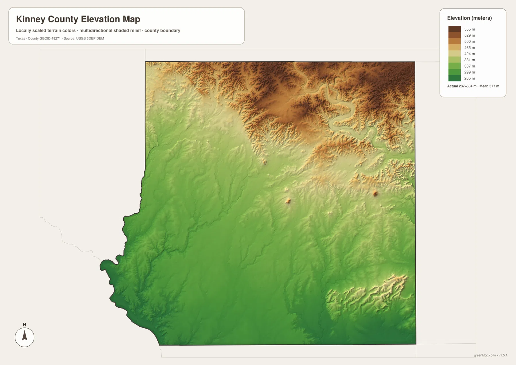
The elevation map gives an actual range of about 237 to 634 meters, with a mean near 377 meters. The color pattern is not evenly distributed. Green dominates the south and southwest, indicating the lower part of the county, while orange and brown spread across much of the north. Narrower green and yellow corridors cut into the higher terrain along valleys, producing a much more textured surface than the southern lowlands.
This north-south contrast is one of the most useful facts in the entire map set. It explains why the northern water network looks so branched and why the relief around Sycamore Creek and the West Nueces River is more pronounced. Farther south, lower elevations occupy broader areas. Las Moras Creek and other channels continue through that lower terrain, but the surrounding surface is generally less elevated than the northern section.
The elevation layer is therefore useful even when exact heights are not needed. For a classroom map, it can show that Kinney County is not uniformly flat. For regional comparison, it provides a quick way to separate the lower southern area from the higher northern terrain. And when paired with the water map, it gives physical context to streams that would otherwise appear as blue lines without an explanation for their paths.
What Becomes Clear When the Four Maps Are Compared
A practical way to use the set is to begin with Brackettville on the general map and trace U.S. 90 across the county. Next, use the city map to place Spofford to the south. The water map then adds West Nueces River, Las Moras Creek, Sycamore Creek, and the smaller channels that occupy the broad spaces between settlements. Finally, the elevation map shows that those same northern waterways lie within substantially higher and more broken terrain than much of the south.
This sequence is more informative than treating each image as a separate illustration. Around Brackettville, the road layer is the most useful because it shows how the county’s main settlement connects outward. In the north, the water and elevation layers carry more information than the city map because there are few ranked settlements but many valleys and streams. In the south, the lower terrain, Spofford, and the major road connections provide the clearest landmarks.
The maps can also be used independently. Someone preparing a simple locator graphic may need only the city image. A road-focused project can use the general county map. A lesson about drainage can focus on the terrain-and-water image, while an elevation comparison can use the color relief map. Because all four images share the same county outline, switching between them does not require learning a new frame of reference.
Choosing the Best Version for Print or Reference
Use the general county map when you need Brackettville, road numbers, and the overall boundary on one page. Choose the city map when the relationship between Brackettville and Spofford is the main point and extra labels would make the graphic harder to read. The water map is the better choice for named creeks, the West Nueces River, Silver Lake, and Long Lake. The elevation version is designed for comparing high and low terrain rather than locating towns.
The download below contains the high-resolution JPG versions of all four maps shown on this page. Keeping them together in one ZIP makes it possible to compare the same area at a larger size, print a single layer for a project, or retain the full set for later reference.
Frequently Asked Questions
Where are Brackettville and Spofford on the Kinney County map?
Brackettville is shown a little east of the county’s center, while Spofford is farther south. On the general map, Brackettville is also easy to identify because U.S. 90 and several other roads converge in its vicinity.
Which waterways are labeled on the Kinney County water map?
Prominent labels include the West Nueces River, Sycamore Creek, East Fork Sycamore Creek, Las Moras Creek, Pinto Creek, Elm Creek, Perdido Creek, and Arenosa Creek. Silver Lake and Long Lake are also labeled in the northeastern part of the map.
What elevation range is shown for Kinney County?
The supplied elevation map shows an actual range of about 237 to 634 meters and a mean of about 377 meters. The northern part of the county is generally higher, while the south and southwest contain broader areas of lower terrain.
Sources and Reference Data
- U.S. Census Bureau TIGER/Line Shapefiles – official boundary, road, and geographic reference data.
- USGS National Hydrography – official hydrographic data for rivers, streams, and water features.
- USGS 3D Elevation Program – official elevation and terrain data.
- USGS The National Map Viewer – an official viewer for comparing geographic layers.
Map File Information
Download four high-resolution A3 JPG maps of Kinney County in one ZIP file.
- Included Files: county map, city map, terrain and water map, elevation map
- File Type: JPG
Related Maps
- Uvalde County Texas map
- Val Verde County Texas map
- Real County Texas map
- Sutton County Texas map
- Zavala County Texas map
Green Map creates custom-edited map images using open geographic data sources such as geoBoundaries, Natural Earth, OpenStreetMap, and government open data.
These maps are edited visual materials, not raw data files, and are provided for education, documents, presentations, and graphic reference.