Morgan County in east-central Georgia has a distinctive wedge-shaped outline, with a narrow northern end and a much broader southern half. Madison, the county seat, sits near the center of the road network, while Rutledge lies to the west, Bostwick to the north, and Buckhead to the east. The maps on this page show those places together with major routes, a dense creek network, lakes, and a terrain range that runs from roughly 97 to 250 meters. After reviewing the WebP previews, you can download all four maps as high-resolution A3 JPG files in one ZIP.
The four views are most useful when they are compared rather than treated as duplicates. The county map is the clearest guide to Madison, I-20, the main route labels and the county boundary. The city map strips away much of that detail and shows straight-line connections from Madison to Buckhead, Rutledge, and Bostwick. The water map shifts attention to Hard Labor Creek, the Sandy and Indian creek systems, Little River, and several small lakes. Finally, the elevation map explains the broader terrain pattern: higher rolling ground is concentrated across the west and northwest, while lower valleys become more common toward the east and southeast.
Table of Contents
Madison anchors the I-20 and central road network
Madison is the easiest place to locate on the general county map. The Morgan County Courthouse and Morgan Medical Center are labeled close to the city, reinforcing its role as the county’s administrative and local-service center. I-20 crosses the western half of the county and passes near Madison, while route labels 278 and 12 approach from the Rutledge side. Route 83 comes up from the southwest, and the 24, 441, and 129 labels extend south from the Madison area. Even without every local street, the map makes it clear that Madison is where several of the county’s most visible transportation lines come together.
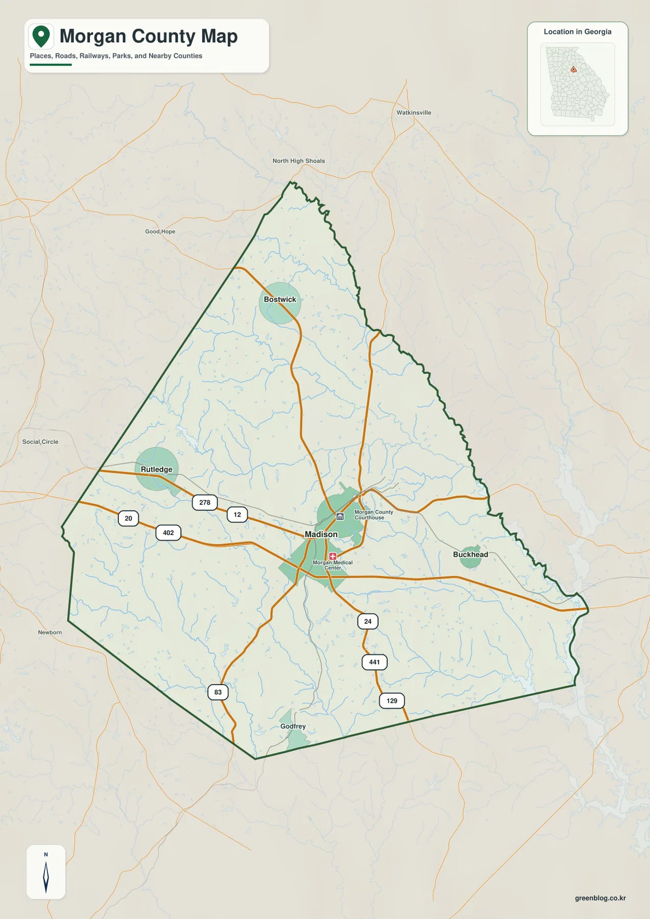
The other mapped towns occupy separate parts of the county rather than forming one continuous urban cluster. Rutledge is west of Madison near the main east-west route, Bostwick is farther north, and Buckhead sits to the east. Outside the county outline, the map also shows nearby reference names such as Watkinsville, North High Shoals, Good Hope, Social Circle, and Newborn. Those labels help place Morgan County within east-central Georgia, but the map is not intended to show every unincorporated community, every local road, parcel boundaries, or legal municipal limits.
Three town connections radiate from Madison
The city-connections map uses Madison as the hub and gives a simpler picture of the county’s settlement pattern. Buckhead is shown about 7 miles from Madison, Rutledge about 8 miles away, and Bostwick about 11 miles away. Those are direct straight-line distances printed on the map, not driving distances along public roads. That distinction matters because a route between two towns can be longer than the straight line shown here. For orientation, however, the distances quickly show that Buckhead and Rutledge are the nearer satellite towns while Bostwick sits farther to the north.
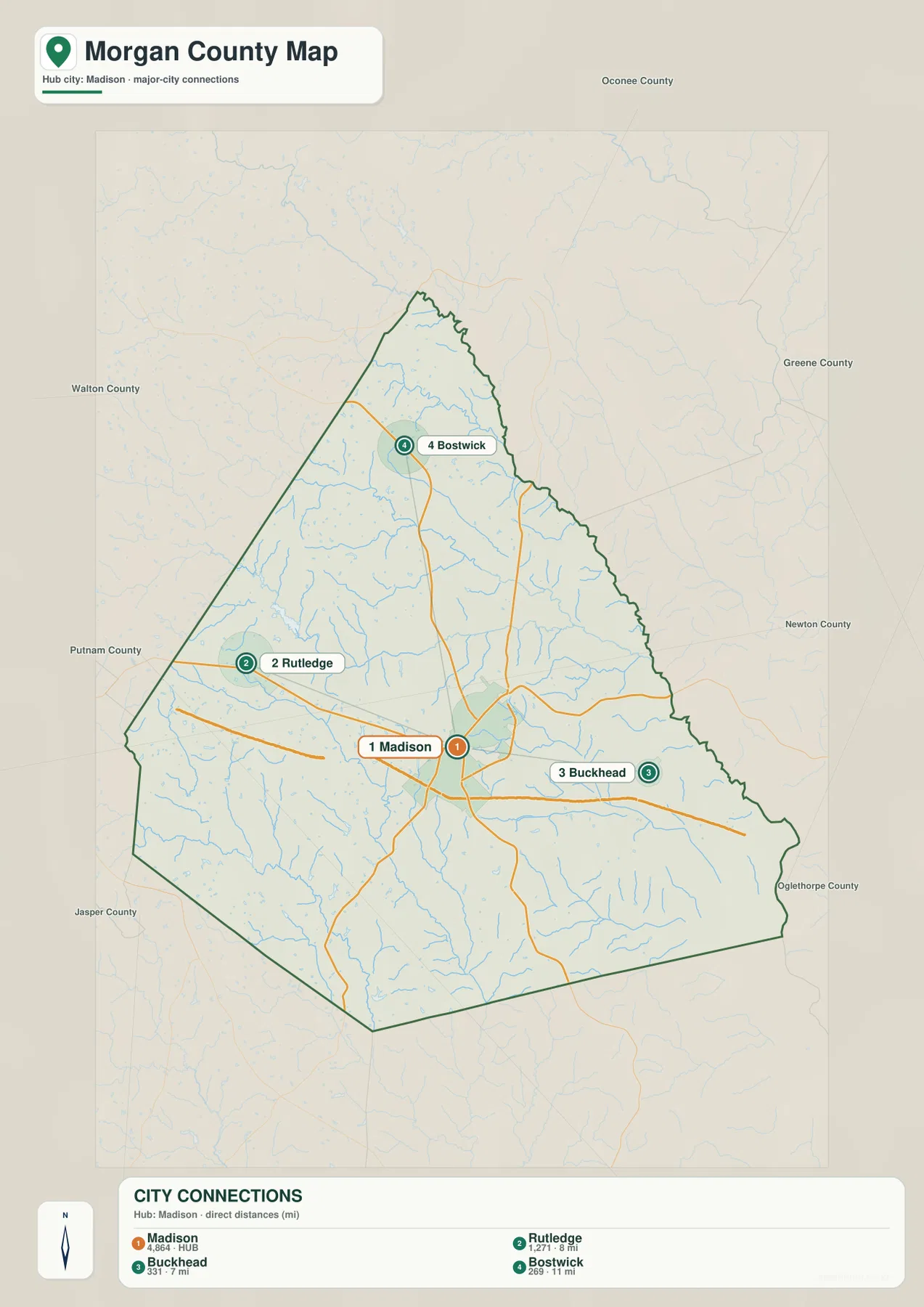
The map’s town index lists Madison at 4,864, Rutledge at 1,271, Buckhead at 331, and Bostwick at 269. Because the preview does not state the date attached to those displayed figures, they should be treated as part of the map’s ranking reference rather than as a substitute for a current Census estimate. Their relative positions are more important for this page. Rutledge provides a western reference along the road corridor, Buckhead marks the eastern side, and Bostwick gives the northern interior a clear named point.
| Mapped place | Position relative to Madison | Straight-line distance shown |
|---|---|---|
| Madison | County seat and hub | Reference point |
| Buckhead | East | About 7 mi |
| Rutledge | West | About 8 mi |
| Bostwick | North | About 11 mi |
Hard Labor Creek joins a dense Sandy and Indian creek network
The terrain-and-water map changes the character of the county completely by removing most road emphasis and making streams the main subject. Hard Labor Creek runs across the west-central area. Farther north, Big Sandy Creek and Little Sandy Creek are labeled, while Beaverdam Creek appears in the northern and northeastern interior. South of the county’s center, Big Indian Creek and Little Indian Creek form another prominent pair. Little River is labeled near the southern boundary, and Sugar Creek and Little Sugar Creek appear across the eastern and southeastern side.
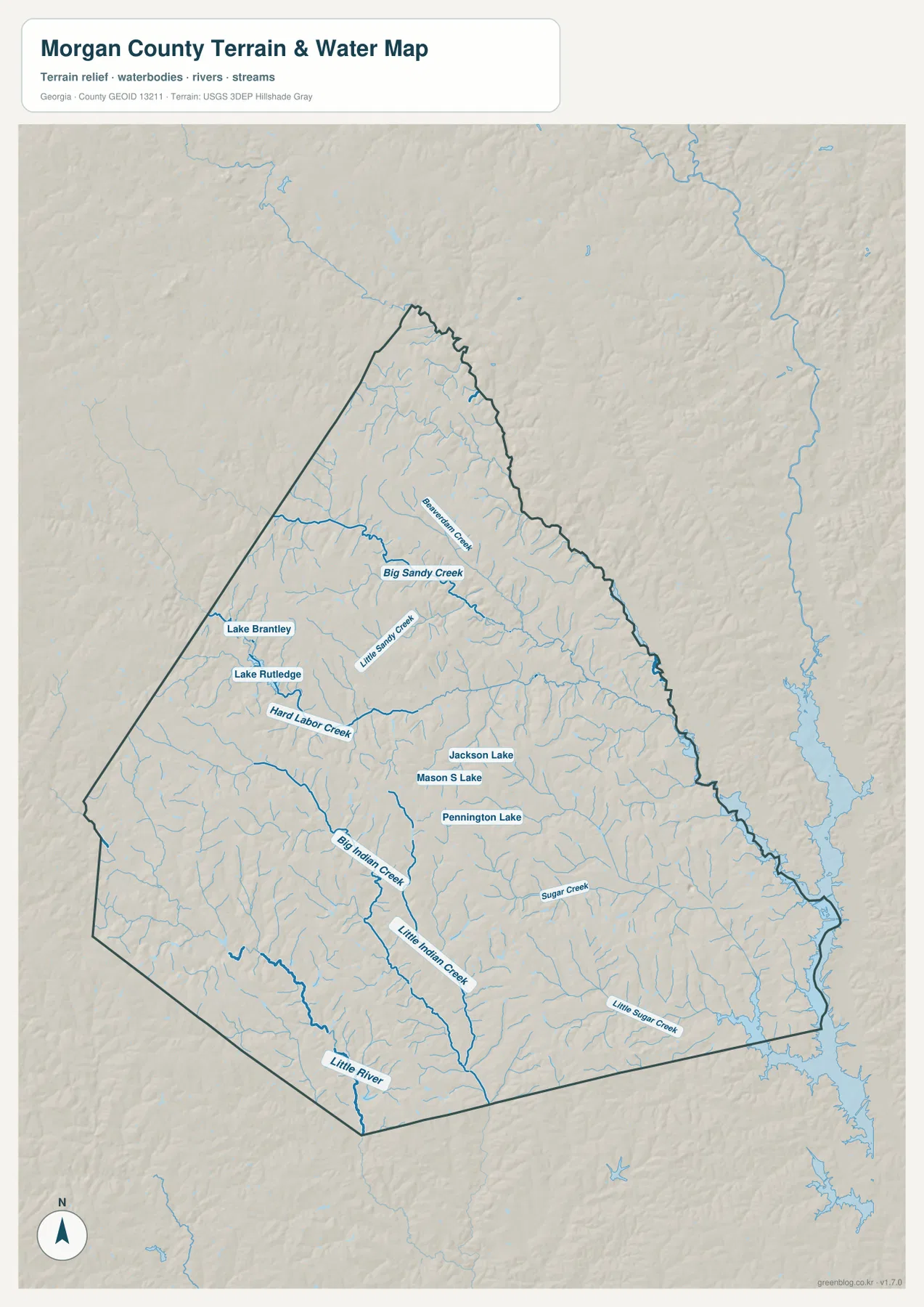
Several small lakes are labeled as well. Lake Brantley and Lake Rutledge appear on the western side, Jackson Lake and Mason S Lake are shown closer to the center, and Pennington Lake lies farther south. Together with the numerous unnamed tributaries, these features show that Morgan County is divided by many small drainage corridors rather than by one dominant river running through the middle. A reader following Hard Labor Creek can move north toward the Sandy Creek system or south toward the Indian Creek and Little River area and see how the county’s internal drainage changes from one section to another.
This water map is a geographic reference, not a flood-hazard, navigation, water-quality, or legal riparian-boundary product. Its best use is positional: locate a town or road on the general map, then compare the same part of the county on the water view to see the nearby creeks, lakes, and terrain relief. That comparison is especially helpful around the western half of Morgan County, where several named creeks and lakes sit close to the road corridor between Rutledge and Madison.
Elevation ranges from about 97 to 250 meters across rolling terrain
The elevation map reports an actual county range of roughly 97 to 250 meters and a mean elevation of about 185 meters. Brown and tan tones, which represent the higher parts of the local scale, cover much of the western and northwestern interior. Green tones become more common toward the east and southeast, where lower valleys occupy a larger share of the map. The narrow northern end also contains repeated ridges, while long green drainage corridors cut through the central and eastern sections. Rather than one isolated mountain, the county appears as a closely spaced pattern of small ridges and valleys.
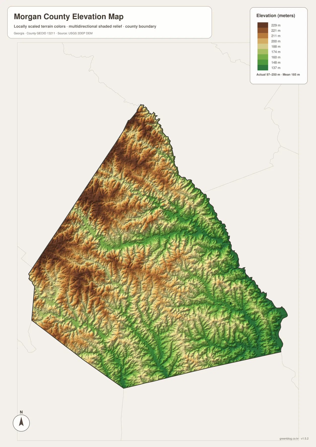
The elevation pattern becomes more meaningful when it is compared with the creek map. Big Sandy Creek, Hard Labor Creek, Big Indian Creek, and smaller tributaries occupy lower corridors between the surrounding ridges. The east and southeast show more green lowland, while the western side contains broader patches of higher brown terrain broken by narrow stream valleys. This generalized elevation surface is suitable for county-scale comparison, but it should not be used as survey-grade or engineering-grade height information for an individual property.
The county looks different when followed by roads instead of waterways
For a visitor trying to understand Morgan County quickly, the road network and the drainage network tell two different but complementary stories. The county map directs attention to Madison and the routes leading west to Rutledge, east toward Buckhead, north toward Bostwick, and south from the county seat. The water map ignores most of that travel structure and instead shows how Hard Labor Creek, the Sandy Creek system, the Indian Creek branches, and Little River divide the same landscape into smaller natural corridors. The elevation map then explains why those watercourses occupy narrow green valleys between higher ridges.
The contrast is easy to see west of Madison. On the general map, I-20 and the 278/12 corridor dominate the view toward Rutledge. On the elevation map, that same western area is largely higher rolling ground, while the water map reveals Hard Labor Creek, Lake Rutledge, and nearby tributaries cutting through it. East of Madison toward Buckhead, road connections remain simple, but the elevation view shifts toward lower green terrain. Comparing those areas across the map set is more informative than trying to force roads, town labels, streams, and relief onto one crowded image.
An 1807 county centered on Madison
The supplied existing county material identifies Morgan County as having been established in 1807 and names Madison as the county seat. It also points to historic architecture, agriculture, tourism, I-20, and Hard Labor Creek as useful parts of the county’s local context. Two of those features are directly visible in the map set: I-20 shapes the road view around Madison, while Hard Labor Creek stands out on the water map. The Morgan County government’s history page and the New Georgia Encyclopedia entry provide additional background for readers who want more than map orientation.
The maps here are designed for broad county reference rather than address-level or legal work. They do not replace turn-by-turn navigation, parcel records, municipal boundary files, flood studies, or precise site elevation measurements. They are well suited to classroom geography, local-history orientation, trip planning, reports, and presentations where the relationship among Madison, the smaller towns, major roads, creeks, lakes, and terrain needs to be understood at a glance.
Frequently Asked Questions
Are the 7, 8, and 11 mile city distances driving distances?
No. The city map labels straight-line distances from Madison: about 7 miles to Buckhead, 8 miles to Rutledge, and 11 miles to Bostwick. Actual road mileage depends on the route taken and should be checked with a current navigation service.
What waterways are shown besides Hard Labor Creek?
The water map also labels Big Sandy Creek, Little Sandy Creek, Big Indian Creek, Little Indian Creek, Little River, Sugar Creek, and Little Sugar Creek. Lake Rutledge, Pennington Lake, and several other small lakes are labeled as additional water references.
What is the main elevation contrast in Morgan County?
The map legend reports an actual range of about 97 to 250 meters and a mean of roughly 185 meters. Higher rolling ground is concentrated across much of the west and northwest, while lower valleys are more widespread in the east and southeast. The map is intended for county-scale terrain comparison, not precise property elevation.
Map File Information
If you need larger files than the WebP previews, the download ZIP contains four high-resolution A3 JPG maps covering the county, city connections, water features, and elevation.
- File Type: four high-resolution A3 JPG files in one ZIP
Related Maps
Sources and references
The following sources provide county background and authoritative reference data for boundaries, water, and elevation. The article itself prioritizes names and features that are visible in the supplied map package.
- Morgan County government’s history page
- U.S. Census Bureau QuickFacts
- New Georgia Encyclopedia entry for Morgan County
- U.S. Census Bureau TIGER/Line Shapefiles
- USGS National Hydrography
- USGS 3D Elevation Program
Green Map creates custom-edited map images using open geographic data sources such as geoBoundaries, Natural Earth, OpenStreetMap, and government open data. These maps are edited visual materials, not raw data files, and are provided for education, documents, presentations, and graphic reference.