Keweenaw County is one of the easiest Michigan counties to recognize on a map because its land is split into two very different pieces. The mainland portion occupies the northern end of the Keweenaw Peninsula, while Isle Royale lies far offshore in Lake Superior and is also part of the county. The maps on this page bring those pieces together with roads, settlements, rivers, inland lakes, and elevation. High-resolution JPG versions are available in the download box below for readers who need a larger printable file.
The county government describes Keweenaw as Michigan’s northernmost county, with Eagle River serving as the county seat. It is also sparsely populated: the 2020 Census counted 2,046 residents, and the Census Bureau’s 2025 estimate is 2,186. Those numbers help explain why a conventional “city map” does not tell the whole story here. Roads, shoreline, small communities, rivers, and long ridges are more useful geographic anchors than a dense urban network, especially once Isle Royale is included in the same county boundary.
Table of Contents
A county boundary that stretches across Lake Superior
The county map immediately shows a geographic pattern that can be confusing if the water is mistaken for land. The mainland section forms the northeastern end of the Keweenaw Peninsula. Far to the northwest, Isle Royale appears as a long, separate island, and a large part of the county boundary crosses open Lake Superior between the two. The broad polygon on the map therefore represents an administrative area, not one continuous landmass. For classroom use or regional orientation, that distinction is worth making before discussing roads or communities.
Along the southern edge of the mainland section, the county meets Houghton County. Calumet, Laurium, Lake Linden, and Hubbell appear just south of the line and provide useful reference points for entering Keweenaw County from the more populated part of the peninsula. Ahmeek sits near the southern gateway. Farther north and west, Eagle River and Eagle Harbor mark the Lake Superior side of the peninsula. The farther the map moves toward the tip, the more the pattern shifts from clustered settlements to shoreline, forested interior, streams, and small lakes.
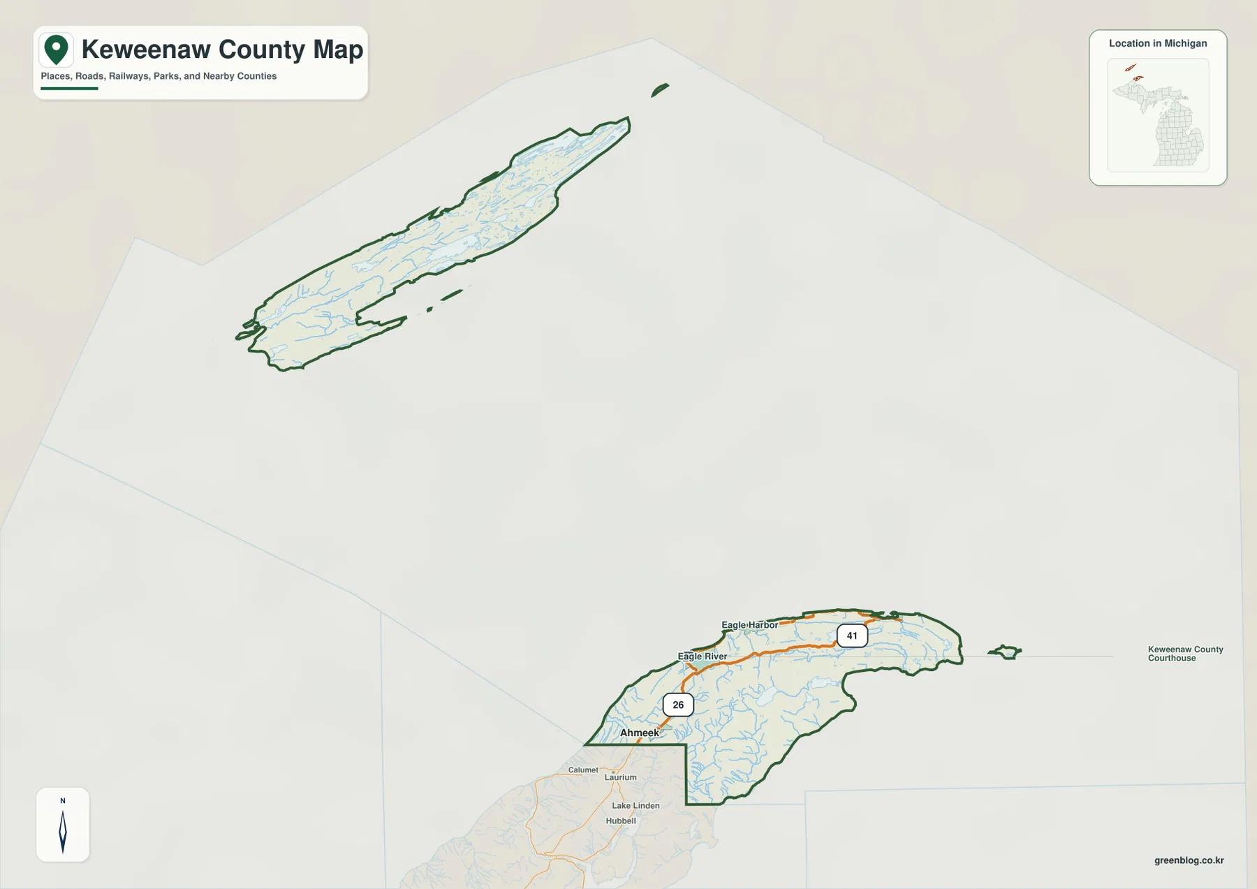
Isle Royale is not simply an inset or a nearby landmark. The National Park Service identifies Isle Royale National Park as being in Keweenaw County, Michigan. The island is more than 30 miles north of Michigan’s Upper Peninsula mainland and is reached by water or air rather than by road. That separation matters when reading the county map: US-41 and M-26 describe the mainland transportation pattern, while Isle Royale has a completely different access and settlement context. Treating the two pieces separately makes the county’s unusual shape much easier to understand.
US-41, M-26, and the small communities of the mainland
On the mainland, US-41 is the clearest north-south reference route. It enters the county near Ahmeek and continues through the interior toward the northern part of the peninsula. M-26 provides another important reference, especially along the western and northwestern Lake Superior side near Eagle River and Eagle Harbor. In a county with long distances between small communities, these highways give the map a practical framework. A reader can locate a town more quickly by asking which road and which side of the peninsula it is near instead of relying on a dense street grid that does not exist here.
Eagle River and Ahmeek illustrate why administrative importance and settlement ranking should not be treated as the same thing. Eagle River is the county seat and contains county offices. Ahmeek, however, is the settlement highlighted on the city distribution map, and county planning material describes it as the county’s only incorporated municipality. Other communities such as Eagle Harbor and Copper Harbor remain important geographic references even if they do not appear in the ranked city layer. The city map is therefore best read as a population-distribution aid, not as a complete list of meaningful places.
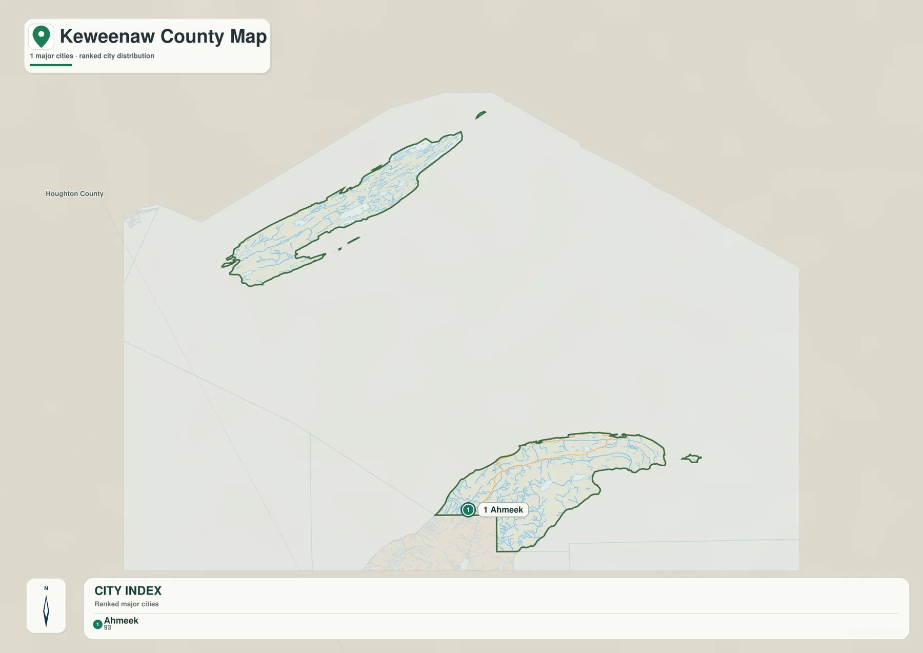
Because only one settlement is ranked, this city map does not draw connector lines or compare multiple city-to-city distances. There are no straight-line distance labels to interpret on this particular sheet. For driving orientation, the county map with US-41 and M-26 is the better companion. The city layer instead makes a different point: Keweenaw County does not have a large chain of urban centers. Its inhabited mainland places are small and widely spaced, while much of the mapped county consists of natural land, shoreline, or open Lake Superior.
Gratiot River, Montreal River, and a web of small inland waters
The terrain and water map adds detail that is easy to miss on the general county sheet. On the mainland, Gratiot River reaches Lake Superior on the western side, while Gratiot Lake and South Pond sit inland. Montreal River is visible farther east and north, and smaller features such as Owl Lake and Lost Lake help define the interior. The pattern is not dominated by one huge river crossing the county. Instead, numerous short streams and small basins occupy a narrow peninsula, with water moving toward different parts of the Lake Superior shoreline.
That arrangement makes the water map especially useful for understanding local orientation. Gratiot River provides a western reference, while Montreal River helps locate the northern shore. Gratiot Lake, Owl Lake, and Lost Lake show how inland water bodies are tucked among the ridges rather than arranged on a flat plain. Readers should not use this sheet as a flood map, parcel map, or navigation chart. It is a geographic reference for rivers, lakes, streams, coastal water, and surrounding terrain, so it is best for seeing how water features relate to the county’s shape.
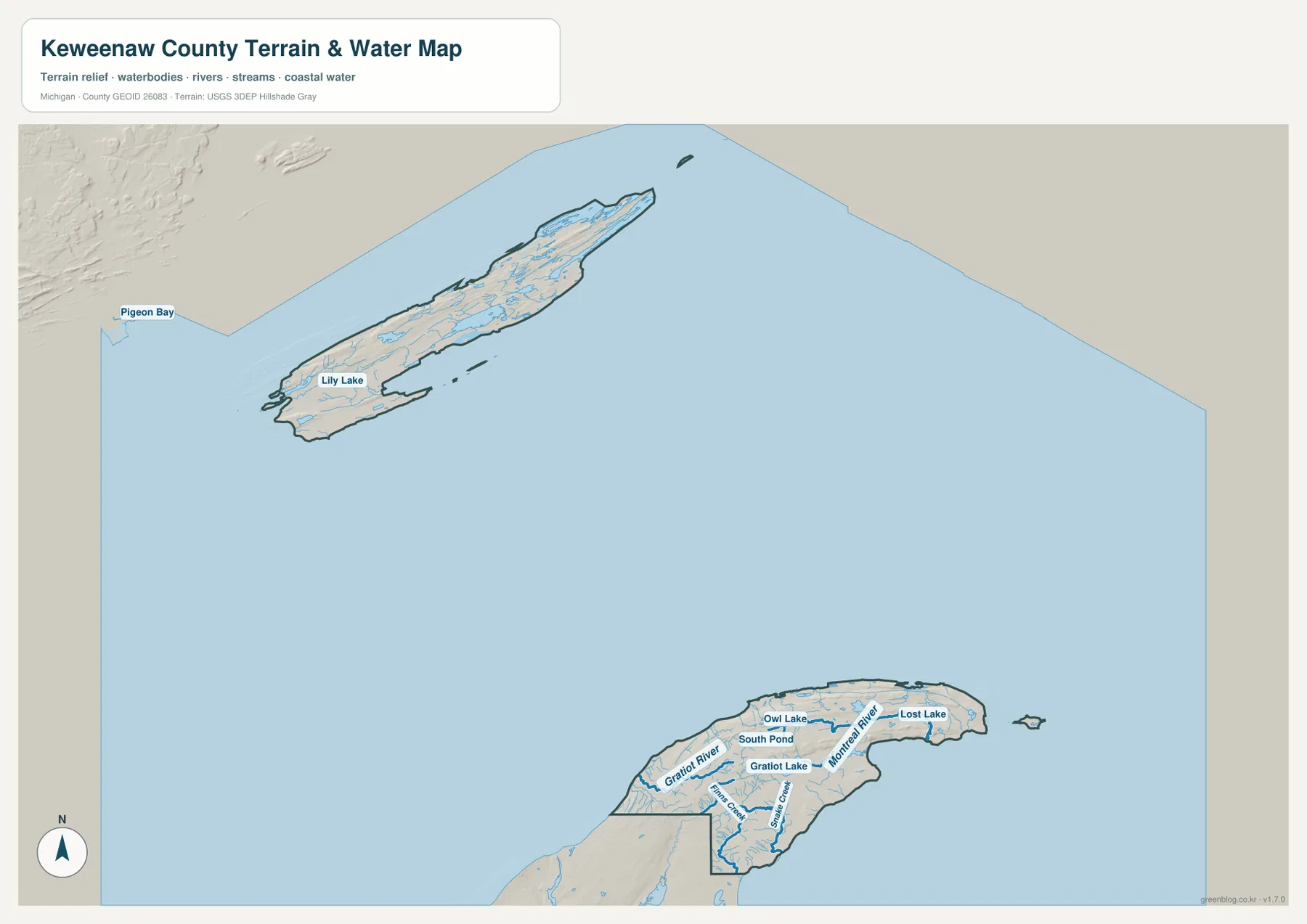
The Isle Royale portion adds a second water landscape. Lily Lake is labeled within the island, and Pigeon Bay appears near its western end on this map. The island’s long form is crossed by many small drainage lines, which fits the ridge-and-valley character described by the National Park Service. NPS geologic information explains that the island’s ridges, valleys, and inlets were shaped by bedrock structure and glacial processes. Even without turning the article into a geology lesson, that background helps explain why the water network looks elongated and broken into many smaller basins rather than broad lowland rivers.
Ridges stand out in the 183–464 meter elevation range
The elevation map strips away most road and place labels so that relief becomes the main subject. Its legend shows an elevation range of about 183 to 464 meters, with a mean near 254 meters. On the mainland, lower colors hug many coastal and valley areas, while a higher ridge runs through the interior. The relief is not a single mountain mass. It is a long sequence of higher ground and lower corridors that follows the shape of the peninsula, which is why the water map and the elevation map work particularly well as a pair.
Isle Royale shows the same strong lengthwise orientation. Higher ground forms an elongated spine through much of the island, with lower areas along shorelines and valleys. This is a generalized elevation surface designed for regional reading, not survey-grade measurement. It is suitable for comparing broad high and low areas, explaining why streams occupy certain valleys, or preparing a classroom map. It is not appropriate for engineering design, property-level grading, or any task that requires precise spot elevations.
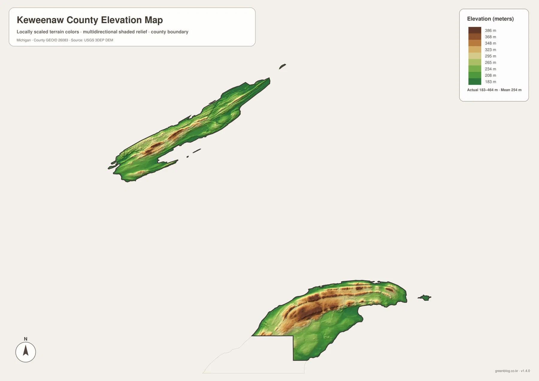
Comparing the elevation layer with the road map also prevents a common misunderstanding. US-41 and M-26 are transportation routes shaped by communities, shoreline access, and passable terrain; they are not lines that simply trace the highest ridges. Start with the county map to identify a road or settlement, then match the same location on the elevation map to see whether it sits near the coast, a valley, or higher interior ground. On Isle Royale, where there is no connected road network, the combination of ridges and water features becomes an even more important way to understand location.
Choosing the right Keweenaw map for the question
For a first look at the county, the general map is the strongest starting point because it explains the split between the mainland and Isle Royale while also showing the Houghton County boundary, US-41, M-26, Eagle River, Eagle Harbor, and Ahmeek. The city distribution map is useful when the question is settlement scale rather than transportation. The terrain and water map is better for rivers, inland lakes, and shoreline relationships, while the elevation map is the clearest choice for comparing ridges and lower ground.
Using all four maps at once is not always necessary. A lesson about why Keweenaw County looks discontinuous can rely mainly on the county overview. A discussion of Gratiot River and Montreal River should use the terrain and water map. A hiking or physical-geography explanation becomes clearer when the elevation sheet is added. Selecting the map that answers the specific question keeps labels readable and avoids repeating the same regional facts on every page.
When a larger image is needed, the downloadable archive contains the original 3638 × 2572 pixel JPG files that correspond to the four WebP maps shown in the article. These files are well suited to larger on-screen viewing, classroom handouts, and general printing. The map layers remain reference products, however. County and water boundaries, hydrography, and elevation are simplified for regional display and should not replace legal parcel records, flood regulation products, marine charts, or professional land surveys.
Frequently Asked Questions
Why does the Keweenaw County boundary appear in two separate land areas?
The mainland portion occupies the northern end of the Keweenaw Peninsula, while Isle Royale lies offshore in Lake Superior and is also part of Keweenaw County. A large amount of lake water lies between them, so a full county boundary looks much larger than the visible land. The correct way to read the map is as one county with separated land areas, not as one continuous peninsula extending all the way to Isle Royale.
Which map should I use to compare roads with elevation?
Use the general county map first to locate US-41, M-26, Ahmeek, Eagle River, or another reference point, then compare the same place on the elevation map. The road layer is better for orientation and travel corridors, while the elevation layer shows broad relief from roughly 183 to 464 meters. Neither map alone answers both questions as clearly as the pair.
Can the terrain and water map be used for flood risk or boating navigation?
No. It is a geographic reference showing rivers, lakes, streams, coastal water, and terrain. Features such as Gratiot River, Montreal River, Gratiot Lake, and Lost Lake can be located on it, but the map does not provide flood zones, channel depths, navigation hazards, or legal regulatory boundaries. Those decisions require specialized official products.
Sources and Reference Information
- Keweenaw County – About Our County: county seat, local communities, and county background.
- U.S. Census Bureau QuickFacts – Keweenaw County, Michigan: population and land-area statistics.
- National Park Service – Isle Royale Geodiversity Atlas: Isle Royale location and terrain background.
- USGS National Hydrography: hydrography reference.
- USGS 3D Elevation Program: elevation-data reference.
Map File Information
The ZIP contains the original high-resolution JPG files for the county map, city distribution map, terrain and water map, and elevation map. These are the full-size originals rather than the WebP images used in the article.
- Included Files: Use only the versions confirmed in the article and supplied images
- File Type: Use the confirmed download contents
- Intended Use: Printing, education, presentations, and map-based projects
Related Maps
Green Map creates custom-edited map images using open geographic data sources such as geoBoundaries, Natural Earth, OpenStreetMap, and government open data. These maps are edited visual materials, not raw data files, and are provided for education, documents, presentations, and graphic reference.