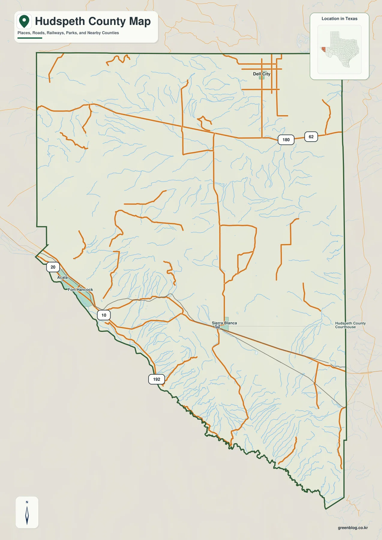
The Hudspeth County Map on this page comes with a downloadable ZIP of the same high-resolution JPG map files shown in the article. It covers the county boundary and roads, the city-distribution layer, named waterways and terrain, and elevation, so a visitor can move from Sierra Blanca and Fort Hancock in the south to Dell City in the north without treating this enormous West Texas county as if it were one compact urban area.
Hudspeth County is defined as much by distance as by labels. Sierra Blanca, the county seat, sits near the southern part of the county along Interstate 10. Fort Hancock and Acala lie farther west toward the Rio Grande side, while Dell City is separated from them by a broad interior of desert basins and mountain terrain. The maps make those gaps visible. They also show why the northern US 62/180 corridor and the southern I-10 corridor should be understood as different travel zones rather than as parallel streets in the same developed strip.
Table of Contents
Sierra Blanca, Fort Hancock, and Dell City are separated by large open distances
The county map places Sierra Blanca near the south-central portion of Hudspeth County and marks the Hudspeth County Courthouse nearby. Fort Hancock and Acala appear to the west along the Rio Grande side, with Interstate 10 and Texas 20 providing recognizable route references. Dell City is far to the northeast, where a local street grid stands out against the much more open county interior. This arrangement is important because the county seat is not centrally surrounded by a dense ring of towns. A trip between the northern and southern settlements crosses long stretches with few labeled communities.
The county outline reinforces that scale. El Paso County is on the west side and Culberson County lies to the east, while the southern edge follows the international-border side of the Rio Grande. Several roads enter or leave the county without creating a continuous urban corridor. For map users, the most useful first step is therefore to anchor each destination to a major route and a side of the county. Sierra Blanca and Fort Hancock belong to the southern travel pattern, while Dell City is tied to the northern route system.
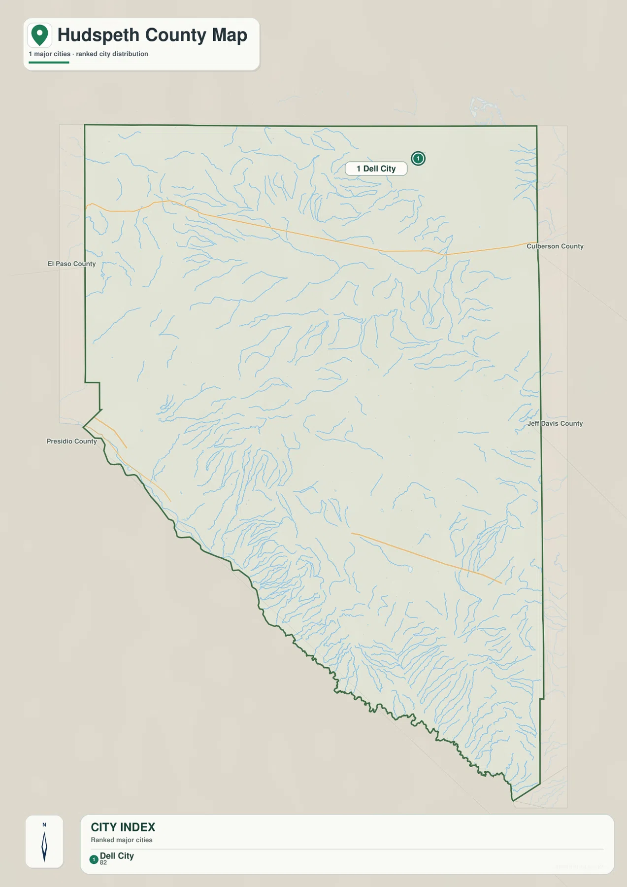
The city layer highlights Dell City, not the county seat
The city-distribution map has a narrower purpose than the general county map. Its CITY INDEX contains Dell City as the ranked major-city entry and places the matching marker in the northern part of the county. That should not be read as a statement that Dell City is the county seat. Sierra Blanca remains the administrative reference shown on the general map, while the city layer is using a different rule for which incorporated or ranked city entry it emphasizes. Seeing the two maps together prevents a common mistake: assuming that the place with the city marker must also be the county government center.
The Dell City marker is also a useful reminder of how much empty space lies between named settlements. The city map labels neighboring El Paso County, Culberson County, Jeff Davis County, and Presidio County around the edges. Those labels help orient the reader because many practical trips in a county this large continue toward a neighboring county rather than ending at another nearby town. The sparse distribution shown here is a county-specific feature, not a missing-data problem to be filled with invented places.
I-10 serves the south while US 62/180 crosses the north
Interstate 10 is the clearest long-distance route on the southern map. It enters from the Fort Hancock side, passes through Sierra Blanca, and continues east. Texas 20 appears near Fort Hancock and Acala, and Route 192 is marked closer to the international-border side. Around Sierra Blanca, north-south local roads meet the I-10 corridor, which makes the county seat a practical reference point for finding the southern part of Hudspeth County even though it is not close to every community.
The northern road pattern is different. US 62 and US 180 run across the upper portion of the county and connect with roads leading toward Dell City. Between that northern corridor and I-10 are broad areas of desert terrain with relatively few through routes. A traveler looking only at the county boundary might underestimate how separate these two systems are. On the map, however, the distance between Dell City and Sierra Blanca is obvious, and the road network shows that moving between them requires attention to the available crossings rather than simply following a dense local grid.
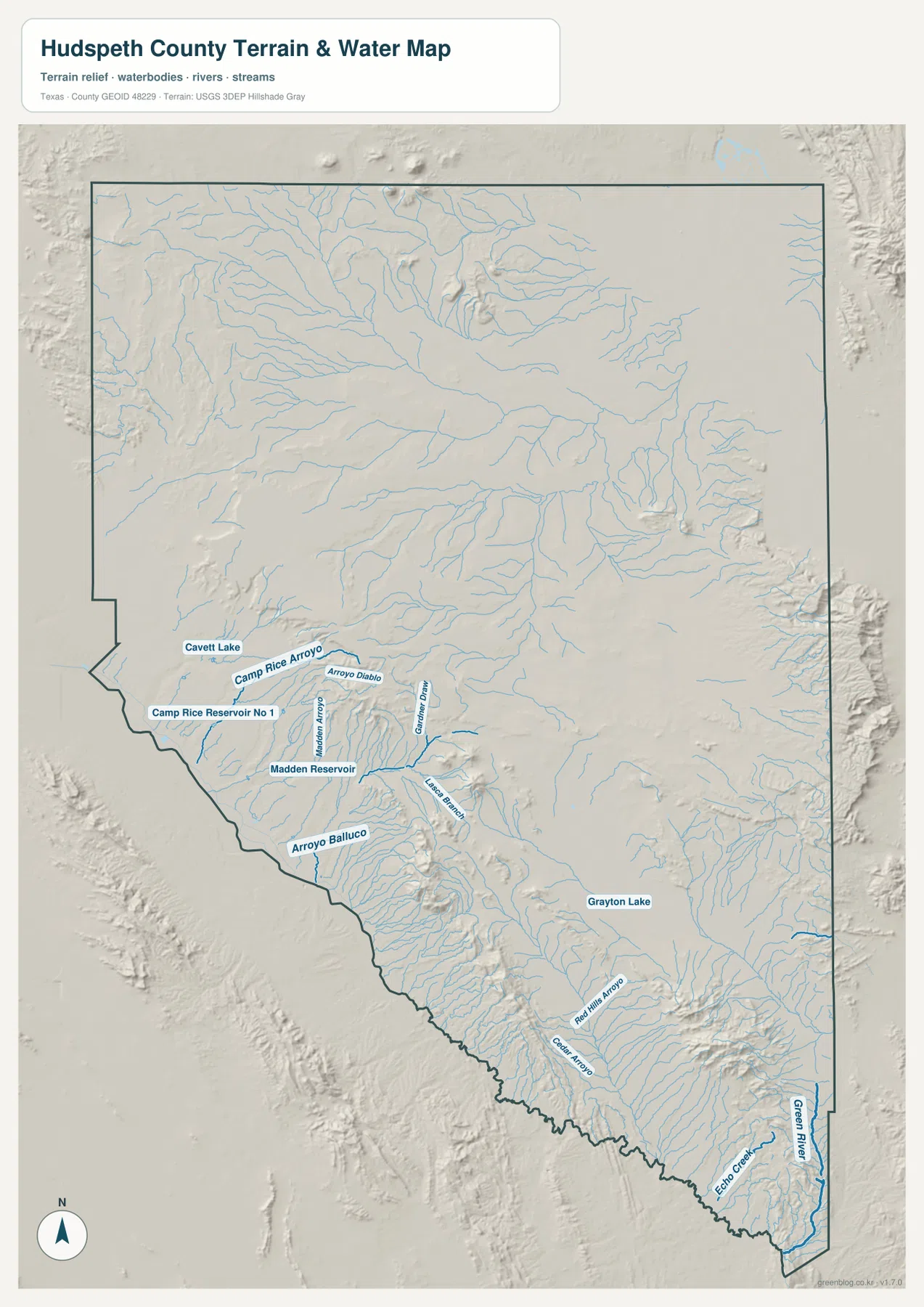
Arroyos and small reservoirs stand out on the Rio Grande side
The terrain-and-water map shows a surprisingly dense network of drainage lines for an arid county. Many short channels descend from higher ground toward lower basins and the Rio Grande side of the county. In the southwest, Camp Rice Arroyo and Arroyo Diablo are labeled near Camp Rice Reservoir No 1, Madden Reservoir, and Cavett Lake. Farther southeast, Red Hills Arroyo and Echo Creek are among the named features. Grayton Lake appears farther inland. These labels give the water map more local value than a simple blue-line overlay because they provide fixed points that can be matched against nearby relief.
The map should be used as a water-reference and terrain map, not as a flood-hazard or navigation product. Its strongest contribution is showing how numerous small channels relate to the mountain fronts and lower ground. Along the southern edge, drainage lines tend to converge toward the Rio Grande side, while elsewhere they spread across broad basins before collecting in larger channels or low areas. When this layer is compared with the road map, it becomes easier to see why some routes follow open low ground and why other parts of the county have fewer direct connections.
Elevation ranges from about 952 to 2,263 meters
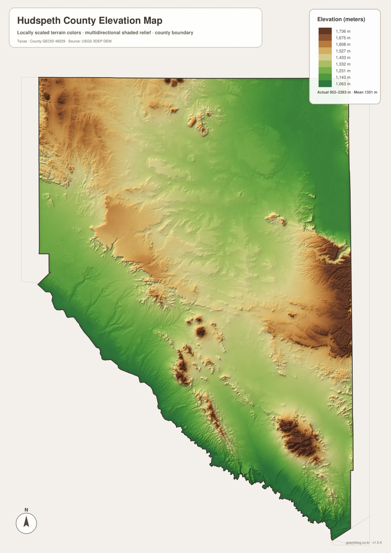
The elevation map reports an actual county range of about 952 to 2,263 meters and a mean near 1,351 meters. That spread of more than 1,300 meters is one of the clearest reasons not to describe Hudspeth County as uniformly flat desert. Green tones mark lower terrain, while yellow, tan, and brown identify progressively higher ground. Lower colors extend along much of the southwestern Rio Grande side, whereas high mountain blocks are especially prominent in the east and southeast. Smaller ridges and isolated high areas also appear in the northwest and interior.
The elevation layer helps connect the other maps. The drainage network becomes easier to understand when the reader can see the higher ground from which many arroyos descend. The road pattern also makes more sense where major routes stay within broad lower corridors instead of cutting straight across every ridge. The surface is generalized for county-scale comparison, however, so it should not be treated as survey-grade elevation for construction, property corners, or engineering design. For those purposes, a finer official elevation source or field survey is necessary.
Choose the map by the question you need to answer
For finding settlements and planning a basic route, the county map is the most practical starting point because Sierra Blanca, Fort Hancock, Acala, Dell City, and the principal highways appear together. The city layer is useful when the question is specifically about the ranked city entry and the position of Dell City. It adds context rather than replacing the general map, especially because the administrative center and the highlighted city are not the same place on these two layers.
For physical geography, the terrain-and-water map and the elevation map work best as a pair. The first names arroyos, reservoirs, lakes, and drainage lines; the second explains the large height differences behind those features. A classroom comparison can begin with I-10 and US 62/180, then add the drainage layer and finally the elevation colors to show how settlements, roads, water, and relief occupy different parts of the same county. Someone preparing a trip can use the same sequence to avoid assuming that two destinations inside Hudspeth County are necessarily close to one another.
The WebP images in the article are optimized for on-screen viewing. The download below contains the matching original high-resolution JPG files for the county map, city map, terrain-and-water map, and elevation map. Keeping the four files together makes it easier to print one layer, compare two side by side, or preserve the full set for later reference without saving each preview separately.
Frequently Asked Questions
Why does the city map highlight Dell City when Sierra Blanca is the county seat?
The city-distribution layer and the general county map are built to emphasize different information. Dell City is the ranked city entry shown in the CITY INDEX, while Sierra Blanca is the county-seat reference on the broader county map. The difference is useful rather than contradictory: one layer is highlighting a city entry, and the other provides administrative, settlement, and road context.
Do I-10 and US 62/180 serve the same part of Hudspeth County?
No. I-10 crosses the southern portion of the county through the Fort Hancock and Sierra Blanca side, while US 62/180 crosses the northern portion near the routes serving Dell City. Large open areas and mountain terrain separate the two corridors, so route planning should begin by identifying which side of the county contains the destination.
Can the 952–2,263 meter elevation range be used for engineering or property surveying?
It is appropriate for understanding county-scale relief, not for survey or engineering measurements. The map shows the broad contrast between lower Rio Grande-side terrain and much higher mountain areas, with a mean near 1,351 meters. A site-specific project should rely on higher-resolution official elevation data and, when required, a professional field survey.
Sources and Reference Data
For county-specific administrative information, the official Hudspeth County website provides the local government reference. The map data can also be checked against U.S. Census Bureau TIGER/Line Shapefiles for boundary and road geography, USGS National Hydrography for water-network reference data, and the USGS 3D Elevation Program for elevation data.
Map File Information
Download the high-resolution JPG originals for the Hudspeth County boundary and roads, city distribution, terrain and water, and elevation maps.
- Included Files: County map, city map, terrain and water map, elevation map
- File Type: JPG
Related Maps
- Reeves County Texas map
- Pecos County Texas map
- Presidio County Texas map
- Terrell County Texas map
- Ward County Texas map
Green Map creates custom-edited map images using open geographic data sources such as geoBoundaries, Natural Earth, OpenStreetMap, and government open data.
These maps are edited visual materials, not raw data files, and are provided for education, documents, presentations, and graphic reference.