Houston County sits at Alabama’s southeastern corner, with Dothan at the center of its road network, Georgia along the east, and Florida along the south. The county map makes the urban pattern easy to see, while the water and elevation views explain the quieter rural edges. This page includes four map views, and you can download the complete set as four high-resolution A3 JPG files in one ZIP from the file box below.
The maps are designed for different questions rather than as four copies of the same information. The county map combines places, roads, boundaries, and streams; the city map ranks six major cities and shows where they sit around Dothan; the water map pulls out named rivers and creeks; and the elevation map shows an actual range of about 25 to 115 meters. Together they make Houston County’s transition from a busy regional city to farms, creeks, and state-line countryside much easier to follow.
Table of Contents
Dothan, major roads, and two state-line edges
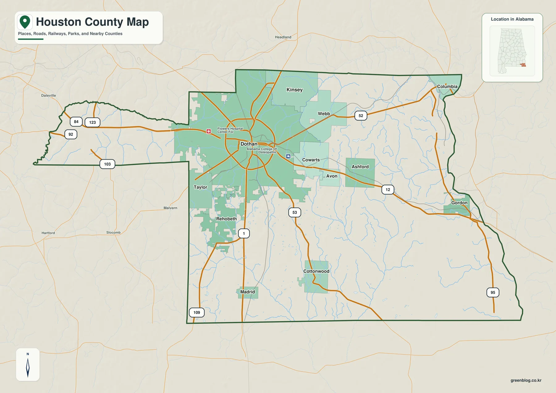
Dothan is the county seat and the dominant urban place on the main map. Its built-up area is much larger than the surrounding towns, and several major routes spread outward from the city. Taylor and Rehobeth sit to the southwest, Kinsey is just to the north, Cowarts lies east of the urban core, and Ashford is farther east toward the Georgia side. The map therefore works best when Dothan is used as the first reference point.
Three U.S. highways help organize the county. U.S. 231 links Dothan south toward Florida and northwest toward the Alabama interior. U.S. 84 crosses the city and continues east through the Cowarts-Ashford direction toward Georgia, while U.S. 431 leaves Dothan toward Headland and Henry County. The three routes explain why the city’s influence extends beyond the county boundary even though many outer communities remain small and rural.
The eastern outline is shaped by the Chattahoochee River rather than by a simple straight line. Columbia lies near the northeastern river edge and Gordon is farther south along the same Georgia-facing side. The southern county line, by contrast, is the Florida border. Cottonwood and Madrid provide useful southern reference points, while U.S. 231 is the clearest long-distance route toward the Florida Panhandle.
The western side has an unusual long extension toward Geneva and Dale counties. Part of the northwestern boundary follows the Little Choctawhatchee River, so the shape makes more sense when the road map and water map are compared. Houston County is not simply a rectangular corner county: waterways, neighboring counties, and the two state lines all contribute to its outline.
| State | Alabama |
|---|---|
| County | Houston County |
| County seat | Dothan |
| Major mapped highways | U.S. 231, U.S. 84, U.S. 431 and several Alabama routes |
| Border setting | Georgia on the east; Florida on the south; Henry, Dale, and Geneva counties to the north and west |
| Key mapped waters | Chattahoochee River, Choctawhatchee River, Little Choctawhatchee River, and multiple creeks |
| Elevation shown | About 25–115 m; mean about 66 m |
The supplied county material lists Dothan plus 11 incorporated towns: Ashford, Avon, Columbia, Cottonwood, Cowarts, Gordon, Kinsey, Madrid, Rehobeth, Taylor, and Webb. That list helps separate municipal names from other map labels. It also shows why the county can feel urban near Dothan while still containing many distinct small towns and broad rural areas near the outer edges.
Six-city map: a large Dothan core surrounded by smaller places
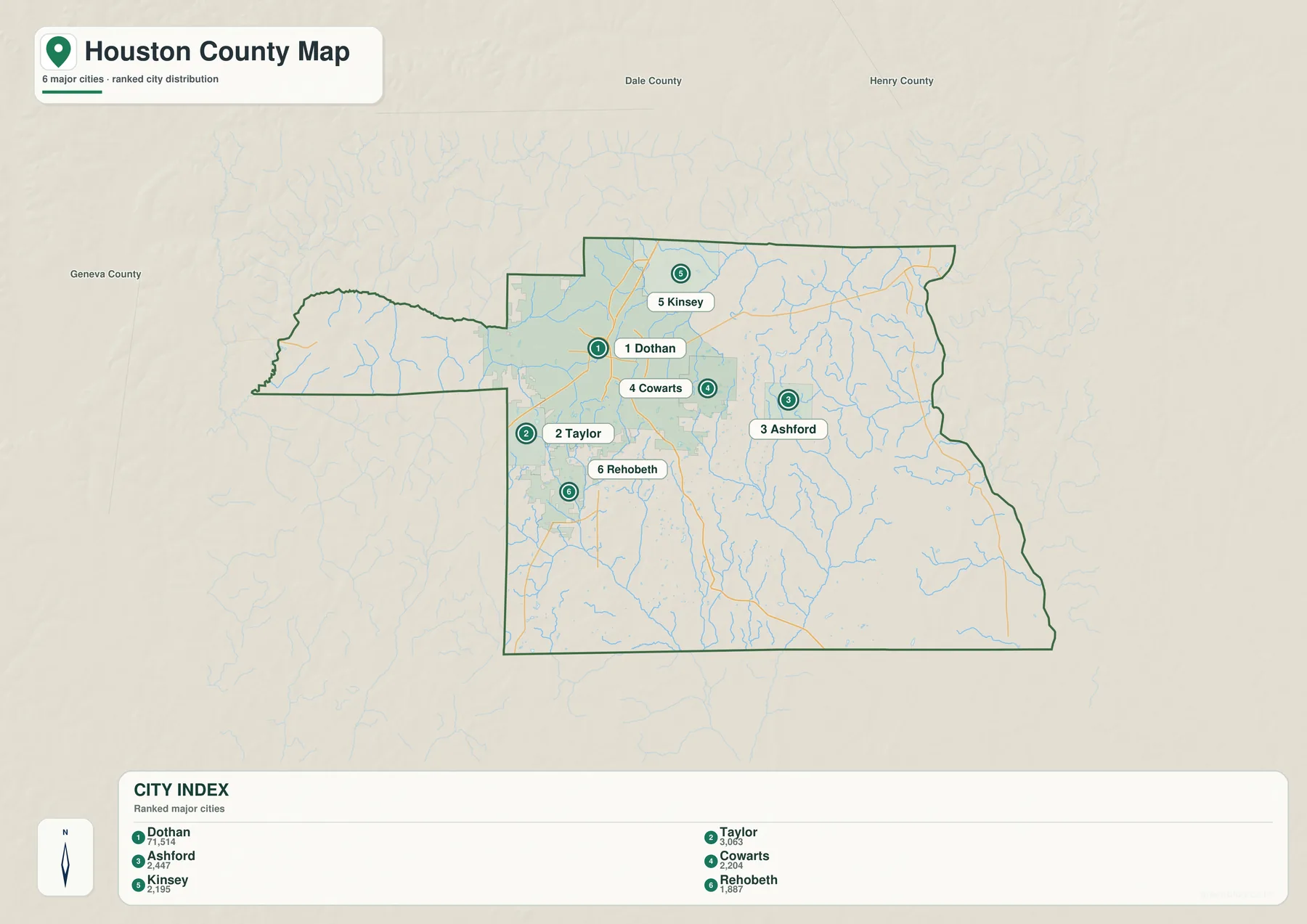
The city map deliberately narrows the view to six major places. Its printed index lists Dothan at 71,514, Taylor at 3,063, Ashford at 2,447, Cowarts at 2,204, Kinsey at 2,195, and Rehobeth at 1,887. These are the values embedded in the supplied map, so they are best treated as map-reference figures rather than a replacement for the latest official population release.
The scale difference is striking. Dothan’s urban footprint occupies a broad central area, while the five other ranked places appear as much smaller patches. Taylor and Rehobeth lie southwest of Dothan, Kinsey is to the north, Cowarts is on the east side, and Ashford is farther east. This arrangement makes the county look less like a chain of towns and more like one large service center with smaller municipalities spread around it.
Taylor and Rehobeth are especially useful for understanding the southwestern urban fringe. They sit close enough to Dothan that developed areas can appear nearly continuous in places, yet the names remain separate on the map. Cowarts plays a similar role on the east side. The map therefore distinguishes municipal identity even where daily travel and development tie the communities closely to Dothan.
Ashford is farther from the urban core and closer to the U.S. 84 corridor toward Georgia. Kinsey, meanwhile, lies north of Dothan near the route network leading toward Henry County. Comparing these positions with the main county map is more useful than reading the ranking alone because the roads show why different towns connect to Dothan from different directions.
The surrounding labels for Dale, Henry, and Geneva counties add one more layer of context. Dothan is close enough to multiple county lines that its service area does not stop at Houston County’s edge. The city map is still a Houston County map, but the broader labels help explain why the metropolitan pattern extends toward neighboring counties.
Chattahoochee water on the east and Choctawhatchee drainage to the northwest
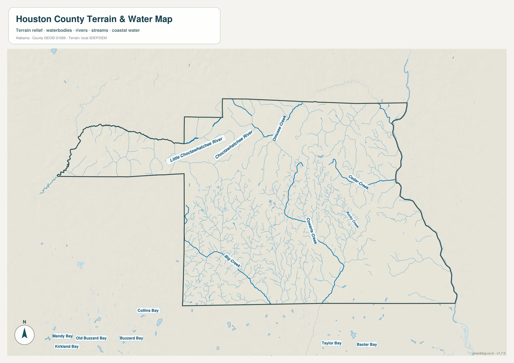
Houston County drains in more than one direction. The Chattahoochee River defines the Georgia-facing east, while the Little Choctawhatchee and Choctawhatchee rivers are prominent in the northwest. Inside the county, a dense network of small streams fills areas that look comparatively empty on a road map. The water map is therefore useful not only for finding named waterways but for seeing how frequently rural land is divided by creek valleys.
The Little Choctawhatchee River closely follows part of the county’s northwestern extension, and the Choctawhatchee River continues through the northern water network. Omussee Creek is another strong northern label. This part of the county also contains some of the higher rolling terrain shown on the elevation map, so the creeks appear as lower corridors cut between ridges rather than across a perfectly flat surface.
Cowarts Creek is one of the clearest inland streams and runs through the central-eastern countryside. Cedar Creek is farther east, while Hodges Creek appears between the larger systems. Around Ashford and Gordon, these streams help explain the natural pattern behind the road and settlement network. The Chattahoochee itself remains the largest boundary feature, but much of the county’s local landscape is shaped by smaller tributaries.
Big Creek stands out in the southwest, where numerous small branches also appear. The map extends beyond the county boundary and includes several bay names along the lower margin; those labels are background context, not evidence that every named bay lies inside Houston County. For county-specific use, the dark county outline is the safest guide to which water features are within the mapped boundary.
This is a location map, not a flood-risk or navigation chart. A blue line confirms that a stream or waterbody is mapped, but it does not show flood depth, legal access, ownership, or whether a channel is navigable. For those questions, a specialized official dataset is required. Here the main value is understanding how rivers and creeks fit around roads, towns, and the county line.
Elevation from 25 to 115 meters: higher northwest, lower southeast
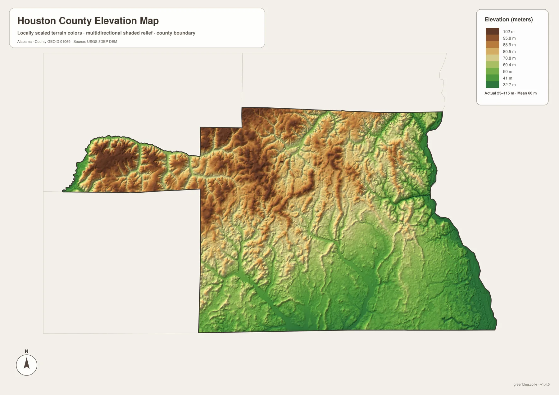
The legend reports an actual elevation range of about 25 to 115 meters and a mean near 66 meters. Houston County does not contain high mountains, yet the shaded relief makes clear that the land is not uniformly flat. Brown and tan ridges are most prominent across the western extension and northern part of the county, while broad green areas become more common toward the south and east.
The Chattahoochee side is consistently low, which matches the river boundary seen on the water map. Smaller green corridors also run inland along creeks, producing narrow low valleys between higher strips of ground. When the elevation and water maps are viewed together, many of the green fingers align with mapped streams, making the relationship between terrain and drainage easy to see.
The northwest and north-central sections show the strongest rolling texture. Higher ground is broken repeatedly by the Little Choctawhatchee, Choctawhatchee, and their tributaries. The western extension is similarly varied: its edges drop toward stream courses, while elevated ridges remain between them. The result is a landscape of low creek corridors and short uplands rather than one broad plateau.
Around Dothan, the terrain is generally moderate and less rugged than the highest northern ridges. Farther southeast, lower green terrain dominates larger areas. These patterns provide useful context for reading roads and waterways, but the map should not be used as a survey surface for construction, drainage engineering, or parcel-level slope measurements.
For general reference, the elevation map is most useful after the road and water maps have been understood. The main county map tells you where a town or highway is located, the water map identifies nearby streams, and the elevation view shows whether that area lies on relatively high rolling ground or within a lower valley. That sequence turns a simple location lookup into a clearer picture of the county’s physical setting.
Choosing the right Houston County map for your project
Start with the county map when you need roads, municipal labels, and the overall boundary in one view. Use the city map when the main question is how Dothan relates to Taylor, Ashford, Cowarts, Kinsey, and Rehobeth. The water map is more useful for rivers and creeks, while the elevation map adds the difference between higher rolling areas and low drainage corridors. There is no need to use every file for every project.
- County map: best for Dothan, major highways, towns, and state or county boundaries.
- City map: best for comparing the six ranked places and their positions around Dothan.
- Water map: best for the Chattahoochee, Choctawhatchee system, named creeks, and smaller streams.
- Elevation map: best for comparing the roughly 25–115 m terrain range and seeing low valleys between rolling uplands.
The WebP images on the page are convenient previews for browsing. For printing, classroom materials, presentations, or a larger local reference, the A3 JPG files in the ZIP provide the higher-resolution versions. Each map is supplied separately, so you can print only the one you need or keep the complete set together.
Frequently Asked Questions
Why is Dothan so dominant on the Houston County map?
Dothan is the county seat, the largest built-up area on the supplied map, and the meeting point of U.S. 231, U.S. 84, and U.S. 431. Several smaller municipalities also sit immediately around it. Those features make the road network and urban development appear strongly Dothan-centered even though the county includes many rural communities farther out.
Why do the Georgia and Florida borders matter when reading this map?
Houston County occupies Alabama’s southeastern corner. The eastern edge follows the Chattahoochee River beside Georgia, while Florida lies directly south. The river limits where roads can cross the eastern state line, and major routes such as U.S. 231 organize travel toward Florida, so the state boundaries are part of the county’s everyday geography rather than just lines at the edge of the map.
What does the elevation map add to the road and water maps?
It shows where the county’s roughly 25–115 meter terrain is relatively high or low. The northwestern and northern areas contain more rolling uplands, while the Chattahoochee side and much of the southeast are lower. Creek valleys also appear as narrow low corridors, so the elevation layer helps connect mapped waterways with the shape of the land.
Map File Information
Houston County A3 Map Files
- Included Versions: county, city, water, elevation
- Included Files: 4 A3 JPG maps
Related Maps
- Abbeville, Headland, and Lake Eufaula on the Henry County Alabama Map
- Autauga County Map
- Barbour County Alabama Map
Sources and reference material
- Houston County official history and geography — county location, background, and general terrain context.
- Houston County official communities list — Dothan and the incorporated towns listed by county government.
- City of Dothan official information — background on the county’s principal city and regional center.
- ALDOT Highway Functional Classification Maps — official road classification maps for Houston County and the Dothan area.
- USGS 3D Elevation Program — official elevation-data source used for terrain mapping.
Green Map creates custom-edited map images using open geographic data sources such as geoBoundaries, Natural Earth, OpenStreetMap, and government open data. These maps are edited visual materials, not raw data files, and are provided for education, documents, presentations, and graphic reference.