Jackson County in northeastern Alabama is easiest to understand when the Tennessee River valley and the surrounding high ground are viewed together. Scottsboro sits near the broad river corridor, while Bridgeport and Stevenson extend toward the Tennessee and Georgia borders, and communities such as Skyline and Section occupy much higher terrain. The maps on this page are designed to make those contrasts visible rather than treating the county as one uniform area.
You can download the complete map set from this page. The ZIP contains four high-resolution A3 JPG files: a county map, a major-city map, a terrain-and-water map, and an elevation map. Use the previews to decide which view fits your project, then use the download button below to get the print-ready images.
Table of Contents
Start with Scottsboro, the county boundary, and the main roads
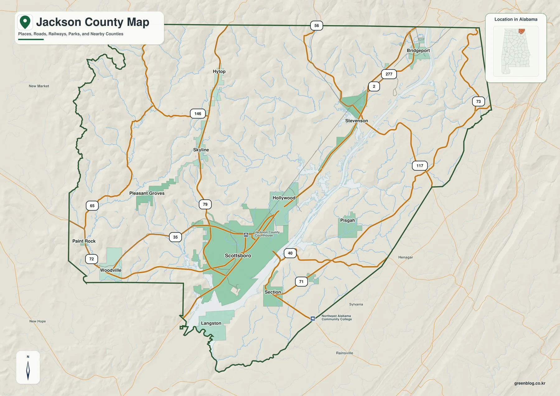
Jackson County occupies the northeastern corner of Alabama. Tennessee lies along the north side, Georgia is close to the northeastern edge, Madison County is to the west, and Marshall and DeKalb counties frame much of the south and southeast. That position gives the county more than one outward travel direction: some routes lead toward Huntsville, others toward Chattanooga, and still others climb south toward the higher plateaus of northeastern Alabama.
Scottsboro is the county seat and the clearest starting point on the map. U.S. 72 crosses the Tennessee Valley from west to east, linking the Huntsville side of the county with Stevenson and Bridgeport. Alabama 35 leaves the valley near Scottsboro and climbs south toward Section and DeKalb County, so a short distance on the page can involve a noticeable change in elevation on the road.
| County seat | Scottsboro |
|---|---|
| Main east-west route | U.S. 72 |
| Southward plateau connection | Alabama 35 |
| Major water features | Tennessee River, Guntersville Lake, Paint Rock River |
| Elevation shown on the map | About 176–567 m, mean about 320 m |
| Download package | Four high-resolution A3 JPG maps in one ZIP |
The county map also labels Bridgeport, Dutton, Hollywood, Hytop, Langston, Paint Rock, Pisgah, Pleasant Groves, Section, Skyline, Stevenson, and Woodville. These places make more sense when grouped by landscape. The northeastern towns follow the long river valley, southern communities rise onto the plateau, and several western settlements sit near lower tributary valleys.
Six places make the county’s settlement pattern easier to see
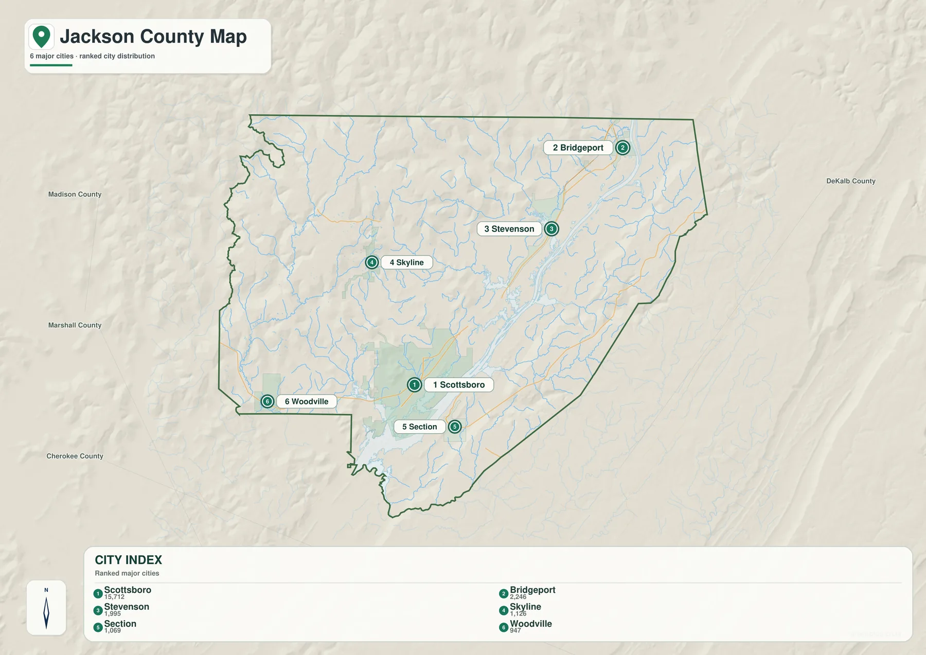
Scottsboro stands apart as the principal urban and administrative center. Bridgeport and Stevenson form a second concentration in the northeast, where the Tennessee River valley points toward Chattanooga and the state borders are nearby. Their location gives them a different orientation from communities farther west or south even though all of them belong to Jackson County.
Skyline provides a useful reference for the higher northern terrain, while Section marks the plateau south of Scottsboro. Woodville sits toward the southwest side of the county, near the lower country approaching the river and its tributaries. The city map therefore works best as a location guide rather than a measure of driving time, because the terrain between the dots matters.
A route that looks direct on a flat map may have to follow a valley, cross a river at a limited point, or climb to a ridge. Scottsboro and Section are a good example: Alabama 35 connects them, but the road rises sharply from the Tennessee Valley. Bridgeport and Stevenson, by contrast, share the long northeastern valley and are connected by routes that stay closer to lower ground.
The Tennessee River widens into Guntersville Lake
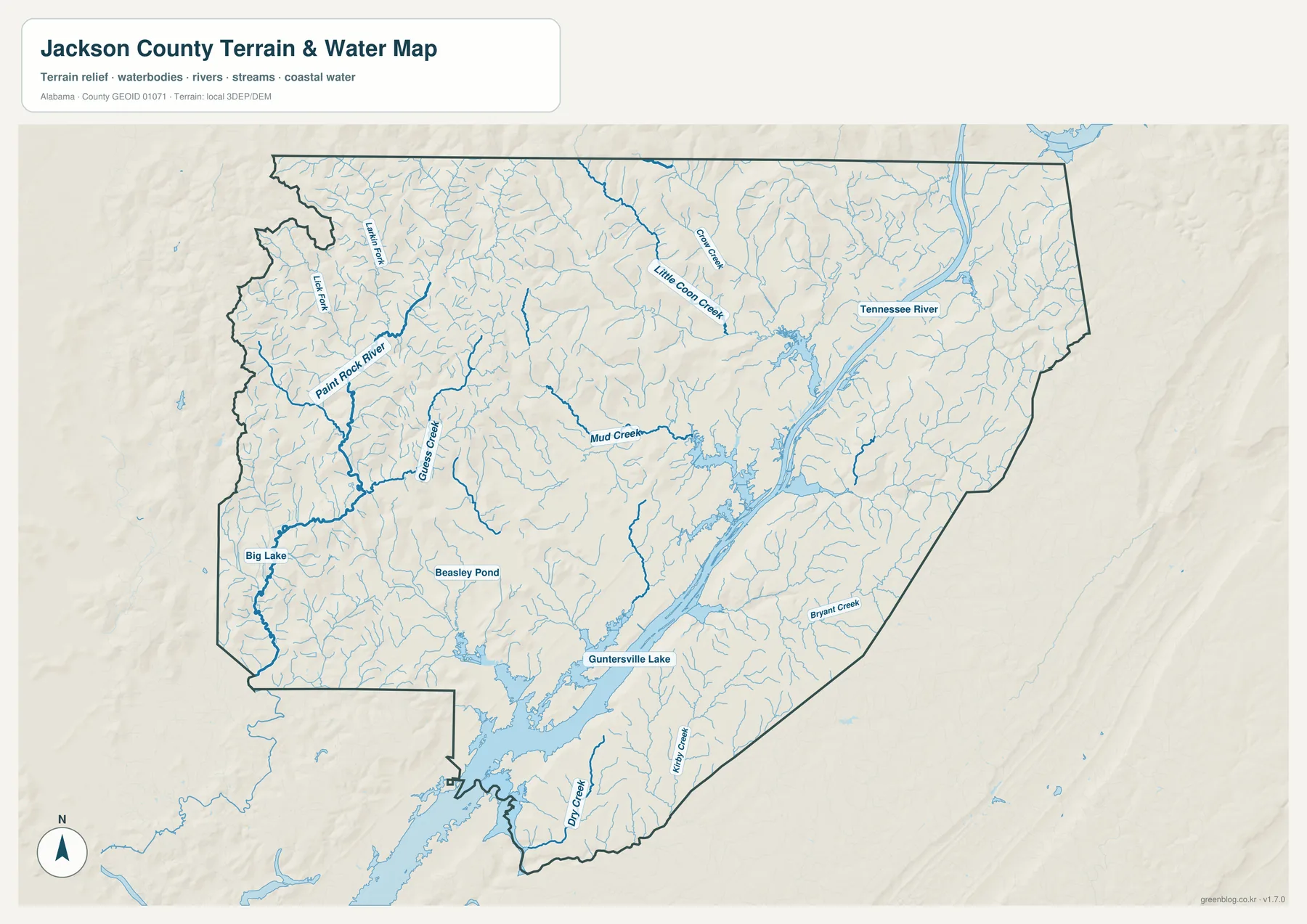
The Tennessee River is the dominant water feature in Jackson County. It enters the northeastern valley, passes through the central part of the county, and opens into the wide arms of Guntersville Lake south of Scottsboro. On the map, the river and lake should be read as parts of one connected system rather than as unrelated bodies of water.
Paint Rock River is the most prominent western tributary shown. Smaller labeled streams include Guess Creek, Mud Creek, Little Coon Creek, Bryant Creek, Kirby Creek, and Dry Creek. Big Lake and Beasley Pond add smaller water bodies to the picture. Together, these features show a dense network of short mountain streams feeding the broader Tennessee River corridor.
Water also helps explain the road map. Guntersville Lake has long, irregular coves, and the main river can only be crossed at selected locations. Roads therefore bend toward bridges and valley passages instead of forming a simple grid. Around Scottsboro and Langston, the shoreline is especially intricate, making the relationship between land, water, and access easy to see in the preview.
The western side tells a different story. Paint Rock River and its tributaries spread across lower valleys before reaching the Tennessee River, while the ridges rise quickly nearby. Looking at the water map before the elevation map makes those transitions much easier to recognize.
A 176–567 meter county is far from flat
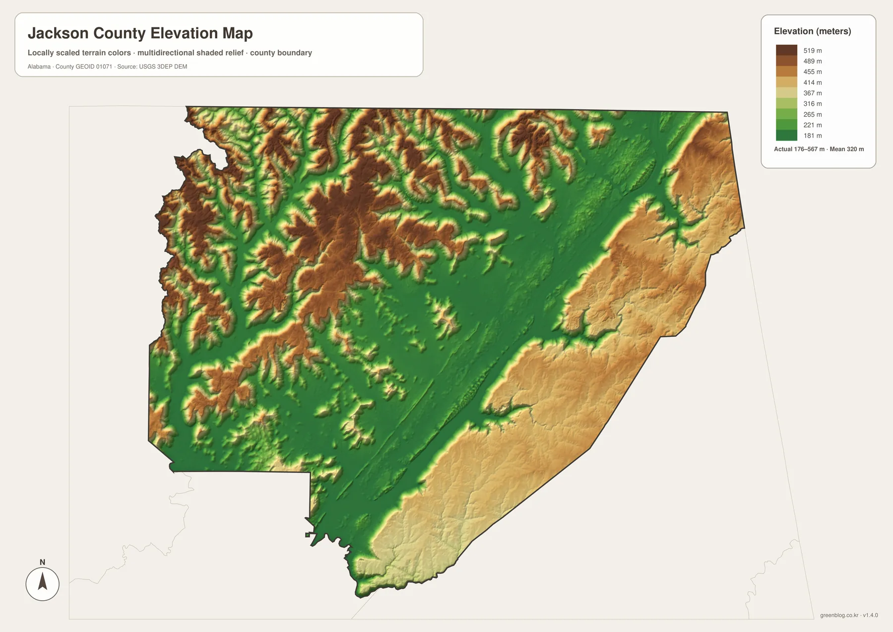
The elevation map gives a local range of about 176 to 567 meters and a mean elevation of about 320 meters. The Tennessee River valley appears as a broad low corridor through the middle of the county. Higher ridges are especially obvious across the northwest, while elevated plateau terrain also occupies much of the east and southeast.
This relief explains several road and settlement choices that are less obvious on the general map. Scottsboro occupies lower ground near the river, but Section lies above the valley on the southern plateau. The climb between them is one reason straight-line distance does not tell the full story of local travel.
Skyline and Hytop mark higher northern country, and the ridged terrain west of the main river corridor contains numerous narrow drainage lines. Stevenson and Bridgeport sit closer to the northeastern valley, where lower ground continues toward the Tennessee border. The county’s towns are therefore distributed around both elevation and water, not simply around one road network.
For map study, switch back and forth between the elevation and water views. The low green valley aligns with the main river, while many creeks cut down from the higher slopes. Roads frequently follow those easier passages before turning toward a ridge crossing or a bridge.
Borders and ridges create several distinct travel directions
The northeastern part of Jackson County naturally points beyond Alabama. Bridgeport and Stevenson are close to the Tennessee and Georgia sides of the county and sit in a valley that continues toward Chattanooga. Scottsboro, meanwhile, functions as the county seat and as the place where east-west valley travel meets routes climbing toward the southern plateau.
Russell Cave National Monument, west of Bridgeport, adds useful context to this landscape. The material included with the package describes a limestone shelter, a spring, and a long record of human use. Its location illustrates why reliable water and accessible valley ground have mattered in a county where rugged ridges can make short distances difficult.
On the west side, the Paint Rock River lowlands lead toward Madison County. To the south, Guntersville Lake and the plateau edge shape routes toward Marshall County. DeKalb County lies beyond the higher southeastern terrain. Reading these directions together shows why Jackson County cannot be summarized by Scottsboro alone: the county seat is central, but the landscape pulls different communities toward different neighboring regions.
Choose the map that fits the question
The general county map is the quickest choice for boundaries, named places, and major roads. The city map is better when you want to compare Scottsboro with Bridgeport, Stevenson, Skyline, Section, and Woodville. Use the water map for the Tennessee River, Guntersville Lake, Paint Rock River, and tributaries, then add the elevation map when the route or community location only makes sense after you see the ridges.
- Use the county map for boundaries, road orientation, and a broad view of named communities.
- Use the city map to compare the main populated places without losing the terrain backdrop.
- Use the water map to trace the Tennessee River system and the creeks entering it.
- Use the elevation map to understand why valley routes and plateau routes feel so different.
For classroom work, the four files can be printed separately and compared side by side. For trip planning or local research, start with the general map and add the water or elevation layer that explains the route you are studying. The A3 format also gives enough room for road labels and smaller place names to remain readable when printed.
Frequently Asked Questions
Are Guntersville Lake and the Tennessee River separate water systems in Jackson County?
No. Guntersville Lake is the broad reservoir reach of the Tennessee River, so the water around Scottsboro and Langston belongs to the same connected river system. The water map is especially helpful because it shows the river narrowing and widening across the county.
Why can Scottsboro and Section feel farther apart than they look on the map?
Scottsboro is close to the low Tennessee River valley, while Section sits on much higher ground to the south. Alabama 35 connects them, but the route must climb the plateau edge. Elevation therefore changes the driving experience even when the horizontal distance is modest.
What is included in the downloadable ZIP?
The archive contains four high-resolution A3 JPG files. They cover the general county map, major-city distribution, terrain and water, and elevation, so you can print one map or compare all four depending on the task.
Map File Information
Download Jackson County Map Files
- Included Files: General county, city, water, and elevation maps
- File Type: Four high-resolution A3 JPG files bundled in one ZIP archive
- Intended Use: Printing, education, presentations, and map-based projects
Related Maps
- Abbeville, Headland, and Lake Eufaula on the Henry County Alabama Map
- Autauga County Map
- Barbour County Alabama Map
Sources and reference data
These official resources provide additional background for county boundaries, roads, waterways, elevation, and the northeastern Jackson County landscape.
- U.S. Census Bureau TIGER/Line Shapefiles — boundary and geographic reference data.
- ALDOT Highway Functional Classification Maps — official road-network reference for Alabama counties.
- USGS National Hydrography — river, stream, and water-feature reference data.
- USGS 3D Elevation Program — elevation data used to understand local relief.
- National Park Service: Russell Cave National Monument — natural and cultural context for the northeastern part of the county.
Green Map creates custom-edited map images using open geographic data sources such as geoBoundaries, Natural Earth, OpenStreetMap, and government open data. These maps are edited visual materials, not raw data files, and are provided for education, documents, presentations, and graphic reference.