Download the Jefferson County Alabama map set on this page as one ZIP containing four high-resolution A3 JPG maps. The files cover the county boundary and roads, major cities around Birmingham, waterways led by the Cahaba River, and local elevation, making them useful for printing, class materials, trip planning, or personal reference. Red Mountain separates central Birmingham from much of the southern suburban belt, while long valleys and higher eastern ridges shape the county beyond the city center.
The map set moves from broad county orientation to more focused detail without reducing Jefferson County to a single city dot. The county view keeps boundaries and major roads visible, the city view highlights six major places, and the water and elevation maps show how the Cahaba River, smaller creeks, valleys, and higher ground fit around the metropolitan area.
The combination matters here because settlement and terrain are closely connected. Birmingham, Bessemer, Hoover, Vestavia Hills, Homewood, and Trussville occupy different parts of the county, while I-65, I-20, I-59, I-459, and other major routes follow or cross the same valleys and ridges shown on the terrain maps. Looking at the maps together makes the metro area’s shape much easier to follow.
Table of Contents
Birmingham at the Center of a Ridge-and-Valley County
Jefferson County sits in north-central Alabama and borders Blount, St. Clair, Shelby, Bibb, Tuscaloosa, and Walker counties. Birmingham occupies the central part of the county and serves as the main point of orientation. Gardendale and Fultondale lie to the north, Trussville and Irondale are to the east, Leeds sits near the eastern edge, and Mountain Brook, Vestavia Hills, and Hoover form a closely spaced group south and southeast of Birmingham. Hueytown and Bessemer anchor the southwest, while Adamsville and Graysville help define the western side.
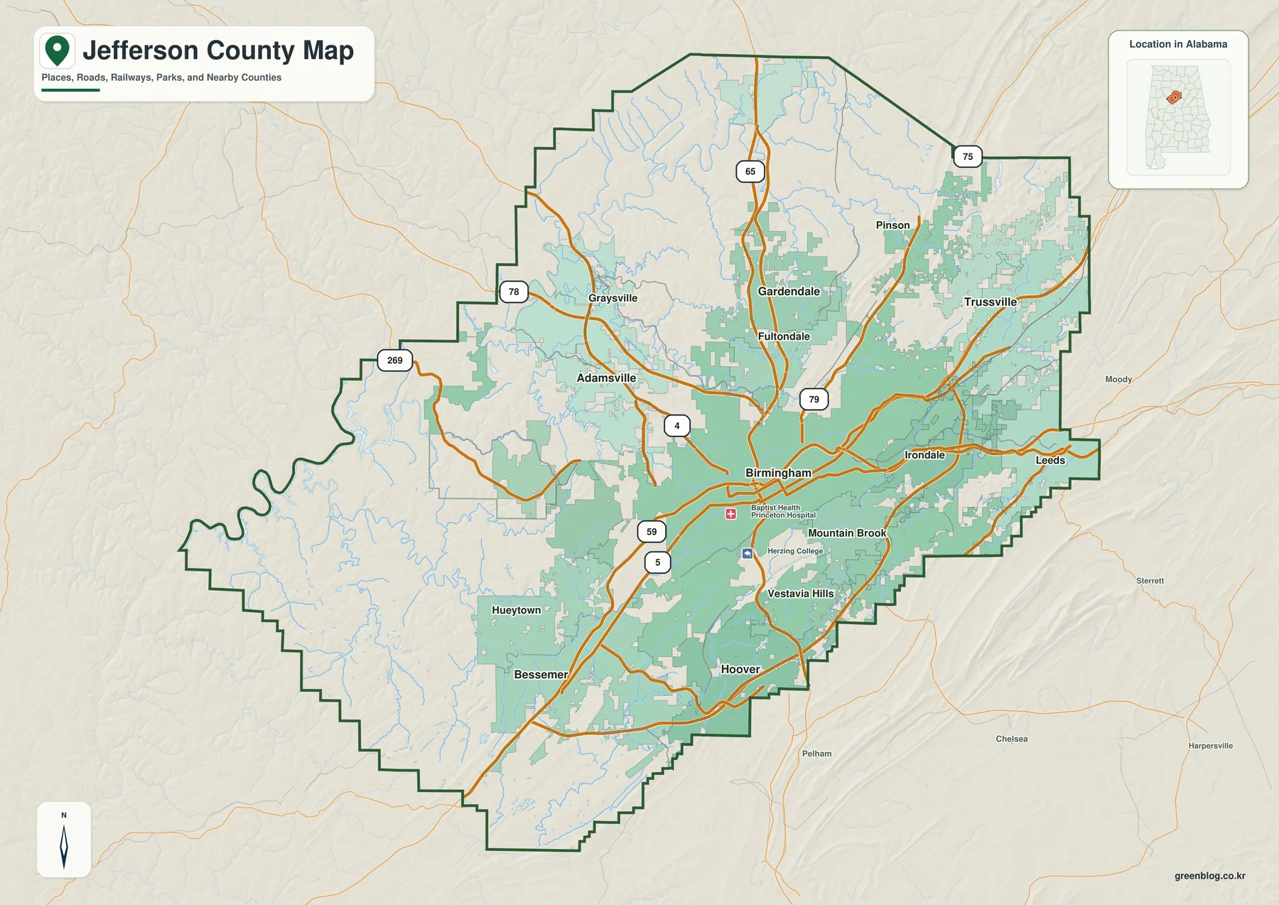
The road network gives the map a second layer of structure. I-65 runs north to south through the Birmingham area and continues toward Homewood and Hoover. I-20 and I-59 provide the major eastward and northeastward connections, while I-459 curves around the southern and eastern suburbs instead of passing through downtown. I-22 heads northwest, and U.S. 31 and U.S. 280 are especially useful for locating the southern suburban belt.
The Census figures supplied with this county package list a July 1, 2025 population estimate of 665,742 and a 2020 census count of 674,721. Those totals show the scale of the county, but the map tells a more useful geographic story: dense urban development occupies only part of the county. Large stretches to the west and northwest remain much less built up, and even within the metropolitan core, ridges and valleys break the urban area into separate corridors.
That contrast is one reason a countywide map is more useful than a Birmingham street map for regional orientation. It shows how quickly the built-up area changes as you move toward the western boundary, how the eastern suburbs approach St. Clair County, and how Hoover and the southern side of the metro sit close to Shelby County. The county boundary keeps those relationships clear without losing the major local place names.
Six Major Cities Show the Metro’s Uneven Shape
The city map simplifies the county by highlighting six major cities and ranking them with the values printed on the map. Birmingham is shown at 198,173, followed by Hoover at 92,642, Vestavia Hills at 38,616, Homewood at 27,829, Trussville at 26,673, and Bessemer at 25,400. The point of this view is not to replace a full municipal map; it is to make the relative position of the largest labeled cities easy to compare at a glance.
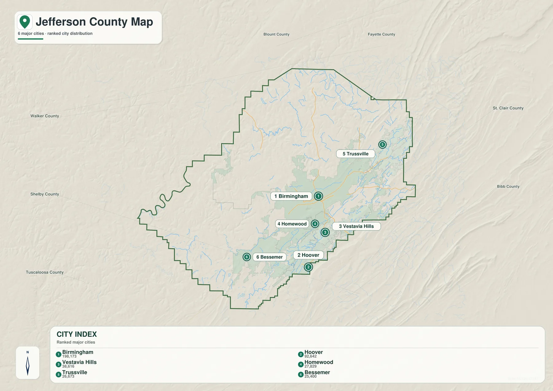
The south side of the map is especially revealing. Homewood sits immediately south of Birmingham, Vestavia Hills is farther southeast, and Hoover extends still farther south toward the Shelby County side of the metro. They appear close together, but Red Mountain and other ridges limit where roads can cross. That helps explain why short straight-line distances do not always produce a simple street pattern.
Trussville creates a different center of gravity in the northeast. It is tied to Birmingham by the eastern interstate corridors but is visibly separated from the southern suburban group. Bessemer, meanwhile, occupies the southwest and has an administrative importance that its population rank alone does not show. Jefferson County operates Birmingham and Bessemer divisions for parts of its court and administrative system, making Bessemer a genuine regional reference point rather than just another suburb.
When more detail is needed, the county map adds places such as Gardendale, Fultondale, Pinson, Irondale, Leeds, Mountain Brook, Hueytown, Adamsville, and Graysville. Switching between the two views is useful: the city map establishes the broad metropolitan layout, while the county map fills in the communities and roads between the major city labels.
Interstates Connect Corridors, Not a Simple Grid
Jefferson County’s highway map makes more sense when the terrain is kept in mind. Birmingham developed in Jones Valley, with Red Mountain immediately to the south and another broad valley beyond it. These features run generally southwest to northeast, so many roads either follow the lower ground or concentrate at a limited number of ridge crossings. The result is a metropolitan road network built around corridors rather than a uniform grid.
I-65 is the clearest north-south route. It enters the northern urban area near Gardendale and Fultondale, passes Birmingham, and continues toward Homewood and Hoover. I-20 and I-59 provide the major east and northeast connections, linking the Birmingham area with Leeds and Trussville directions. I-459 works as an outer connection around the southern and eastern suburbs, meeting other major highways without requiring every trip to cross downtown.
U.S. 280 is particularly important southeast of Birmingham, where the road serves the Mountain Brook, Vestavia Hills, and broader suburban side of the metro before continuing toward Shelby County. U.S. 31 offers another north-south reference through the southern suburbs. On the northwest side, I-22 leads toward Walker County and beyond. These routes are easier to remember when they are tied to specific parts of the county rather than treated as a list of highway numbers.
The county boundary also helps with regional travel. The Leeds side of Jefferson County is close to St. Clair County, the Hoover side approaches Shelby County, and western routes lead toward Walker and Tuscaloosa counties. A traveler or student using the map can therefore see not only where a city sits inside Jefferson County, but also which neighboring county lies beyond the nearest edge.
Cahaba River, Creeks, and Reservoirs Across the County
The water map removes much of the urban detail and gives the county’s rivers and smaller streams room to stand out. Cahaba River is the major labeled river in the southeast. Shades Creek crosses the southern part of the county, Valley Creek appears toward the west and southwest, and Village Creek and Fivemile Creek are prominent through the central and northern drainage areas. Turkey Creek is labeled in the northeast, where the stream network becomes especially dense.
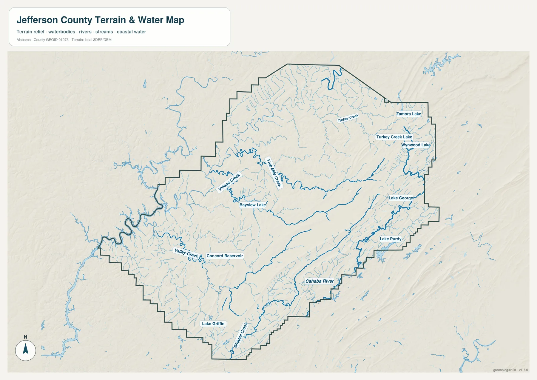
Several smaller water bodies are also named on the map, including Concord Reservoir, Bayview Lake, Lake Griffin, Lake Purdy, Lake George, Turkey Creek Lake, Wynwood Lake, and Zamora Lake. These labels are useful when a general road map feels too crowded or when the goal is to locate a reservoir, creek crossing, or watershed feature rather than a city.
The Cahaba is an important natural resource in the Birmingham region, and local river information emphasizes its ecological and drinking-water value. The map here is designed to show location and terrain, however, not flood risk, water quality, legal access, or property ownership. For those questions, current agency or local authority information should be used alongside the map.
Water and transportation often occupy the same valleys, so the water map also helps explain the road map. Valley Creek and Village Creek run through areas that have long carried rail, industry, neighborhoods, and major routes. In the southeast, the Cahaba and its tributaries occupy lower ground between ridges. Comparing these waterways with the elevation map shows why some parts of the county feel open and connected while others are divided by narrow, higher land.
Elevation Changes Behind the Street Pattern
The elevation map gives Jefferson County a very different appearance from a normal political map. The map reports an actual elevation range of about 26 to 428 meters, with a mean of 177 meters. Color indicates relative height, while shaded relief makes individual ridges, side valleys, and stream-cut slopes easier to see.
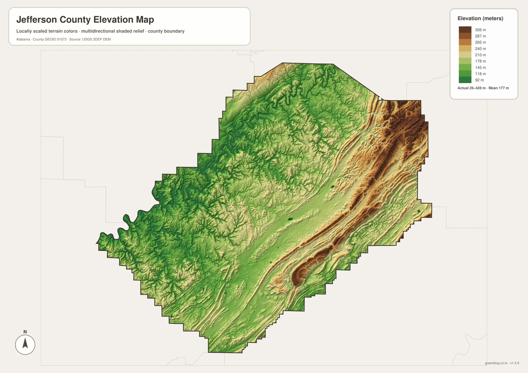
The highest-looking terrain is concentrated along the eastern and southeastern ridge country, where several long bands run nearly parallel to one another. Central Jefferson County contains broader lower valleys, and the western side mixes rolling terrain with a branching network of stream valleys. The visual contrast is strong enough that the county’s transportation layout begins to make sense even without road labels.
Red Mountain is the best-known local example of this relationship. Downtown Birmingham lies north of the ridge, while Homewood, Mountain Brook, Vestavia Hills, and Hoover occupy areas across or beyond it. Major roads such as U.S. 31, U.S. 280, and I-65 use specific crossings through this terrain. The map therefore helps explain why nearby communities can be separated by a distinct topographic barrier.
The elevation view is most useful when a reader wants more than an address or boundary. It can support a classroom discussion of Alabama’s Ridge and Valley landscape, help a visitor understand why a route bends around higher ground, or provide a clearer background for the county’s rivers and streams. For exact survey elevations, site engineering, or hazard decisions, more specialized data would still be required.
Industry Grew Where Rail, Minerals, and Valleys Met
Birmingham’s industrial history is closely tied to the same landscape visible on the maps. Historical material from Sloss Furnaces describes iron ore along Red Mountain, coal to the north and west, and limestone and related materials in the valley area. Rail connections added transportation to that unusual concentration of resources, helping Birmingham grow rapidly after its founding in 1871.
That history left a geographic imprint even as the modern economy diversified. Older industrial communities, rail corridors, and transportation routes stretch through Jones Valley and toward the southwest. Bessemer developed as a major industrial center in that same broader region. Seeing Birmingham and Bessemer on the city map, then comparing the ridge and valley pattern on the elevation map, makes that historic relationship more concrete.
The county’s present-day administrative arrangement also preserves the importance of the southwest. Jefferson County maintains court functions in both Birmingham and Bessemer, with separate divisions used for parts of the system. That fact is useful for map readers because it explains why the southwest is not simply an outer residential extension of Birmingham; it has long had its own civic and industrial identity.
At the same time, the southern suburbs developed in a different setting. Homewood, Mountain Brook, Vestavia Hills, and Hoover spread across and beyond the ridge system rather than along the older industrial valley alone. The modern county therefore contains several overlapping landscapes: the historic industrial core, newer suburban corridors, lower-density western areas, and water-rich eastern and southern valleys.
Choosing the Right Jefferson County Map
The best file depends on what you need to find. For a broad overview, start with the county map because it combines the boundary, major roads, streams, and many place labels. If the goal is to compare the location of Birmingham with the largest suburban cities, the city map is cleaner. The water map is better for the Cahaba River, named creeks, lakes, and reservoirs, while the elevation map is the strongest choice for ridges, valleys, and changes in height.
- County map: best for boundaries, road orientation, and a wider set of labeled communities.
- City map: best for comparing Birmingham, Hoover, Vestavia Hills, Homewood, Trussville, and Bessemer.
- Water map: best for Cahaba River, local creeks, reservoirs, and drainage features.
- Elevation map: best for seeing the ridge-and-valley terrain that shapes roads and settlement.
The WebP images on the page are convenient previews, but the downloadable archive contains the original high-resolution JPG versions. All four files use an A3-oriented layout, making them more suitable for printing or close inspection than a browser preview. You can keep the full set together or use only the map that fits a specific project.
For print use, open the JPG you want first and check paper orientation and margins before sending it to the printer. Keeping the image close to its original proportions preserves small labels and stream detail. For presentations or digital documents, the maps can also be cropped to emphasize a specific part of the county without changing the original file.
Frequently Asked Questions
Why are both Birmingham and Bessemer important when reading a Jefferson County map?
Birmingham is the county seat and the largest urban center, while Bessemer serves as an important administrative center for the southwest. Jefferson County uses Birmingham and Bessemer divisions for parts of its judicial and administrative system, so the two cities work well as separate reference points when dividing the county into regions.
Why do the southern suburbs look close together but have complicated road connections?
Red Mountain and other parallel ridges cross the Birmingham area from southwest to northeast. Homewood, Mountain Brook, Vestavia Hills, and Hoover are geographically close, but traffic has to use a limited number of major crossings and valley routes, including U.S. 31, U.S. 280, I-65, and I-459.
What do the water and elevation maps add that the county map does not?
The water map separates Cahaba River, creeks, lakes, and reservoirs from the busier road network, while the elevation map shows the higher ridges and lower valleys around them. Used together, they explain why streams follow certain corridors and why roads and communities are concentrated in some valleys rather than spread evenly across the county.
Map File Information
Jefferson County A3 Map Files
- Included Files: County boundary-and-road map, major-city map, water map, and elevation map
- File Type: Four high-resolution A3 JPG files in one ZIP archive
- Intended Use: Printing, education, presentations, and map-based projects
Related Maps
- Abbeville, Headland, and Lake Eufaula on the Henry County Alabama Map
- Autauga County Map
- Barbour County Alabama Map
Sources and Reference Data
The geographic and local context on this page is based on the supplied map package and the following government or institutional references. For information that changes over time, such as population or road classification, use the linked source for the latest available update.
- U.S. Census Bureau QuickFacts – Jefferson County, Alabama
- Jefferson County Commission official overview
- Alabama Department of Transportation Highway Functional Classification Maps
- USGS – Water availability in Jefferson County, Alabama
- City of Birmingham – Sloss Furnaces history
- USGS 3D Elevation Program
Green Map creates custom-edited map images using open geographic data sources such as geoBoundaries, Natural Earth, OpenStreetMap, and government open data. These maps are edited visual materials, not raw data files, and are provided for education, documents, presentations, and graphic reference.