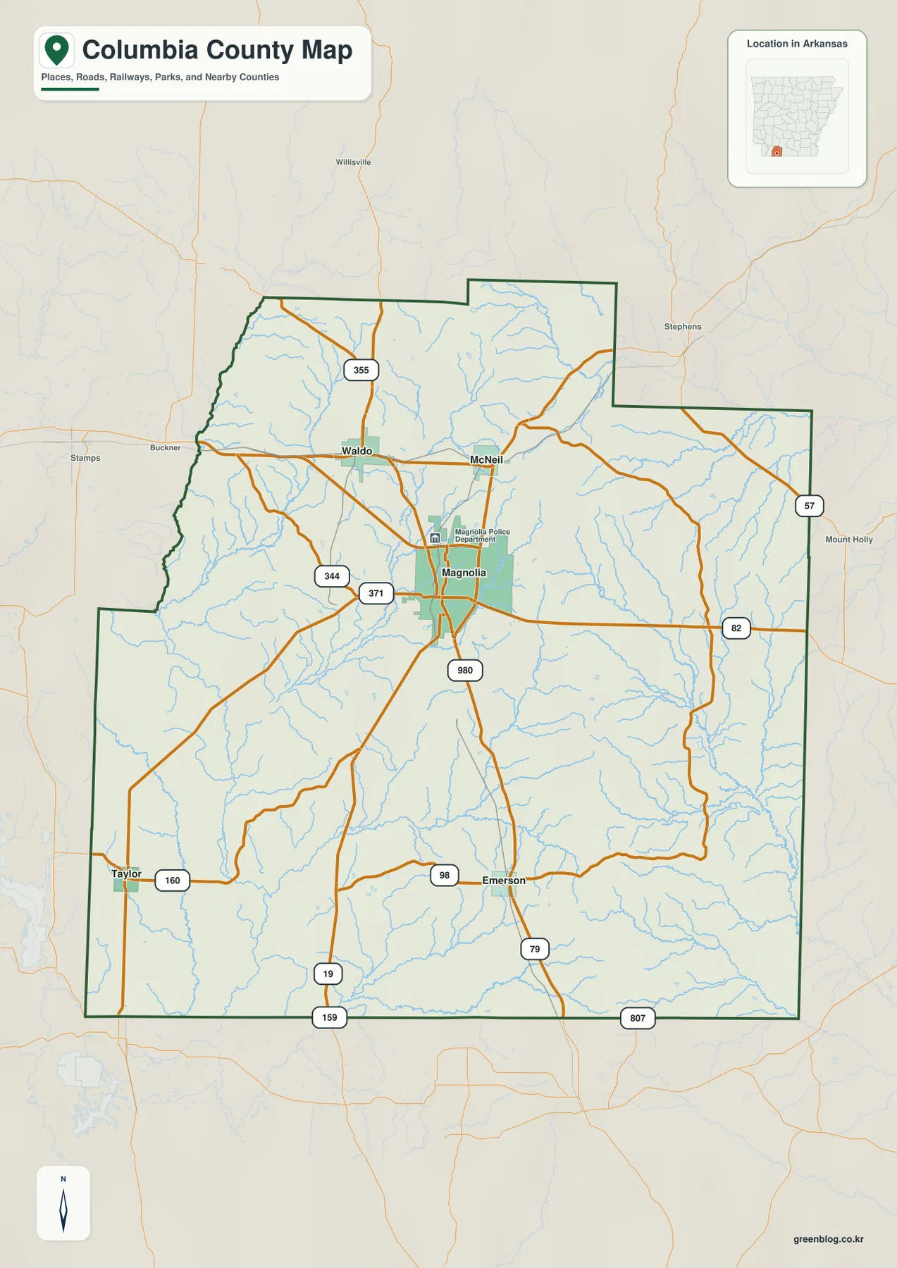
This Columbia County Arkansas Map page provides four high-resolution JPG originals in a downloadable ZIP, along with web previews for roads, towns, waterways, and elevation. Magnolia is the clearest place to begin. Waldo lies to the northwest, McNeil to the north, Emerson to the south, and Taylor near the southwestern side of the county. The map set also shows a dense network of creeks crossing low valleys between rolling uplands, with elevations ranging from about 45 to 132 meters. The sections below focus on those visible county-specific features rather than treating the maps as interchangeable layers.
Columbia County does not have a tight chain of large towns. Magnolia stands out as the central settlement and county seat, while the other named towns are spread widely in different directions. The Association of Arkansas Counties and the Encyclopedia of Arkansas both identify Magnolia as the county seat, and the road map reflects that importance by showing several major routes meeting or passing close to the city. The surrounding county, however, remains much more rural and broken by small streams and low ridges.
The terrain is best described as rolling rather than mountainous. The supplied elevation map reports an actual low near 45 meters, a high near 132 meters, and a mean around 83 meters. Higher tan and brown ridges are most obvious across the northern and central parts of the county, while broader green lowlands appear toward the south and east. Creeks such as Beech Creek, Big Creek, Horsehead Creek, Big Cornie Creek, and Hurricane Creek follow lower corridors between these ridges, which makes the water and elevation maps especially useful when viewed together.
Table of Contents
Magnolia is the easiest anchor for roads reaching every part of the county
On the general county map, Magnolia sits slightly north of the center and has the strongest concentration of road lines. Route 82 crosses the county east and west through the Magnolia area. North of the city, McNeil and Waldo provide the next two major reference points, with Route 355 continuing north of Waldo. Route 980 is labeled south of Magnolia, while Route 371 and Route 344 are visible to the west and northwest. These numbered routes make more sense when read as links between recognizable towns rather than as a list to memorize.
Emerson lies well south of Magnolia near Route 98, and Route 79 continues through the southern part of the county. Taylor is farther southwest near Route 160. Routes 19, 159, and 807 appear close to the southern boundary, showing how the road network spreads across a relatively wide rural area. The southern half contains fewer prominent town labels than the Magnolia area, so the road map becomes especially useful for maintaining a sense of direction between Emerson, Taylor, and the county boundary.
East of Magnolia, Route 82 continues across a long open section before reaching the eastern side of the county. Route 57 is marked near the eastern boundary. The county outline is also distinctive here: the northeastern section steps inward and outward rather than forming one straight rectangle. Nearby labels such as Stephens and Mount Holly sit outside the county and help establish how Columbia County fits against its neighbors.
The general map also shows a highlighted urban area around Magnolia and a local police-department marker, but the page is intended for county orientation rather than facility navigation. Current turn-by-turn directions, construction notices, or road closures should be checked with a live navigation service. For map reading, the most useful first step is simply to place Magnolia, Waldo, McNeil, Emerson, and Taylor in the correct parts of the county.
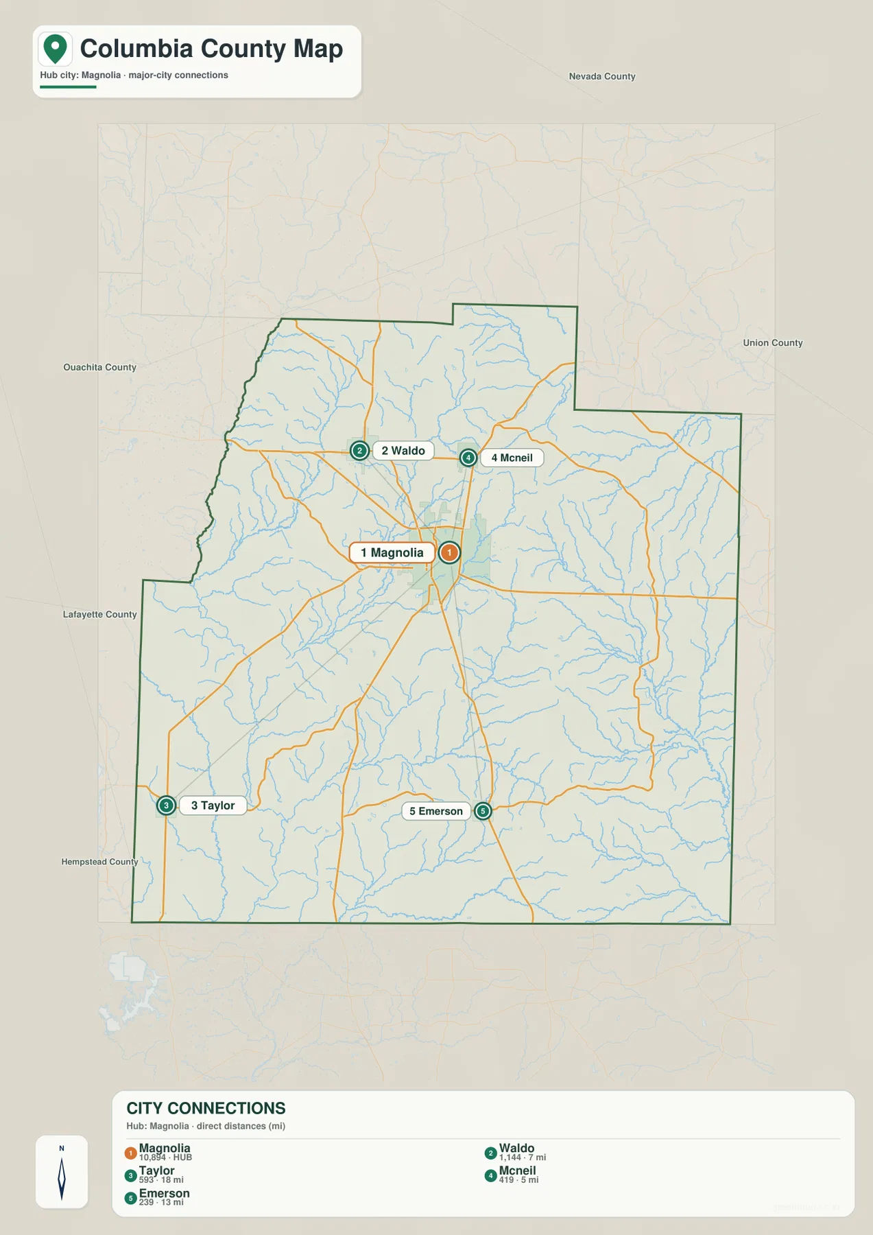
The city-connections map shows how widely the main towns are spaced around Magnolia
The city map uses Magnolia as the hub and connects it to Waldo, McNeil, Emerson, and Taylor. The distances printed on this map are direct straight-line distances, not road mileage. McNeil is shown about 5 miles from Magnolia, Waldo about 7 miles, Emerson about 13 miles, and Taylor about 18 miles. Those values are useful for comparing relative spacing, but actual driving routes can be longer because roads do not follow perfectly straight lines.
Waldo and McNeil form a northern pair, but they are not in the same direction. Waldo lies northwest of Magnolia, while McNeil is almost directly north. Emerson is positioned farther south and Taylor occupies the southwestern edge of the main city set. This distribution makes the county easier to remember as a central hub with separate northern, southern, and southwestern branches rather than as a single north-south corridor.
Magnolia’s role on the map matches its official status as the county seat. The city is also the largest and most visually prominent settlement on the supplied map set. Once Magnolia is located, the four connector lines provide a clean way to add the surrounding towns without the distraction of minor roads or dozens of stream lines. This is particularly useful for classroom slides or a quick county overview where city position matters more than route detail.
Names of neighboring counties are printed outside the boundary, including Nevada, Ouachita, Lafayette, Hempstead, and Union counties. These labels help place Columbia County in southwestern Arkansas. They also explain why Taylor is near the southwestern edge while the eastern side opens toward Union County. Again, the city-map distances are straight-line values only and should not be interpreted as travel time or driving mileage.
Creek valleys divide the rolling landscape from Beech Creek in the northwest to Cornie Creek in the east
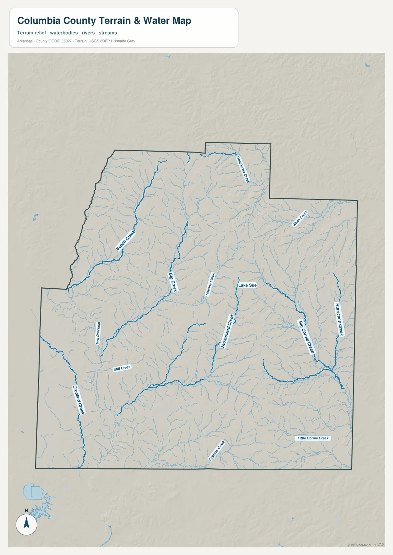
The hydrography map gives the county a very different appearance from the road map. In the northwest, Beech Creek is one of the strongest channels and curves toward the southwestern side of the upper county. Big Creek runs farther east and drains through the north-central area. Numerous smaller tributaries join both channels, revealing a dense branching drainage network that is easy to overlook when roads and town labels dominate the view.
Near the northeastern projection, Smackover Creek is labeled as another distinct waterway. Sloan Creek appears farther east, while Williams Creek occupies the central part of the map. Lake Sue sits near Horsehead Creek, which extends southward through a long valley. These features give useful local reference points between Magnolia’s central area and the eastern half of the county, even though the water map itself does not emphasize towns.
The eastern side is defined by Big Cornie Creek and Hurricane Creek, both of which run through broad drainage corridors. Little Cornie Creek appears farther south. Big Cornie Creek bends toward the southeast and is joined by many smaller tributaries, while Hurricane Creek follows the eastern side before reaching the same general lower drainage area. When the water layer is compared with the elevation map, these channels consistently line up with green lowlands between higher ridges.
Western and southern waterways add another pattern. Bayou Dorcheat is labeled along the western side, Crooked Creek extends through the southwest, and Mill Creek and Cypress Creek appear farther south. The Encyclopedia of Arkansas notes Dorcheat Bayou drainage on the west and Cornie Creek drainage on the east, which agrees with the broad division visible in the supplied hydrography image. Rather than one dominant river cutting across the entire county, Columbia County contains several creek systems working through separate valleys.
This water map is a geographic reference, not a flood, navigation, parcel, or legal-boundary product. A blue line shows the mapped position of a stream or creek, but it does not indicate current depth, flood probability, boat access, or ownership of adjoining land. For safety or engineering decisions, current agency data should be used instead. Here, the useful question is where the named waterways sit in relation to the county’s broader terrain.
Elevation rises across the north and central ridges before dropping into southern and eastern valleys
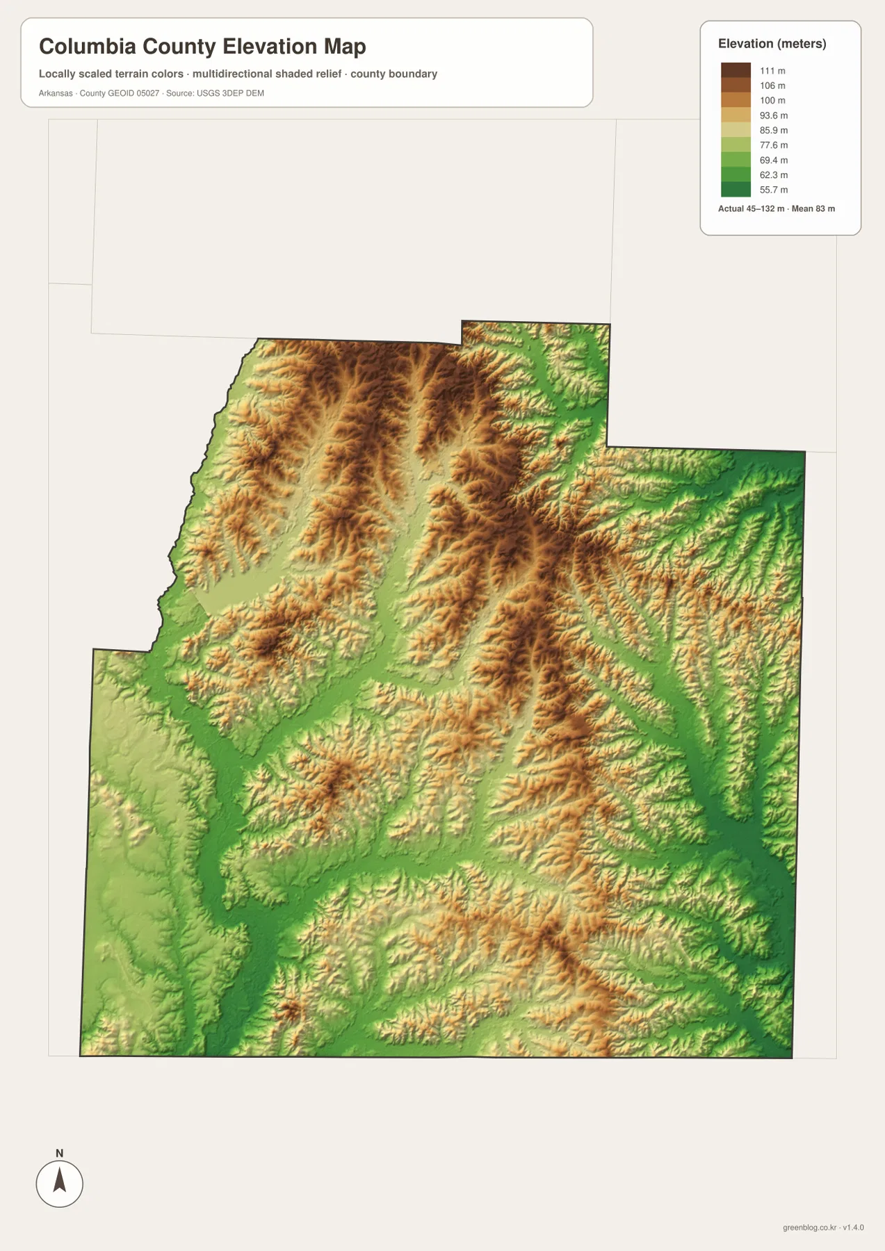
The elevation layer reports an actual county range of about 45 to 132 meters, with an average near 83 meters. Brown and dark tan ridges are concentrated across the northwest, north-central, and central-eastern portions. Long green corridors cut between those ridges, often matching the major creeks shown on the water map. This gives the county a noticeably textured surface even though none of the elevations approach mountain heights.
Toward the south, green terrain becomes more extensive and the high ridges are less continuous. The Taylor area in the southwest and the land south of Emerson contain broader low zones with smaller ridges scattered between drainage corridors. The eastern edge also has a long lower strip that corresponds well with the Big Cornie Creek and Hurricane Creek side of the hydrography map.
The Magnolia area sits between several of these terrain types. Higher ridges are more common toward Waldo and McNeil to the north, while lower terrain becomes broader toward Emerson in the south. Moving east from Magnolia also crosses alternating uplands and creek valleys rather than one flat surface. This helps explain why many secondary roads and waterways bend repeatedly across the county.
The elevation image is intended for county-scale comparison. Its 45–132 meter range is useful for identifying broad high and low areas, but it should not be treated as survey-grade measurement for a property, construction project, or drainage design. Detailed USGS 3DEP data or professional field measurements are appropriate when exact point elevation is required.
Magnolia, Waldo, and Emerson provide a simple framework for remembering the county
A practical way to remember Columbia County is to start with three anchors. Magnolia represents the central road and administrative focus, Waldo helps define the northwestern side, and Emerson marks the southern part of the county. McNeil can then be added just north of Magnolia, while Taylor provides the southwestern edge. This sequence is easier to retain than a long list of secondary roads or creek names.
The terrain changes in useful ways around those same anchors. North of Magnolia toward Waldo and McNeil, the elevation map contains more frequent higher ridges and the water map shows channels such as Big Creek and Beech Creek. South toward Emerson and Taylor, lower green terrain becomes broader and small tributaries spread across a wider area. East of Magnolia, Big Cornie Creek and Hurricane Creek give the eastern lowlands a separate identity.
The straight-line city distances reinforce that pattern. McNeil and Waldo are only about 5 to 7 miles from Magnolia on the connector map, while Emerson is about 13 miles away and Taylor roughly 18 miles. Those numbers do not replace driving mileage, but they quickly show that the southern and southwestern towns are farther from the central hub than the two northern towns.
Choose the layer that matches the question instead of forcing every detail into one map
Use the general county map when you need boundaries, town names, and major route numbers together. The city-connections map is cleaner when the goal is simply to compare Magnolia with Waldo, McNeil, Emerson, and Taylor. For Beech Creek, Big Creek, Bayou Dorcheat, Horsehead Creek, Big Cornie Creek, and the other waterways, the hydrography map is the better choice. The elevation map is most useful when the question is where the rolling uplands rise above the lower creek valleys.
Two maps can also work well together. Pair the city map with the general map to move from simple town locations to road context, or pair the water map with the elevation layer to see why creeks follow particular valleys. This is especially helpful in teaching or presentation settings because the reader can focus on one kind of information at a time instead of trying to interpret every label in one image.
For printing or close inspection, use the original JPG files rather than enlarging the WebP previews. The ZIP below contains the county, city, water, and elevation maps at 2572 × 3638 pixels each. Road numbers, small creek names, and terrain shading are easier to inspect at full resolution, making the archive useful for lessons, reports, presentations, and personal reference.
Frequently Asked Questions
Are the distances from Magnolia on the city map driving distances?
No. The connector map labels them as direct straight-line distances. McNeil is shown about 5 miles from Magnolia, Waldo about 7 miles, Emerson about 13 miles, and Taylor about 18 miles. Actual road mileage can be longer, so current navigation tools should be used for travel planning.
Which waterways are labeled on the supplied Columbia County water map?
The map labels Beech Creek, Big Creek, Smackover Creek, Sloan Creek, Williams Creek, Horsehead Creek, Big Cornie Creek, Hurricane Creek, Bayou Dorcheat, Crooked Creek, Cypress Creek, and several smaller features. These names help show how separate creek valleys divide the rolling uplands across the county.
Can the 45–132 meter elevation map be used for surveying?
No. It is a generalized county-scale elevation reference for comparing broad ridges and valleys. Property-level construction, engineering, or drainage work requires detailed elevation data or professional surveying rather than values read from this overview map.
Map File Information
The ZIP contains high-resolution JPG originals for the Columbia County general map, city map, water map, and elevation map.
- Included Files: County map, city map, water map, elevation map
- Printable Size: 2572 × 3638 px each
- File Type: JPG
Related Maps
Sources and references
- Association of Arkansas Counties – Columbia County: county overview, Magnolia as the county seat, and regional landscape context.
- Encyclopedia of Arkansas – Columbia County: county geography, history, and background on Dorcheat Bayou and Cornie Creek drainage.
- U.S. Census Bureau TIGER/Line Shapefiles: official reference for county boundaries, roads, and place geography.
- USGS National Hydrography: official reference for rivers, streams, and waterbodies.
- USGS 3D Elevation Program: official elevation and terrain reference.
Green Map creates custom-edited map images using open geographic data sources such as geoBoundaries, Natural Earth, OpenStreetMap, and government open data.
These maps are edited visual materials, not raw data files, and are provided for education, documents, presentations, and graphic reference.