Humphreys County sits in the low, flat Mississippi Delta, where Belzoni provides the clearest reference point for a county filled with small communities, waterways, and long north-south road connections. The map set on this page is most useful when the four views are read together: the county map establishes roads and boundaries, the city map shows how the main towns are spaced, the water map makes the Yazoo River system easier to follow, and the elevation map reveals subtle changes across terrain that otherwise looks almost level. High-resolution JPG versions of the maps are available in the download box below.
Table of Contents
Belzoni as the Main Reference Point
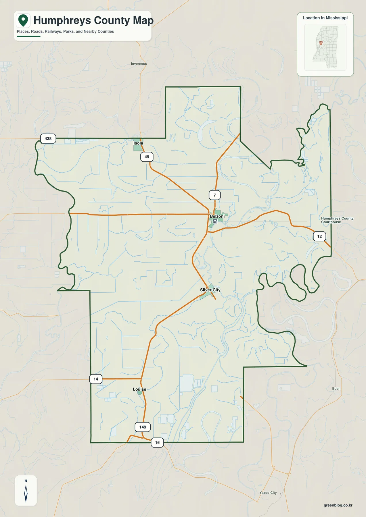
Belzoni appears near the middle of the county and works well as the starting point for understanding the road pattern. Isola is north of it, while Silver City and Louise extend the settlement pattern southward. The county outline is irregular rather than rectangular, especially along the east side and in the narrow northern projection. Those bends matter because a quick glance at a state map can make Humphreys County look simpler than it is.
The road map shows several numbered routes meeting or passing near Belzoni. Route 49 continues north toward Isola, while Routes 7 and 12 help orient the central and eastern parts of the county. Farther south, Routes 149 and 16 appear near the Silver City–Louise side, with Route 14 along the west and Route 438 across the northwest. The result is a road system that stretches along the county’s long shape instead of forming one compact urban grid.
County Facts That Add Context to the Map
- County seat: Belzoni
- Communities labeled on the maps: Belzoni, Isola, Silver City, Louise
- 2020 Census population: 7,785
- July 2025 population estimate: 7,001
- 2025 Gazetteer area: 418.635 square miles of land and 12.599 square miles of water
- Elevation shown on the supplied map: about 24–40 m, mean 32 m
The population and area numbers are useful background, but they describe different things and come from different reference dates. The 2020 Census gives the decennial population count, while the July 2025 figure is a later estimate. The Gazetteer separates land and water area. These figures help establish the scale of the county, but the maps do a better job of showing where communities, roads, rivers, lakes, and low ground actually sit in relation to one another.
How Isola, Silver City, and Louise Relate to Belzoni
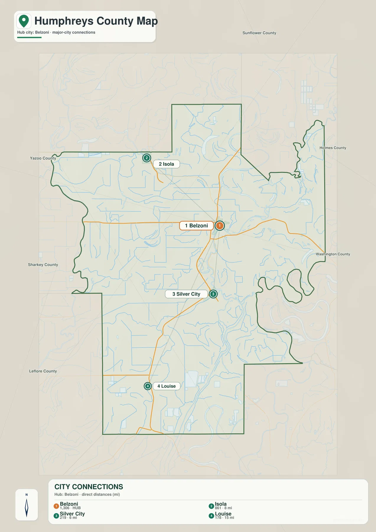
The city-connections map uses Belzoni as its hub. Isola is shown about 8 miles away, Silver City about 6 miles away, and Louise about 15 miles away. These are straight-line distances, not driving distances, so they should be used to understand relative position rather than travel time. A road trip between the same places can be longer because the route must follow the actual road network.
The population labels on the city map also show how small the local settlement pattern is. Belzoni is listed at 1,306 residents, followed by Isola at 861, Silver City at 219, and Louise at 178. Belzoni is therefore the largest of the mapped communities, but the county does not read like a single built-up urban area. Instead, the towns are spaced along different parts of the road network, with broad rural areas between them.
The Yazoo River and a Dense Network of Waterways
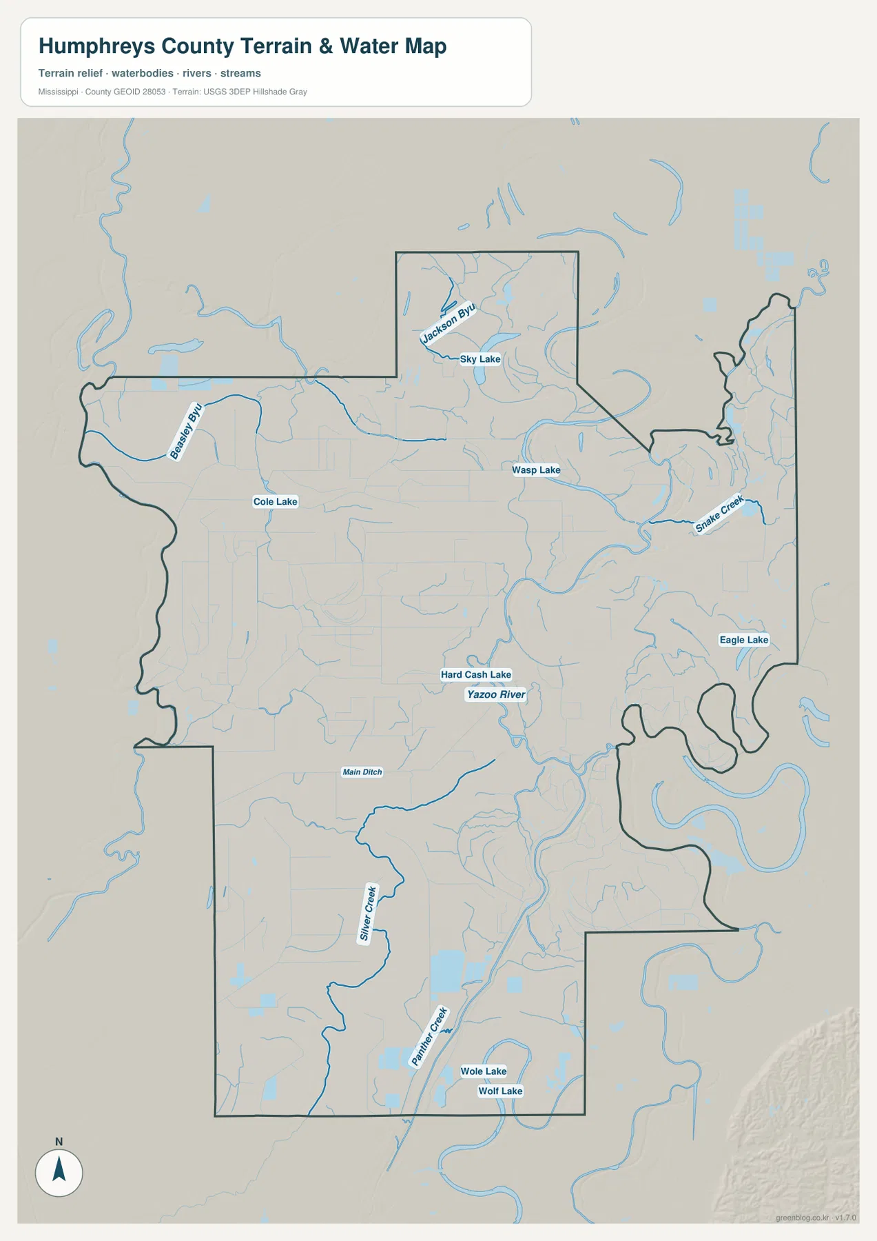
The water map changes the visual emphasis of the county. The Yazoo River is the dominant named river, curving through the central and eastern side of Humphreys County. Around it are many smaller channels that make the landscape look far more water-connected than the road map suggests. Beasley Bayou and Jackson Bayou appear in the north, Snake Creek lies toward the east-central side, and Main Ditch crosses part of the interior. Silver Creek and Panther Creek continue the pattern farther south.
Several named lakes are also shown. Sky Lake lies in the north, Wasp Lake and Cole Lake appear farther south, Hard Cash Lake is close to the Yazoo River corridor, and Eagle Lake is mapped on the eastern side. Wole Lake and Wolf Lake sit near the southern part of the county. Together, these features show why looking only at the main river misses much of the county’s surface-water geography.
This map should be treated as a reference for the location of rivers, creeks, bayous, lakes, and drainage channels. It is not a flood-insurance map, a parcel map, or a navigation chart. Anyone checking flood zones or regulatory boundaries should use the appropriate official source for that specific purpose.
A Very Low Elevation Range Across the Delta Plain
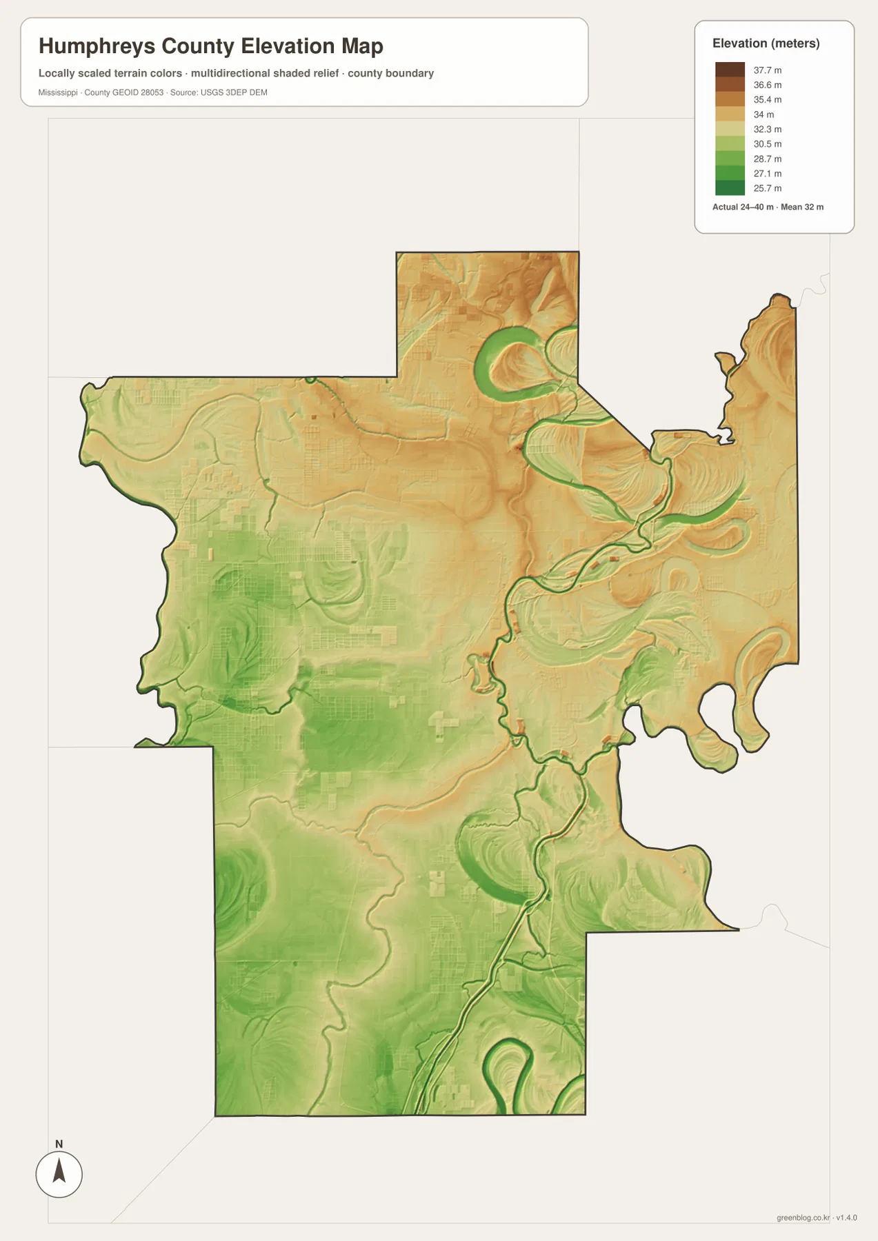
The elevation map is especially useful because Humphreys County has very little vertical relief compared with hillier parts of Mississippi. The supplied map shows an actual range of roughly 24 to 40 meters, with a mean near 32 meters. That narrow range confirms how low and level the county is, but the colors still reveal small differences that can be difficult to notice from a conventional road map.
Lower green areas are more common across parts of the west and southwest, while somewhat higher tan and brown areas appear in the north and east. The Yazoo River corridor and old meandering channels create narrow low zones that stand out against nearby ground. Even a difference of only several meters can be visible when the map is locally scaled to this county rather than using one statewide elevation range.
The elevation surface is appropriate for comparing relative high and low areas within the county. It should not be used as a substitute for a field survey, engineering plan, or site-level construction measurement. For those tasks, a user needs the original elevation data and professional or project-specific measurements.
Which Map Is Most Useful for Your Task?
For a first look at Humphreys County, start with the county map because it provides the clearest combination of boundaries, towns, and numbered roads. If the question is how the main communities are arranged around Belzoni, the city-connections map is quicker because it highlights the hub and straight-line distances. The water map is the better choice for locating the Yazoo River, named lakes, and smaller channels, while the elevation map makes the subtle differences across the Delta lowlands easier to see.
The downloadable archive contains the high-resolution JPG counterparts to the maps shown on the page. The WebP images are optimized for web viewing, while the JPG files are more convenient for printing, classroom handouts, presentation slides, or offline reference. Road, water, and boundary information on a general reference map can change or may not match the precision required for legal and engineering work, so current agency data should be checked when accuracy at that level matters.
Frequently Asked Questions
Are the distances from Belzoni driving distances?
No. The city map shows straight-line distances: about 8 miles to Isola, 6 miles to Silver City, and 15 miles to Louise. Actual road mileage will be longer or different depending on the route.
How flat is Humphreys County on the supplied elevation map?
The map shows an elevation range of about 24–40 meters with a mean near 32 meters. That is a narrow range, but small differences remain visible between river-related low ground and slightly higher parts of the north and east.
Can the water map be used to determine flood risk?
No. It is a reference map for rivers, lakes, creeks, bayous, and drainage channels. Flood-zone decisions should be based on the current official flood maps and related agency information.
Sources and Reference Data
- U.S. Census Bureau QuickFacts for Humphreys County
- U.S. Census Bureau Gazetteer Files
- Mississippi Department of Transportation Official Highway Map
- USGS National Hydrography
- USGS 3D Elevation Program
Map File Information
The ZIP contains high-resolution JPG versions of the Humphreys County county, city, water, and elevation maps shown on this page.
- Included Files: 4 high-resolution JPG map files shown in this article
- File Type: JPG files in a ZIP archive
- Intended Use: Printing, education, presentations, and map-based projects
Related Maps
Green Map creates custom-edited map images using open geographic data sources such as geoBoundaries, Natural Earth, OpenStreetMap, and government open data. These maps are edited visual materials, not raw data files, and are provided for education, documents, presentations, and graphic reference.