This Dallas County Texas map page includes downloadable A3 high-resolution JPG files for the county map, city map, terrain-and-water map, and elevation map. Dallas County is an intensely urban part of North Texas, with Dallas near the center and major cities such as Irving, Garland, Mesquite, Grand Prairie, and Carrollton spread toward different edges of the county. The four supplied maps make it possible to separate that complicated geography into clearer layers: urban centers and roads on one view, waterways on another, and the county’s surprisingly varied relief on the elevation map.
The strongest geographic contrast is between the dense metropolitan core and the physical features that remain visible beneath it. The general county map is crowded with roads and city names, while the water map reveals the Elm Fork and West Fork joining near Dallas to form the main stem of the Trinity River. The elevation map changes the picture again, showing a pronounced rise in the southwest around Cedar Hill and the Mountain Creek Escarpment. Reading the layers together helps explain why Dallas County is more than a flat urban rectangle on a regional map.
Table of Contents
Dallas sits at the center of a county filled with connected cities
Dallas County is very different from a county where one seat dominates a wide rural hinterland. Dallas anchors the middle of the map, but a chain of substantial cities continues in almost every direction. Irving occupies the western side, Richardson and Carrollton are toward the north, Garland and Rowlett lie to the northeast and east, Mesquite is farther east, and DeSoto, Lancaster, Cedar Hill, and parts of Grand Prairie frame the southern and southwestern sides. The urban pattern is dense enough that the spaces between labeled communities can be as important as the labels themselves.
The county boundary also touches six neighboring counties: Denton and Collin to the north, Rockwall and Kaufman to the east, Ellis to the south, and Tarrant to the west. On the supplied county map, major roads continue straight across those boundaries, reflecting the fact that the Dallas-Fort Worth urban area does not stop at the county line. For orientation, it helps to treat the neighboring counties as directional markers. Irving and Grand Prairie point toward the Tarrant side, Garland and Rowlett toward Rockwall and Collin, and Mesquite toward the Kaufman side.
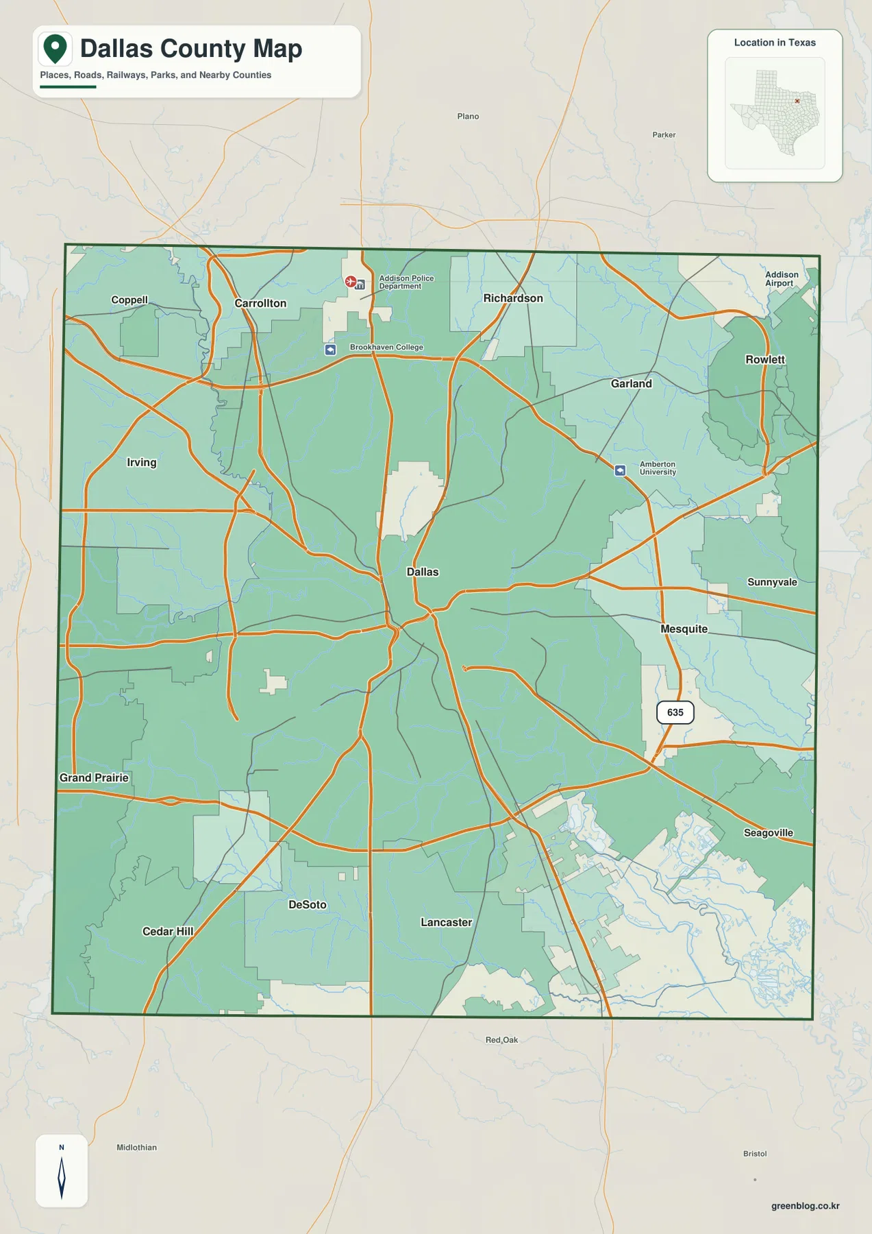
The city map makes the six largest labeled centers easier to compare
The supplied city-index map highlights Dallas, Irving, Garland, Grand Prairie, Mesquite, and Carrollton as six major cities. Dallas is placed near the middle of the county, Irving to the west, Garland to the northeast, Mesquite to the east, Grand Prairie near the southwest side, and Carrollton near the northern edge. Because the map removes much of the road and terrain detail, it is the quickest view for understanding how the main population centers are distributed rather than clustered along a single line.
Those city markers should be read as location references, not as exact municipal boundaries. Several cities in the Dallas-Fort Worth area extend to or across county lines, and the metropolitan built-up area continues into neighboring counties. If the question is simply “which direction is Garland from Dallas?” the city map is ideal. If the question involves legal city limits, county jurisdiction, or a specific street, the general map and current official boundary data are the better sources.
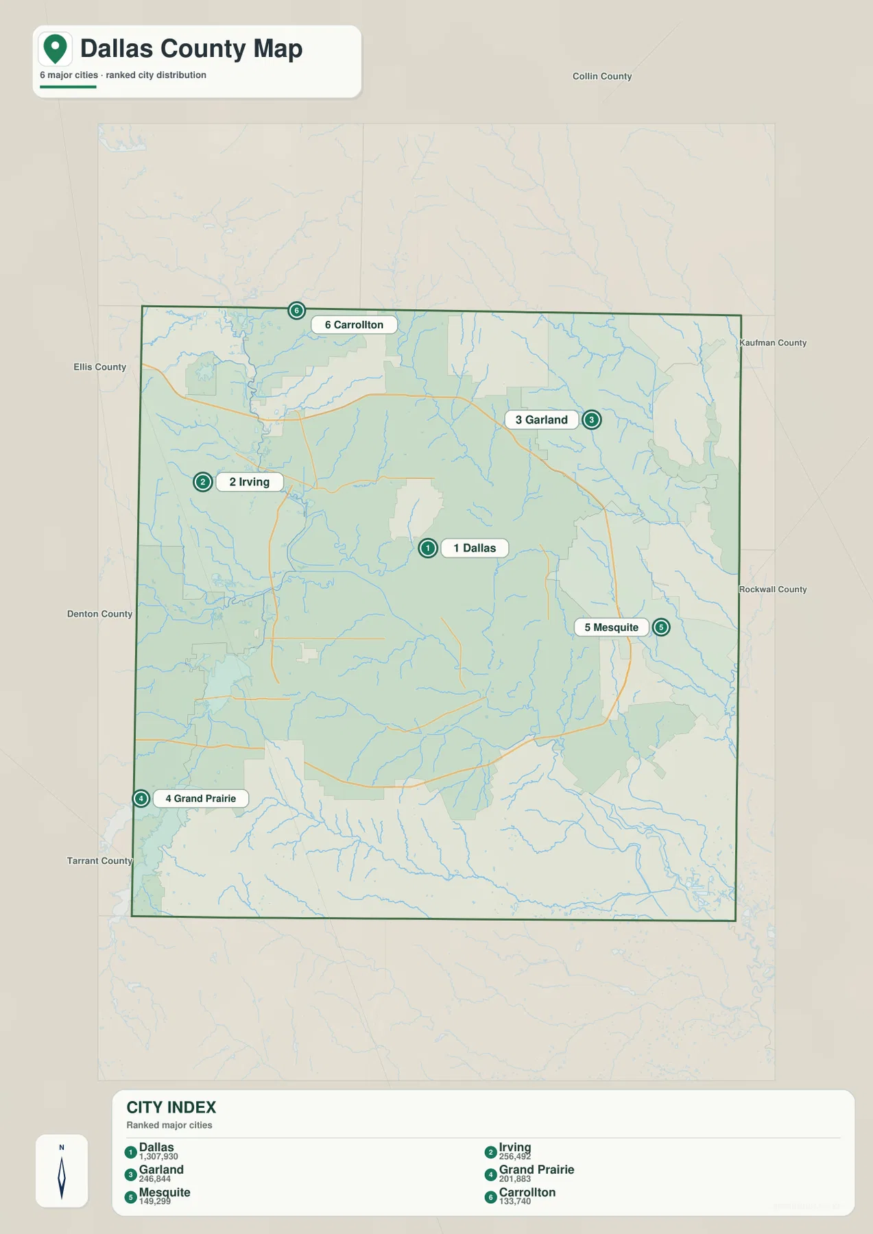
Major highways spread out from Dallas and link each side of the county
The road network is one of the most visually dominant features on the general map. I-35E creates a strong north-south route through the central part of the county, I-30 runs east-west across the urban area, I-45 leaves Dallas toward the south, and I-635 forms an important cross-county route through the northern and eastern suburbs. Numerous other expressways and major arterials fill the spaces between them. Rather than trying to memorize every orange line, a reader can use those principal routes to establish direction and then add local streets only when needed.
This radial and cross-town road pattern matches the spread of cities. A trip from Dallas to Irving heads west, Garland lies on the northeastern side, Mesquite is east, and Grand Prairie sits toward the Tarrant County side. The map also makes clear that many important trips continue beyond Dallas County itself. Northbound routes connect with Denton and Collin counties, western routes enter Tarrant County, and eastern routes continue toward Rockwall and Kaufman counties. That continuity is why the county line is useful for jurisdiction but less useful as a visual boundary for the metropolitan transportation system.
The Trinity River begins where the Elm and West forks meet near Dallas
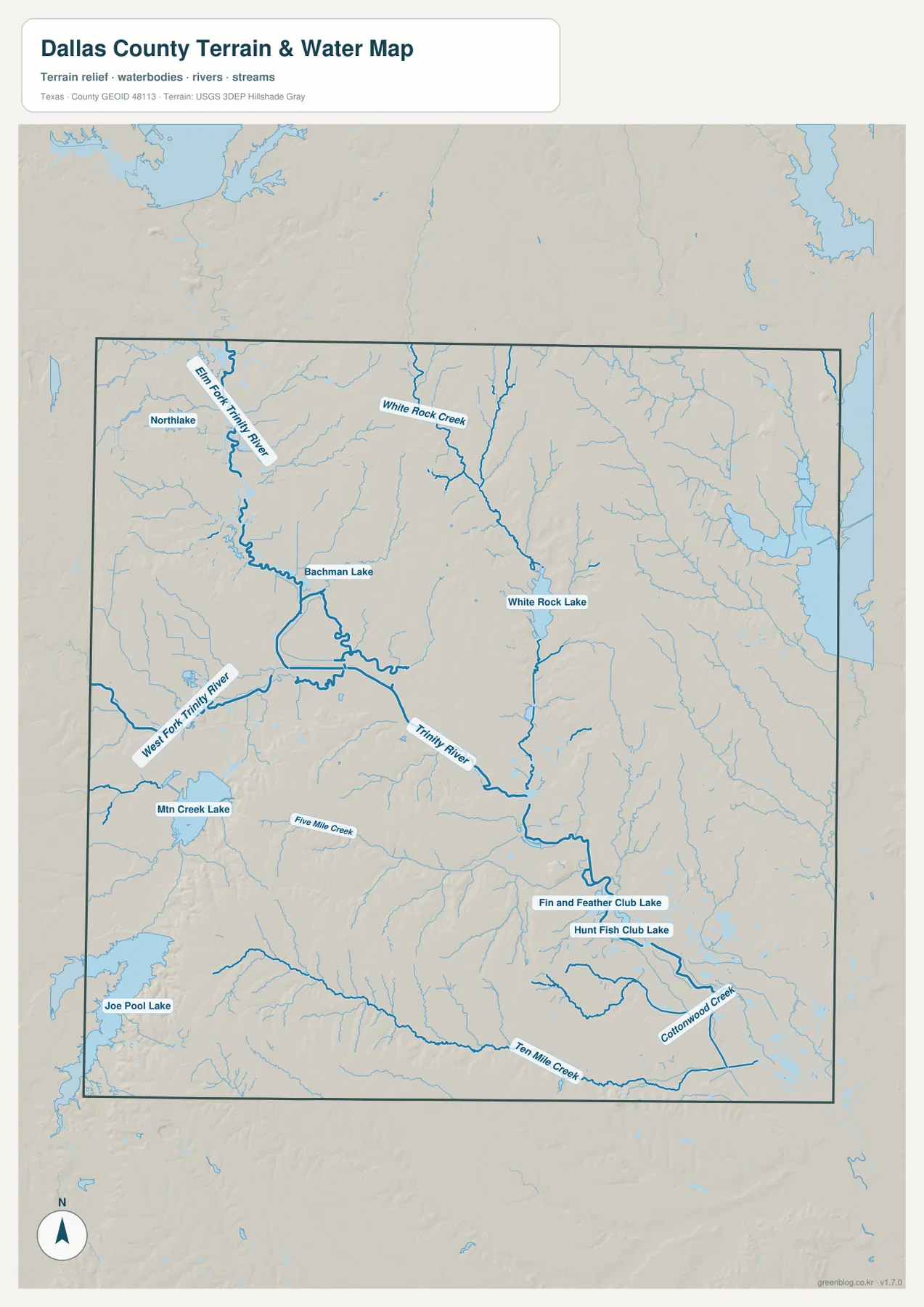
The terrain-and-water map strips away much of the metropolitan clutter and reveals the county’s drainage system. The Elm Fork of the Trinity River comes down from the northwest, while the West Fork approaches from the west. They meet near Dallas, and the main stem of the Trinity River continues southeast from that confluence. USGS material on the Trinity Basin identifies the same confluence as the beginning of the river’s main stem. This is one of the most useful physical reference points in the county because it links the water map directly to the central city.
Smaller water features add detail to different parts of Dallas County. White Rock Creek runs south into White Rock Lake on the eastern side of central Dallas, while Bachman Lake is northwest of the city center. Mountain Creek Lake and Joe Pool Lake appear in the western and southwestern part of the county. Five Mile Creek and Ten Mile Creek cross the south, and Cottonwood Creek is labeled farther southeast. These features make the water map useful for park, watershed, and neighborhood orientation even when the general county map feels dominated by highways.
Cedar Hill and the southwest rise well above the central Trinity corridor
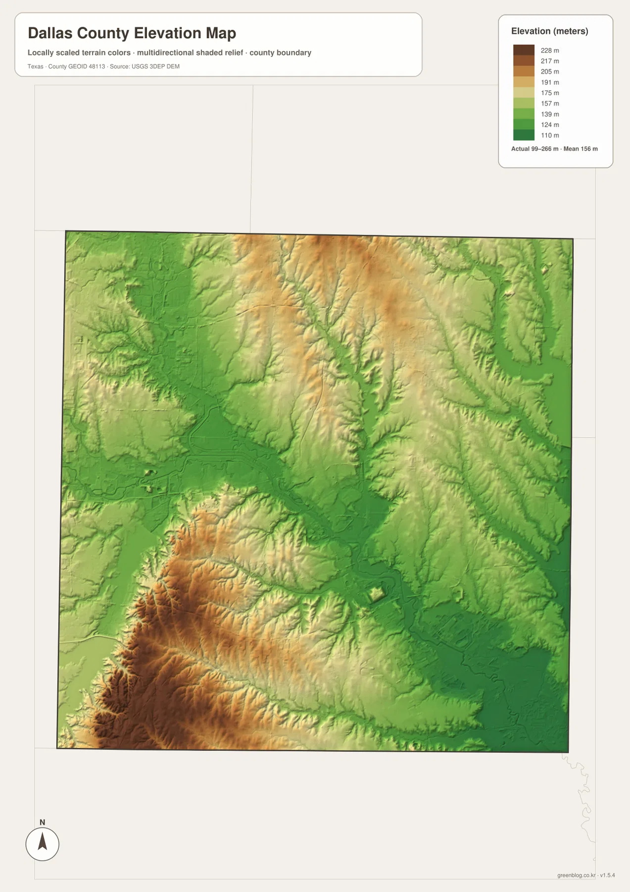
The elevation map provides the biggest visual surprise. Its note gives an actual county range of roughly 99 to 266 meters with a mean near 156 meters. Much of central Dallas County is shown in green and light green, while the southwest around Cedar Hill, Mountain Creek, and the escarpment becomes yellow, brown, and dark brown. The contrast is especially strong near the southwestern corner, where short ridges and dissected slopes stand out against the lower metropolitan terrain.
Dallas County’s 2024 Open Space Plan explains the larger setting: most of the county belongs to the Blackland Prairie, while the Mountain Creek Escarpment crosses the southwest. County pages for Cedar Ridge Preserve and Cedar Mountain Preserve describe substantial local relief, with Cedar Mountain including points above 700 feet. Those official descriptions fit the supplied elevation map closely. The high southwest is therefore not a decorative shading effect; it represents one of the county’s most distinctive natural contrasts.
Blackland Prairie, river greenbelts, and the escarpment still shape the urban county
Dallas County is heavily developed, but its natural geography has not disappeared beneath the city. The county’s open-space planning documents place most of the area in the Blackland Prairie ecoregion and identify a smaller Cross Timbers presence in the northwest. They also note that many preserves are associated with the Trinity River system and that the Mountain Creek Escarpment has long been a focus for conservation in the southwest. These are useful facts when moving between the water and elevation maps because they explain why some corridors remain visibly greener or more rugged than the surrounding urban fabric.
The county’s preserve system gives those landforms real place names. Cedar Ridge and Cedar Mountain are tied to the higher southwest, while Trinity River preserves follow sections of the river and its tributaries. Spring Creek-related preserves lie near Garland, and Tenmile Creek Preserve is in the southern part of the county. The maps on this page are not parcel, property, or park-boundary maps, so they should not be used to determine legal access. They are better used to see where the larger water and terrain features sit relative to the cities.
Use a different map for city location, water, or relief
The general county map is the best starting point when the goal is to combine cities, roads, and the county boundary. The city-index map is faster when the only question is how Dallas, Irving, Garland, Mesquite, Grand Prairie, and Carrollton are positioned relative to one another. For the confluence of the Trinity forks, White Rock Lake, Joe Pool Lake, and named creeks, the terrain-and-water map is much clearer. The elevation map is the right choice for comparing the low central river corridor with the high southwest around Cedar Hill.
A useful way to compare layers is to keep one place fixed while switching maps. Locate central Dallas on the county map, then move to the water map and find the Elm Fork-West Fork confluence, and finally check the surrounding low terrain on the elevation map. Do the same with Cedar Hill and the southwest: its urban location is easy to find on the general map, but the reason that area feels different physically becomes much clearer on the elevation layer. This method is more informative than forcing every label, river, and height band onto a single crowded image.
Download the A3 JPG set for printing, classroom use, or offline reference
The WebP previews on the page are convenient for browsing, while the downloadable archive is intended for readers who want larger files for printing, presentations, classroom handouts, or side-by-side comparison. The ZIP contains four high-resolution A3 JPG files matching the county map, city map, terrain-and-water map, and elevation map shown here. Keeping each subject in a separate image also makes labels easier to read when the map is printed at a reduced size.
These files are general geographic references, not real-time navigation, survey, parcel, flood-warning, or construction maps. Dallas County’s transportation network and developed areas can change quickly, so current agency sources should be checked whenever a decision depends on today’s road conditions, legal boundaries, hazard information, or exact measurements. For ordinary location study and map comparison, however, the four layers provide a compact view of one of Texas’s most geographically complex urban counties.
Frequently Asked Questions
Where does the main Trinity River begin on the Dallas County water map?
Follow the Elm Fork from the northwest and the West Fork from the west. They meet near Dallas, and the main stem of the Trinity River continues southeast from that confluence. This junction is much easier to see on the terrain-and-water map than on the road-heavy general map.
Why is Cedar Hill so prominent on the elevation map?
Cedar Hill lies in the higher southwestern part of Dallas County along the Mountain Creek and White Rock escarpment area. The supplied elevation map shows the southwest in brown and dark brown, clearly above the lower central and eastern terrain. Dallas County preserve information also describes major elevation change around Cedar Ridge and Cedar Mountain.
Which map is best for comparing the major cities?
Use the city-index map when the main goal is to compare Dallas, Irving, Garland, Grand Prairie, Mesquite, and Carrollton without the distraction of the full road network. Switch to the general county map if you also need highways and county boundaries, or add the water and elevation maps when the question involves rivers, lakes, or terrain.
Sources and Reference Material
The description was checked against the city, road, water, and elevation information visible in the supplied maps and the public sources below. Use current agency data when exact measurements, legal boundaries, or recently changed infrastructure are important.
- Dallas County 2024 Open Space Plan – Blackland Prairie, Trinity River greenbelts, and Mountain Creek Escarpment context
- Dallas County Cedar Mountain Preserve – local elevation and escarpment background in Cedar Hill
- Handbook of Texas: Dallas County – county location, neighboring counties, terrain, and Trinity River drainage
- U.S. Census Bureau TIGER/Line Shapefiles – administrative boundaries and road reference
- USGS National Hydrography – river, creek, and water-feature data
- USGS 3D Elevation Program – elevation and terrain data
Map File Information
The ZIP contains four high-resolution A3 JPG files matching the Dallas County general map, city map, terrain-and-water map, and elevation map shown on this page.
- Included Files: 4 high-resolution maps
- File Type: JPG
Related Maps
- Rockwall County Texas map
- Tarrant County Texas map
- Wise County Texas map
- Navarro County Texas map
- Van Zandt County Texas map
Green Map creates custom-edited map images using open geographic data sources such as geoBoundaries, Natural Earth, OpenStreetMap, and government open data.
These maps are edited visual materials, not raw data files, and are provided for education, documents, presentations, and graphic reference.