Download the high-resolution JPG originals for this Greater Bridgeport Planning Region Map in the ZIP below. The page shows the regional boundary and major roads, Bridgeport as the ranked city center, and water features ranging from the Pequonnock and Mill rivers to inland reservoirs and the Long Island Sound coast. The WebP versions are convenient for quick browsing, while the full-size JPG files are better for printing, close viewing, and offline reference.
Greater Bridgeport Planning Region brings together six municipalities with noticeably different landscapes. MetroCOG identifies Bridgeport, Easton, Fairfield, Monroe, Stratford, and Trumbull as its six members. Bridgeport, Fairfield, and Stratford are coastal communities, while Easton, Monroe, and Trumbull are inland. That difference is visible on the maps: the southern portion has a dense road network and urban shoreline, while the north contains more streams, reservoirs, wooded areas, and widely spaced place labels.
Table of Contents
From Bridgeport’s coast to Trumbull, Easton, and Monroe
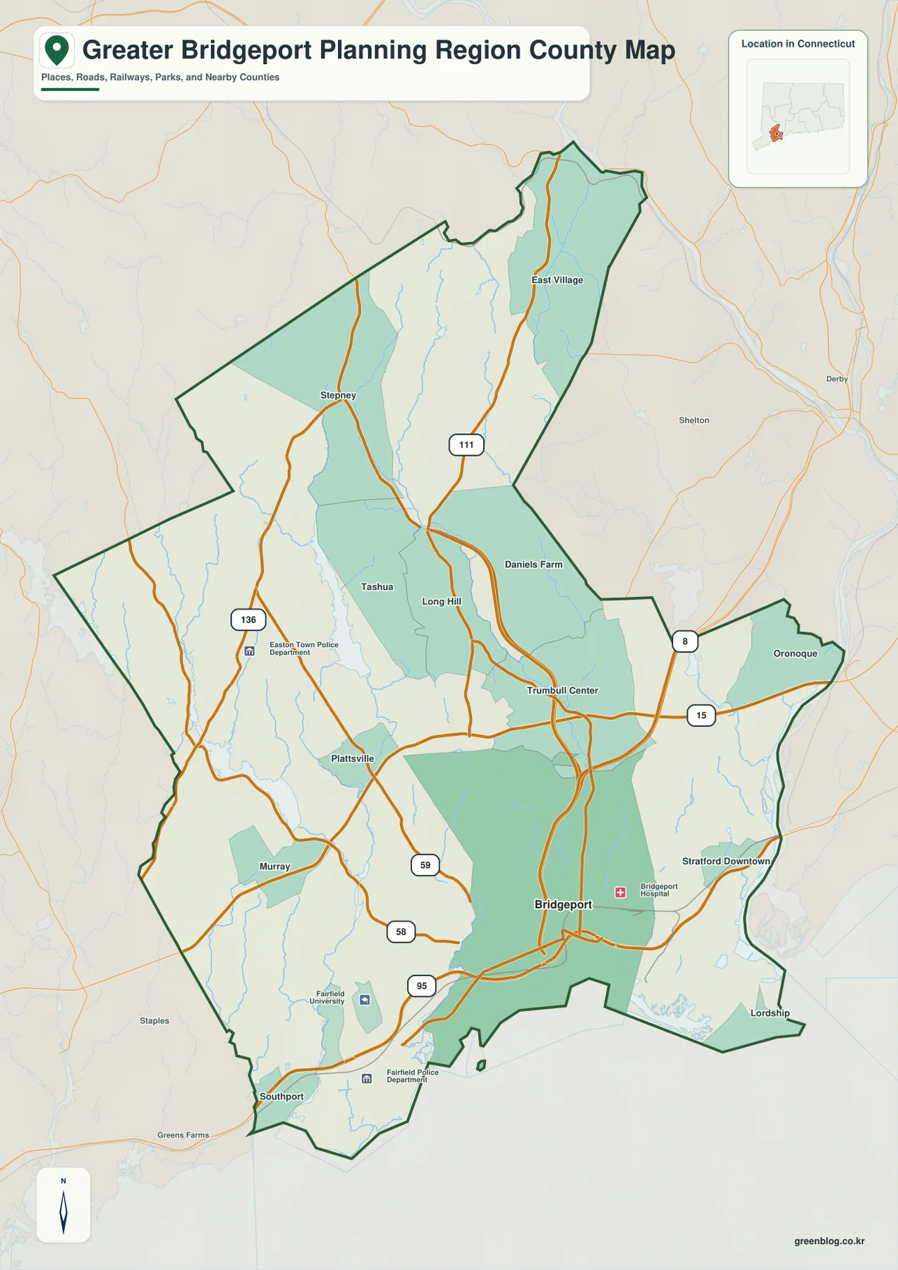
Bridgeport is the strongest reference point on the boundary and road map. The urban street pattern is concentrated near the southern coast, with Stratford Downtown and Oronoque to the east and Trumbull Center, Long Hill, Daniels Farm, and Tashua farther north. Southport, Murray, Plattsville, Stepney, and East Village provide additional location markers across the western and northern portions of the region. Together they show a rapid transition from a dense coastal city to lower-density inland communities.
I-95 is the clearest east-west transportation route along the Bridgeport coastal area, while Route 8 runs north from the city. Route 15 crosses the Trumbull–Stratford portion of the region, and Route 111 continues north through Trumbull toward the Monroe side. Routes 136, 58, and 59 provide useful references on the Fairfield–Easton side. The inland road network is still extensive, but it is much less tightly packed than the streets and highway connections around Bridgeport.
The regional outline should not be confused with the full historic Fairfield County boundary. Greater Bridgeport Planning Region represents the six MetroCOG municipalities, while nearby places such as Shelton and Derby belong outside this planning-region boundary. The map is useful for general regional orientation and transportation reference, not for parcel boundaries or legal municipal-line determinations.
Bridgeport is the only ranked major city on the city layer
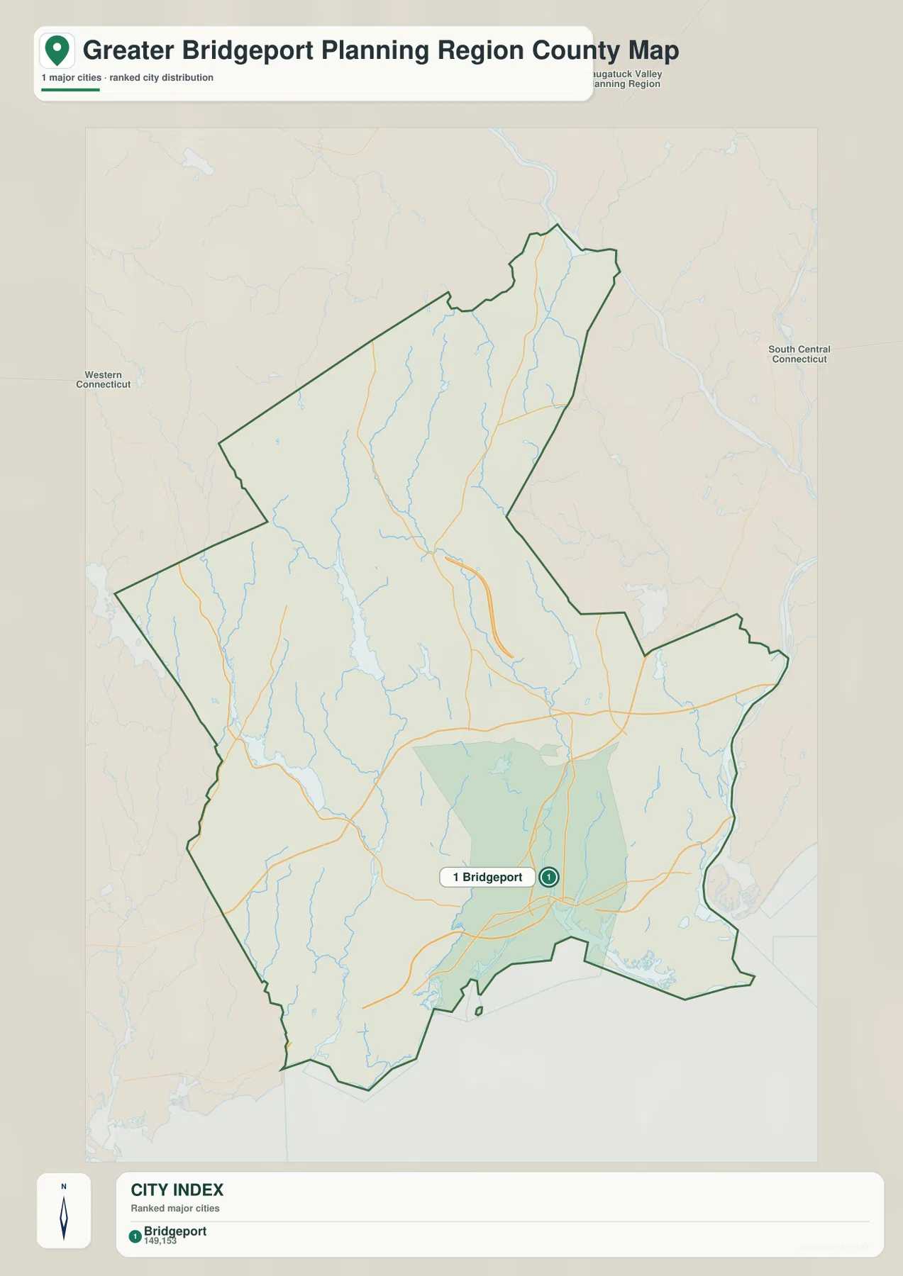
The city layer is a ranked distribution map rather than a distance-connector map. Its CITY INDEX contains one major city, Bridgeport, ranked first. No straight-line mileage or driving distance is drawn to another city, so the layer should be read as a simple picture of where the region’s principal urban center sits within the much larger planning-region outline.
Bridgeport is positioned close to the southern shoreline, leaving most of the northern half without another ranked-city marker. That visual difference matches MetroCOG’s description of Bridgeport as the urban core of a region whose coastal municipalities are more developed while its inland municipalities are more rural. The city layer therefore highlights not just Bridgeport’s location but the strong contrast between the coastal core and the inland part of the region.
Neighboring planning-region labels such as Western Connecticut, Naugatuck Valley, and South Central Connecticut help place Greater Bridgeport within the state’s modern regional geography. The Greater Bridgeport boundary occupies a relatively compact section of southwestern Connecticut, yet the internal landscape changes quickly from the Bridgeport shoreline to the reservoir and stream country farther north.
Pequonnock River, Mill River, Aspetuck River, and inland reservoirs
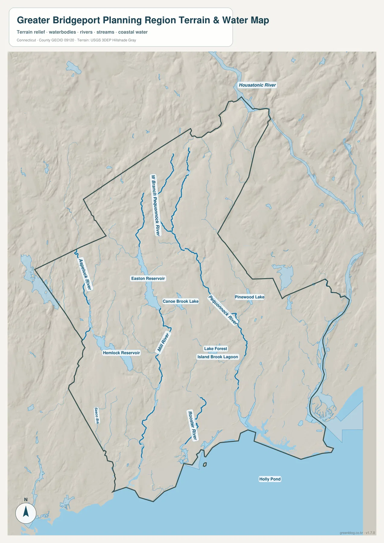
Pequonnock River is the strongest internal water reference on the terrain map. It runs south through the central part of the region toward Bridgeport, while West Branch Pequonnock River follows a separate tributary course farther west. Comparing the water and road maps makes the river’s relationship with Trumbull and the Bridgeport urban area especially clear: a stream corridor that begins in the inland portion of the region continues directly toward the coast.
West of the Pequonnock system, Mill River and Aspetuck River form two important north-south drainage corridors. Easton Reservoir and Canoe Brook Lake are labeled near the Mill River side, while Hemlock Reservoir provides another large inland water reference farther west. These water bodies make the Easton–Fairfield side easier to orient on the terrain map, where streams and reservoirs are more useful landmarks than the dense urban streets found closer to Bridgeport.
The eastern and southern parts of the region contain a different set of water features. Pinewood Lake appears in the Trumbull area, Lake Forest and Island Brook Lagoon are labeled near the Bridgeport side, and Rooster River flows south toward the coastal portion of the region. Sasco Brook is visible near the southwestern edge. Together, these features show a compact planning region with a surprisingly varied mix of coastal water, urban streams, inland lakes, and public-water reservoirs.
Housatonic River is labeled beyond the northeastern side of the regional outline and provides useful context for the Stratford–Shelton side of southwestern Connecticut. Along the south, the region opens onto Long Island Sound through Bridgeport, Fairfield, and Stratford. This water layer is intended for general geographic reference and should not be used as a flood-hazard map, drinking-water protection boundary, water-rights document, legal channel boundary, or navigation chart.
Why the planning-region boundary matters
Connecticut now uses nine planning regions as geographic frameworks for regional coordination. MetroCOG represents the Greater Bridgeport region and works with Bridgeport, Easton, Fairfield, Monroe, Stratford, and Trumbull on transportation, land use, environmental planning, hazard mitigation, economic development, shared services, and mapping. The outline on this page therefore represents a regional planning unit made from six municipalities rather than one enlarged city or the full historical county.
The U.S. Census Bureau also publishes Greater Bridgeport Planning Region in Connecticut’s county geography, using GEOID 09120. As a result, the name can appear in datasets and tools that are organized by county even though the public-facing regional unit is a planning region. Keeping that distinction clear prevents the downloaded boundary from being mistaken for the old Fairfield County geography.
Reading the coastal core and inland watershed together
The southern side is easiest to understand through Bridgeport, Stratford, Fairfield, I-95, and Route 8. The road map is dense, the shoreline is close, and the water layer shows Pequonnock and Rooster rivers reaching the coastal urban area. Lake Forest and Island Brook Lagoon add smaller water landmarks within the same developed part of the region.
North of Trumbull, streams and reservoirs become stronger reference points. West Branch Pequonnock River, Mill River, and Aspetuck River cross the inland landscape, while Easton Reservoir, Hemlock Reservoir, and Canoe Brook Lake stand out clearly. Looking back and forth between the road and water maps shows why Greater Bridgeport should be understood as more than a coastal city: the same regional boundary also includes wooded reservoir country and lower-density inland communities.
Which map should you use first?
Start with the boundary and road map when you need Bridgeport, the Trumbull–Easton–Fairfield–Stratford directions, major highways, and the planning-region outline in one view. The ranked city map is the fastest way to see Bridgeport’s position as the single highlighted major city, but it does not provide mileage. Use the water and terrain map for Pequonnock River, Mill River, Aspetuck River, Rooster River, inland reservoirs, lakes, and the coastal edge.
For example, compare the road and water maps to follow the Bridgeport–Trumbull corridor and see how Route 8, Route 15, and Pequonnock River occupy the same general part of the region. On the Easton side, Routes 136 and 58 are easier to understand when compared with Easton and Hemlock reservoirs. This package contains the boundary/road, ranked city, and water/terrain maps only, so the article does not invent an elevation layer that is not supplied.
Frequently Asked Questions
Which municipalities are in Greater Bridgeport Planning Region?
MetroCOG identifies six member municipalities: Bridgeport, Easton, Fairfield, Monroe, Stratford, and Trumbull. Bridgeport, Fairfield, and Stratford are coastal communities, while Easton, Monroe, and Trumbull are inland.
Does the city map show distances from Bridgeport to other cities?
No. The city layer contains Bridgeport as the single first-ranked major city and does not draw connector lines, straight-line mileage, or driving distances to other places. Use it to understand the location of the region’s main urban center.
Which map is best for the Pequonnock River and inland reservoirs?
The water and terrain map is the best choice. It shows Pequonnock River and its west branch, Mill River, Aspetuck River, Rooster River, Easton and Hemlock reservoirs, Canoe Brook Lake, Pinewood Lake, Lake Forest, and other water features.
Map File Information
The ZIP contains the original high-resolution JPG versions of the boundary/road, ranked city, and water/terrain maps shown on this page. Use the larger files for printing, detailed viewing, or offline reference.
- Included Files: Use only the versions confirmed in the article and supplied images
- File Type: Use the confirmed download contents
- Intended Use: Printing, education, presentations, and map-based projects
Related Maps
Sources and references
- Connecticut Metropolitan Council of Governments – About Us – the six Greater Bridgeport member municipalities and MetroCOG’s regional role
- State of Connecticut – Regional Councils of Governments – Connecticut’s planning-region framework
- U.S. Census Bureau TIGER/Line Shapefiles – planning-region boundaries, roads, and place reference
- USGS National Hydrography – rivers, streams, lakes, and reservoirs
Green Map creates custom-edited map images using open geographic data sources such as geoBoundaries, Natural Earth, OpenStreetMap, and government open data.
These maps are edited visual materials, not raw data files, and are provided for education, documents, presentations, and graphic reference.