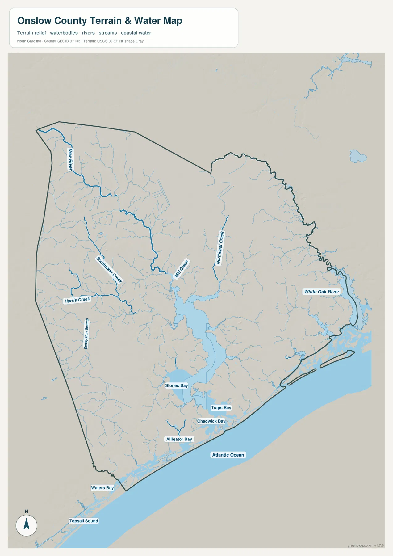
Onslow County sits in southeastern North Carolina where Jacksonville, inland towns, a very large military area, the New River, tidal bays, and the Atlantic coast all fit inside one county. This page includes a county reference map for boundaries and roads, a city-connections map centered on Jacksonville, and a waterways map that names the river, creeks, bays, sound, and coastal water. You can download the same three maps below as high-resolution A3 JPG files in a single ZIP archive, while the WebP versions on the page provide a quick way to check locations and labels before saving the larger files.
Jacksonville is the easiest place to begin, but it does not represent the whole county by itself. Richlands lies to the northwest, Swansboro is on the eastern side, while Holly Ridge and North Topsail Beach provide southern and coastal reference points. The maps also show numbered roads including 17, 24, 53, 111, 172, 210, and 258. On the water map, New River is joined by named creeks and bays before the county opens toward Topsail Sound and the Atlantic Ocean. Looking at those features together makes it much easier to understand why travel, settlement, and waterfront locations differ so much from one part of Onslow County to another.
Table of Contents
Jacksonville, county boundaries, and the main road network
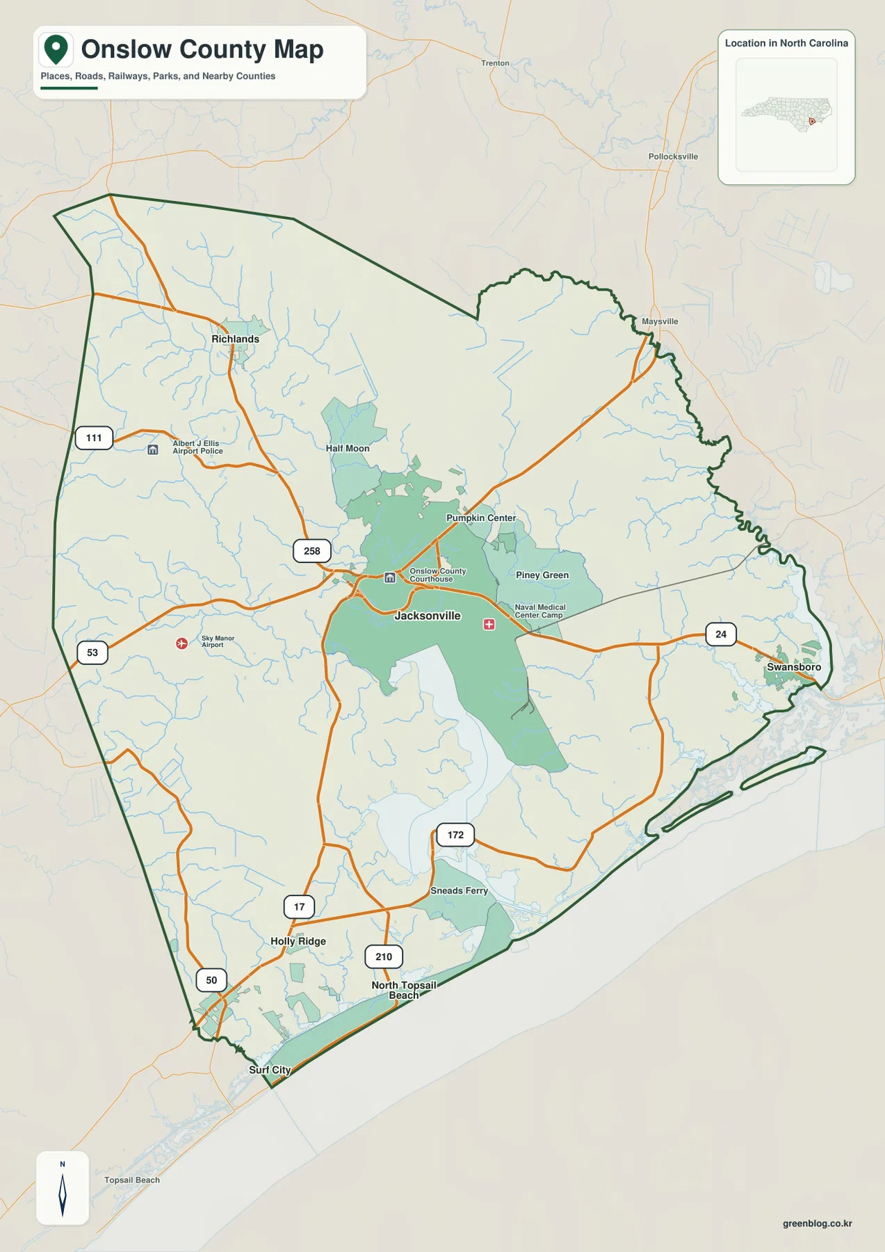
The county reference map places Jacksonville near the center and gives it several useful landmarks. The Onslow County Courthouse is labeled near the city core, while Naval Medical Center Camp Lejeune appears to the east. Albert J Ellis Airport is shown west of Jacksonville and Sky Manor Airport is marked farther southwest. These labels are practical orientation points: they help a reader locate the central city before following the roads toward Richlands, Swansboro, Sneads Ferry, Holly Ridge, and the coast.
Several numbered routes create a visible framework across the county. Road 53 approaches Jacksonville from the west, 258 helps define the northwest side near Richlands, and 24 runs eastward through Piney Green toward Swansboro. South of Jacksonville, roads 17, 172, and 210 help organize the route toward Holly Ridge, Sneads Ferry, North Topsail Beach, and the southern shoreline. Road 111 is also marked in the western part of the county. The map is not a turn-by-turn navigation product, but the road labels are detailed enough to show which communities share the same general travel direction.
The county outline also reveals a strong contrast between the inland edges and the southeastern shoreline. Smaller streams cross much of the interior, while the lower and eastern side becomes increasingly shaped by broad water. Nearby labels such as Maysville, Pollocksville, and Trenton appear outside the boundary and help place Onslow within the surrounding part of eastern North Carolina. Because the background includes roads and place names beyond the county line, a reader can see where a trip is leaving Onslow rather than treating the boundary as an isolated shape.
How Richlands, Swansboro, and the beach communities sit around Jacksonville
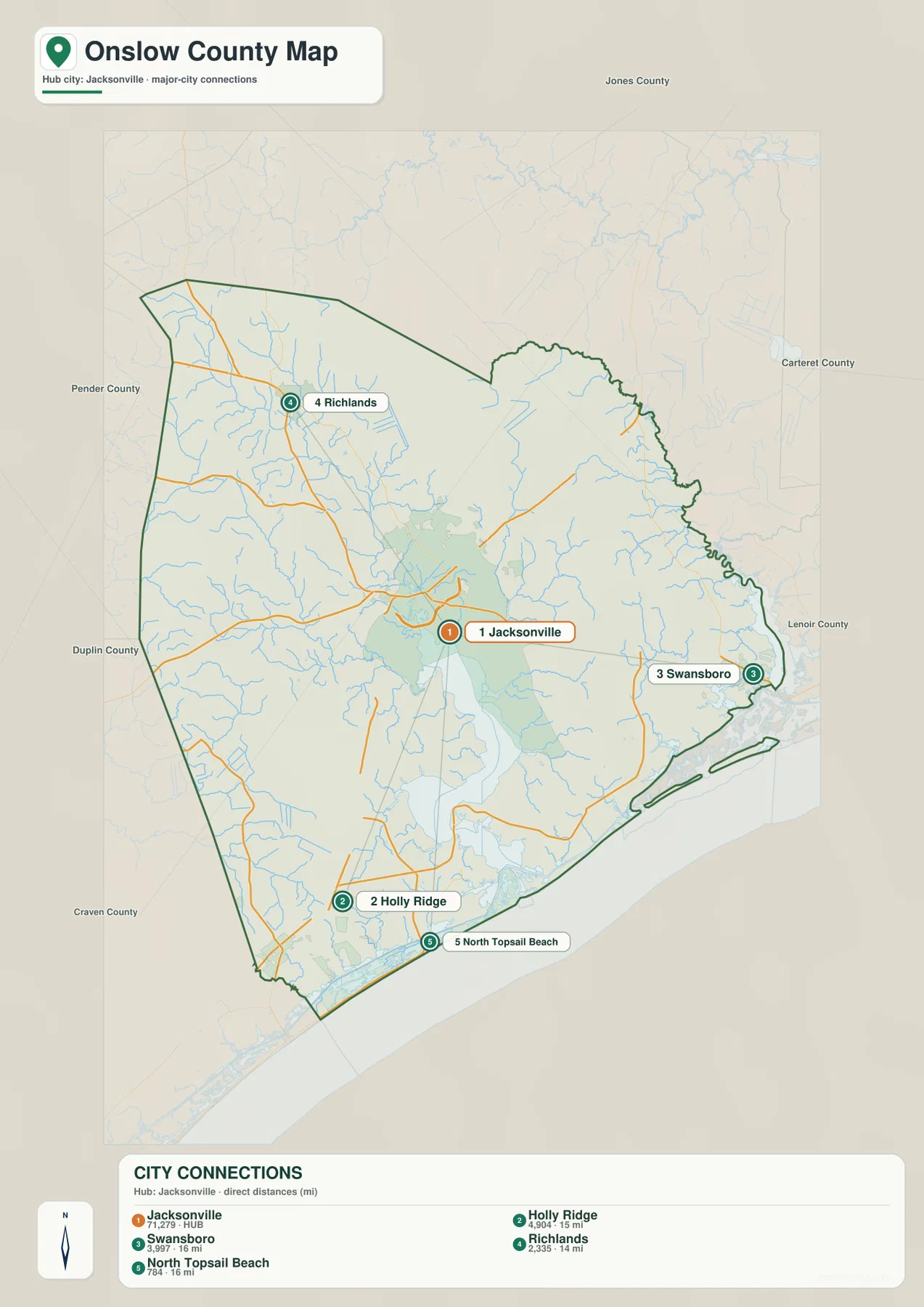
The city-connections map strips away some of the detail and makes the settlement pattern easier to compare. Jacksonville is the hub. Richlands is northwest of it, Swansboro is east, Holly Ridge is southwest, and North Topsail Beach is near the southern coast. The distances shown in the map are straight-line distances from Jacksonville, not road-driving distances. That distinction matters because water, military land, and the shape of the road network can make an actual trip longer than the simple point-to-point measurement suggests.
Richlands is the clearest inland counterpoint to the coastal communities. It sits northwest of Jacksonville in an area crossed by many small streams and connected toward the center through the road network shown on the reference map. Swansboro provides a different orientation on the eastern side. Road 24 gives the most obvious visual connection between Jacksonville, Piney Green, and Swansboro, so the two cities are easy to compare without assuming that they share the same waterfront setting.
Holly Ridge and North Topsail Beach show how the county changes toward the south. Holly Ridge is inland from the immediate shoreline and close to road 17, while North Topsail Beach sits along the narrow coastal strip. Surf City is visible just beyond the lower boundary on the broader reference map, adding another useful place name for orientation along the coast. These southern labels are especially helpful for visitors who know the beach area better than Jacksonville and want to work backward toward the rest of the county.
Other community names on the reference map, including Half Moon, Pumpkin Center, Piney Green, and Sneads Ferry, fill in the space between the five highlighted city points. They show why a simple Jacksonville-versus-coast description would be incomplete. Onslow has a central urban area, inland settlements, eastern waterfront communities, and southern beach access points. The city map is most useful when a reader wants that broad pattern before opening the more detailed road or water views.
Following New River from inland creeks to bays and the Atlantic
New River is the strongest natural reference on the waterways map. It enters the map from the northwest, bends through the county, and becomes much broader south of the Jacksonville area before reaching the coast. New River is roughly 40 miles long and both begins and reaches the sea within Onslow County. Whether or not a reader knows the smaller communities, following the river immediately provides a north-to-south frame for the center of the county.
Several named tributaries make the inland network more specific. Southwest Creek and Mill Creek approach the New River system from the western and central sides, while Northeast Creek runs through the eastern-central area. Harris Creek and Sandy Run Swamp are also labeled on the west. These names help explain the many fine blue lines that appear on the county reference map: the interior is crossed by numerous small waterways rather than being separated by only one large river.
Farther south, the map changes from narrow river lines to broad bays. Stones Bay is the largest labeled bay close to the widened lower New River, followed by Traps Bay, Chadwick Bay, Alligator Bay, and Waters Bay along the southern part of the county. Topsail Sound is shown near the southwest coast. This sequence is useful around Sneads Ferry and North Topsail Beach because the bay names give a more precise coastal reference than a general statement such as “south of Jacksonville.”
On the eastern side, White Oak River is labeled near the Swansboro area and provides a separate water reference from New River. The Atlantic Ocean fills the southeastern edge of the map, making the relationship between inland creeks, river mouths, sounds, bays, and open coast visible at one scale. This is a geographic reference map rather than a boating chart, so it should not be used for navigation depths or channel safety. Its value is in showing where named communities and roads sit in relation to the county’s major water features.
Why Camp Lejeune and the coast make the county layout unusual
Onslow is not arranged like a county where roads and towns simply spread evenly from the seat. Camp Lejeune covers roughly 156,000 acres, and its establishment in 1941 changed the county’s development pattern. On the reference map, military-related facilities sit close to Jacksonville while a large portion of the central and southeastern county remains visually distinct from the civilian city core. That helps explain why the county contains strong urban, military, river, and maritime elements in close proximity.
This geography also affects how the outer communities relate to Jacksonville. Swansboro lies east across a road network shaped by streams and large managed areas. Sneads Ferry and the southern coast sit beyond the widened New River and its bays. Richlands is oriented toward the inland northwest instead. The locations are not simply four points around a circle, and the combination of road and water maps makes those differences much easier to see than a city list alone would.
Onslow County was formed in 1734, and its modern geography changed substantially with twentieth-century military development. Those facts give useful background for the modern map, but this page is not intended to define property ownership, installation access, or restricted boundaries. For those questions, current information from the responsible agency is necessary. Here, the maps are best treated as visual references for public place names, broad road connections, county geography, and the relationship between communities and water.
Choosing the most useful Onslow map for your task
Use the county reference map when your main question involves roads, boundaries, airports, the courthouse area, or the location of several communities at once. It is the best all-purpose view for seeing how roads 24, 17, 53, 258, 172, 210, and 111 fit around Jacksonville and the rest of the county. It also keeps nearby outside places visible, which can be helpful when a trip continues beyond Onslow.
For comparing direction and separation from Jacksonville, the city-connections map is the clearest starting point. Its listed distances are straight-line measurements, so it works as an orientation graphic rather than a route planner. When New River, White Oak River, creeks, bays, Topsail Sound, or the Atlantic shoreline matters more than roads, the waterways map gives the cleaner view. Moving between these maps makes it possible to compare settlement, transportation, and water features without forcing every label into one crowded image.
For printing, large-screen review, or offline use, the ZIP below contains the high-resolution A3 JPG versions corresponding to the county, city-connections, and waterways maps on this page. The archive name is onslow_county_north_carolina_3_map_jpg.zip. The WebP images in the article are optimized for online preview, while the JPG files preserve the larger source dimensions for readers who need to zoom in on labels or place a map into a document.
Frequently Asked Questions
Which map is best for comparing Jacksonville and Swansboro?
The city-connections map is the quickest choice because Jacksonville is the hub and Swansboro is clearly placed to the east. The distance shown there is a straight-line distance, so it is useful for relative position rather than driving directions. If you need the actual road context, compare it with the county map, where road 24 provides the clearest visual connection toward Swansboro.
What should I follow on the water map to understand New River and the coast?
Start with the New River label in the northwest and follow the river as it bends south and becomes broader. Near the lower part of the county, Stones Bay, Traps Bay, Chadwick Bay, and other bays appear before the open Atlantic coast. Topsail Sound on the southwest side and White Oak River to the east provide additional reference points for the two coastal ends of the county.
What files are included in the downloadable ZIP?
The archive contains three high-resolution A3 JPG files corresponding to the county reference map, city-connections map, and waterways map shown on this page. The WebP versions are intended for faster browser viewing, while the JPG files are the better choice for printing, close inspection, or offline storage.
Map File Information
This ZIP contains high-resolution A3 JPG versions of the Onslow County reference map, city-connections map, and waterways map.
- Included Files: 3 high-resolution A3 JPG maps described on this page
- File Type: JPG files in a ZIP archive
- Intended Use: Printing, education, presentations, and map-based projects
Related Maps
Sources and references
- Onslow County – History and Area – county history and local background
- U.S. Census Bureau TIGER/Line Shapefiles – boundary, road, and place-reference data
- USGS National Hydrography – official hydrography and water-feature data
Green Map creates custom-edited map images using open geographic data sources such as geoBoundaries, Natural Earth, OpenStreetMap, and government open data.
These maps are edited visual materials, not raw data files, and are provided for education, documents, presentations, and graphic reference.