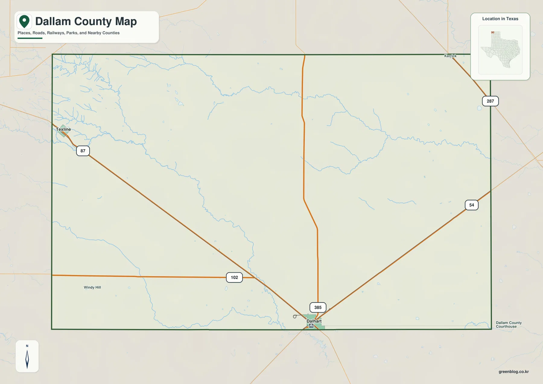
This Dallam County map page provides downloadable high-resolution A3 JPG files in one ZIP archive, along with screen-friendly views of the county boundary, cities, waterways, and elevation. Dallam County occupies the far northwestern corner of the Texas Panhandle, meeting New Mexico on the west and the Oklahoma Panhandle on the north. Dalhart, the county seat, lies along the southern edge of the county, while Texline sits near the opposite corner at the New Mexico line, making the wide separation between the county’s main settlements easy to see.
A simple outline can make Dallam County look almost featureless because much of the land is open High Plains country rather than a dense network of towns. The details become more useful when the maps are read together. Roads converge on Dalhart, U.S. 87 reaches Texline at the state line, intermittent creeks cut across the broad plains, and the elevation surface gradually drops from the higher western side toward the east. Those relationships explain the county better than a long list of place names, especially for readers who are trying to print a map, plan a route, or understand where the few major settlements sit within a very large rural area.
Table of Contents
The northwest corner of Texas gives Dallam County an unusual border setting
Dallam County is the top-left county on a map of the Texas Panhandle. Its western edge is the New Mexico state line, with Union County beyond it, and its northern edge meets Cimarron County in the Oklahoma Panhandle. Sherman County borders Dallam on the east and Hartley County lies to the south. This means that two sides of the county are also state boundaries, so the outer lines matter for more than local administration. A trip west or north crosses into another state almost immediately after leaving the county.
Dalhart provides a useful anchor, but it is not located near the geographic center of the county. The city straddles the Dallam-Hartley county line and serves as the seat of Dallam County. Texline is much farther northwest, close to the New Mexico line at U.S. 87. Finding those two places first gives the map a clear scale: the county is not a compact urban district surrounding one central town, but a broad piece of the High Plains with settlements separated by long stretches of agricultural and grazing land.
Dalhart and Texline show how concentrated the settlement pattern is
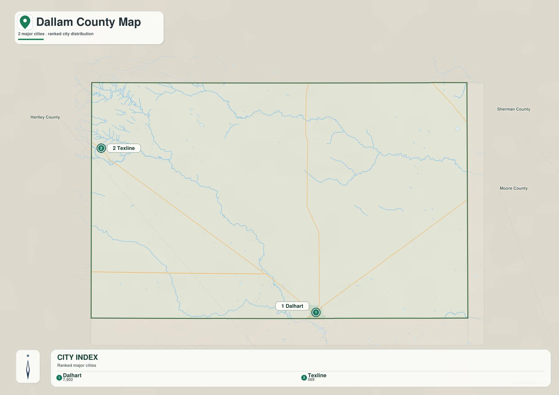
The city map emphasizes two places: Dalhart and Texline. Its city index ranks Dalhart first and Texline second, and the difference between the two is much more important than the ranking itself. Dalhart is the county’s main service and government center at the southern edge, while Texline is a small border community in the northwest. Large areas between them contain no comparable incorporated city, so the visual spacing on the map is a good reminder that Dallam County is predominantly rural.
The broader county map also labels Kerrick near the northern part of the county. That smaller community helps orient readers who are looking beyond the two incorporated places highlighted in the city index. Instead of forming a continuous chain of towns, Dallam County has a few distinct settlement points connected by long roads. For route planning, this matters because a line that looks short at county scale can represent a significant drive through open country with few urban stops.
U.S. 87 links Texline with Dalhart, while several routes meet near the county seat
Roads are especially useful in Dallam County because they provide the easiest way to connect widely spaced places. U.S. 87 enters from the northwest at Texline and runs southeast toward Dalhart. Around Dalhart, the map also shows U.S. 54 and U.S. 385, while U.S. 287 appears along the northeastern side of the county and State Highway 102 approaches Dalhart from the west. Reading these routes together makes Dalhart’s location more understandable: even though the city is near the county line, multiple long-distance corridors converge in or near it.
A practical way to use the road map is to start with a destination rather than trying to memorize every route number. To understand the northwest corner, trace U.S. 87 from Dalhart toward Texline and the New Mexico border. To understand travel toward the northern or eastern plains, look at the highways that leave Dalhart or run along the county’s eastern side. Many routes continue well beyond Dallam County, so the map is most useful when the county boundary is treated as a reference line rather than the end of the transportation network.
Rita Blanca, Coldwater, and Carrizo creeks reveal the county’s hidden drainage
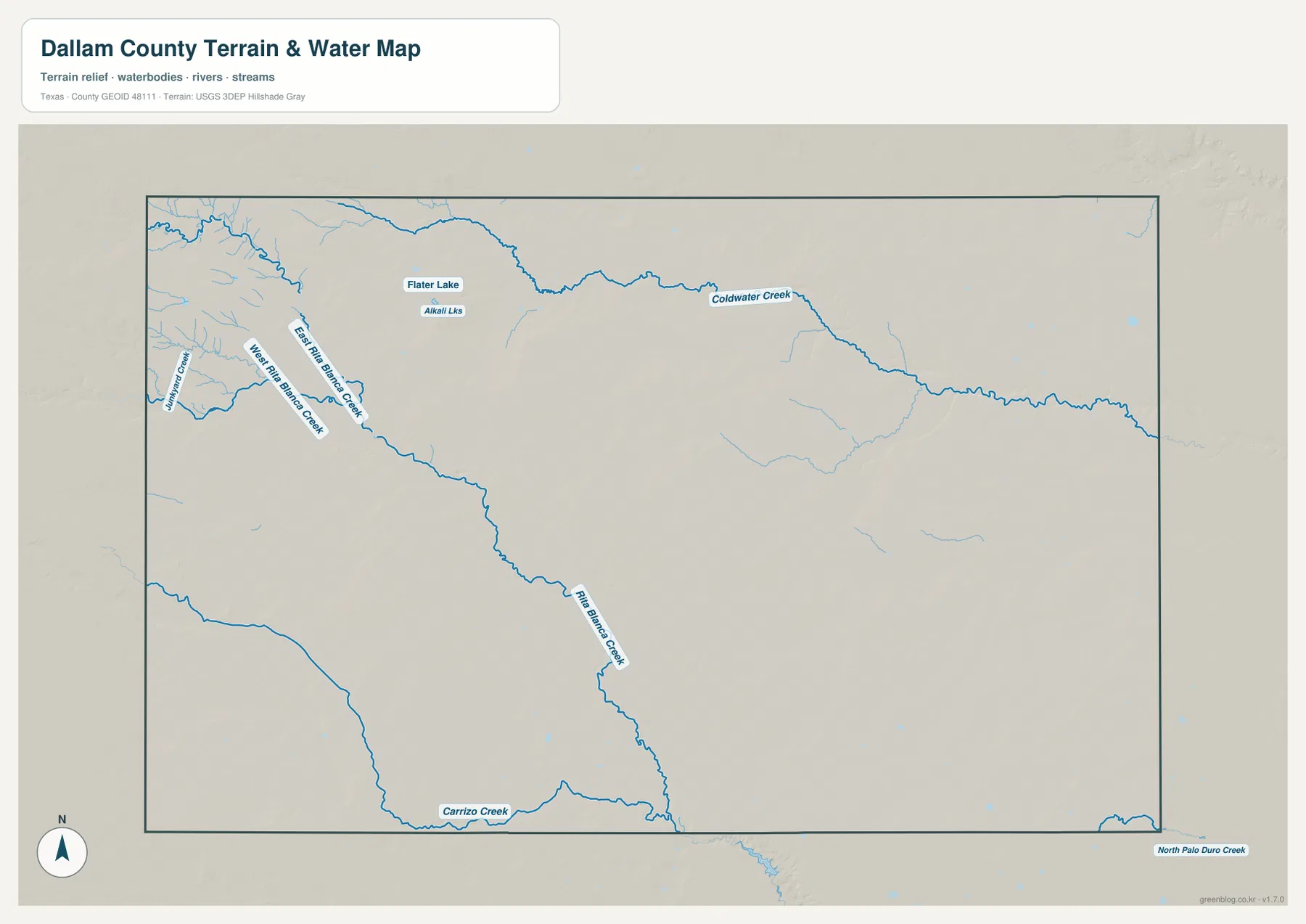
The terrain-and-water map adds detail that is easy to miss on the road map. Branches of Rita Blanca Creek enter the western side of the county and extend southeastward, while Coldwater Creek makes a broad curving path across the northern half. Carrizo Creek is labeled farther south, and smaller features such as Flater Lake and the Alkali Lakes appear near the northern and western parts of the map. Together, these features break up the impression of a perfectly flat, empty plain.
Not every blue line should be interpreted as a large stream carrying water all year. The Handbook of Texas describes Rita Blanca, Carrizo, and Coldwater as intermittent creeks, which is consistent with the dry High Plains setting. On this map, the blue network is best used to locate valleys, drainage courses, and low areas where runoff is directed. Comparing the creek network with the elevation colors is especially helpful because the channels follow lower ground that is not obvious from the county boundary or city map alone.
The elevation surface slopes from higher western plains toward the east
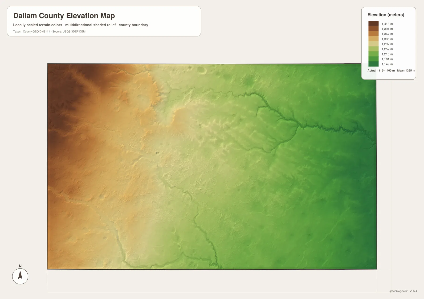
The elevation map shows a broad west-to-east change rather than one isolated mountain or canyon. Brown and tan shades dominate the western side, then transition through yellow into greener lower terrain toward the east. The legend on the provided map gives an actual range of about 1,115 to 1,460 meters, with a mean near 1,265 meters. That is enough relief to shape drainage and local travel without turning Dallam County into mountainous terrain.
Creek valleys become easier to recognize when the elevation map is compared with the water layer. Narrower low corridors cut into the otherwise smooth High Plains surface, particularly along the major drainage lines in the northern and western parts of the county. The result is a landscape that can look almost level from a small-scale road map but still contains a consistent regional slope and many shallow valleys. For teaching or geographic reference, this is a useful example of why a boundary map and an elevation map can tell different stories about the same place.
Rita Blanca National Grassland adds a protected landscape to the northern plains
Open land in Dallam County is not all the same. Portions of Rita Blanca National Grassland lie in the county and extend into the Oklahoma Panhandle. The USDA Forest Service manages the grassland for multiple purposes that include rangeland, watershed, wildlife, and recreation. Its presence is a useful reminder that large blank-looking areas on a general county map may contain public grassland, working ranches, farms, and other land uses that are not shown by a simple road-and-boundary layer.
The broader county landscape is strongly associated with the High Plains, where ranching and grain production have long been important. Those activities help explain why settlements are sparse and why roads often cross long uninterrupted stretches before reaching another town. The maps on this page do not show parcel ownership, legal access, or land-use zoning, so they should not be used to decide whether a particular tract is public or private. For that purpose, readers should consult the appropriate county, state, or federal land records.
The shift from Texline to Dalhart as county seat reflects the transportation history
Dallam County’s settlement history gives extra meaning to the locations on the map. According to the county’s official history, Dallam County was created in 1876 and organized in 1891. Texline, then the only town in the county, became the first county seat. A decade later, Dalhart developed where railroad lines crossed, and the county seat was moved to Dalhart in 1903. The modern map still shows the geographic contrast between the older border town in the northwest and the larger transportation center near the southern county line.
This history also explains why a county seat does not have to sit in the middle of a county. Dalhart’s location makes more sense when transportation connections are considered alongside the administrative boundary. Today, major highways converge there, and the city serves as the principal local center even though part of Dalhart lies in Hartley County. Readers interested in courthouse history or the county-seat move can use the official Dallam County site for the historical details, while the maps here provide the present-day geographic context.
Choose the map that matches the question before downloading the JPG files
For a quick location check, the county map is the best starting point because it combines boundaries, settlements, roads, and some water features. The city map strips away much of that detail and makes the contrast between Dalhart and Texline easier to see. The terrain-and-water map is better for locating named creeks, lakes, and branching drainage lines, while the elevation map shows the regional slope and the low corridors cut into the plains. Using the maps separately keeps labels readable and prevents unrelated information from competing for attention.
If the maps are needed for a classroom handout, printed reference, presentation, or offline comparison, the download archive is more convenient than saving the smaller screen images. The ZIP contains four A3 high-resolution JPG files corresponding to the county map, city map, terrain-and-water map, and elevation map shown on this page. These are general reference maps rather than survey, parcel, navigation, or real-time hazard products, so professional or safety-critical decisions should always be checked against the current authoritative source.
Frequently Asked Questions
Why is Dalhart near the county line if it is the seat of Dallam County?
Dalhart straddles the Dallam-Hartley county line. It grew at a railroad junction and became the Dallam County seat in 1903, replacing Texline. A county seat does not have to sit at the geographic center of a county, so Dalhart’s position near the southern edge reflects the county’s actual settlement history rather than a mapping error.
Do Rita Blanca Creek and the other blue waterways flow all year?
Not necessarily. Rita Blanca, Carrizo, and Coldwater are intermittent creeks in this dry High Plains setting, so surface flow can vary with rainfall and season. The terrain-and-water map is best used to locate drainage paths, valleys, and named water features rather than to assume that every blue line carries water year-round.
What is the easiest way to find the New Mexico and Oklahoma borders?
Start with the county’s straight western and northern edges. Texline sits close to the New Mexico line on the west, while the entire northern edge meets the Oklahoma Panhandle. Viewing the whole county boundary at once makes both state lines easier to recognize than zooming in on Dalhart alone.
Sources and Reference Material
The geographic description was checked against the place names, roads, waterways, and elevation shown in the supplied maps and the public sources below. Boundary, hydrography, and elevation datasets can change over time, so current agency data should be used when exact or up-to-date measurements are required.
- Dallam County official website – county organization and local history
- Handbook of Texas: Dallam County – location, settlements, terrain, drainage, and regional background
- U.S. Census Bureau TIGER/Line Shapefiles – county and administrative boundary reference
- USGS National Hydrography – streams and water-feature data
- USGS 3D Elevation Program – elevation and terrain reference
- USDA Forest Service: Kiowa and Rita Blanca National Grasslands – background on Rita Blanca National Grassland
Map File Information
The ZIP contains four high-resolution A3 JPG files matching the Dallam County boundary-and-road map, city map, terrain-and-water map, and elevation map shown on this page.
- Included Files: 4 high-resolution maps
- File Type: JPG
Related Maps
- Sherman County Texas map
- Oldham County Texas map
- Potter County Texas map
- Ochiltree County Texas map
- Roberts County Texas map
Green Map creates custom-edited map images using open geographic data sources such as geoBoundaries, Natural Earth, OpenStreetMap, and government open data.
These maps are edited visual materials, not raw data files, and are provided for education, documents, presentations, and graphic reference.