You can download the original high-resolution JPG maps for Hancock County, Illinois, directly from this page as one ZIP archive. The county is easy to recognize because the Mississippi River forms a long, curving western edge, with Nauvoo and Warsaw on the river side and Carthage farther inland. The four browser previews let you compare roads and places, a ranked set of cities, waterways and terrain, and county-wide elevation before opening the larger files for printing or close reading.
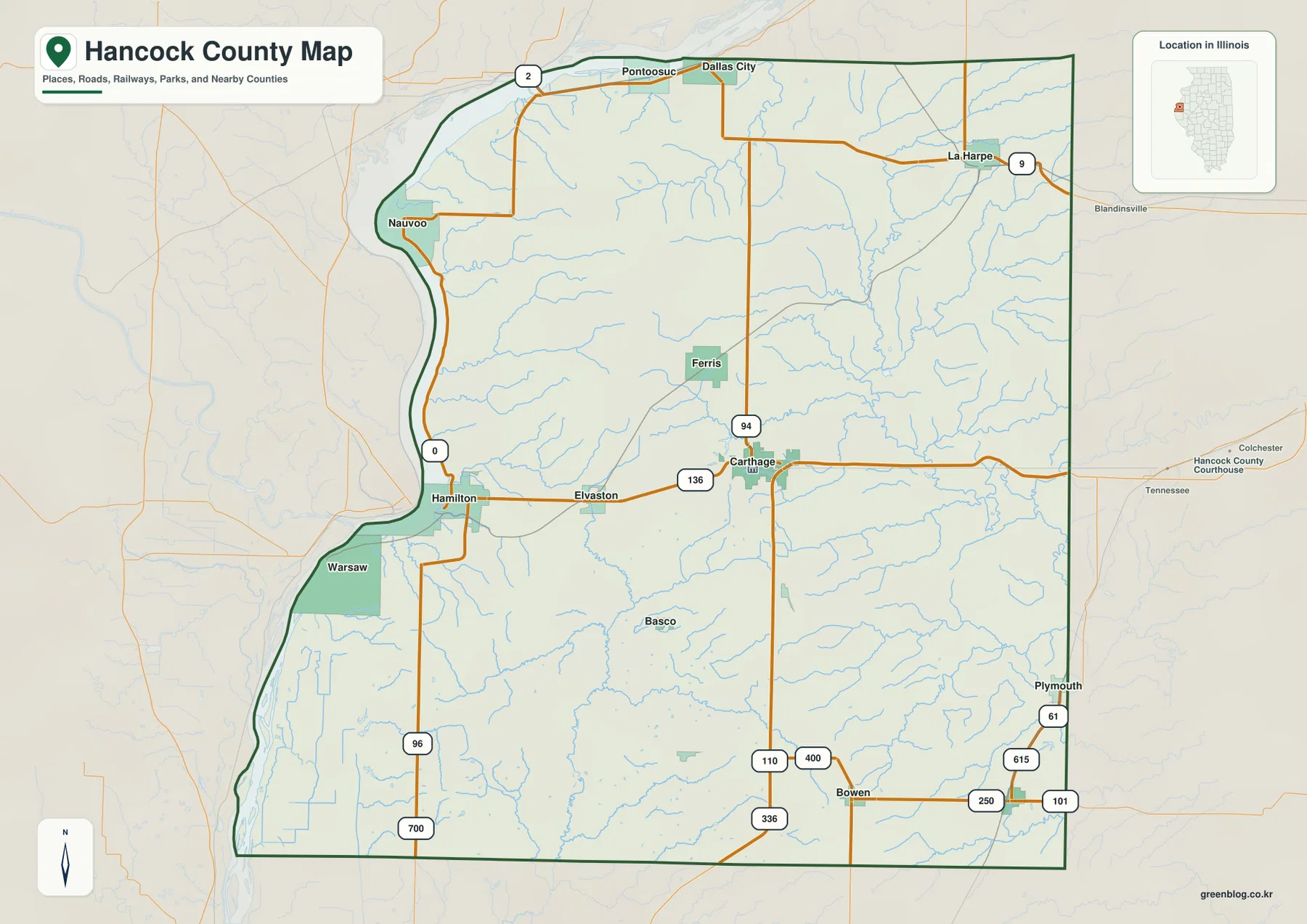
Hancock County covers a broad part of western Illinois rather than a single compact urban area. The general map shows Route 96 following much of the western side, Route 136 crossing from Hamilton through Carthage, Route 94 running north and south through the interior, and Route 9 reaching La Harpe in the northeast. South of Carthage, routes 110, 336, 250, 101 and 61 help orient the Bowen and Plymouth side of the county. On the water and elevation views, the broad Mississippi margin contrasts with the La Moine River system and its lower valleys in the east.
U.S. Census Bureau QuickFacts reports 793.75 square miles of land area and a 2020 census population of 17,620. Those numbers help explain why the mapped communities are separated by long stretches of rural land and creek country. These maps are designed for county-scale reference, classroom use, presentations and personal geographic study. They are not parcel maps, legal boundary surveys, flood maps or navigation products.
Table of Contents
A Mississippi River Edge and an Inland Road Hub at Carthage
The western boundary is the strongest shape on the county map. From the Dallas City and Pontoosuc area in the northwest, the line follows the Mississippi south toward Nauvoo, then curves past Hamilton and Warsaw before reaching a much wider lowland at the southwestern end of the county. The eastern boundary is comparatively straight, so the contrast is obvious even before road or city labels are read. For a first look at Hancock County, following the Mississippi from north to south is the simplest way to build a mental picture of the county.
Carthage sits near the middle of the county and is one of the best road anchors on the map. Route 136 approaches from Hamilton and Elvaston in the west, passes through Carthage, and continues toward McDonough County. Route 94 crosses the same area on a north-south line, connecting the interior with the Dallas City side to the north and the Route 110/336 corridor to the south. Hancock County’s courthouse and county offices are also in Carthage, so its central place on the map matches its administrative role.
The outer communities make the county’s spread easier to appreciate. La Harpe is well to the northeast near Route 9, while Bowen and Plymouth mark the southeastern and eastern edge. Warsaw occupies a lower Mississippi bend in the southwest, and Nauvoo lies farther north on another prominent river curve. Because these places are not tightly clustered, the road map is more useful when read as a set of connections between several small centers rather than as a street map of one continuous built-up area.
River Towns in the West, Interior Centers to the East
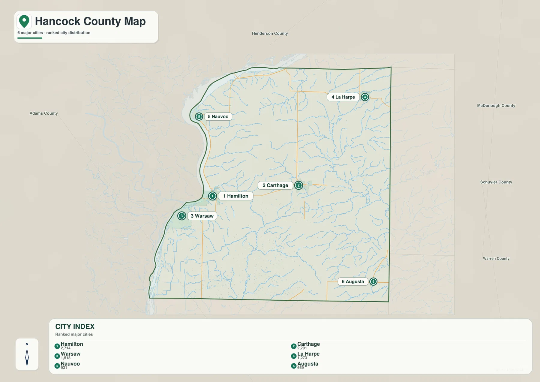
The city-distribution view removes much of the road detail and highlights six mapped communities. Its CITY INDEX ranks Hamilton first at 2,714 and Carthage second at 2,291, followed by Warsaw at 1,518, La Harpe at 1,273, Nauvoo at 931 and Augusta at 669. These are the values printed on the supplied map and are used here only to explain its ranking. They should not be treated as current official population estimates without checking a current Census source.
Geographically, three of the six points define the Mississippi side particularly well. Nauvoo sits on the northwest river bend, Hamilton appears farther south near the Route 136 crossing, and Warsaw is on the lower western section. Carthage provides an inland reference east of those river towns, while La Harpe reaches into the northeast and Augusta anchors the southeast. Seen together, the six points show that settlement is distributed across the full width of the county instead of following only the Mississippi corridor.
Nauvoo also has an official riverfront recreation context that reinforces what the map shows. The Illinois Department of Natural Resources describes Nauvoo State Park on the Mississippi River in Hancock County, on the south edge of Nauvoo along Illinois Route 96. The park covers 148 acres and includes a 13-acre lake. That information helps explain why Nauvoo is a useful west-side reference, although the county map itself is not a trail, camping or park-facility map.
Two Drainage Stories: the Mississippi Margin and the La Moine System
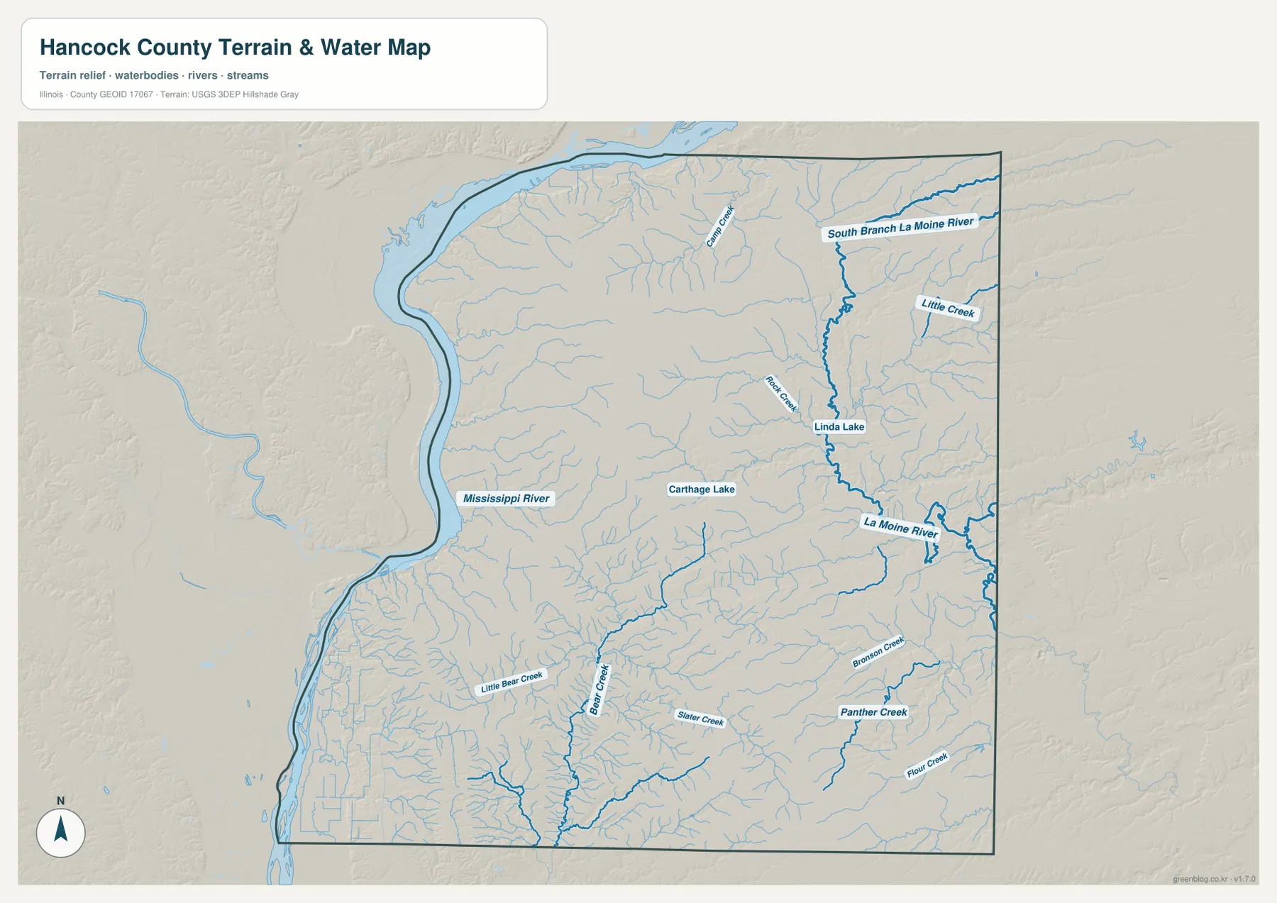
The terrain-and-water map divides the county into two broad hydrologic stories. Along the west, the Mississippi River is a wide blue boundary with a broad lowland beside it, especially toward the southwest. In the east, the South Branch La Moine River runs southward through a narrower valley and connects with the La Moine River. Between the two, dozens of small tributaries cut across the uplands. Starting with these large features makes the smaller creek network much easier to follow.
Carthage Lake provides a useful central landmark. Northeast of it, Rock Creek and Linda Lake appear near the South Branch La Moine River. Farther south, Bear Creek forms one of the stronger interior lines, with Little Bear Creek and Slater Creek nearby. The southeastern quarter contains named streams such as Panther Creek, Bronson Creek and Flour Creek. Rather than presenting the southern county as a blank agricultural block, the water view shows how many shallow valleys and tributaries divide that landscape.
This layer is a geographic reference, not a statement about flood risk or water access. It does not provide current river stage, flood probability, water quality, boat ramps, fishing rules or private-property boundaries. The USGS National Hydrography program is a better starting point when current source data are needed. A blue creek line on a county overview also should not be interpreted as proof of year-round flow at every location.
Relief from 107 to 230 Meters: Low River Ground and Interior Uplands
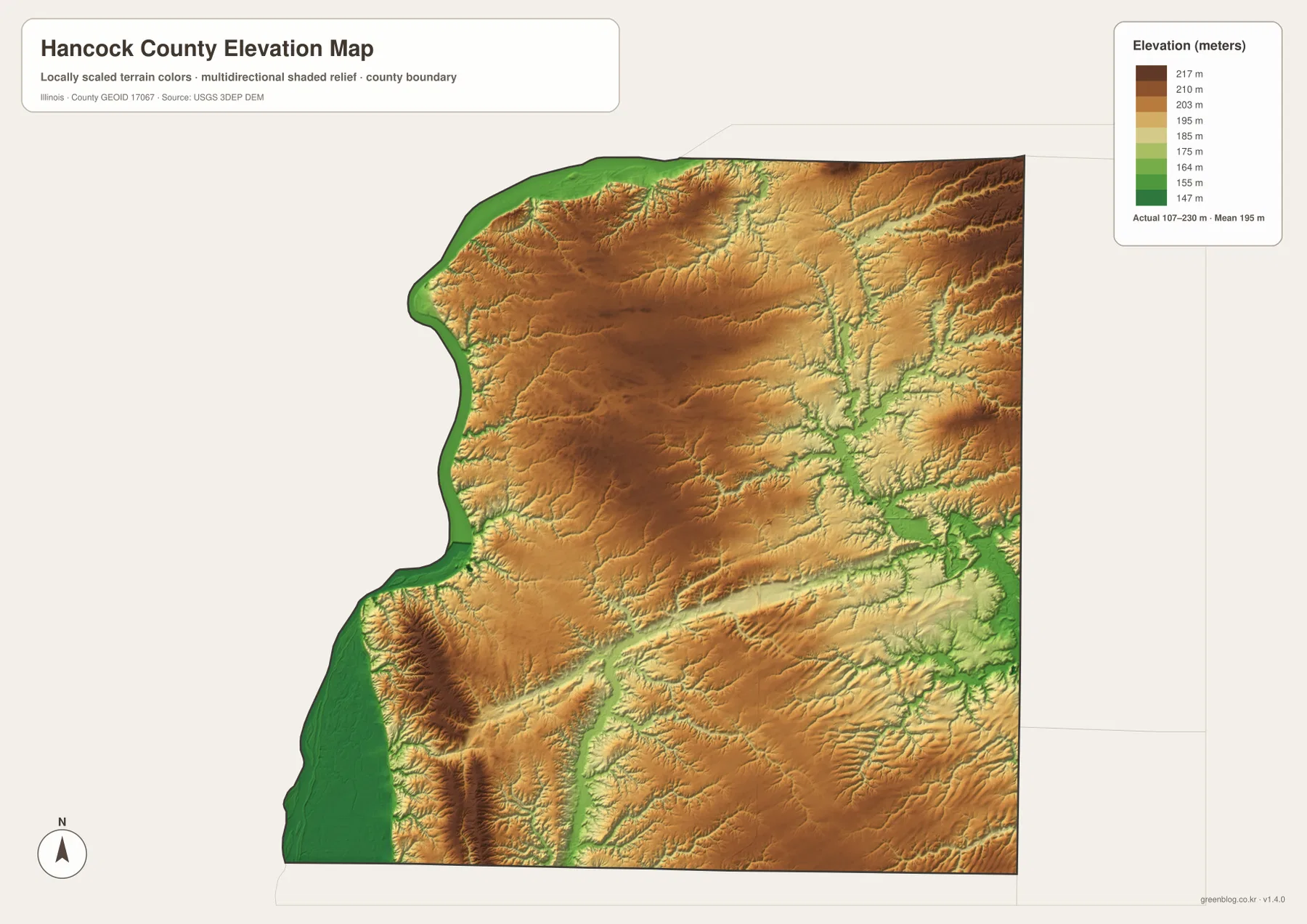
The elevation map reports an actual range of about 107 to 230 meters and a mean near 195 meters. The lowest green terrain follows the Mississippi edge, with the broadest low ground in the southwest and additional low strips beside the river farther north. This gives physical meaning to the county’s irregular western outline: the boundary is not merely a curved political line but the edge of a major river corridor with low floodplain terrain beside it.
Moving inland, tan and brown colors become dominant across the central and northwestern uplands. Some of the sharpest local relief lies just east of the Mississippi, where high bluffs and ridges rise close to low river ground. On the east side, green valleys associated with the La Moine River and its south branch cut through higher surrounding terrain. Smaller tributary valleys branch away from those channels, producing a much more textured surface than the road map alone suggests.
The elevation image is appropriate for broad comparison, not site engineering. It should not be used to set building elevations, calculate a road grade, establish a parcel boundary or determine whether a specific house is in a flood-prone location. For precise elevation work, the USGS 3D Elevation Program and professional survey information are the appropriate sources. Flood decisions require separate floodplain and river-stage information as well.
What Roads and Relief Explain When Viewed Together
Comparing the general map with the relief view helps explain why the county reads differently from west to east. Route 96 stays close to the Mississippi side and links Nauvoo, Hamilton and Warsaw, while Route 136 creates a cross-county connection from Hamilton through Carthage. Route 94 then provides a north-south interior reference, and Route 9 reaches La Harpe in the northeast. The roads simplify orientation, but the elevation layer shows that they cross ridges, creek valleys and low river margins rather than an entirely level plain.
Hamilton is especially useful as a bridge between the two ways of reading the county. It is close to the Mississippi and also sits on the Route 136 corridor leading directly toward Carthage. From Carthage, La Harpe lies to the northeast and Augusta to the southeast, while the western towns remain tied to the river. Using Hamilton and Carthage as paired anchors makes the county easier to follow than trying to memorize every smaller place name at once.
For current travel planning, the Illinois Department of Transportation highway maps are a useful companion. The map on this page emphasizes county-scale location and does not attempt to show work zones, closures, bridge restrictions or every local road. A practical workflow is to use the Hancock County map to understand which community lies in which direction, then confirm the actual route and current conditions with IDOT or a live navigation service.
Choosing the Best File for Boundaries, Towns, Water or Relief
Use the general county map when the main question is where a town sits, which route connects it, or how the Mississippi forms the western edge. It contains the broadest mix of place names and numbered roads. The ranked-city view is cleaner when the task is to compare Hamilton, Carthage, Warsaw, La Harpe, Nauvoo and Augusta without the distraction of many minor labels. It is especially helpful for seeing the west-to-east spread of the six highlighted communities.
Choose the terrain-and-water map when the Mississippi River, La Moine River, South Branch La Moine River, Bear Creek or the smaller named streams matter more than roads. The elevation file is the better choice when low river ground, interior uplands and the eastern valleys need to be compared. For a presentation, one effective sequence is to introduce the county with the general map, then use either the water or elevation view to explain why the landscape changes between the river and the interior.
The WebP images in the article are optimized for browser viewing. The ZIP contains the original JPG versions at 3638 × 2572 pixels, which are more useful for enlarging small labels or preparing an A3 print. The archive includes the general county map, ranked city map, terrain-and-water map and elevation map. It does not include GIS layers, an editable vector package or the source elevation model.
Frequently Asked Questions
Why does the western county boundary bend so sharply?
The supplied county and water maps show the boundary following the Mississippi River. As the river bends past the Dallas City area, Nauvoo, Hamilton and Warsaw, the county line bends with it. That makes the west side very different from the straighter eastern border. Use current Census TIGER/Line or county records if a legally precise boundary is required.
Are the CITY INDEX values current official population totals?
No. This article treats 2,714 for Hamilton, 2,291 for Carthage, 1,518 for Warsaw, 1,273 for La Harpe, 931 for Nauvoo and 669 for Augusta as the ranking values printed on the supplied city map. Current official population information should be checked separately with the U.S. Census Bureau.
Can the 107–230 meter elevation map be used for surveying or flood decisions?
No. It is a generalized county-scale relief view intended to compare the Mississippi lowlands, interior uplands and La Moine valleys. It does not provide survey-grade spot elevations or flood probabilities. Use original USGS elevation data for precise heights and the appropriate floodplain authority for property-level flood decisions.
Map File Information
The ZIP contains the Hancock County road-and-boundary map, ranked city map, terrain-and-water map, and elevation map as original high-resolution JPG files.
- Included Files: 4 JPG maps
- Printable Size: 3638 × 2572 pixels each
- Intended Use: Printing, education, presentations, and county-scale geographic reference
Related Maps
Sources and Reference Data
- Hancock County, Illinois official website – county government and local overview
- U.S. Census Bureau QuickFacts – Hancock County, Illinois – land area and population reference
- Illinois DNR – Nauvoo State Park – official Mississippi River and Nauvoo recreation context
- Illinois Department of Transportation – Highway Maps – official current road-map resources
- USGS National Hydrography – source reference for rivers and streams
- USGS 3D Elevation Program – source reference for elevation data
Green Map creates custom-edited map images using open geographic data sources such as geoBoundaries, Natural Earth, OpenStreetMap, and government open data.
These maps are edited visual materials, not raw data files, and are provided for education, documents, presentations, and graphic reference.