Issaquena County is a place where the shape of the Mississippi River matters more on a map than a dense network of cities. Mayersville sits near the river in the northwestern part of the county, while long stretches of the interior contain roads, bayous, lakes, and low floodplain terrain with very few large settlement labels. This page uses the county, city, water, and elevation maps together so the western river bends, the eastern road connections, and the county’s very low relief can be understood as one landscape. A ZIP containing the four high-resolution A3 JPG map files is also available for download below.
The four views answer different practical questions without turning the page into a map inventory. The county map is best for Mayersville, state highways, US 61, and the irregular county outline. The city map makes the sparse settlement pattern obvious because Mayersville is the only major city label in its index. The water map adds Steele Bayou, the Yazoo River, the Little Sunflower River, and numerous lakes, while the elevation map shows that most of the county lies within a narrow band of roughly 20 to 41 meters above sea level.
Table of Contents
Mayersville, the road network, and a boundary shaped by the river
Mayersville is the clearest place anchor on the general county map. MS 14 runs east from the Mayersville area toward the Rolling Fork side of the map, while MS 16 appears farther north near Grace. MS 1 crosses the central part of the county, MS 465 is marked near a large southwestern river bend, and US 61 follows the eastern side near Valley Park. These routes are not packed into a compact urban grid. Instead, they are separated by broad tracts of low land and by waterways that make the county feel much larger on the ground than a simple road list suggests.
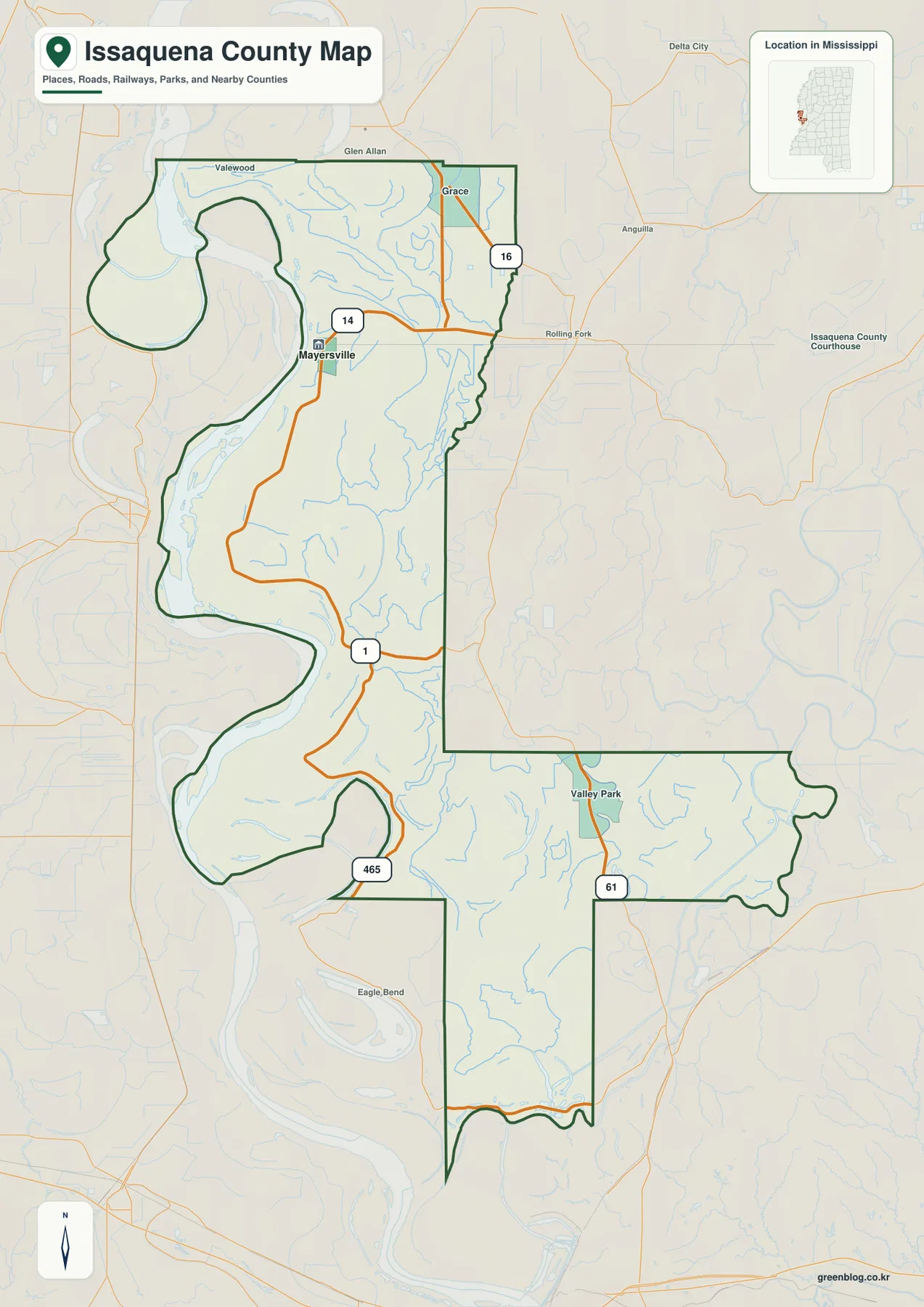
The western edge is especially distinctive. Rather than following a straight line, the county boundary repeatedly curves around large bends of the Mississippi River. Broad loops appear in the northwest, west-central area, and southwest, giving the county a deeply indented outline. The eastern side is straighter for longer distances but also includes a large inward step before the county extends east again around Valley Park. For anyone comparing Issaquena with neighboring Delta counties, the outline itself is one of the most useful identifying features.
A city map with one major place: Mayersville
The city index is unusually simple: Mayersville is the single major city shown. That makes this map less useful for ranking several towns and more useful for seeing how little of the county is organized around a large urban center. Mayersville occupies a northwestern position near the Mississippi River side, while the long southern section and the eastern extension have no comparable city marker. The empty space is meaningful because it matches the county’s very small population spread across more than 400 square miles of land.
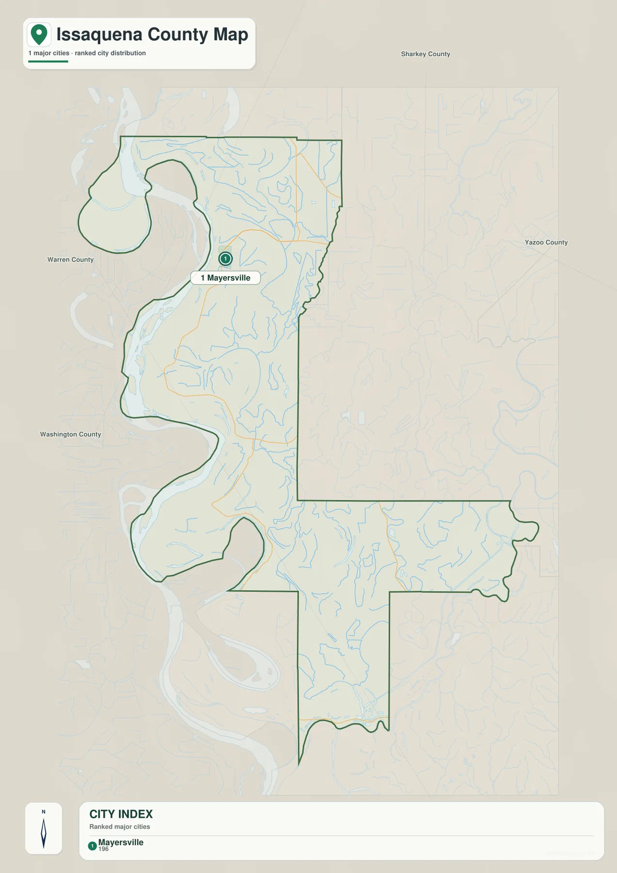
The 2020 census counted 1,338 residents, and the July 2025 estimate shown in the source material is 1,263. The 2025 Gazetteer lists 412.980 square miles of land and 28.442 square miles of water. Those figures help explain why a city-focused reading does not work well here: the county is geographically broad but lightly settled. They should not be read as if residents were evenly spaced from the river to the eastern boundary. The maps instead show a small number of named places connected by a few important roads through a landscape dominated by water and low ground.
| Item | Map or source value |
|---|---|
| County seat | Mayersville |
| FIPS | 28055 |
| 2020 census population | 1,338 |
| July 2025 population estimate | 1,263 |
| Land area | 412.980 sq mi |
| Water area | 28.442 sq mi |
| Elevation range | about 20–41 m |
| Mean elevation | about 29 m |
Bayous, lakes, and river channels across the floodplain
The terrain-and-water map contains far more named features than the city map. The Mississippi River defines the western setting, while Steele Bayou and East Prong Steele Bayou run through the northern interior. Newsome Bayou appears farther south, and the southeastern portion adds Cypress Bayou and the Yazoo River. The eastern projection contains the Little Sunflower River and Deer Creek. Together, these labels show that water does not occur only along the outer river boundary; channels and tributaries also cross the county from north to south and east to west.
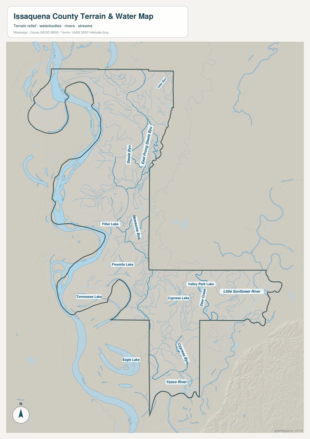
Several lakes provide additional location references. Fitler Lake and Fivemile Lake are marked in the northern half, Tennessee Lake lies farther southwest, and Valley Park Lake and Cypress Lake appear toward the eastern extension. Eagle Lake is labeled in the southern part near another broad Mississippi River bend. Because many of these water bodies occupy former channels or low parts of the floodplain, the water map is particularly useful when a road map alone does not explain why two nearby-looking places are separated by a long route.
This network also changes how directions should be described. Saying that a point lies west or east of Mayersville is only a first step. A more useful description often includes whether the location is on the Mississippi River side, near Steele Bayou, toward the US 61 corridor, or close to the Yazoo River. On a county with so few large settlements, rivers and bayous become practical landmarks for understanding position.
What a 20–41 meter elevation range looks like on the map
The elevation map gives an actual range of about 20 to 41 meters and a mean near 29 meters. That is a small vertical range compared with hillier Mississippi counties, yet the shaded relief still reveals meaningful differences. Lower green areas follow parts of the western river margin and extend through southern lowlands, while tan and brown tones mark slightly higher surfaces in the northwest and parts of the interior. The point is not to find a mountain or a dramatic ridge; it is to see subtle height changes within an otherwise low Delta landscape.
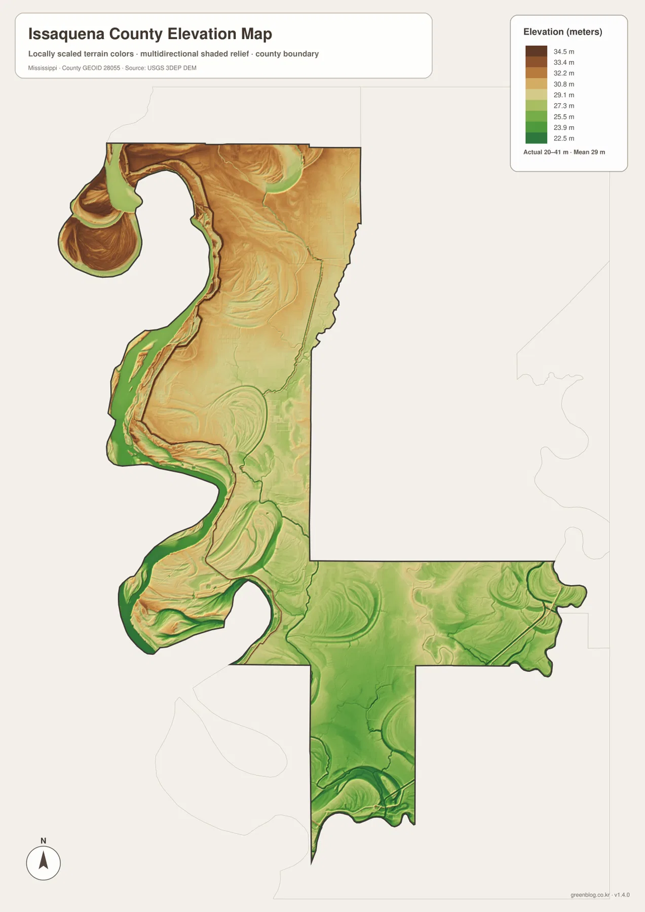
The western bends are especially useful for comparison because the river edge, low green corridors, and slightly higher tan surfaces sit close together. Similar subtle changes continue through the southern half and the eastern projection. When the elevation map is viewed beside the water map, the low corridors line up with many of the channels and former river features, making the terrain easier to understand than it would be from elevation numbers alone.
Choosing the most useful map for your task
Use the general county map first when you need Mayersville, MS 14, MS 1, US 61, or the unusual outer boundary. The city map is the fastest way to show that Mayersville is the only major city in the index. For named water features, the terrain-and-water map adds far more detail than the road map, including Steele Bayou, the Yazoo River, the Little Sunflower River, Eagle Lake, and other lakes. The elevation map is best when the question is not “where is the road?” but “which parts of this very flat county are slightly lower or higher?”
- Roads and boundary: use the county map for Mayersville, MS 14, MS 1, US 61, and the Mississippi River-shaped western edge.
- Settlement pattern: use the city map to show how Mayersville stands apart in a county with no other major city marker.
- Water features: use the water map for Steele Bayou, the Yazoo River, the Little Sunflower River, Deer Creek, and named lakes.
- Relief: use the elevation map to compare the 20–41 meter range and the low corridors near major waterways.
The WebP images on the page are intended for quick viewing, while the downloadable files are better suited to printing, presentation layouts, and editing. The ZIP below contains the same four map subjects as high-resolution A3 JPG files, so you do not need to save the page previews one at a time.
Frequently Asked Questions
Why does the city map show only Mayersville as a major city?
The supplied city index identifies Mayersville as the single major city in Issaquena County. That makes the map useful for showing how sparse the settlement pattern is rather than for comparing a group of similarly sized towns.
Is the elevation map useful when the county is only about 20–41 meters high?
Yes. The total range is small, but the shaded relief separates river-edge lowlands from slightly higher interior surfaces. Paired with the water map, it helps explain why many channels and lakes occupy particular low corridors.
Which map is best for Steele Bayou, Eagle Lake, and the Yazoo River?
Use the terrain-and-water map. It labels those features along with East Prong Steele Bayou, Newsome Bayou, the Little Sunflower River, Deer Creek, Cypress Bayou, and several additional lakes that are not emphasized on the general road map.
Map File Information
Download the high-resolution A3 JPG files for the Issaquena County general map, city map, water map, and elevation map in one ZIP archive.
- Included Files: county map, city map, water map, elevation map
Related Maps
Sources and References
- U.S. Census Bureau QuickFacts for Issaquena County — population reference
- U.S. Census Bureau Gazetteer Files — land and water area reference
- Mississippi Department of Transportation official highway map — road reference
- USGS National Hydrography — rivers, bayous, creeks, and lakes
- USGS 3D Elevation Program — elevation reference
- Mississippi Encyclopedia: Delta — regional landscape context
Green Map creates custom-edited map images using open geographic data sources such as geoBoundaries, Natural Earth, OpenStreetMap, and government open data. These maps are edited visual materials, not raw data files, and are provided for education, documents, presentations, and graphic reference.