This Kendall County Illinois Map page lets you download four high-resolution JPG maps directly in one ZIP, while the WebP versions on the page provide a quick view of roads, communities, waterways, and elevation. Yorkville anchors the north-central part of the county, Oswego and Montgomery sit farther east and northeast, and Plano extends the main settlement band westward. Newark and Lisbon are more widely separated in the south and southwest, where the road and stream pattern becomes less urban and more open.
The Fox River is the clearest natural reference for understanding these places together. It crosses the northern part of Kendall County near Yorkville and Oswego and receives tributaries such as Blackberry Creek, Rob Roy Creek, Little Rock Creek, and Big Rock Creek. South of the main river corridor, the Middle, East, and West Aux Sable Creek branches form another network through the interior. Comparing the water and elevation maps shows why many of these stream corridors appear as lower ground between gently higher uplands.
The supplied maps are designed for different kinds of questions rather than as simple color variations. The general county map combines boundaries, roads, settlements, and selected public facilities. The city map makes six ranked communities easy to compare without road clutter, the terrain-and-water map emphasizes the Fox River and tributaries, and the elevation map shows an actual local range of about 147 to 248 meters. Together they provide a practical county-scale reference for location, waterways, and relief without turning the page into a technical GIS report.
Table of Contents
Roads and communities from Yorkville to Oswego and Plano
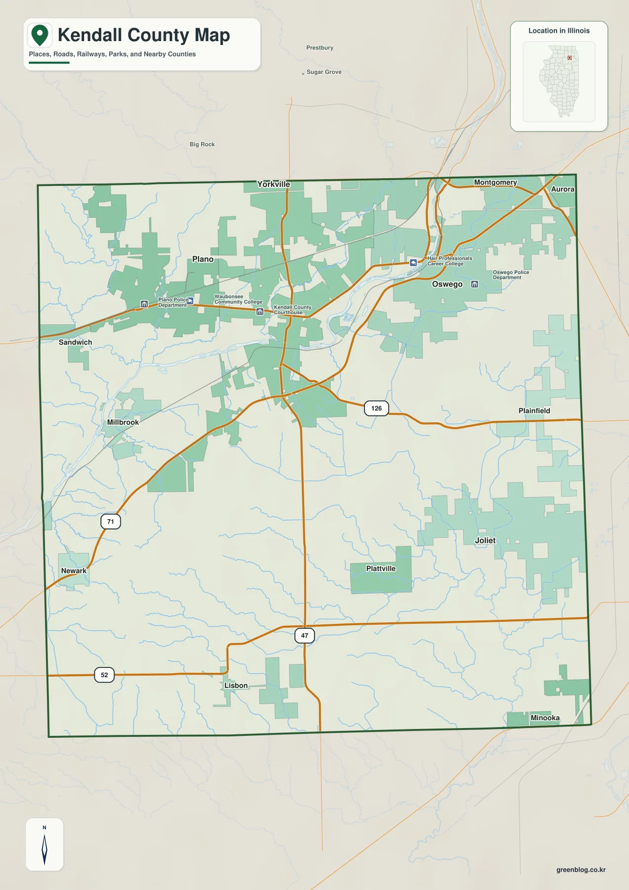
The northern part of the general map contains the county’s most closely spaced communities. Yorkville is near the center of that cluster, Oswego lies to the east, and Montgomery is close to the northern edge. Plano is farther west, creating a broad east-west chain of named places across the upper part of the county. The Kendall County Courthouse is marked near Yorkville, while police and college-related points appear around Plano and Oswego. These labels make the map useful for orientation because the civic markers reinforce where the main communities sit.
Route 47 provides the clearest north-south road reference. It passes through the Yorkville area and continues toward the southern boundary, making it useful when locating the interior between the northern communities and the smaller southern settlements. Route 71 angles toward Newark in the southwest. Route 126 runs across the east-central part of the map, and Route 52 crosses the southern side. Even without every local street name, these numbered roads are enough to establish the county’s major directions.
Several names near the frame belong to surrounding areas rather than the county interior. Aurora appears near the northeast, Sandwich is shown to the west, and Plainfield and Joliet are visible east of the boundary. They work as orientation points for readers who already know northeastern Illinois. The map should not be read as if every nearby label falls within Kendall County; the dark county outline is the better guide when distinguishing the subject area from neighboring communities.
South of the main northern group, settlement spacing changes noticeably. Newark is placed in the southwest, Lisbon is near the south-central area, and Minooka is close to the southeastern edge. Roads still cross the county, but the map contains fewer large community labels and fewer facility markers than it does around Yorkville and Oswego. That contrast is useful for describing the county without reducing the southern half to empty space: small communities, local roads, and numerous streams remain important features even where the urban footprint is lighter.
This is a county-orientation map rather than a turn-by-turn navigation product. It works well for seeing where the communities sit in relation to one another, which numbered routes cross the county, and where the county boundary falls. Current construction, closures, travel times, and exact street-level directions should be checked with a current transportation service. For a classroom handout, regional overview, or quick location reference, the simpler county-scale view is often more useful than a street map.
Six ranked communities show a strong northern concentration
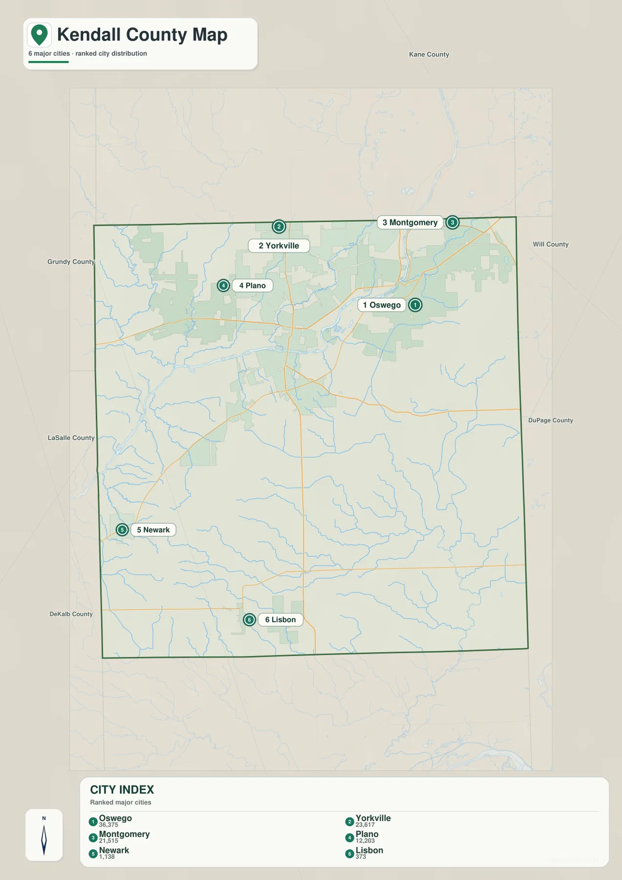
The city-distribution map removes much of the road detail and leaves six prominent numbered locations. Oswego is ranked first and sits in the northeast. Yorkville is second and lies west of Oswego, while Montgomery is third near the northern edge. Plano is fourth and farther west. Newark and Lisbon, ranked fifth and sixth, anchor the southwest and southern portions of the map. The arrangement makes the county’s settlement pattern clear at a glance: the larger named places are concentrated across the north, with smaller places farther south.
The CITY INDEX printed on the map lists 36,375 for Oswego, 23,617 for Yorkville, and 21,515 for Montgomery. Plano is shown with 12,203, followed by Newark at 1,138 and Lisbon at 373. These are the reference values embedded in the supplied map, not a substitute for a current official population table. Population estimates and municipal boundaries can change, so anyone needing the latest counts should check the Census Bureau or the relevant local government.
Oswego, Yorkville, and Montgomery sit close enough together that they form the most visually concentrated group on the map. Returning to the general road map after seeing this simplified version helps explain why the northern area contains more road and facility detail. Plano extends the northern settlement band to the west. Newark and Lisbon, by contrast, provide useful anchors for the broader southern interior, where named places are more widely separated.
The edge labels also place Kendall County among its neighbors. Kane County is to the north, Will and DuPage are shown to the east, while Grundy, LaSalle, and DeKalb appear around the remaining sides. The purpose is regional orientation, not a legal boundary survey. Those neighboring labels are especially helpful for readers who know the Chicago-area counties but are less familiar with Kendall County itself.
The city map does not provide driving distance or travel time between the numbered points. The spacing is geographic, so a straight visual comparison should not be treated as a route measurement. If the goal is simply to explain where the main communities are concentrated, however, this stripped-down view is faster to read than the full road map. It also works well before switching to the water or elevation maps, because the six locations give the reader a stable set of reference points.
The Fox River and two different tributary networks
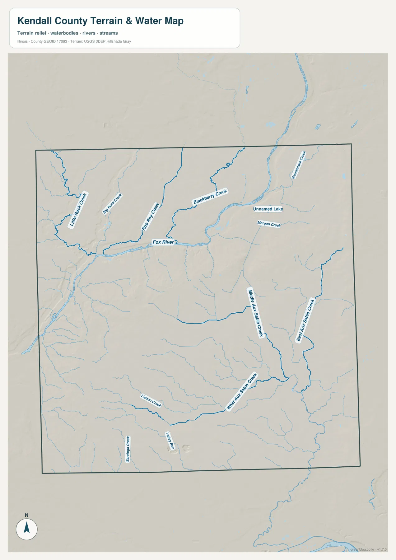
The Fox River is the dominant water feature on the terrain-and-water map. It crosses the northern part of the county and gathers several smaller streams before continuing beyond the mapped area. When the river is compared with the general map, its relationship to Yorkville and Oswego becomes much easier to understand. The northern communities are not simply connected by roads; they also sit close to a major river corridor that creates a distinct low valley through the surrounding terrain.
Several named tributaries approach the Fox River from the north and northwest. Little Rock Creek and Big Rock Creek appear on the western side, Rob Roy Creek runs toward the main river, and Blackberry Creek crosses the north-central area. Waubonsie Creek and Morgan Creek are labeled farther east. Rather than memorizing every stream, it is more useful to notice the overall arrangement: smaller drainage lines converge toward the main river and break the uplands into a series of shallow valleys.
The southern part of the map has a different emphasis. Middle Aux Sable Creek, East Aux Sable Creek, and West Aux Sable Creek occupy the south and southeast, while Lisbon Creek and Valley Run are also labeled in the interior. These streams help explain why the lower half of the county is not a single flat surface even though the road map looks relatively open. Small valleys continue across the rural interior and become more obvious when road symbols are removed.
A few small water bodies are also drawn, including an unnamed lake. They are useful orientation features but should not be interpreted as current flood boundaries, legal wetland limits, water-quality conditions, or navigation information. This map is designed to show the county-scale relationship between terrain and water. Flood planning, engineering, and real-time river conditions require dedicated government sources created for those purposes.
For local context beyond the county-scale image, the Kendall County Forest Preserve District publishes official preserve maps and amenity information. Those materials include sites around Yorkville, Plano, Millbrook, and other parts of the county, and they can be useful when a reader wants to move from a broad river-and-stream overview to a specific public preserve. The map on this page should still be treated as a general county reference rather than a trail map.
Elevation from about 147 to 248 meters follows the valleys
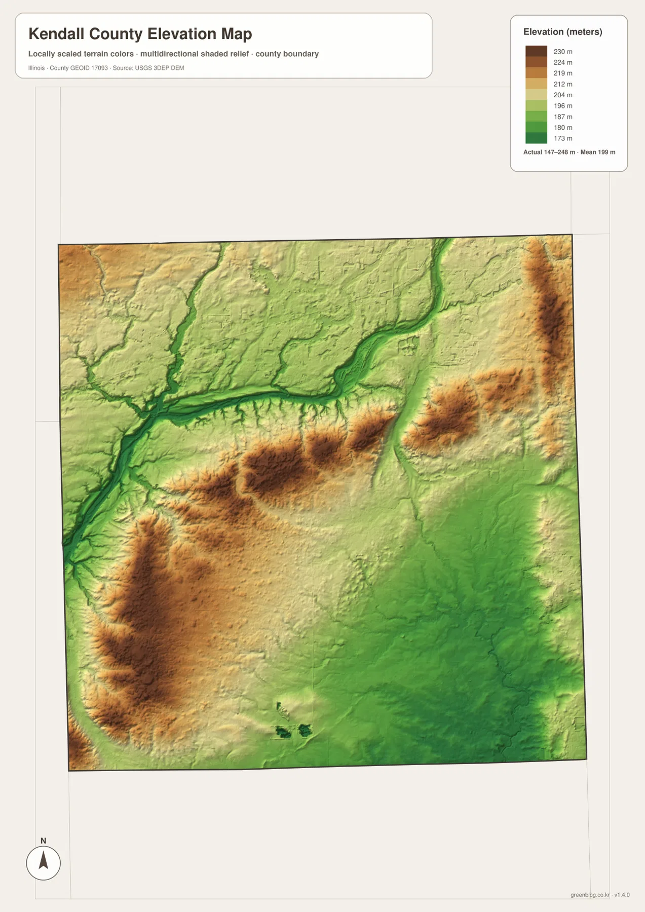
The elevation legend shows an actual range of about 147 to 248 meters and a mean near 199 meters. Kendall County is not mountainous, but the local relief is still easy to see. The Fox River corridor forms a long green lowland, and several tributary valleys branch away from it. Yellow, tan, and brown areas rise on the neighboring uplands, producing a more varied surface than the general road map suggests.
The lowest-looking corridor aligns closely with the Fox River seen on the water map. Narrow green lines also extend into tributaries such as Blackberry Creek and Rob Roy Creek. This comparison is important because an elevation image by itself can look like a collection of colors. Once the river network is known, the green bands make geographic sense as lower valleys cut into the surrounding terrain.
Higher ground appears in several separate patches rather than as one continuous ridge. Uplands rise west and south of the main river corridor, and additional higher terrain is visible farther east. The county therefore should not be summarized with a simple statement such as “north is low and south is high.” The better description is that river and creek valleys form lower pathways between gently higher pieces of interior terrain.
The Aux Sable Creek system helps explain the southern half of the elevation image. Low lines follow portions of the drainage network, with moderately higher ground between them. When Newark and Lisbon are located on the general map and then compared with this surface, it becomes clear that the southern interior has subtle relief even though its roads and settlements are less dense than those in the north.
This elevation image is a county-scale visualization, not a survey or engineering product. The 147–248 meter range is useful for comparing the broad landscape, but it should not be used to determine the exact elevation of a building lot, design drainage, or set construction grades. Detailed work should rely on the original USGS elevation data, project-specific measurements, or a professional survey.
Choosing the right Kendall County map for the task
For a first look at the county, begin with the general map. Find Yorkville, Oswego, Plano, and Montgomery, then use Routes 47, 71, 126, and 52 to establish the main directions. Newark and Lisbon provide references for the southern half. Nearby labels such as Aurora, Sandwich, Plainfield, and Joliet can then be used to understand how the county sits within the larger region without confusing those places with the county interior.
Use the city-distribution map when the question is where the largest mapped communities are concentrated. Its six numbered markers make the concentration of larger communities toward the north obvious. Use the terrain-and-water map when the Fox River and tributaries matter more than road names. After locating the main river, the smaller creeks can be traced into the surrounding uplands without the visual clutter of facility symbols.
The elevation map works best after the waterways are familiar. Compare the green Fox River valley with the tan and brown uplands on either side, then look for narrower low lines where tributaries cut through the interior. That sequence turns the elevation colors into a readable landscape instead of an abstract surface. It is especially useful for a school project, regional overview, or general geographic explanation.
The WebP images on this page are optimized for convenient on-screen viewing. If you need to zoom into road labels and stream names or print the maps at a larger size, the ZIP below contains the original high-resolution JPG versions. It includes the general county map, ranked-city map, terrain-and-water map, and elevation map shown in the article.
Frequently Asked Questions
Which map is best for locating Yorkville, Oswego, Plano, and Montgomery?
The general county map is the best starting point because it shows those communities together with the main roads and selected public facilities. The ranked city map is simpler if you only need their relative positions and size order. Looking at both makes it easy to move from a clean settlement overview to the actual road network.
Where can I see the Fox River and the Aux Sable Creek branches?
Use the terrain-and-water map. It labels the Fox River along with northern tributaries such as Blackberry Creek and Rob Roy Creek, while Middle, East, and West Aux Sable Creek appear in the southern part of the county. The elevation map is useful afterward because it shows the lower valleys associated with many of those waterways.
Can the 147–248 meter elevation range be used for surveying or construction?
No. The elevation map is a generalized county-scale reference intended to compare low river valleys with higher surrounding terrain. Exact site elevations for engineering, drainage, or construction should come from appropriate USGS source data, project-specific measurements, or a professional survey.
Map File Information
The original high-resolution JPG files for Kendall County are bundled into one ZIP. The set covers the county boundary and roads, ranked communities, the Fox River and tributaries, and elevation and terrain.
- Included Files: 4 high-resolution JPG images
- File Type: ZIP archive containing JPG images
Related Maps
Sources and references
- U.S. Census Bureau TIGER/Line Shapefiles – official source for county boundaries, roads, and other geographic features.
- USGS National Hydrography – official hydrography information for rivers, streams, and surface-water features.
- USGS 3D Elevation Program – official USGS source for elevation data and terrain products.
- Kendall County, Illinois – official county government website.
- Kendall County Forest Preserve Maps and Amenities – official local maps and information for county forest preserves.
Green Map creates custom-edited map images using open geographic data sources such as geoBoundaries, Natural Earth, OpenStreetMap, and government open data.
These maps are edited visual materials, not raw data files, and are provided for education, documents, presentations, and graphic reference.