Chatham County lies in North Carolina’s central Piedmont, but it does not read like a county with one obvious urban center. Siler City is a major western reference, Pittsboro is the county seat farther east, and B. Everett Jordan Lake takes over much of the eastern landscape with a long, branching shoreline. South of those places, Goldston, Moncure, the Rocky River, and the Deep River provide a different set of landmarks. The maps supplied with this page are designed to show those relationships from three useful angles: a general county view, a simplified city view, and a terrain-and-water view. Larger A3 JPG versions of all three are available in the download box farther down the page.
A good way to get oriented is to follow U.S. 64 from Siler City toward Pittsboro. U.S. 421 gives Siler City a strong north-south reference, while U.S. 15-501 and NC 87 form an important north-south corridor around Pittsboro. U.S. 1 appears near Moncure in the southeast, and NC 751 helps frame the northeastern side near the Jordan Lake area. That road pattern makes the west-to-center relationship easy to see. The water map then adds the other half of the county’s geography: the Haw River entering from the north, Jordan Lake spreading across the east, the Rocky River crossing the south, and the Deep River following the lower edge.
Table of Contents
U.S. 64 links Siler City and Pittsboro across a broad interior
The general county map makes U.S. 64 the clearest east-west guide. Siler City occupies the western side of Chatham County, with Chatham Hospital labeled nearby, while Pittsboro sits east of center where several major roads meet. Between the two towns, the map shows a wide area with many streams and fewer large place labels. That spacing is important. It prevents the county from looking like a continuous urban corridor and helps explain why Siler City and Pittsboro work better as separate reference points than as parts of one dense city cluster.
Roads divide the county into several practical orientation zones. U.S. 421 passes the Siler City side and continues toward the northern and southern edges. NC 902 crosses the southwestern portion near Goldston and Bennett. Pittsboro is more connected in multiple directions, with U.S. 64 running east-west and U.S. 15-501 and NC 87 extending north and south. Northeast of town, Fearrington Village and Briar Chapel appear as additional place references. Farther east, the map places Apex and Cary outside the county boundary, which helps show how the northeastern edge relates to the Triangle even though the page itself remains focused on Chatham County.
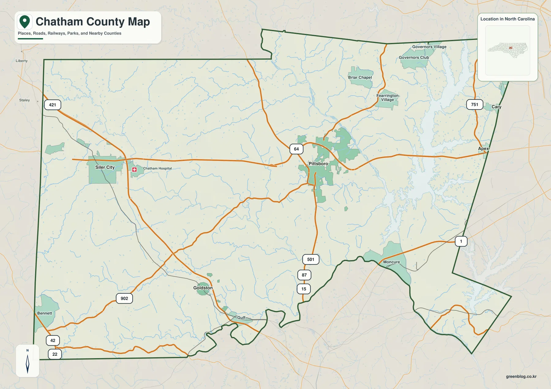
The southeastern corner changes character again. Moncure is labeled near U.S. 1, separated from the western towns by a large area with fewer urban labels. The county boundary also becomes more irregular as it approaches major water features. In the southwest, Bennett and Goldston provide quieter location markers where the road network is less concentrated than it is around Pittsboro. This mix of a western town center, an administrative center near the middle-east, and a water-dominated eastern side is the main reason a single “downtown-to-edge” description does not fit Chatham County very well.
The city map makes the separation between Siler City and Pittsboro obvious
The city map removes most of the road detail and highlights three places: Siler City, Pittsboro, and Goldston. Siler City is used as the hub. Pittsboro is shown about 16 miles away by direct distance, while Goldston is about 12 miles away. Those figures are straight-line map distances, not driving mileage, but they are useful for showing the basic layout. Pittsboro is well east of Siler City, and Goldston is clearly south and slightly east of the western hub. The simplified view makes that geometry much easier to grasp than a busier road map.
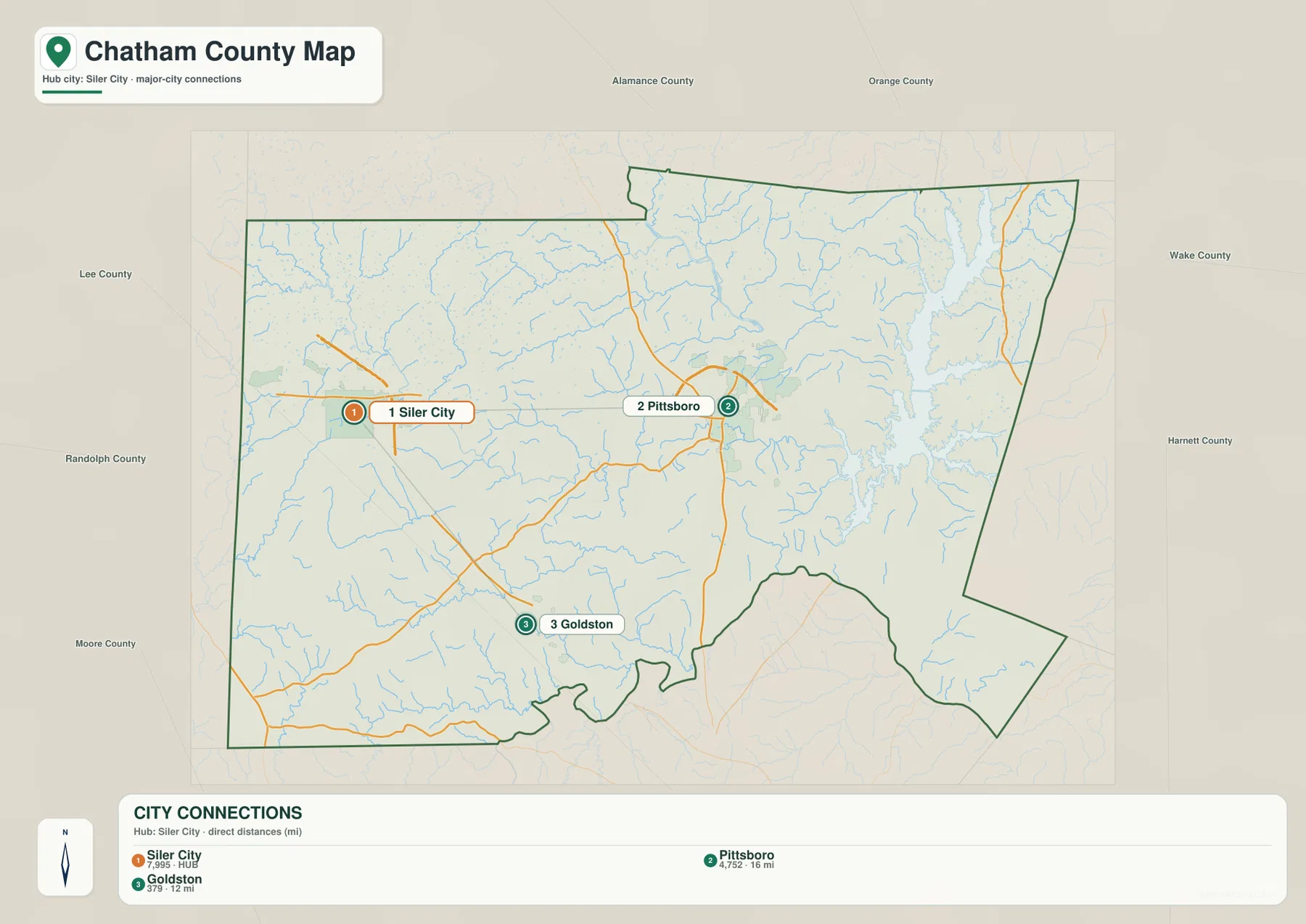
Neighboring county labels add useful context around that simple triangle. Alamance and Orange Counties are shown to the north, Wake and Harnett to the east, Lee and Moore toward the south and southwest, and Randolph to the west. These labels help a reader understand which Chatham communities sit closest to particular sides of the county. Siler City is the obvious western reference near the Randolph side. Pittsboro is farther east and more central to routes leading toward the northeastern and southeastern portions. Goldston sits lower in the county and is a better reference for the Deep River and Lee County side.
Chatham County’s official community page identifies Pittsboro as the county seat and lists Siler City and Goldston among the county’s incorporated towns. That helps explain why the maps appear to emphasize more than one center. Pittsboro is the administrative anchor, but Siler City remains a prominent western population and road reference. The city map is especially useful when the goal is not to trace every highway but to explain why a place in western Chatham can be much closer to Siler City than to Pittsboro, or why Goldston belongs to a more southerly part of the county.
Jordan Lake and the Haw, Rocky, and Deep Rivers reshape the eastern and southern map
The terrain-and-water map shifts attention away from highways and toward the drainage network. B. Everett Jordan Lake is the largest feature on the eastern side, with long narrow arms extending into the county. The Haw River enters from the north and continues toward the reservoir, while Terrell Creek and Dry Creek are labeled in the northern interior. Once the road symbols are removed, it becomes much easier to see that eastern Chatham is organized around a major reservoir and a dense collection of smaller waterways rather than around a continuous line of towns.
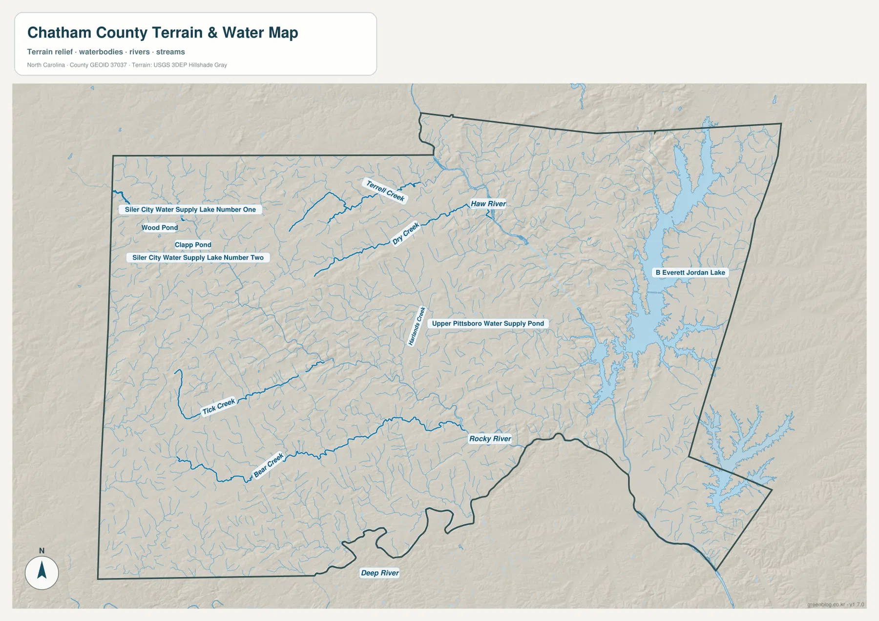
The western side has its own smaller water features. Near Siler City, the map labels Siler City Water Supply Lake Number One and Number Two along with Wood Pond and Clapp Pond. Tick Creek and Bear Creek appear farther south and east. Across the lower part of the county, the Rocky River becomes a much stronger visual feature, and the Deep River is labeled along the southern boundary. Chatham County’s own community information also identifies Jordan Lake, the Rocky River, the Haw River, and the Deep River as important waters, so the major names on the map match the county’s broader description of its natural setting.
Near Pittsboro, Upper Pittsboro Water Supply Pond is labeled among a network of smaller tributaries. The shaded relief underneath the blue drainage lines suggests the rolling ridges and shallow valleys typical of the Piedmont rather than a flat plain. This map is useful for seeing where water lies and how the terrain changes around it, but it is not a substitute for an engineering elevation model, a flood map, or a property survey. The package does not include a separate elevation map, so exact elevations and slopes should be checked against official elevation data when those measurements matter.
Jordan Lake deserves special attention because it is not simply a decorative feature on the eastern edge. Chatham County describes the lake as a major recreational lake and water reservoir, and the county also notes that the Haw and Deep Rivers converge to form the Cape Fear River. Those facts help explain why the southeastern part of the county contains so many connected water references. A reader looking only at Pittsboro and Siler City would miss this major part of Chatham’s geography, while the terrain-and-water view makes the relationship clear without requiring a specialized hydrology map.
Moncure is the key reference for Chatham County’s southeastern corner
Moncure appears near U.S. 1 in the southeast and provides a useful place name for an area that otherwise contains large stretches of water and rural land. On the general map, the community sits well away from Siler City and south of Pittsboro. On the water map, the same area is close to the southern reach of the Jordan Lake system and to the broader Haw-Deep river setting. Switching between those two views shows why the southeast should not be described merely as “below Pittsboro.” Its roads, river relationships, and distance from the western center give it a distinct position within the county.
The northeastern side offers another useful comparison. Fearrington Village and Briar Chapel are labeled north and northeast of Pittsboro, while Jordan Lake fills much of the land farther east. The county map also places Apex and Cary beyond the boundary, providing a regional direction without turning the page into a map of Wake County. A reader planning a general overview can therefore use Pittsboro as the central pivot: Siler City lies west along U.S. 64, Fearrington Village and Briar Chapel are to the northeast, Moncure is southeast near U.S. 1, and Goldston is farther south and west.
Goldston and Bennett are best handled with the same map-switching method. The general map provides NC 902 and the surrounding road network. The city map shows Goldston’s position south of Siler City without distracting detail. The water map then adds Bear Creek, Tick Creek, the Rocky River, and the Deep River as natural references. Each map answers a different practical question, so there is little value in forcing one view to do everything. For a classroom handout, local-history illustration, trip-planning reference, or county overview, the most useful approach is to choose the map whose labels match the topic being explained.
Choose the file by whether you need roads, city positions, or water features
Use the general county map when county boundaries, road numbers, communities, and nearby regional references need to appear together. The simplified city map is better when the main goal is to compare Siler City, Pittsboro, and Goldston without a crowded background. The terrain-and-water file is the best choice for Jordan Lake, the Haw River, Rocky River, Deep River, water-supply lakes, smaller creeks, and the rolling relief beneath them. Keeping all three files makes it easy to move from a broad county explanation to a cleaner city comparison or a water-focused discussion without changing the geographic area.
- Chatham County general map JPG: Siler City, Pittsboro, Moncure, major highways, and county boundaries
- Chatham County city map JPG: a simplified comparison of Siler City, Pittsboro, and Goldston
- Chatham County terrain and water map JPG: Jordan Lake, the Haw River, Rocky River, Deep River, reservoirs, and creeks
Frequently Asked Questions
Should Pittsboro or Siler City be used as the main reference for Chatham County?
Pittsboro is the county seat and is the better administrative reference, but Siler City is a major western center and is clearly separated from Pittsboro on the maps. For overall orientation, it is better to use both and follow U.S. 64 between them rather than treating either town as the only center of the county.
Is Jordan Lake the only major water feature shown in Chatham County?
No. Jordan Lake dominates the east, but the Haw River, Rocky River, and Deep River are also prominent. The water map also labels smaller reservoirs and creeks around Siler City and Pittsboro, making it useful for comparing the large eastern reservoir with the river network across the rest of the county.
What files are included in the Chatham County map download?
The ZIP contains high-resolution A3 JPG versions of the general county map, the simplified city map, and the terrain-and-water map. The WebP images in the article are previews, while the downloadable JPG files are intended for larger viewing, printing, and reuse in appropriate documents or presentations.
Sources and Reference Data
County-seat, community, highway, and major water-feature descriptions were checked against Chatham County information. Boundary, hydrography, and shaded-relief references are supported by the federal geographic data sources used for the map package.
- Chatham County – Our Community
- Chatham County – Roads & Transportation
- U.S. Census Bureau TIGER/Line Shapefiles
- USGS National Hydrography
- USGS 3D Elevation Program
Map File Information
The download ZIP contains three high-resolution A3 JPG maps of Chatham County. Use these larger files when the web previews are too small for printing or detailed viewing.
- Included Files: 3 high-resolution A3 JPG maps described on this page
- File Type: JPG files in a ZIP archive
- Intended Use: Printing, education, presentations, and map-based projects
Related Maps
Green Map creates custom-edited map images using open geographic data sources such as geoBoundaries, Natural Earth, OpenStreetMap, and government open data.
These maps are edited visual materials, not raw data files, and are provided for education, documents, presentations, and graphic reference.