Dooly County sits in south-central Georgia, where a string of small municipalities is spread between the Flint River side of the county and the I-75 corridor. Vienna is the county seat, Unadilla lies near the northern interstate corridor, and Pinehurst, Byromville, Lilly, and Dooling fill out a settlement pattern that is much easier to understand on a map than from a list of names. This page brings together a county reference map, a city-distribution map, a water map, and an elevation map, and the four original A3 high-resolution JPG files are available together in one ZIP archive.
The maps are meant to answer different practical questions without turning the page into a technical GIS report. The county map is the quickest way to see roads and boundaries; the city map makes the six incorporated places easier to compare; the water map brings the Flint River and named creeks forward; and the elevation view shows where the land drops toward the western river side and rises across parts of the north and southeast. Reading them together gives a useful picture of how roads, towns, streams, and terrain relate to one another across Dooly County.
Table of Contents
Where Dooly County sits in south-central Georgia
Dooly County is surrounded by several other south-central Georgia counties. The city map labels Houston County to the north, Pulaski County to the northeast, Wilcox County to the east, Crisp County toward the southwest, Sumter County to the west, and Macon County toward the northwest. Those labels are useful because the county is broad enough that its six incorporated places do not form one compact cluster. Unadilla is much closer to the northern and eastern sides, while Vienna sits farther south and the smaller western communities are separated by long stretches of rural land.
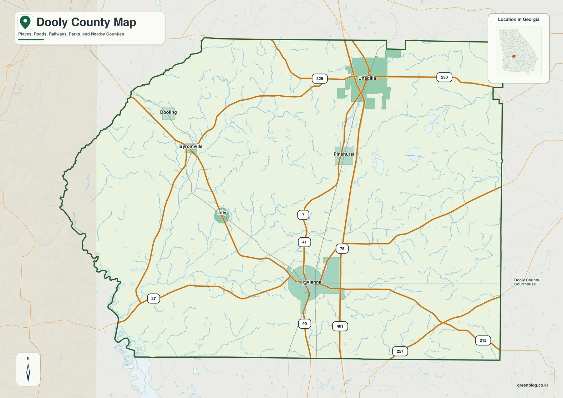
The boundary itself also changes character from one side of the county to another. The eastern and southern edges include long, relatively straight segments, while the western and southwestern side becomes more irregular where the county approaches the Flint River. On the general map, that shape can be compared directly with the road network and the blue stream lines. It is especially helpful for readers who need a county-level orientation image rather than a municipal boundary map or a parcel map.
The U.S. Census Bureau reports about 392.6 square miles of land area for Dooly County. That scale helps explain why the municipal labels appear widely separated. A county of this size can contain a county seat, interstate interchanges, small towns, agricultural land, river lowlands, and many miles of local streams without any one feature dominating the entire map.
Vienna, Unadilla, and the six incorporated municipalities
Georgia Department of Community Affairs records list six incorporated municipalities in Dooly County: the cities of Lilly, Pinehurst, Unadilla, and Vienna, plus the towns of Byromville and Dooling. Vienna is the county seat. The supplied city map places all six on the same county outline and adds an index, making it easier to compare where each community sits rather than treating the names as a simple alphabetical list.
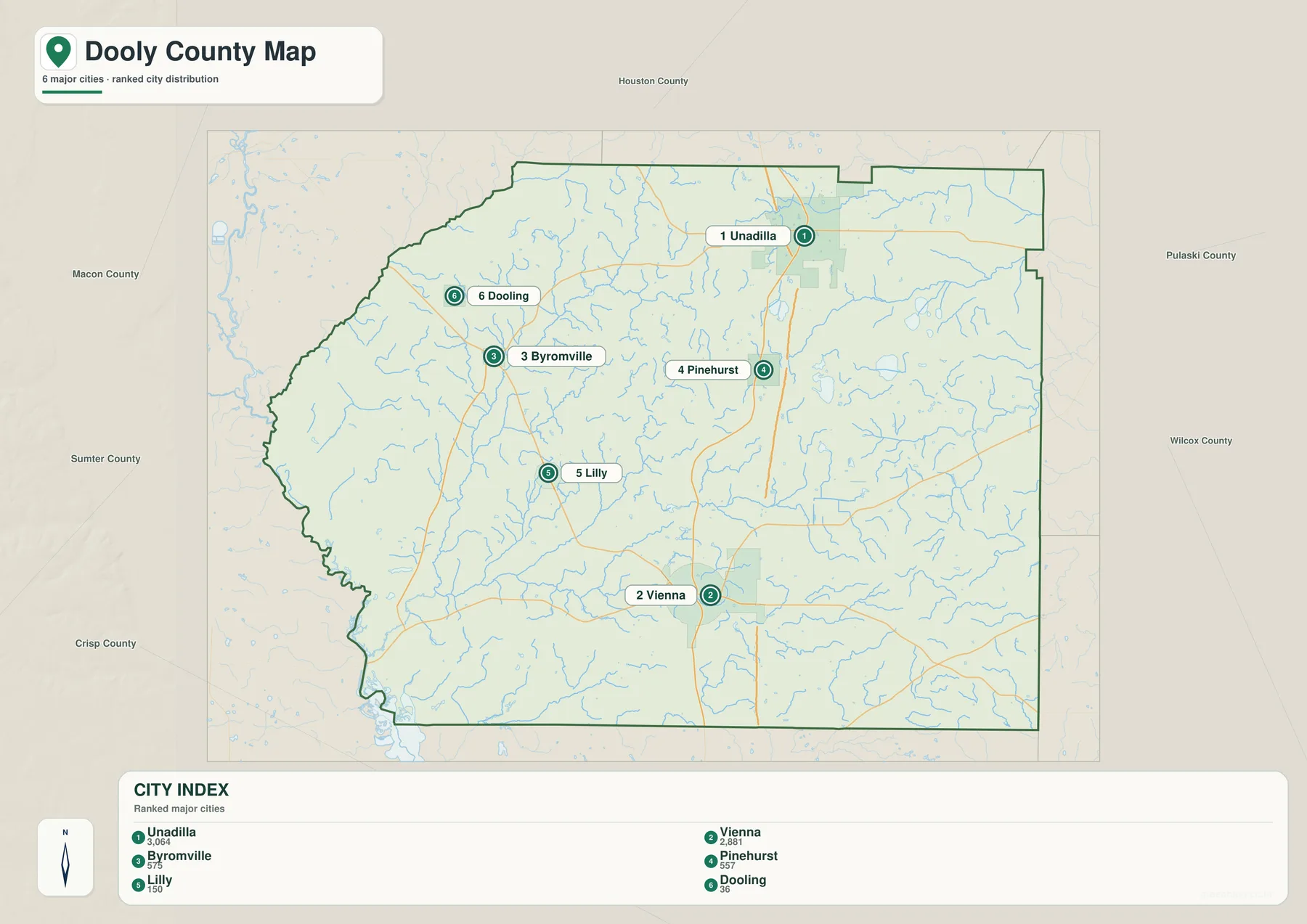
Unadilla is the northernmost of the larger labeled places and sits close to I-75 near the top of the county. Vienna lies in the south-central area, with Pinehurst between Vienna and Unadilla. That arrangement creates an obvious north-south line of communities on the eastern half of the county, although the map should not be read as a statement that all travel between them follows one road. US 41 and Georgia Route 7 provide a more central north-south reference, while I-75 runs just to the east of Vienna and continues north toward the Unadilla area.
The western half has a different pattern. Byromville lies in the northwest interior, Dooling is farther north and west, and Lilly sits below Byromville between the western communities and Vienna. Their spacing is useful for understanding why a single “main town” view can be misleading for Dooly County. The county seat is important administratively, but the incorporated places are distributed across a much wider rural area.
The index printed on the supplied city map ranks Unadilla first and Vienna second among the six labeled municipalities, followed by Byromville, Pinehurst, Lilly, and Dooling. Because the map itself does not state a data year beside those values, the safest use of the index is as a relative size cue within this specific map rather than as a substitute for a current population table. For current demographic figures, the Census Bureau source linked at the end of the page is the better reference.
I-75, US 41, and the county’s transportation pattern
I-75 is the most visually prominent through route on the county reference map. It runs north-south through the eastern half of Dooly County, passing east of Vienna and continuing toward Pinehurst and Unadilla. US 41 and Georgia Route 7 follow a more central path through Vienna toward Pinehurst, so the two north-south routes provide different ways to understand the relationship between the county seat and the northern municipalities.
Several state routes add east-west and diagonal connections. Georgia Route 90 crosses Vienna, Route 27 is labeled across the southwest, Route 329 crosses the northern part of the county, Route 230 extends east from the Unadilla area, and Routes 257 and 215 appear toward the southeast. The reference map is not detailed enough to replace a turn-by-turn road map, but it gives enough structure to see which communities are close to major corridors and which sit farther away from the interstate.
The 2022 Greater Dooly comprehensive plan adds useful context to what is visible on the map. It describes roughly 19 miles of I-75 exposure with five interchanges and notes that the county is crossed by two mainline railroads. Those transportation links help explain why the interstate and rail lines remain important reference features even in a county whose municipal centers are relatively small. For a local-history, economic-development, or travel-orientation graphic, showing the towns without the transportation network would leave out a major part of the county’s geography.
Creeks, ponds, and the Flint River side of the county
The water map shifts attention away from highways and municipality labels and toward the drainage network. The Flint River is labeled along the southwestern edge, where the county boundary bends around the river corridor. Numerous smaller streams spread through the interior, and several have names large enough to follow across the map. This makes the water view useful when the main question is not “Where is Vienna?” but “How do the local creeks relate to the lower western side of the county?”
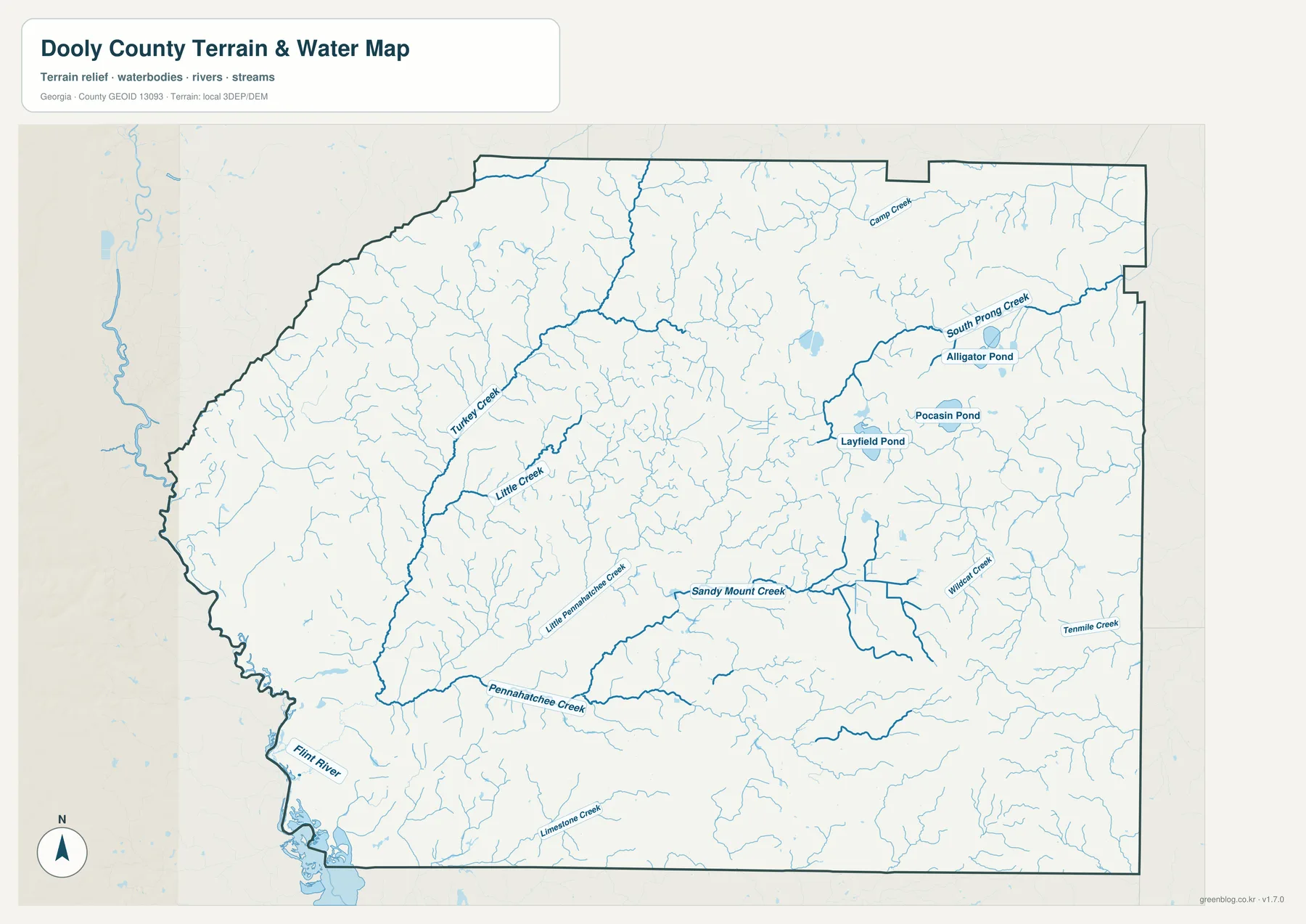
Turkey Creek is one of the clearest named streams in the western half, running from the north-central area toward the southwest. Little Creek appears nearby, while Pennahatchee Creek and Little Pennahatchee Creek are labeled farther south. Sandy Mount Creek crosses the central part of the county, and the eastern side includes Wilcat Creek and Tenmile Creek. Camp Creek and South Prong Creek are visible in the northeast, along with named water bodies such as Alligator Pond, Pocasin Pond, and Layfield Pond.
The value of this map is the way it reveals a dense web of small waterways that is easy to overlook on a road-focused map. It also provides a useful bridge to the elevation view, because many of the stream corridors correspond with lower strips of terrain. The map should not, however, be used as a flood-hazard product, a legal stream-boundary document, or a navigation chart. Anyone making a property, engineering, or flood-risk decision should consult the appropriate official source for that specific purpose.
Lower land near the Flint River and higher ground to the north and southeast
The locally scaled elevation map gives Dooly County more relief than a plain boundary map can show. Its legend lists an actual elevation range of about 72 to 148 meters and a mean of about 107 meters. Darker greens mark lower ground, while tan and brown tones mark higher areas. The result is not a picture of steep mountains; it is a county-scale view of gentle but meaningful elevation differences across the Coastal Plain landscape.
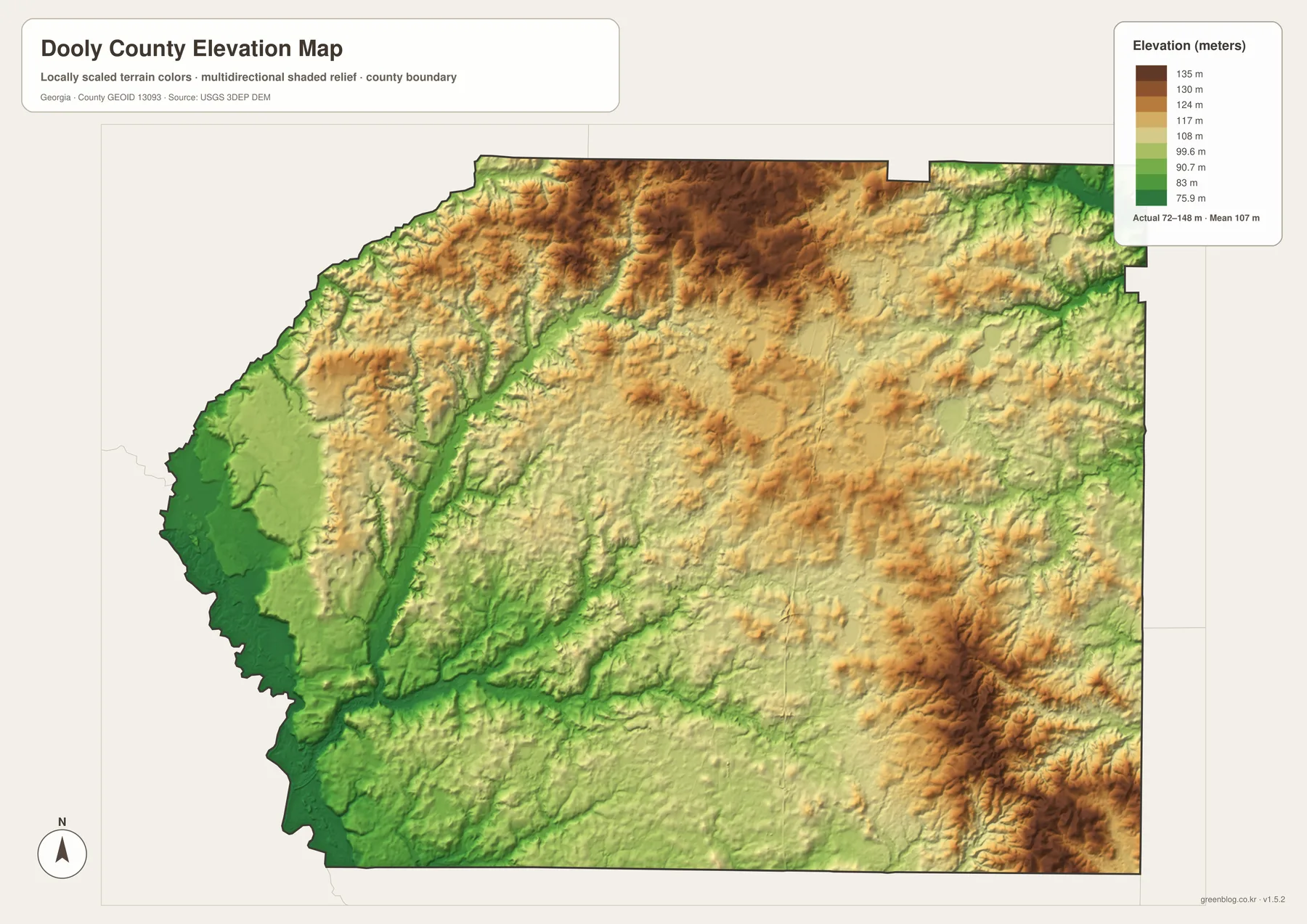
The lowest broad area appears along the west and southwest, matching the Flint River side of the county. Narrow green corridors also trace several creek valleys into the interior. The north-central part of the county rises into more extensive brown terrain, and a distinct higher area is visible toward the southeast. These contrasts help explain why the water network has a stronger visual connection to some low valleys even though the county as a whole does not have dramatic topographic relief.
This elevation surface is best used for regional orientation. It can help a student explain why the Flint River corridor is lower than much of the interior, help a writer describe the county’s terrain without relying on vague terms, or help a traveler understand that Dooly County contains rolling variation rather than a perfectly flat surface. It is not survey-grade elevation and should not be used to calculate building heights, drainage design, road grades, or construction quantities.
How to use the four maps together
For a first look at the county, start with the reference map because it combines the boundary, municipal labels, major roads, rail lines, and many stream lines in one view. If the task is specifically about where people live or how the six incorporated places are distributed, move to the city map. It removes some of the visual competition from the road network and makes the relative positions of Unadilla, Vienna, Pinehurst, Byromville, Lilly, and Dooling easier to compare.
The water and elevation maps work especially well as a pair. The water map names the Flint River and major creeks, while the elevation map shows the lower western river side and the higher ground elsewhere. A classroom presentation could use those two images to explain the relationship between streams and low terrain, while a local-history article might pair the city map with the county map to show how settlement locations relate to transportation routes.
None of the four should be stretched beyond its intended scale. The county map does not show every local road or unincorporated community; the city view does not define each municipal limit; the water view is not a flood map; and the elevation surface is not an engineering survey. Used within those limits, the set provides a clear and reusable overview for research notes, presentations, school work, travel orientation, county profiles, and other general reference needs.
The page previews are WebP images so the maps can load efficiently in a browser. The downloadable archive keeps the four original JPG versions together at higher resolution, which is more convenient when the maps need to be printed, placed in a document, or stored for repeated use.
Frequently Asked Questions
Where are Vienna and Unadilla within Dooly County?
Vienna is the county seat and sits in the south-central part of Dooly County. Unadilla is farther north near the I-75 corridor, while Pinehurst lies between the two. The city map is the clearest view for comparing those three locations with the western municipalities.
Does the Flint River form the entire western boundary?
No. The Flint River is most prominent along the southwestern side, where it runs close to and along part of the county edge, but the full western boundary is not simply one continuous river line. The water map makes the river-boundary relationship easier to see than the city map does.
Can the 72–148 meter elevation range be used for surveying or construction?
No. The elevation map is a county-scale reference surface designed to show relative terrain differences. Surveying, engineering design, drainage calculations, and construction work require current professional measurements and the appropriate detailed elevation data.
Map File Information
Dooly County A3 map files
- Printable Size: 3638 × 2572 pixels for each A3 map
Related Maps
Sources and References
These official resources are useful for checking county statistics, municipal planning information, boundaries, waterways, and elevation data used for county-scale reference mapping.
- U.S. Census Bureau QuickFacts for Dooly County
- Georgia Department of Community Affairs — Dooly County and Cities Comprehensive Plan
- U.S. Census Bureau TIGER/Line Shapefiles
- USGS National Hydrography
- USGS 3D Elevation Program
Green Map creates custom-edited map images using open geographic data sources such as geoBoundaries, Natural Earth, OpenStreetMap, and government open data. These maps are edited visual materials, not raw data files, and are provided for education, documents, presentations, and graphic reference.