High-resolution Dougherty County map files can be downloaded from this page as one ZIP containing four A3 JPGs. The article uses Albany as the main reference point, then follows the county boundary and road network toward the Flint River and the lower ground beside it. The supplied views also make it easier to compare named creeks, ponds, and the modest elevation changes across the county without turning the introduction into a list of map types. The downloadable originals are suited to printing, classroom work, presentations, and offline reference.
Albany is the strongest visual anchor across the set. On the general map it appears in the northern half of the county near several numbered routes, while the Flint River runs just to the east and then continues south. The broader city view also labels Lee, Terrell, Worth, Baker, Mitchell, and Calhoun counties around the outside of the frame. Those surrounding names are useful because they place Dougherty County within southwest Georgia without requiring a separate statewide map. Reading the maps together therefore gives a clearer picture than treating the county outline as an isolated shape.
Table of Contents
Start with Albany and the Dougherty County outline
The county reference map uses a dark boundary line to make Dougherty County stand out from the surrounding background. The western side forms a long outer edge, while the eastern boundary includes several steps and projections. Albany sits well east of the county’s geometric center, so the map immediately shows that the principal city and the midpoint of the county are not the same place. A small locator inset in the upper-right corner marks the county in southwestern Georgia, which is helpful when the main map is being used by someone who is not already familiar with the state.
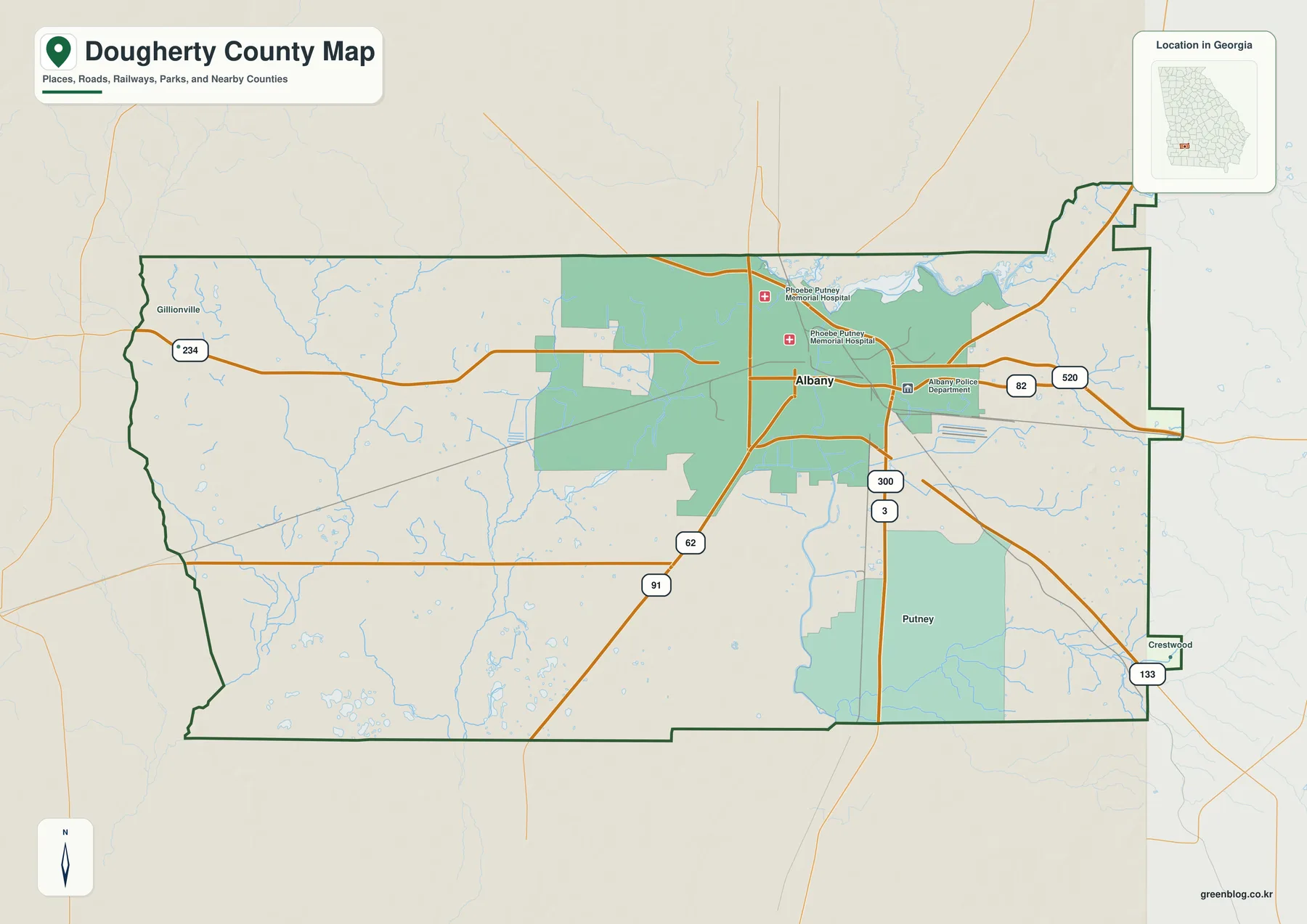
Road shields around Albany are especially useful for orientation. Routes 82 and 520 cross the Albany area from west to east, while 3 and 300 extend south from the city area. Other labels include 133 toward the southeast, 62 and 91 to the southwest, and 234 across the western part of the county. The map is not intended to replace a current navigation product, but it clearly shows the direction in which the larger routes leave Albany and how quickly the road network becomes less dense away from the urban center.
A few named facilities also help identify the built-up Albany area. Phoebe Putney Memorial Hospital and the Albany Police Department are labeled near the city, adding recognizable reference points without turning the page into a street map. Much of the western and southwestern portion of the county has no major city label on this map, so the contrast between the Albany area and the broader county is easy to see. That makes this version useful for a report introduction, a classroom handout, or any project that needs a readable boundary-and-location image rather than a dense road atlas.
Road directions and the surrounding county context
The city map adds another layer of orientation by printing nearby county names outside the Dougherty boundary. Lee County and Terrell County appear to the north, Worth County to the east, Baker County to the west, and Mitchell and Calhoun counties toward the southwest side of the frame. These labels are not a substitute for a detailed inter-county boundary map, but they make it much easier to explain where Dougherty County lies in relation to its neighbors. When Albany is used as the starting point, the directional relationship among the surrounding counties becomes intuitive.
The road pattern also explains why Albany dominates the general map. Several numbered routes come together in or near the city before spreading toward different sides of the county. The western half still contains roads and many small drainage lines, but the major route symbols are less concentrated there. For a reader trying to understand the county at a glance, this is more useful than a long list of highway names: Albany is the place where the strongest road signals, major facility labels, and the nearby Flint River appear close together.
Why the city map emphasizes Albany
The city map deliberately simplifies the settlement picture. Its City Index lists Albany as the single ranked major city, and a numbered marker identifies the city on the county map. This does not mean that Dougherty County contains no smaller communities or unincorporated places. It means that, under the ranking used for this map, Albany is the only major city selected for prominent display. That choice keeps the page legible and makes the relationship between the city, the county boundary, roads, and surrounding county names easier to follow.
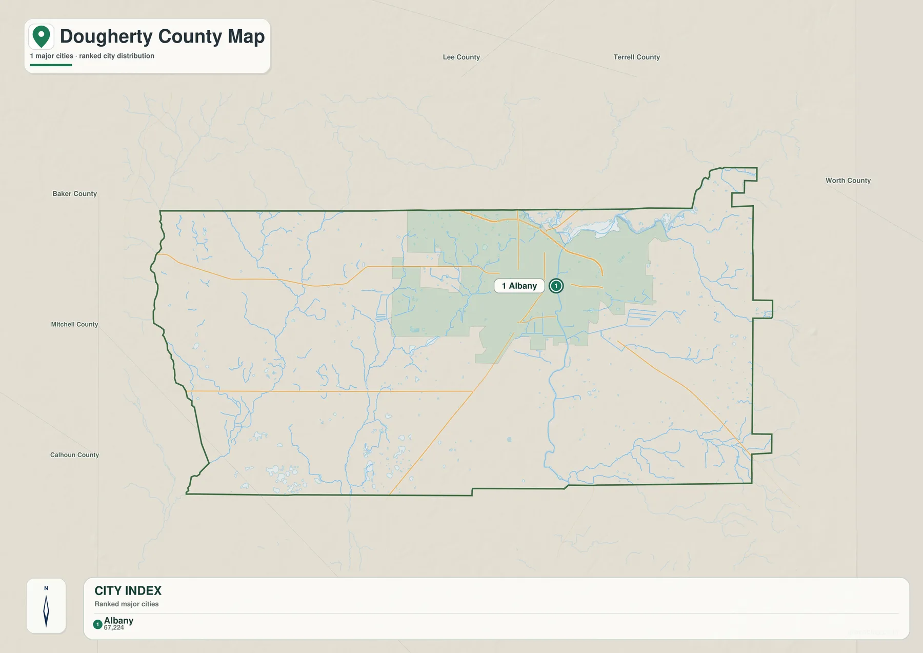
The Albany marker lies in the northern half of Dougherty County and east of the broad western portion of the county. Looking at this map beside the reference map separates two ideas that are easy to confuse: the administrative shape of the county and the location of its dominant city. The boundary extends far beyond Albany, especially to the west and southwest, even though the largest concentration of labels occurs around the city. This distinction is useful for geography lessons and for local-history projects that need a simple visual explanation of why a county can have one clear urban center inside a much larger administrative area.
Some county city maps include multiple ranked cities and connector lines. This particular Dougherty County map has only one ranked major city, so there are no city-to-city connector distances to interpret. Readers should focus instead on Albany’s relative position and on the directions of the larger roads. If the goal is to locate a small community, neighborhood, school, business, or individual address, a more detailed local map should be used alongside this county-level view.
The Flint River is the main feature on the water map
The water map shifts attention away from roads and makes the Flint River the strongest line in the county. The river enters near Lake Chehaw along the northern side of the mapped area, passes east of central Albany, and then runs south through the county before leaving the boundary. Because the river is drawn in a darker blue than the small drainage lines, its route is much easier to follow here than on the general reference map. This is the best version for a reader whose main question is how Albany and the rest of Dougherty County sit in relation to the Flint River.
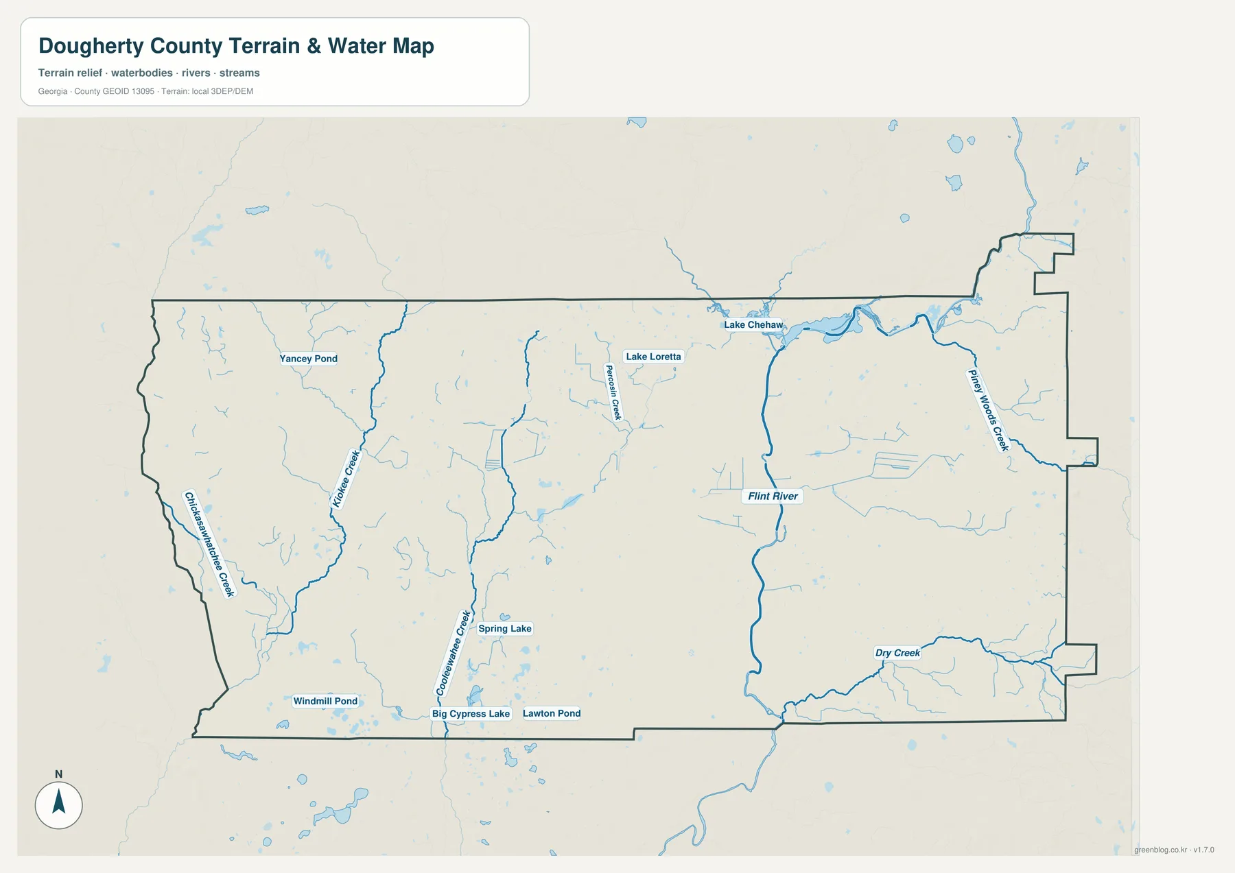
Several named creeks show that the county’s drainage is not limited to the Flint River corridor. Chickasawhatchee Creek and Kiokee Creek are labeled on the western side, Coolawahee Creek runs through the southwest, and Proctor Creek appears north of the central area. On the eastern side the map names Piney Woods Creek, while Dry Creek is labeled in the southeast. These streams give the western and eastern parts of the county their own visible water networks even though the Flint River remains the most prominent feature.
The map also labels a useful group of lakes and ponds. Lake Chehaw is the most conspicuous water body near the north side of the Flint River. Lake Loretta lies farther west, and the map marks Yancey Pond, Spring Lake, Windmill Pond, Big Cypress Lake, and Lawton Pond in other parts of the county. The purpose is location reference rather than recreation guidance. The map does not state water depth, boat access, fishing rules, water quality, or flood probability, so those topics require current specialized sources.
Small pale-blue drainage lines appear throughout the background, while the selected major creeks use darker strokes and labels. That hierarchy is useful when a reader wants to understand how a named creek fits into a larger network of smaller channels. It also shows why a water map should not be treated as a legal boundary product: streams may run close to a county edge in places, but the county boundary and the water network are different layers. For a formal boundary question, the Census Bureau TIGER/Line files are the better reference; for hydrography, the USGS National Hydrography resources provide the underlying kind of data suited to that task.
Elevation is lowest along the river corridor and rises near parts of the edge
The elevation map uses a locally scaled color range and shaded relief to show relatively small changes in height across Dougherty County. Across the mapped surface, the scale runs from roughly 44 to 118 meters, and the legend places the mean around 62 meters. Darker green represents the lower portions of the terrain, while yellow, tan, and brown mark progressively higher ground. The range is modest overall, yet the shaded surface makes clear that the county is not perfectly flat.
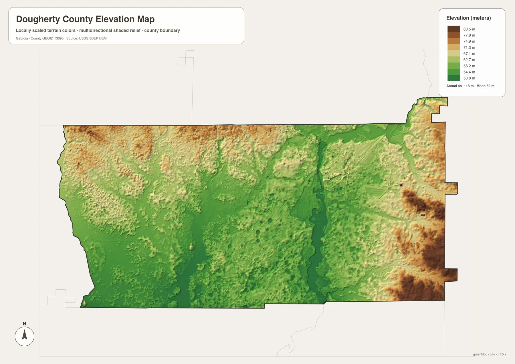
The easiest feature to match with the water map is the narrow low corridor following the Flint River. On the elevation map it appears as a darker green north-south strip through the eastern-central part of the county. Higher colors become more noticeable near the eastern edge, especially in the southeastern projections, and there are also textured higher areas across parts of the north and northwest. Much of the west and southwest remains green, but the relief shading reveals smaller ridges and depressions rather than one uniform plain.
Comparing the water and elevation maps is more informative than looking at the color legend alone. First locate the Flint River and Dry Creek on the water map, then return to the elevation map and find the corresponding lower corridors. The relationship between water and terrain becomes visible without requiring a technical GIS workflow. At the same time, the elevation surface is generalized for county-scale viewing. It should not be used to determine a construction grade, parcel elevation, drainage design, or any engineering measurement. Those tasks need the original elevation data or professional survey information.
Choose the map that matches the question
For a general county introduction, the reference map is the most efficient because it combines the county outline, Albany, selected roads, waterways, and a state locator. When the focus is settlement, the city map removes much of the competing detail and makes Albany the single ranked city marker. The water map is better for the Flint River and named creeks, while the elevation map is the clearest choice for explaining why the river corridor appears lower than parts of the eastern edge. Switching maps by topic keeps the page readable and prevents one image from becoming overloaded with labels.
A practical research sequence is to begin with the county map, note Albany and the numbered routes, and then move to the water map to identify the Flint River and nearby named streams. The elevation map can then be used to compare the river corridor with surrounding higher ground. For a school presentation, this sequence creates a clear story: administrative location first, water second, terrain third. For a printed handout, using only the one or two maps needed for the assignment usually works better than shrinking all four onto a single page.
The browser previews are WebP images sized for a webpage, but the downloadable archive is intended for higher-quality use. Each original JPG is 3638 by 2572 pixels, which preserves more detail when the map is enlarged or printed at an A3-like aspect ratio. The same four subject areas are included in the ZIP, so a reader can save the full set and decide later which map is most useful for a lesson, local-history note, research document, or presentation graphic.
Important limits before using the maps
These are county-scale reference maps, not parcel, survey, legal-boundary, navigation, or emergency-management products. The county outline is appropriate for general location work, but it does not display property ownership or individual parcel lines. The road layer is selective and does not show every local street, temporary closure, speed limit, or turn restriction. The city map is intentionally simplified, so the absence of a community name should never be interpreted as proof that the community does not exist.
The water map is likewise a location reference rather than a flood-risk map. It shows the Flint River, several named creeks, lakes, ponds, and many smaller drainage features, but it does not provide flood-zone boundaries, current river stage, navigability, public access, or water-quality conditions. The elevation map is useful for broad terrain comparison but is not survey-grade. If a project depends on an exact county line, hydrographic feature, or elevation measurement, consult the corresponding authoritative source rather than measuring from the illustration.
The earlier Dougherty County page also notes that the county was established in 1853 and describes Albany, the Flint River, healthcare, education, logistics, agriculture, and flood history as part of the local context. This rewrite keeps the map page focused on what the supplied graphics actually show. Time-sensitive population and planning information is better checked directly through U.S. Census Bureau QuickFacts and the Georgia Department of Community Affairs, while boundary, water, and elevation questions can be followed through the official data sources listed at the end of the page.
Frequently Asked Questions
Where is Albany on the Dougherty County maps?
Albany is shown in the northern half of Dougherty County, east of the broad western portion of the county. It is the county seat and the only ranked major city on the supplied city map. Routes 82 and 520 cross the Albany area, and several other numbered routes extend away from the city. The Flint River runs immediately to the east, making Albany easy to match between the road, city, water, and elevation views.
Which named water features appear on the water map?
The map labels the Flint River together with Chickasawhatchee Creek, Kiokee Creek, Coolawahee Creek, Proctor Creek, Piney Woods Creek, and Dry Creek. It also identifies Lake Chehaw, Lake Loretta, Yancey Pond, Spring Lake, Windmill Pond, Big Cypress Lake, and Lawton Pond. These labels are for geographic reference; the map does not provide flood risk, depth, access, fishing, or navigation information.
What does the 44–118 meter elevation range mean?
The elevation legend reports the actual range represented across the county as roughly 44 to 118 meters, with a mean around 62 meters. Dark green shows relatively lower ground and brown shows higher ground. The low strip along the Flint River is especially visible. The map is suitable for county-scale comparison, but a precise point elevation should be taken from the underlying elevation data or a survey rather than estimated from the colors.
What is included in the downloadable ZIP?
The download contains four original high-resolution JPG files: a county reference map, a city map, a water map, and an elevation map. Each image is 3638 × 2572 pixels. The WebP images in the article are lighter previews for online viewing, while the JPG versions are better suited to printing, enlargement, and offline use.
Map File Information
Dougherty County A3 map files
- Included Files: Four JPG map files provided with this article
- File Type: ZIP archive of JPG files
- Intended Use: Printing, education, presentations, and map-based projects
Related Maps
Sources and references
- U.S. Census Bureau QuickFacts for Dougherty County
- Georgia Department of Community Affairs – Dougherty County/Albany comprehensive plan
- U.S. Census Bureau TIGER/Line Shapefiles
- USGS National Hydrography
- USGS 3D Elevation Program
These official pages provide follow-up sources for county statistics and planning, administrative boundaries, hydrography, and elevation data. The descriptions above stay centered on the labels, roads, water features, boundary shape, and elevation range that are visible in the supplied Dougherty County map set.
Green Map creates custom-edited map images using open geographic data sources such as geoBoundaries, Natural Earth, OpenStreetMap, and government open data. These maps are edited visual materials, not raw data files, and are provided for education, documents, presentations, and graphic reference.