Okaloosa County Map pages make the most sense when the long north-to-south shape of the county is considered together with the roads and water. Laurel Hill and Crestview sit in the northern interior, while Niceville, Valparaiso, Fort Walton Beach, Mary Esther, and Destin are concentrated around Choctawhatchee Bay and the Gulf coast. A broad central area associated with Eglin Air Force Base separates much of the northern settlement from the southern municipalities. This page uses the supplied county, city, and water maps to explain those relationships, and the download box below provides a ZIP with three high-resolution A3 JPG map files.
The maps also explain why a short straight-line distance does not always mean a simple drive. I-10 and US 90 form the main east-west corridor around Crestview, SR 85 runs north and south through the county, and US 98 serves the coastal side. Around Choctawhatchee Bay, bridges and bay crossings become just as important as mileage. SR 293, for example, crosses the bay between the Niceville side and the Destin side, while US 98 follows a different coastal route through Fort Walton Beach and Okaloosa Island before reaching Destin.
Table of Contents
A long Panhandle county from the Alabama line to the coast
Okaloosa County stretches from the Alabama border in the north to Choctawhatchee Bay, Santa Rosa Sound, and the Gulf shoreline in the south. Santa Rosa County lies to the west and Walton County to the east. On the general county map, Laurel Hill appears near the northern edge, Crestview occupies the north-central part of the county, and the main coastal communities sit much farther south. The elongated outline is one of the first things to notice because it separates two very different parts of the county: an inland river country and a bay-centered coastal area.
Crestview is the county seat and a useful reference point for reading the northern road network. I-10 passes just south of the city, US 90 crosses the urban area from east to west, and SR 85 runs through the county in a north-south direction. Laurel Hill lies farther north along SR 85. West and south of Crestview, the map shows a more rural pattern of roads and waterways rather than the closely spaced coastal municipalities found near the bay.
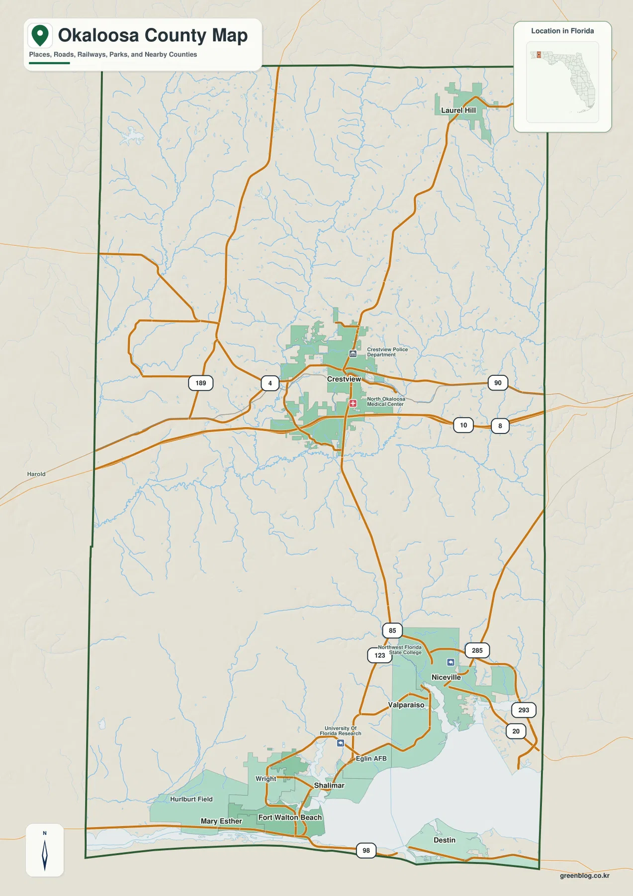
The southern part of the county has a very different arrangement. Niceville and Valparaiso are on the north side of Choctawhatchee Bay, while Fort Walton Beach and Mary Esther are near the western approaches to the bay and Santa Rosa Sound. Destin occupies the narrow coastal area south of the bay. These places can appear close when viewed across open water, but bridges, inlets, military land, and the bay itself determine the routes between them.
Crestview and the cities around Choctawhatchee Bay
The city map simplifies the county by highlighting the major municipalities and their relative positions. Crestview is separated from the southern group, while Fort Walton Beach, Niceville, Destin, Valparaiso, and Mary Esther are clustered closer to Choctawhatchee Bay and the coast. That grouping does not mean the southern cities form one continuous urban strip. Water, bayous, military property, and bridge crossings divide the area into distinct communities with different road approaches.
Niceville lies north of Choctawhatchee Bay with Valparaiso close by to the southwest. Fort Walton Beach is positioned toward the western end of the bay and near Santa Rosa Sound, and Mary Esther extends west of Fort Walton Beach. Destin is south of the bay on the coast. Because Niceville and Destin face each other across the bay, SR 293 and the Mid-Bay Bridge provide an important direct connection, while US 98 serves a different route around the western coastal side.
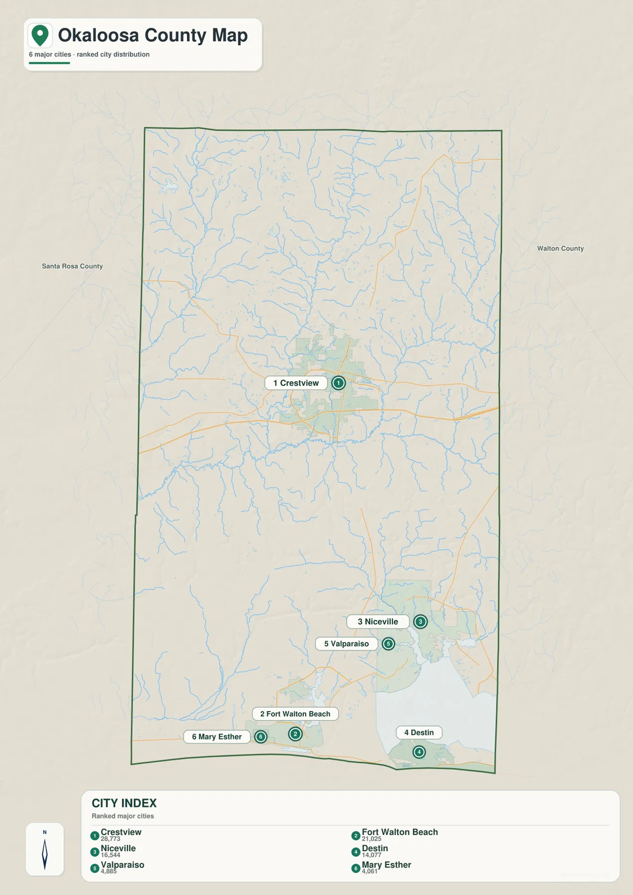
The broad gap between Crestview and the southern cities is also meaningful. Eglin Air Force Base occupies a large testing and training reservation across the middle and southern interior of the county. Existing county material describes the reservation as roughly 464,000 acres, which helps explain why urban streets do not form a continuous band between Crestview and the coast. Roads that cross or skirt this area follow designated corridors rather than the shortest possible straight line.
Roads change as the map moves from Crestview to the bay
I-10 and US 90 are the easiest roads to use when orienting the northern part of Okaloosa County. Both run east and west around Crestview and connect toward Santa Rosa County on one side and Walton County on the other. SR 85 provides the clearest north-south route, linking the Laurel Hill and Crestview area with the direction of Fort Walton Beach. Near the Eglin reservation, designated connections such as SR 123 matter because the central military land does not function like an ordinary street grid.
Along the coast, US 98 becomes the main reference road. It serves Mary Esther and Fort Walton Beach, continues across the Santa Rosa Island section commonly called Okaloosa Island, and then crosses East Pass toward Destin. Okaloosa Island and Destin are neighbors, but they are not the same city or the same continuous land area. East Pass and the bridge crossing between them are important orientation points on the coastal map.
SR 293 serves a different purpose. It crosses Choctawhatchee Bay on the Mid-Bay Bridge between the Niceville side and the Destin side, avoiding the longer route through Fort Walton Beach and Okaloosa Island. That difference is useful for understanding travel decisions inside the county: a route that makes sense from Niceville is not necessarily the route a driver would choose from Fort Walton Beach or Crestview. Reading the road numbers together with the bay makes those choices much easier to understand.
Rivers in the interior, Choctawhatchee Bay on the coast
The water map reveals a dense network of streams in the northern and central parts of the county. The Blackwater River appears near the northwestern side, while the Yellow River and its tributaries cross the interior. The Shoal River bends across the eastern and south-central area, and smaller named waterways such as Jumper Creek and Titi Creek add to the network. These features show that northern Okaloosa is not simply a flat block of inland land; rivers and tributaries divide it into many small drainage areas.
Farther south, the scale of the water changes. Choctawhatchee Bay dominates the lower county, with Santa Rosa Sound and The Narrows toward the west. Around Fort Walton Beach, Cinco Bayou is labeled, while Destin Harbor and Joe’s Bayou appear near Destin. The bay, sound, harbor, and smaller bayous explain why the coastal communities are arranged around narrow pieces of land and why bridge crossings are so important for local travel.
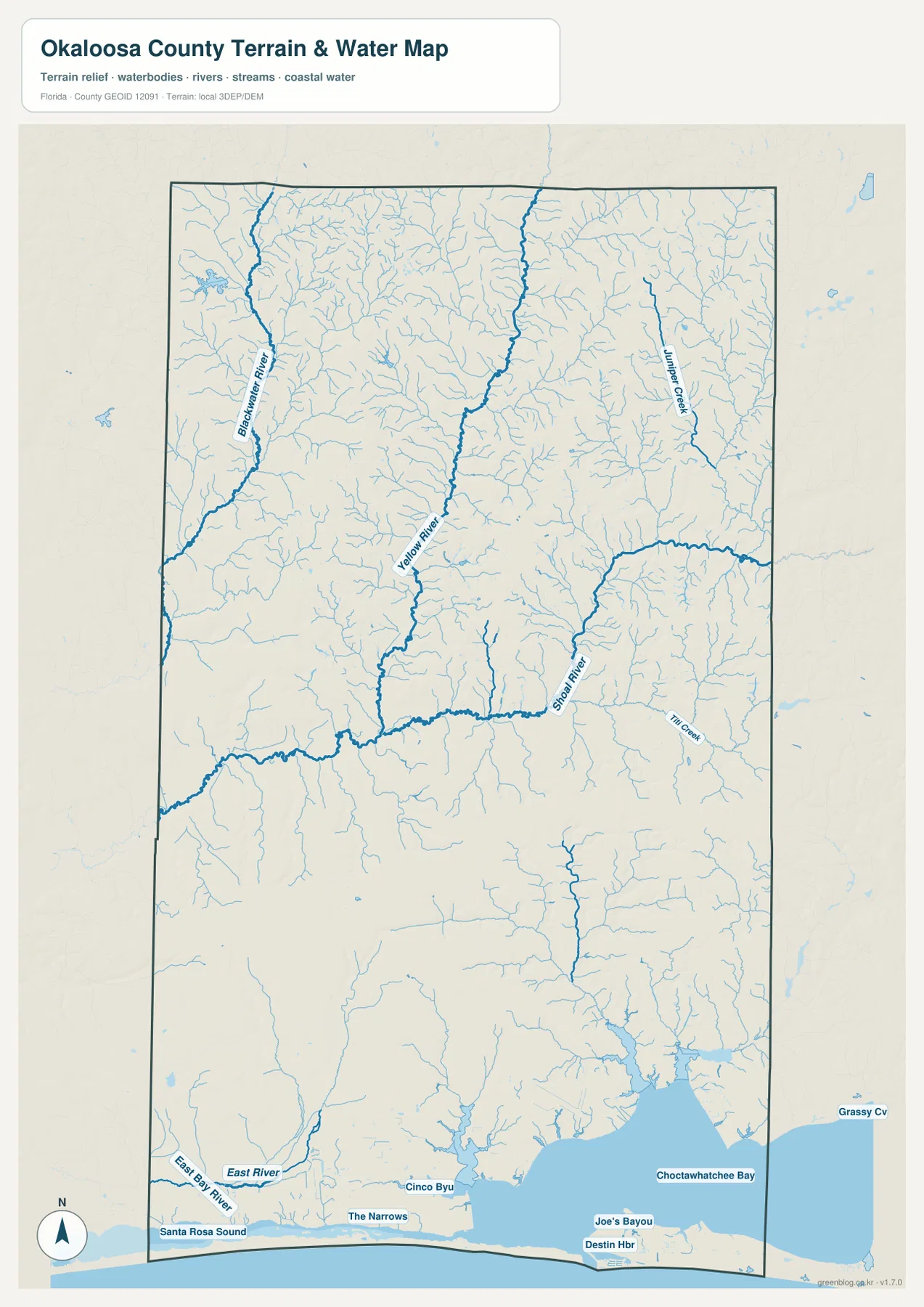
This water map is best used as a location reference, not as a flood-risk or navigation chart. It helps show which rivers cross the interior, where Choctawhatchee Bay sits relative to Niceville and Destin, and why Fort Walton Beach and Destin are separated by water features and bridge approaches. When paired with the county map, the water layer provides a simple explanation for several road curves and crossings that otherwise look indirect.
Choosing the right view for a specific question
The general county map is the best starting point for the full north-south layout. It shows Laurel Hill, Crestview, Niceville, Fort Walton Beach, and Destin in one frame and makes the major road pattern easy to follow. The city map reduces the detail and is more useful when the goal is simply to compare where the main municipalities are located. The water map adds the Yellow and Shoal river systems, Choctawhatchee Bay, Santa Rosa Sound, and coastal inlets that shape the lower county.
For travel planning, the road-and-water relationship is usually more useful than straight-line distance. For classroom or reference use, the maps illustrate how one county can include an inland county seat, a very large military reservation, river country, bay-side municipalities, a barrier-island corridor, and a Gulf-facing city. The three views are therefore most useful when they answer different questions rather than when every label is forced onto one crowded map.
Frequently Asked Questions
Are Okaloosa Island and Destin the same place?
No. Okaloosa Island is a coastal area on Santa Rosa Island, while Destin is an incorporated city east of East Pass. US 98 crosses the water between them, so they are close neighbors but should not be treated as one place.
Which road crosses Choctawhatchee Bay directly between the Niceville side and Destin?
SR 293 uses the Mid-Bay Bridge across Choctawhatchee Bay. It is a different route from US 98, which serves Fort Walton Beach and Okaloosa Island before reaching Destin.
Why does the area between Crestview and the coastal cities look sparsely developed?
A large part of central Okaloosa County is occupied by the Eglin Air Force Base testing and training reservation. It does not have the dense civilian street pattern of a normal urban corridor, so roads and built-up areas appear much less continuous between Crestview and the coast.
Map File Information
The ZIP below contains the Okaloosa County general map, city map, and water map as high-resolution A3 JPG files.
- Included Files: county map JPG, city map JPG, water map JPG
Related Maps
- Arcadia Roads and Peace River | DeSoto County Florida Map
- Baker County Florida Map
- Between the Aucilla and Withlacoochee: Madison County Florida Map
Sources and References
- U.S. Census Bureau QuickFacts for Okaloosa County – county statistics and general reference.
- Okaloosa County towns and municipalities – incorporated places in the county.
- Florida Department of Transportation I-10 exit information – northern highway reference.
- Florida Department of Environmental Protection Okaloosa County coast guide – coastal and water context.
- Eglin Air Force Base natural-resources information – central reservation context.
Green Map creates custom-edited map images using open geographic data sources such as geoBoundaries, Natural Earth, OpenStreetMap, and government open data.
These maps are edited visual materials, not raw data files, and are provided for education, documents, presentations, and graphic reference.