Sequatchie County is one of those places where the shape of the land explains the map almost immediately. Dunlap sits on the lower floor of Sequatchie Valley, while higher terrain rises sharply on both sides. The Sequatchie River follows that low corridor and receives numerous creeks descending from the surrounding slopes. This Sequatchie County Map set brings those relationships together with a county reference map, a city-focused map, a waterways map, and an elevation map. After comparing the layers below, you can download the original high-resolution A3 JPG files in one ZIP archive.
The contrast between the valley floor and the surrounding uplands is more useful here than a long list of place names. Dunlap provides the clearest urban and administrative reference, US 127 and SR 111 give the road network an easy frame, and the river system shows why much of the visible development and transportation is concentrated in the lower corridor. The 2020 Census counted 15,826 residents in the county, while the Census Bureau’s July 2025 estimate is 17,861, a 12.9 percent increase from the 2020 estimate base. Those figures describe the county as a whole; the maps help show why population and roads are not spread evenly across its terrain.
Table of Contents
Start with Dunlap, then follow the county’s long outline
The general county map places Dunlap near the middle of the populated valley and gives it a larger visual footprint than the smaller labels around it. Cagle appears to the north, while New Hope and Lone Oak provide useful references farther south. The boundary stretches well beyond those communities, especially toward the northwest and along the long angled eastern side, so the map does not read like a compact square county. Dunlap works as a practical starting point because both the road network and the lower valley are easy to recognize from there.
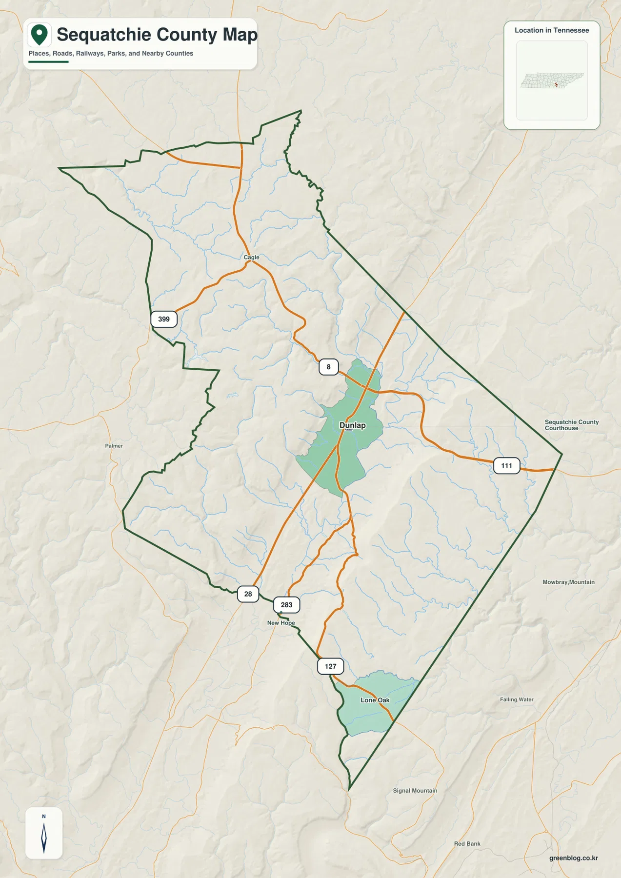
US 127 is one of the easiest routes to trace because it passes through Dunlap and follows the valley corridor. SR 111 approaches from the east and also meets the Dunlap area, while the map labels additional route numbers including 8, 28, 283, and 399. Together they show how travel is organized around a limited number of practical crossings and valley routes rather than a uniform street grid. The map is not intended to replace current navigation or construction information, but it clearly shows which roads matter at county scale.
The county boundary also deserves attention because several neighboring labels sit close to its edge. Census geography identifies Bledsoe, Hamilton, Marion, Grundy, Van Buren, and Warren counties as Sequatchie’s neighbors. On a shaded base map, a road or stream can continue beyond the dark county line without a dramatic visual break. Checking that boundary first prevents an outside community or road segment from being mistaken for a feature inside Sequatchie County.
| County fact | Value |
|---|---|
| County seat | Dunlap |
| FIPS code | 47153 |
| 2020 Census population | 15,826 |
| July 2025 population estimate | 17,861 |
| 2020 land area | 265.85 square miles |
| 2020 population density | 59.5 people per square mile |
| Key map references | Dunlap, US 127, SR 111, Sequatchie River |
Sequatchie County was created in 1857, and Dunlap developed at Coops Creek soon afterward as the county seat. That history is useful because Coops Creek is still visible on the waterways layer, connecting an early county reference with the modern map. The point is not to turn this page into a history lesson, but to show why Dunlap and the creek network are meaningful geographic anchors rather than arbitrary labels.
The city layer makes Dunlap the unmistakable center
The city map strips away some of the smaller settlement labels and emphasizes Dunlap as the ranked major city in this map set. That simpler treatment is useful when the question is not “Where is every named place?” but “Where is the county’s main urban center?” Dunlap stands out against a quieter background of streams, terrain shading, and neighboring county names, making the map easier to use in a presentation, worksheet, or regional comparison.
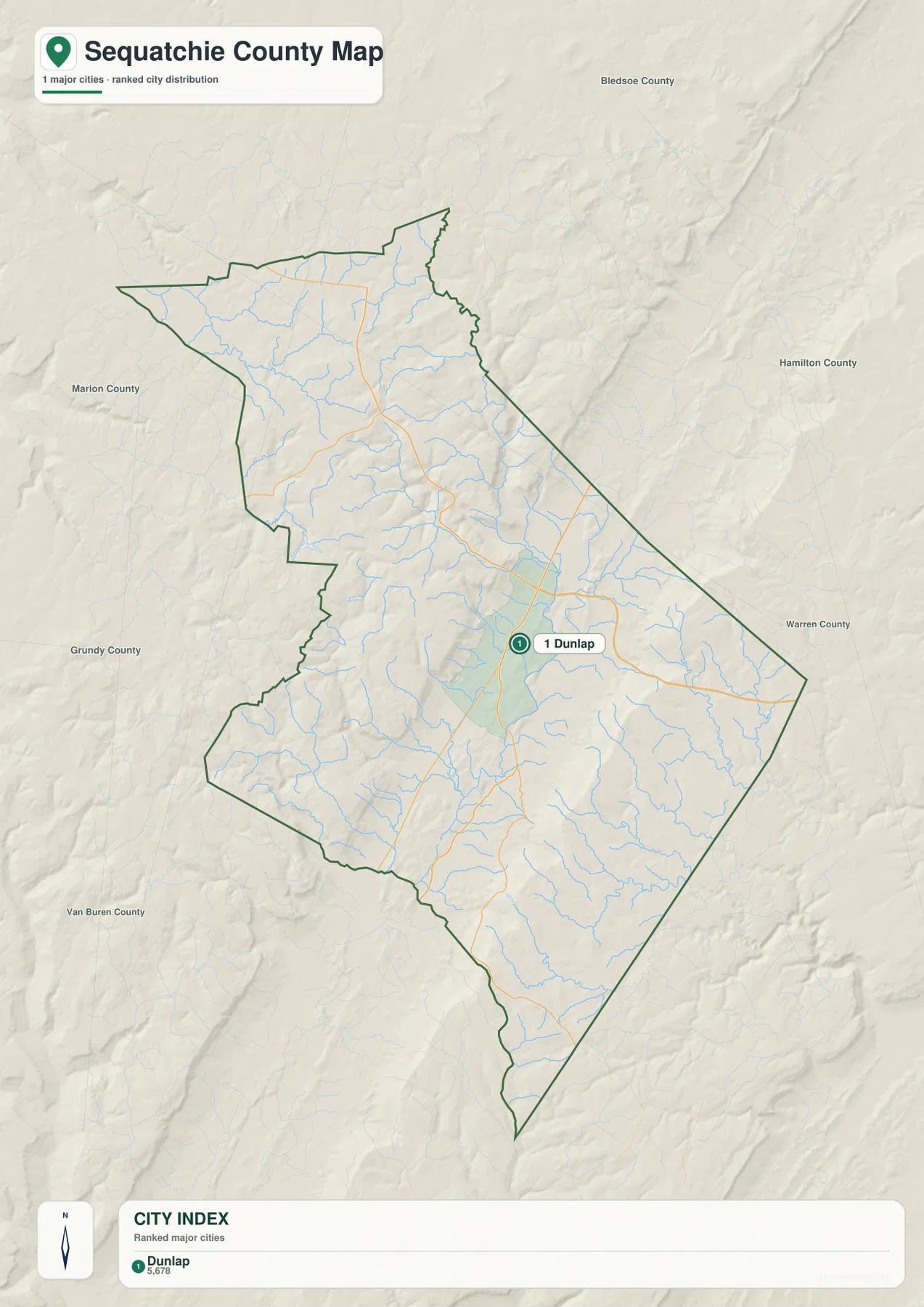
Dunlap lies on the lower valley floor rather than on one of the high outer ridges. The general map shows US 127 and SR 111 converging around the same area, while the city map makes the settlement concentration easier to see without competing labels. This is particularly useful when comparing urban location with elevation: the main city occupies the broad green lowland seen on the elevation map, not the steep brown terrain along the county’s outer sides.
The countywide density of 59.5 people per square mile should therefore be treated as an average, not as a description of every part of the map. A large share of the county is rugged upland or steep valley wall, while Dunlap occupies the more accessible valley corridor. The city and elevation maps make that contrast visible without requiring a detailed demographic layer.
Use the city layer when a clean location reference matters more than local detail. If the task requires Cagle, New Hope, Lone Oak, smaller route numbers, or the full stream network, switch back to the general county map or the water map. The four files are designed to separate those purposes rather than force every label into one crowded image.
The Sequatchie River gathers creeks from both sides of the valley
The waterways map gives Sequatchie County a very different appearance. Instead of roads and city blocks taking visual priority, the Sequatchie River becomes the main line through the lower valley. Tributaries descend from both sides and join it at different points. Named examples visible on the map include Dry Creek, Big Brush Creek, Little Brush Creek, Coops Creek, Cooper Creek, and Cain Creek, along with several smaller branches.
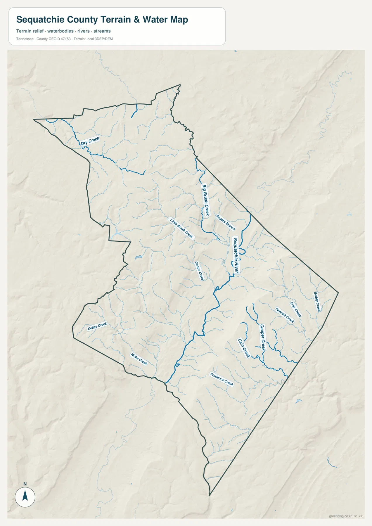
That branching pattern makes more sense when compared with the terrain. The outer parts of the county are higher, so many small channels run down toward the lower central corridor. The Sequatchie River then follows the valley rather than cutting randomly across the uplands. Coops Creek is especially useful as a local reference because Dunlap’s early development was tied to that creek, and the modern road and city maps still place Dunlap in the same low valley setting.
The water layer can also explain why short straight-line distances do not always translate into simple travel. A creek valley, steep slope, or limited crossing may shape where a road can go. The map does not show bridge conditions, flood stages, private access, or navigable water, so it should not be used as a boating or flood-hazard product. Its strength is county-scale orientation: it shows the named drainage network and how that network fits the valley.
For classroom work, the map is useful for tracing a tributary from a higher side of the county down to the Sequatchie River. For local orientation, it can be paired with the road map to see where a route follows a creek, crosses one, or stays on the broader valley floor. That comparison provides more geographic information than either layer can offer by itself.
Elevation reveals a narrow low corridor between much higher ground
The elevation map is the clearest visual summary of Sequatchie County’s physical setting. A long green lowland runs through the county, while yellow, tan, and brown terrain rises quickly on both sides. The map legend reports an actual elevation range of roughly 200 to 727 meters and a mean elevation of about 504 meters. That spread is large enough to make the valley floor and its surrounding rims look like different landscapes even within the same county.
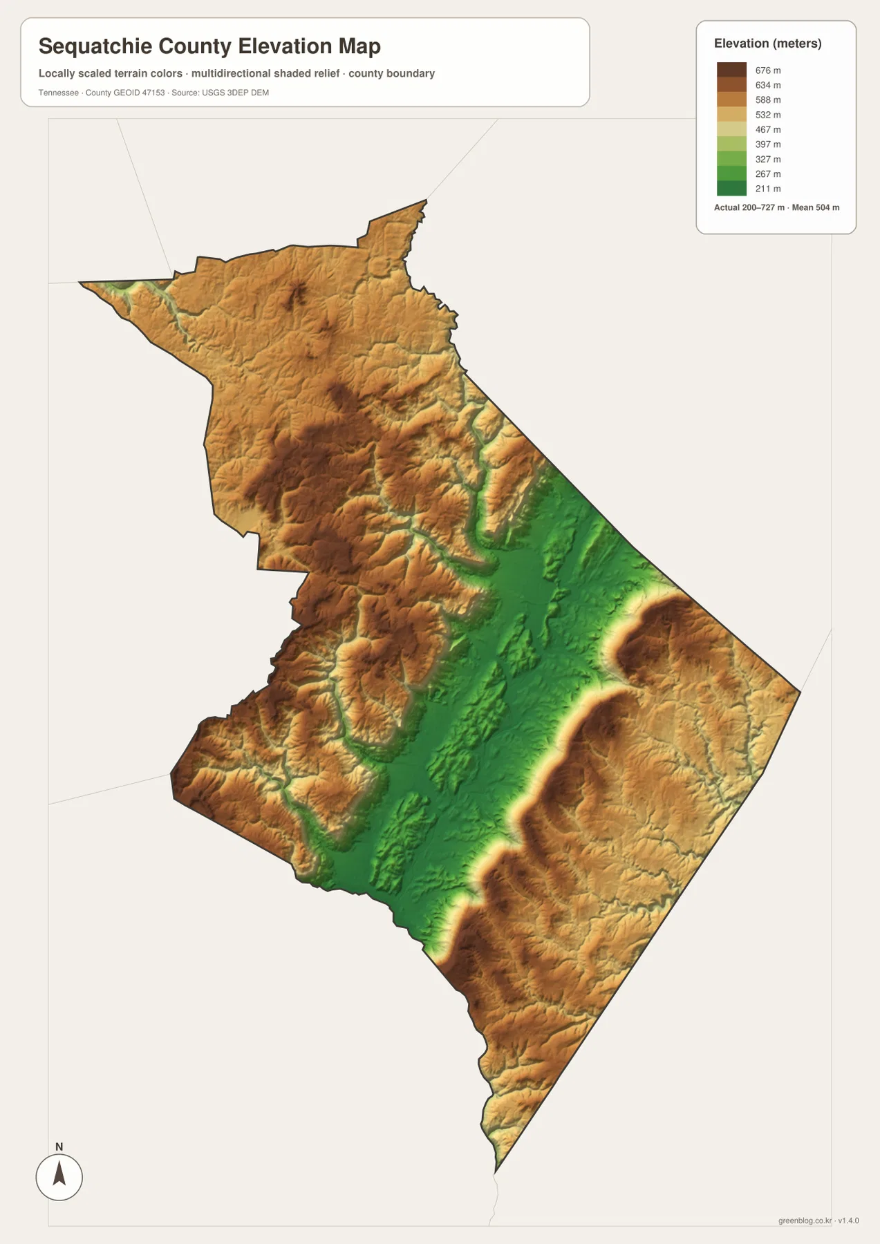
The low corridor aligns closely with the location of Dunlap and the Sequatchie River. That makes the elevation map a useful explanation for patterns seen elsewhere: US 127 follows the accessible valley, tributaries descend from the higher sides, and the central settlement area occupies flatter ground. On the outer slopes, the shaded relief becomes more broken and deeply cut, especially where small streams have carved narrow valleys into the uplands.
Sequatchie Valley is a long, deeply lowered feature within the broader Cumberland Plateau region, and the county map captures a striking section of it. The higher land on either side creates a strong visual frame around the valley rather than a gradual, almost flat transition. That is the geographic feature most worth noticing before trying to memorize smaller roads or creek names.
The colors are intended for relative comparison across the county. They should not be treated as survey-grade elevations for a building site, engineering design, or legal property work. For those tasks, use an appropriate current elevation or survey source. For a county-level overview, however, the map is very effective at separating the low valley floor from the high ridges and plateau surfaces around it.
Choose the layer by the question you need to answer
The maps work best when each one is given a clear job. Use the general county map for boundaries, named communities, and route numbers. Use the city map when Dunlap’s location is the main point and extra labels would only add clutter. The water map is better for the Sequatchie River and its tributaries, while the elevation map explains the low valley and the much higher terrain around it.
- County orientation: use the general map for Dunlap, Cagle, New Hope, Lone Oak, roads, and the full boundary.
- Urban reference: use the city map when you want Dunlap to be the immediate focal point.
- Drainage study: use the water map for the Sequatchie River, Coops Creek, Brush creeks, and other named tributaries.
- Terrain comparison: use the elevation map to distinguish the low valley from high outer slopes.
- Printing and annotation: use the A3 JPG files when you need room for labels, notes, routes, or classroom marking.
When combining maps in one project, avoid repeating the same explanation under every image. A useful sequence is to establish Dunlap and the county boundary first, then show the river network, and finally use elevation to explain why those roads and waterways occupy the corridor they do. This keeps the county-specific geography at the center of the page and makes the downloadable files easier to choose.
Frequently Asked Questions
Why is Dunlap the best first reference on a Sequatchie County map?
Dunlap is the county seat and the most prominent city on the supplied maps. It sits in the low Sequatchie Valley near the county’s principal road references, including US 127 and SR 111, and close to the river-and-creek network. Once Dunlap is located, Cagle to the north and New Hope and Lone Oak to the south help establish the county’s long shape and the direction of the valley.
What does the elevation map explain that the road map does not?
The road map shows where routes go, but the elevation map explains the terrain around them. The low green valley containing Dunlap and the Sequatchie River is bordered by much higher ground, with the supplied elevation layer ranging from about 200 to 727 meters. Seeing that contrast helps explain why major roads and settlements favor the valley corridor and why many creeks descend from the outer slopes toward the river.
What is included in the downloadable ZIP?
The archive contains four high-resolution JPG files: the general county map, the Dunlap-focused city map, the Sequatchie River and creek map, and the elevation map. They are prepared for A3 use and are better suited to printing or annotation than the smaller WebP previews shown in the article. For turn-by-turn navigation, flood decisions, surveying, or legal boundaries, use the relevant current agency source instead.
Map File Information
The ZIP contains the Sequatchie County reference map, city map, water map, and elevation map as high-resolution A3 JPG files. Use the WebP images above for quick viewing and the JPG originals when you need a larger printable or editable copy.
- Included Files: county map, city map, water map, and elevation map
- File Type: ZIP containing 4 JPG files
Related Maps
- Alamo to Gadsden: A Crockett County Tennessee Map
- Altamont, Monteagle, and Plateau Valleys — Grundy County Tennessee Map
- Around Chattanooga: Hamilton County Tennessee Map
Sources and References
- Sequatchie County Government history
- Tennessee Department of Transportation Sequatchie County map
- U.S. Census Bureau QuickFacts for Sequatchie County
- U.S. Census Bureau TIGER/Line boundary data
- USGS National Hydrography
- USGS 3D Elevation Program
Green Map creates custom-edited map images using open geographic data sources such as geoBoundaries, Natural Earth, OpenStreetMap, and government open data. These maps are edited visual materials, not raw data files, and are provided for education, documents, presentations, and graphic reference.