Nassau County Florida Map coverage has to explain more than a single coastal city. Nassau County sits at the northeastern corner of Florida, where Amelia Island and Fernandina Beach face the Atlantic while Yulee, Callahan, and Hilliard occupy very different mainland settings. The St. Marys River follows the Georgia boundary across the north, and the Nassau River, Amelia River, marshes, and tidal channels shape the southeastern side. This page compares the county map, city map, and water map so those relationships are easy to follow, and the download box below provides a ZIP with three high-resolution A3 JPG maps.
The county becomes much easier to understand when you read it from east to west. Amelia Island creates a narrow coastal edge, Yulee sits at the mainland gateway near I-95, Callahan connects the western road network, and Hilliard lies farther north toward Georgia. Water is just as important as roads: the St. Marys River defines the state line, the Nassau River crosses the southeastern interior, and the Amelia River separates much of the island from the mainland. Looking at these features together explains why short straight-line distances do not always match the way people actually travel through Nassau County.
Table of Contents
Amelia Island and the mainland are two very different parts of Nassau County
The eastern edge of the county map is dominated by Amelia Island. Fernandina Beach occupies the northern part of the island, with the Atlantic Ocean to the east and the Amelia River and tidal marshes on the mainland side. The St. Marys River reaches the coast just north of the city, while Nassau Sound lies beyond the southern end of the island. That geography gives Fernandina Beach a setting that is quite different from inland Nassau: beaches, inlets, marshes, and channels surround the city on several sides.
Fernandina Beach is the county seat, but it is not the only place that matters for understanding the eastern half of the county. Yulee lies on the mainland west of Amelia Island, close to I-95, US 17, and SR 200/A1A. Yulee is not an incorporated city; it is an unincorporated community and census-designated place. Even so, its position makes it one of the most useful reference points on the map because trips between the interstate corridor and Amelia Island pass through the Yulee area.
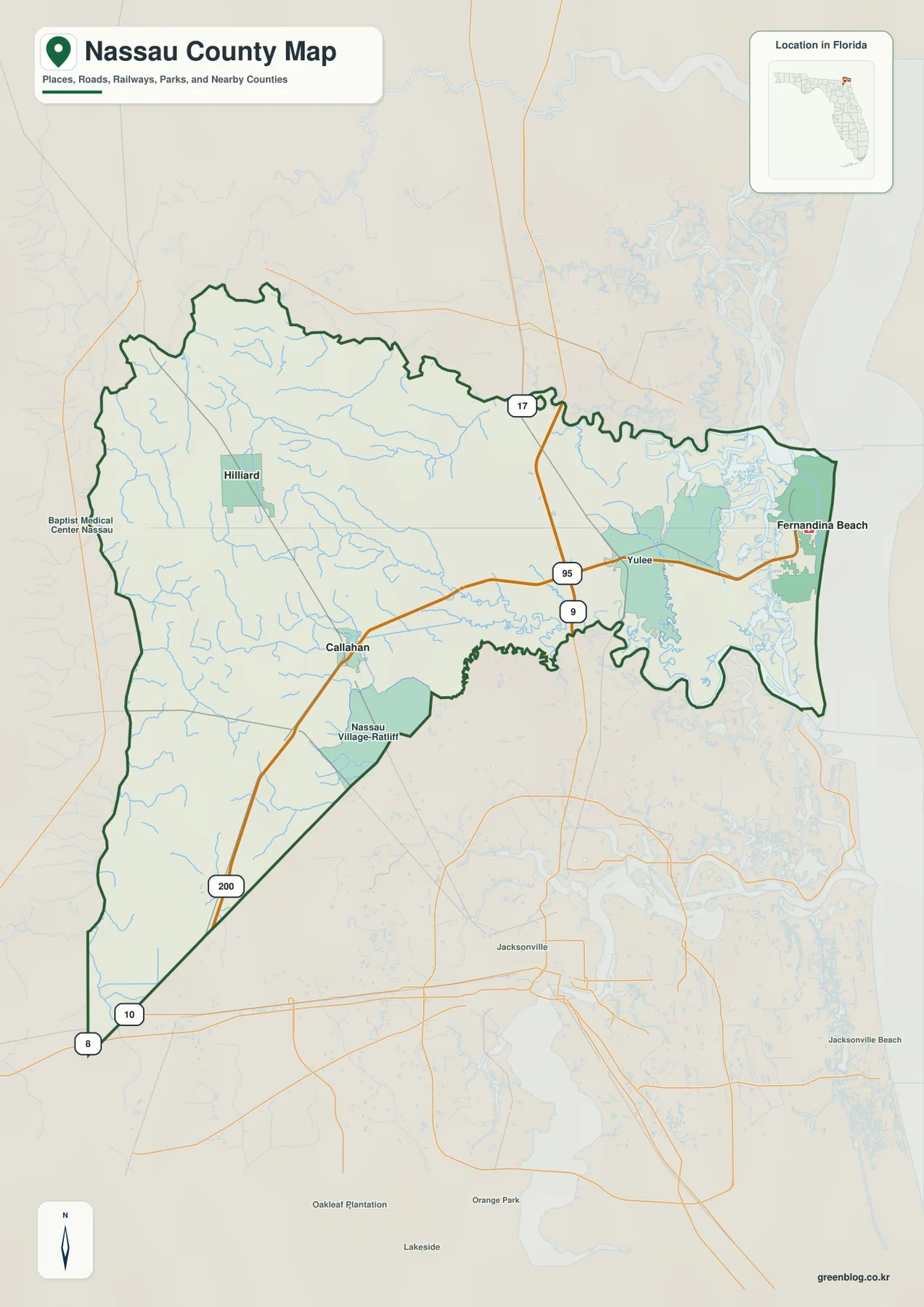
Moving west changes the pattern again. Callahan sits where US 1 and SR 200 help organize the interior road network, while Hilliard is farther north along US 1 and closer to the Georgia line. The southwestern side of the county shows fewer major place labels and a broader pattern of forests, wetlands, and small streams. This contrast between a highly visible coastal destination and a more rural western interior is one of the main reasons a countywide map is useful here.
The roads that organize Fernandina Beach, Yulee, Callahan, and Hilliard
I-95 is the main north-south reference line on the eastern mainland. SR 200/A1A crosses the interstate, continues through Yulee, and heads east toward Amelia Island. US 17 runs north-south on the coastal mainland side and continues toward Georgia. Together these roads explain the basic approach to Fernandina Beach: reach the Yulee area from the interstate corridor, then continue east across the Amelia River toward the island.
Western Nassau is organized differently. US 1 connects Callahan and Hilliard, so the two communities are easy to compare on the map even though they are separated by a long rural stretch. Callahan serves as a useful southern reference point for the western side, while Hilliard is the northern reference point near the state line. SR 200 links the Callahan side back toward Yulee, making it possible to trace an east-west route across much of the county rather than viewing the inland towns as isolated dots.
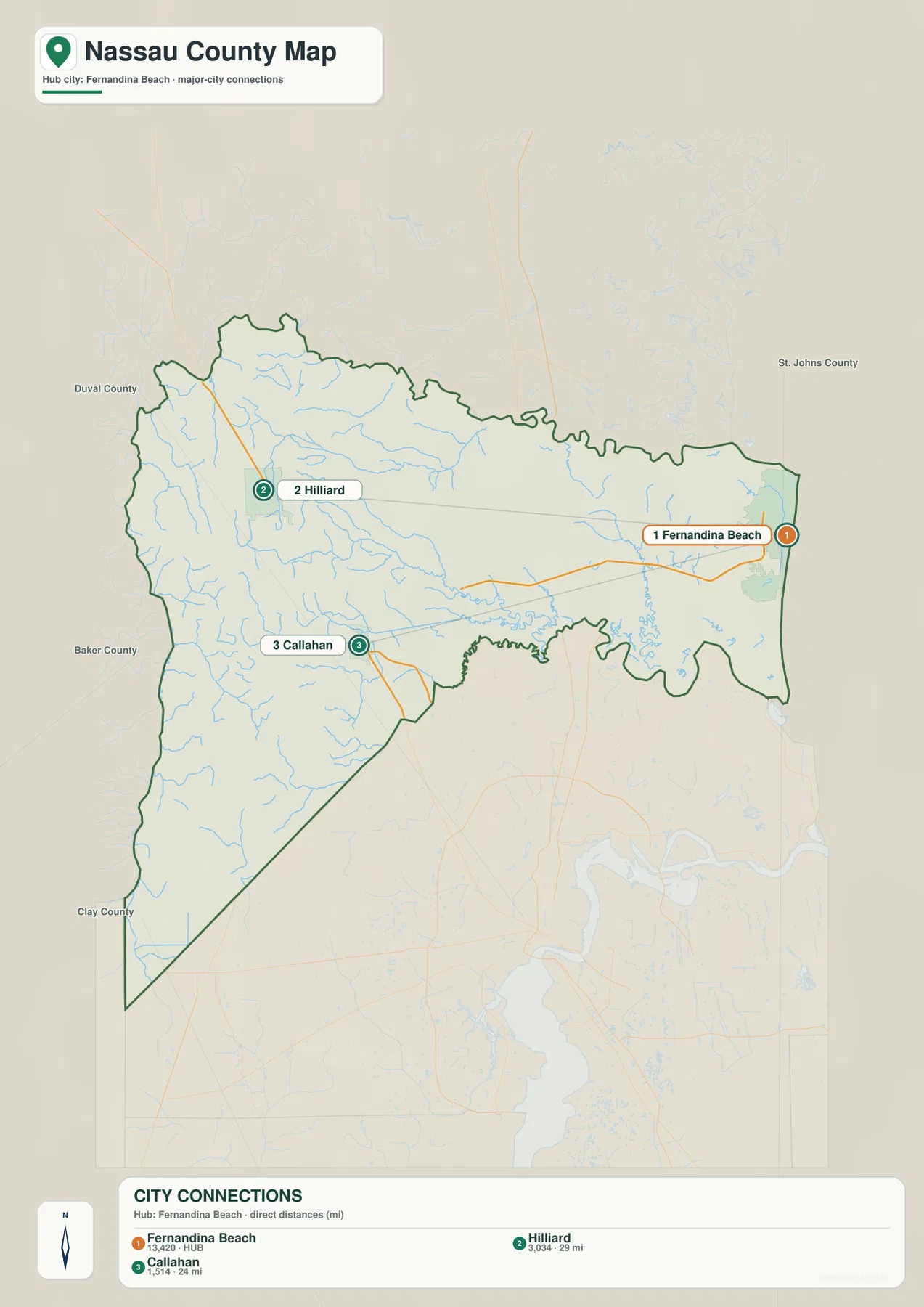
The city map is helpful because it separates incorporated municipalities from other important place names. Fernandina Beach, Hilliard, and Callahan are ranked on the map, while Yulee does not appear in the same city ranking because it is unincorporated. That does not make Yulee less important for navigation. It simply means the general county map and the city map are answering slightly different questions: one emphasizes recognizable places and road orientation, while the other emphasizes incorporated communities.
The St. Marys River turns the Georgia line into a winding boundary
Nassau County’s northern edge does not look like a straight survey line because much of it follows the St. Marys River. On the water map, the river winds eastward along the Florida-Georgia boundary, receiving smaller streams such as the Little St. Marys River before reaching the coast. The opposite bank is in Georgia, so the river is the clearest feature to follow when you want to understand where Florida ends along the north side of the county.
Near the coast, the water pattern becomes more complicated. The St. Marys River reaches the inlet north of Amelia Island, and the Bells River and Amelia River appear close by. These tidal channels and marshes separate the island from the mainland and help explain the shape of the Fernandina Beach area. Fort Clinch at the north end of Amelia Island is a useful geographic reference because Atlantic shoreline, the St. Marys Inlet area, and the Amelia River side of the island are all close together.
The Nassau River and marshes shape the southeastern side
The Nassau River is the other major water feature that stands out on the county map. Smaller inland streams feed toward the southeastern part of the county, and the river continues through a broad marsh system toward Nassau Sound. Mills Creek and Lofton Creek are among the labeled tributary or connecting waterways visible on the water map. Together they show that southeastern Nassau is not a simple dry-land edge; it is a transition from inland streams to tidal marsh and coastal water.
This matters for both geography and travel. Roads must cross or work around wide marshes and channels, so direct-looking routes on a small map can be interrupted by water. The southern end of Amelia Island, Nassau Sound, and the marshes toward northern Duval County are especially good examples. A water map makes those relationships much clearer than a road-only view because it shows why bridges and a limited number of crossings control movement near the coast.
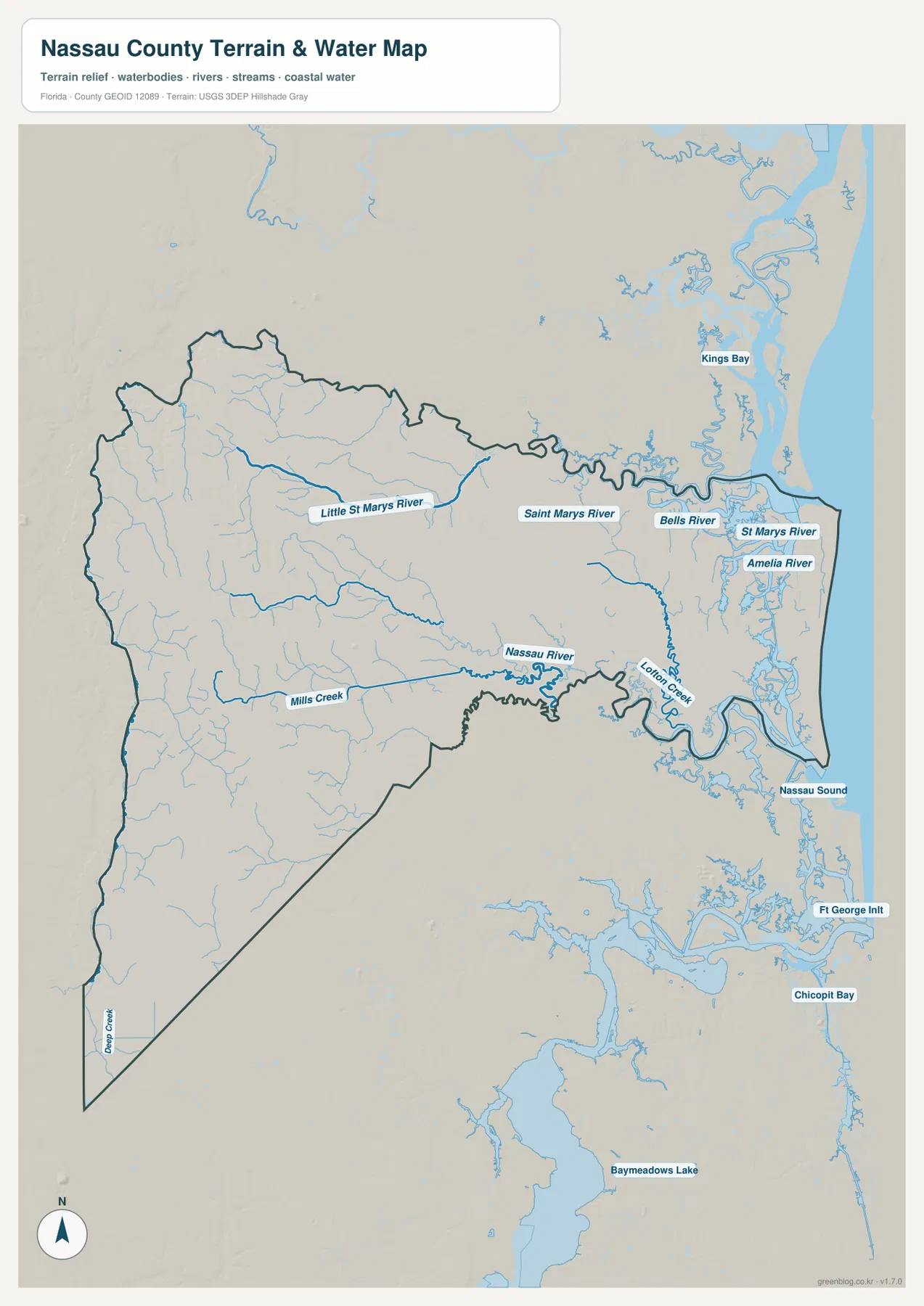
Reading all three maps together reveals a useful pattern. The county map gives the complete boundary and road context, the city map makes the relative positions of Fernandina Beach, Hilliard, and Callahan easy to compare, and the water map explains the river and marsh boundaries that a city map cannot show. The same county therefore looks different depending on whether your main question is where a town lies, how to drive across the county, or how rivers and tidal water define its edges.
Frequently Asked Questions
Is Yulee an incorporated city?
No. Yulee is a census-designated place and an unincorporated community. Its position near I-95, U.S. 17, and SR 200/A1A, together with county offices and commercial growth, nevertheless makes it one of the most important map references in Nassau County.
Which road connects I-95 with Amelia Island?
Use I-95 Exit 373 and follow SR 200/A1A east through Yulee. The route crosses the Amelia River onto the island; Fernandina Beach is then reached by continuing toward the island’s northern end.
What forms Nassau County’s boundary with Georgia?
The St. Marys River forms the northern state boundary. It flows east toward St. Marys Inlet between the north end of Amelia Island and Georgia’s Cumberland Island.
Which route is easiest to follow from I-95 toward Amelia Island?
SR 200/A1A is the key east-west route to follow on the map. It passes through the Yulee area and continues across the Amelia River toward the island. For Fernandina Beach, this route provides the clearest map connection between the interstate corridor and the coast.
Map File Information
The ZIP below contains the Nassau County general map, city map, and water map as high-resolution A3 JPG files.
- Included Files: county map JPG, city map JPG, water map JPG
Related Maps
- Arcadia Roads and Peace River | DeSoto County Florida Map
- Baker County Florida Map
- Between the Aucilla and Withlacoochee: Madison County Florida Map
Sources and References
- U.S. Census Bureau: Nassau County QuickFacts – county background and administrative reference.
- Nassau County official website – county districts and local reference.
- Florida Department of Transportation: I-95 exit information – interstate and local-road access reference.
- Florida State Parks: Fort Clinch beaches – Amelia Island’s northern shoreline setting.
- USGS National Hydrography – river and waterway reference.
Green Map creates custom-edited map images using open geographic data sources such as geoBoundaries, Natural Earth, OpenStreetMap, and government open data.
These maps are edited visual materials, not raw data files, and are provided for education, documents, presentations, and graphic reference.