You can download the general county, city, water, and elevation maps for Carter County on this page as high-resolution A3 JPG files in one ZIP archive. Carter County occupies a striking corner of northeastern Tennessee where the broad Elizabethton valley gives way to much higher mountain country toward Roan Mountain and the North Carolina line. The general map places Elizabethton in the western-central part of the county, with Watauga to the northwest, Hampton to the south, Butler near Watauga Lake, and Roan Mountain farther into the high terrain. Roads do not form a simple grid here; they follow stream valleys, curve around ridges, and squeeze through narrow mountain corridors. The sections below use the supplied maps to explain how those settlements, routes, rivers, and elevation changes fit together.
The county becomes easier to understand when the settlements are read together with water and relief. SR 91 runs northeast from the Elizabethton area through a long valley crossed by many tributaries. US 321 and SR 67 approach the Watauga Lake area, while US 19E and SR 37 lead south from Hampton toward the higher country around Roan Mountain. The western side has a denser mix of communities and roads, whereas the northeast and south contain longer stretches of mountainous terrain. Comparing the four supplied maps shows why these differences appear and prevents the county from looking like an empty outline filled with disconnected road numbers.
Table of Contents
Start with Elizabethton to understand the road framework
Elizabethton is the clearest first reference on the general county map. It sits in a broad developed area in the western-central county, close to the Carter County Courthouse and near several routes that spread in different directions. Watauga and the Johnson City side lie to the northwest. Hunter and the long SR 91 corridor extend toward the northeast. Valley Forge and Hampton form the route south, where US 19E and SR 37 continue toward the Roan Mountain section. Using Elizabethton as the anchor makes the outer communities easier to place without turning the map into a list of names.
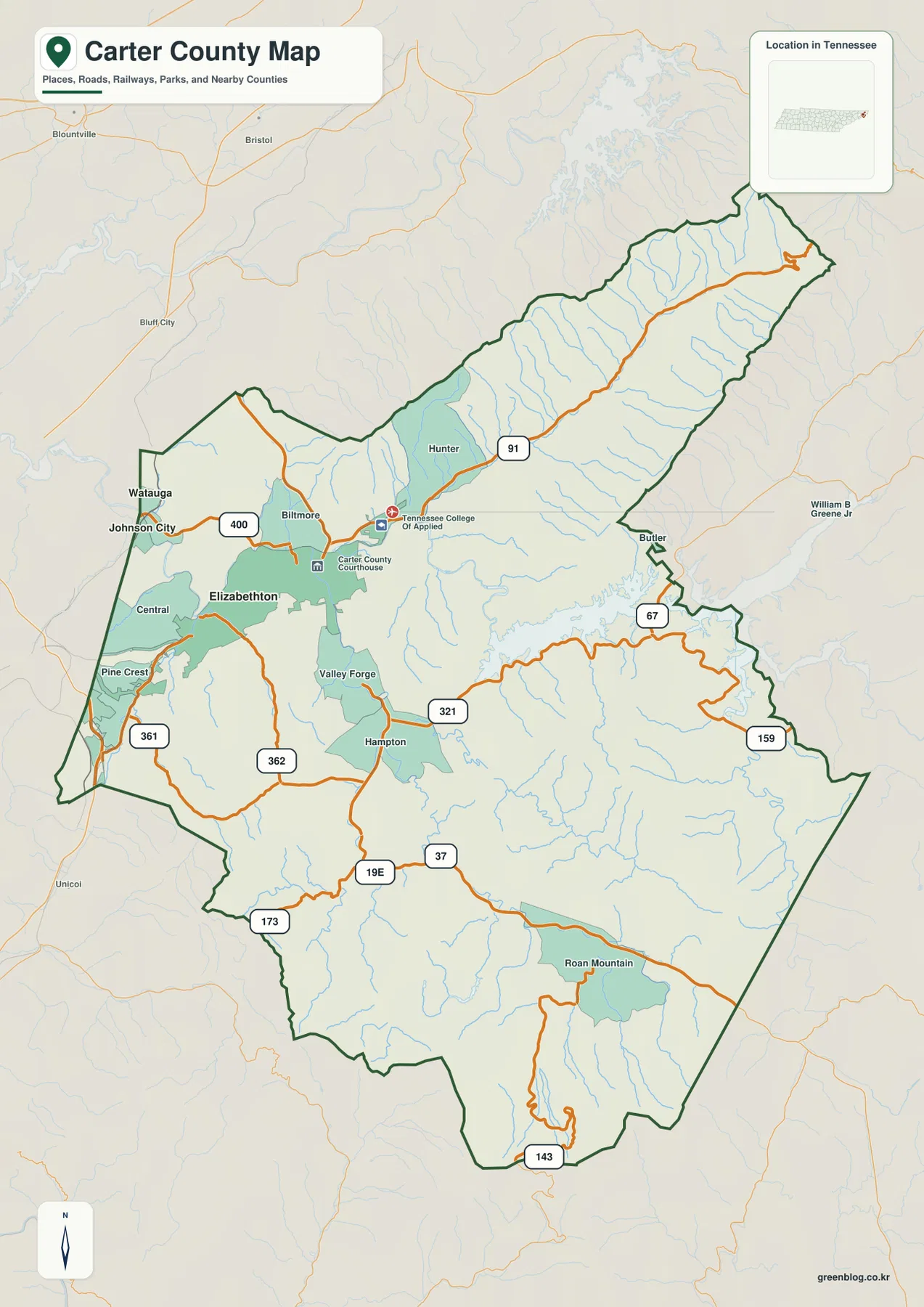
The northeastern arm of Carter County looks very different from the Elizabethton area. SR 91 follows an elongated valley with closely spaced side streams descending from both sides. In the southeast, Butler sits near Watauga Lake where US 321 and SR 67 negotiate a more complicated mix of reservoir shoreline and mountain slopes. Farther south, SR 159 and US 19E cross the higher interior, and SR 143 reaches the southern edge below the Roan Mountain area. The road map therefore works best when each route is tied to the valley or mountain setting that shapes it.
The western edge contains a tighter cluster of labels, including Watauga, Central, Pine Crest, and the larger Elizabethton area. From there the county meets the Washington County and Unicoi County sides, while the north and northeast face Sullivan County and Johnson County. The southeastern edge continues toward the North Carolina mountains. Roads, streams, and named communities do not stop simply because the county line appears on the page, so the heavy boundary should be checked before assigning an edge label to Carter County or tracing a route into a neighboring jurisdiction.
The city map separates Elizabethton from smaller Watauga
The city map ranks two major incorporated places. Elizabethton is shown first with 14,374 residents, while Watauga is second with 644. Their positions matter as much as the size difference. Elizabethton occupies the broad western-central valley where several routes and nearby communities come together. Watauga lies closer to the northwestern county edge and is a useful marker for the Johnson City side. The index therefore gives a quick picture of a county whose main urban focus is concentrated around Elizabethton rather than evenly spread across the mountains.
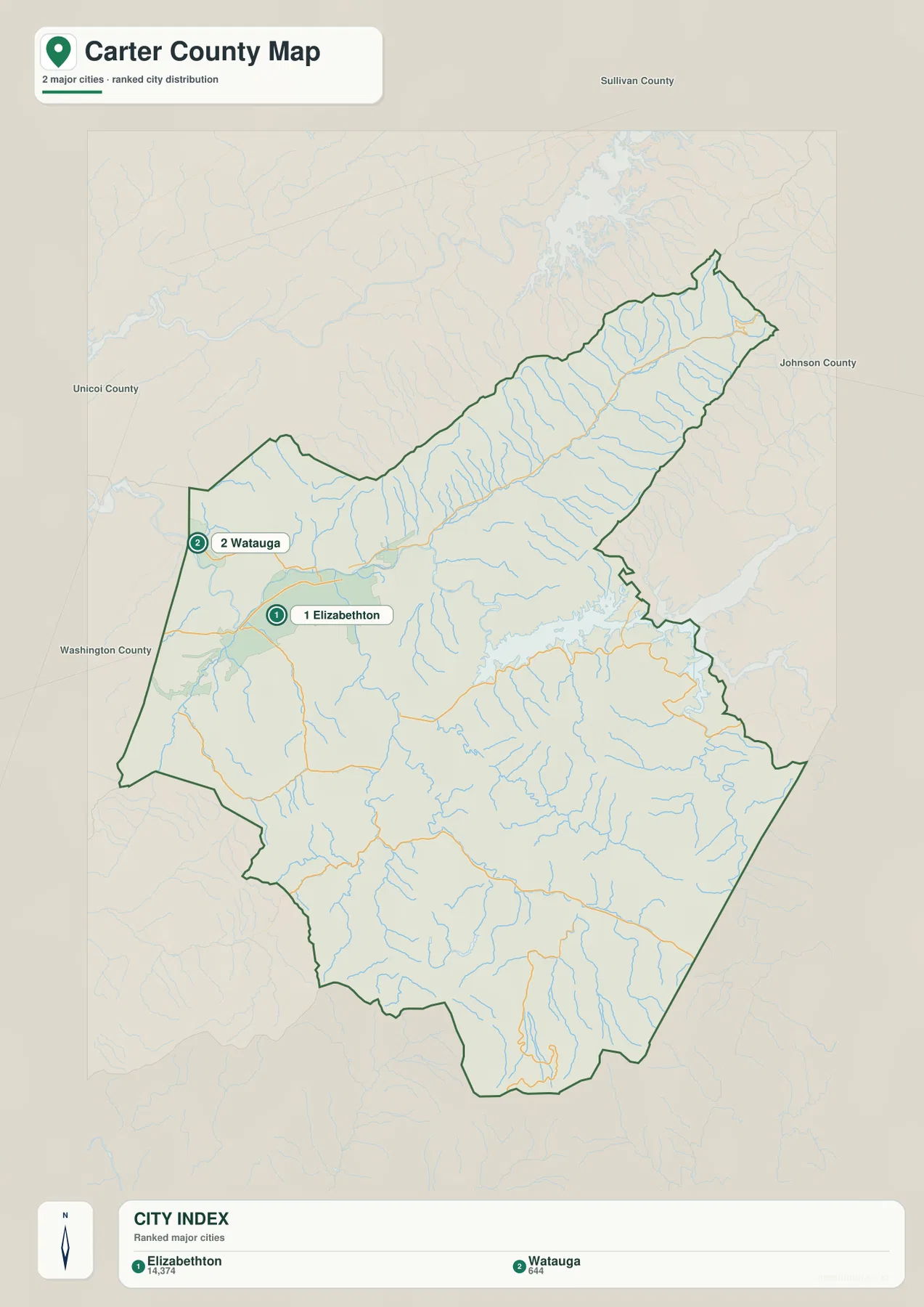
The large blank areas on the city map should not be read as empty territory. The general map adds places such as Hampton, Roan Mountain, Butler, Valley Forge, Hunter, and several smaller communities, while the physical maps show dense drainage and rugged slopes through much of the south and northeast. The city layer is intentionally selective. It is most useful for comparing the principal incorporated places, not for describing every settlement or populated valley in Carter County.
Countywide population figures provide another scale of comparison. The supplied material lists 56,356 residents in the 2020 census and a July 2025 estimate of 57,361. Census Gazetteer figures give about 341.3 square miles of land and 6.4 square miles of water. Those totals describe the size of Carter County as a whole, but they do not show the strong concentration around Elizabethton or the much more dispersed settlement pattern in the mountain valleys. That is why the city map works best when it is read beside the road and terrain images rather than treated as a complete population map.
Watauga River, Doe River, and the mountain drainage network
The water map is dominated by Watauga River and Watauga Lake across the middle and eastern part of the county. The reservoir creates a long, irregular shoreline close to the county boundary, while Watauga River continues west toward the lower Elizabethton valley. Stony Creek occupies the long northeastern corridor, and Elk River is labeled near the eastern edge. Between these larger features, dozens of smaller streams descend from the surrounding ridges, giving the map a dense branching pattern that is characteristic of steep mountain terrain.
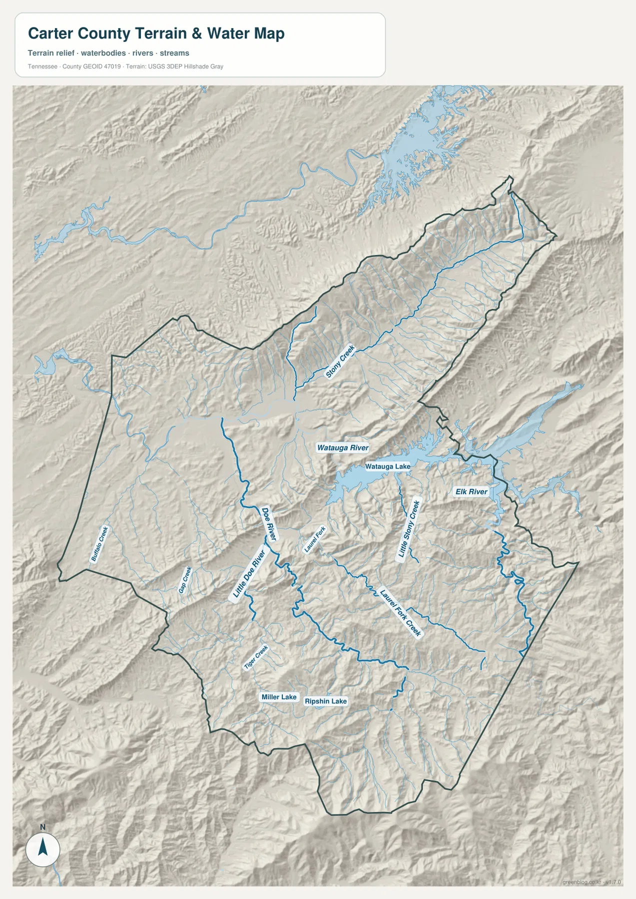
South and southwest of the Watauga system, Doe River and Little Doe River provide another important set of reference lines. Doe River runs north from the Hampton area toward the Elizabethton lowlands, while Little Doe River approaches from the east. Laurel Fork and Little Stony Creek descend through nearby mountain valleys. Farther south, Tiger Creek, Gap Creek, and Buffalo Creek appear among many smaller tributaries, and the map also labels Miller Lake and Ripshin Lake. These names show that Carter County’s water geography is much broader than the reservoir alone.
Several road patterns make more sense when this drainage is visible. US 19E and SR 37 use the same general north-south valley system as Doe River between Hampton and the Elizabethton area. SR 91 follows the Stony Creek corridor through the northeast. Around Watauga Lake, US 321 and SR 67 bend through terrain where the reservoir and steep ridges leave fewer direct route choices. The water image is not a live navigation or flood-status map, but it is very effective for explaining why roads and settlements occupy particular valleys.
A countywide elevation range from about 393 to 1,911 meters
The elevation map provides the strongest visual contrast in the set. Its note gives an actual elevation range of roughly 393 to 1,911 meters and a mean near 808 meters. Dark green marks the lower Elizabethton and Watauga River corridors, while yellow and brown tones cover the much higher ridges of the northeast, south, and southeast. The difference is large enough that Carter County cannot be described simply as a rolling upland. It contains low river valleys and very high mountain terrain within one relatively compact boundary.
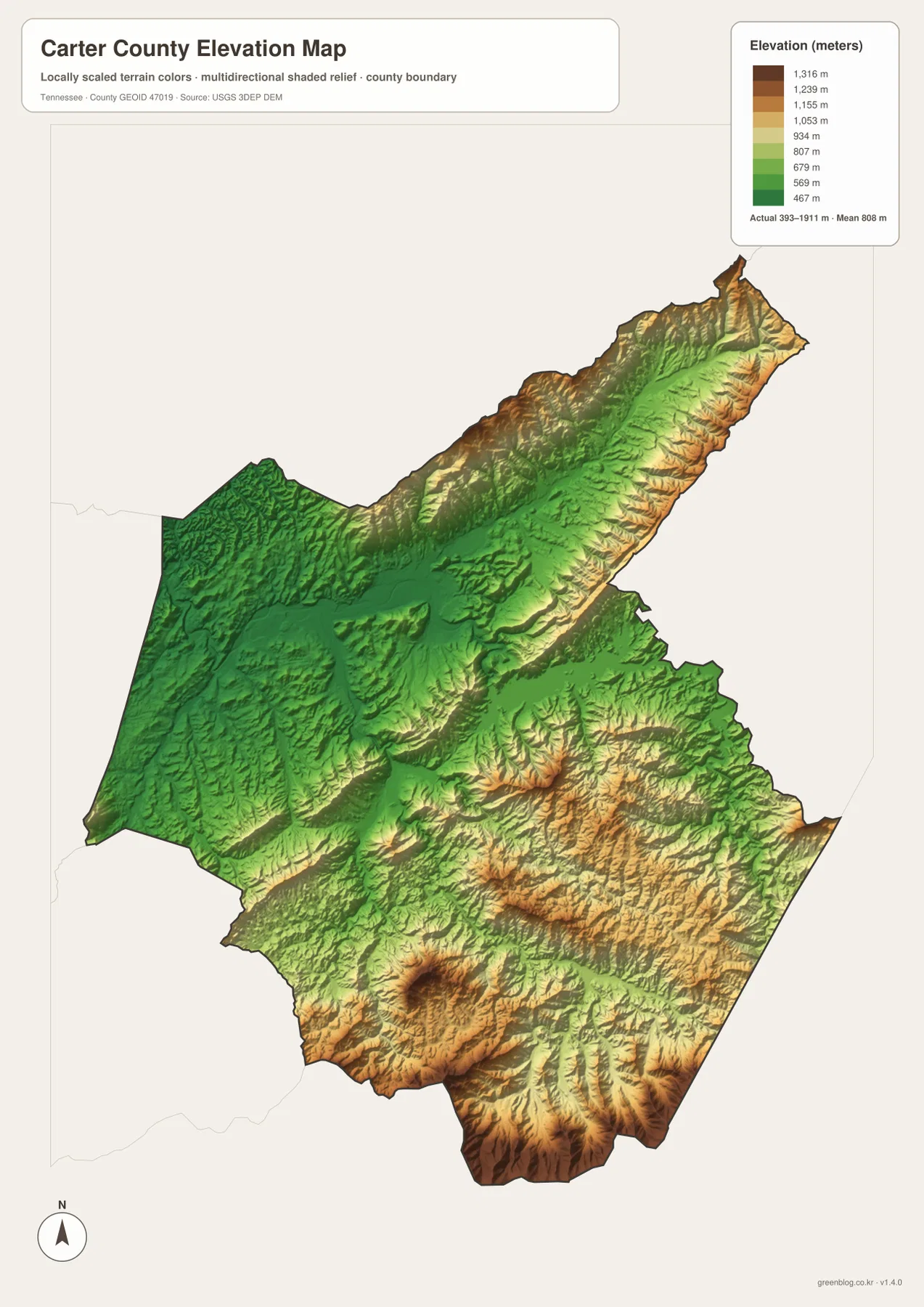
The northeast has an especially clear valley-and-ridge form. A long green corridor runs between higher slopes, matching the drainage seen around Stony Creek. In the south, the terrain rises markedly beyond Hampton toward Roan Mountain, and the darkest high-elevation colors appear close to the southern county edge. Watauga Lake occupies a lower corridor in the east, but steep ridges press close to both sides of the reservoir. This combination of water and relief helps explain why the lake shoreline is complex and why nearby roads curve so sharply.
Relief also helps explain the settlement pattern. Elizabethton has more room for a dense street and community network in the lower western valley, while the southern and northeastern sections contain narrower corridors separated by ridges. Hampton occupies a transition point before the terrain becomes much higher to the south. The elevation image is designed for county-scale comparison, so it should not be used to assign an exact elevation to a house, parcel, trail point, or construction site. For regional explanation, however, the contrast between valley floors and high ridges is immediately useful.
Reading roads, water, and relief as one connected landscape
A practical way to read Carter County is to trace outward from Elizabethton and watch the landscape change. To the northwest, the map stays within the broader lower valley toward Watauga and the Johnson City side. To the northeast, SR 91 and Stony Creek share a long mountain corridor. To the southeast, Watauga Lake, US 321, and SR 67 occupy a narrow zone between water and steep ridges. To the south, Hampton marks the entrance to a higher valley system that continues toward Roan Mountain along US 19E and SR 37.
This comparison turns community labels into part of a geographic sequence rather than isolated dots. Elizabethton sits near the meeting of low ground, roads, and the Watauga and Doe river systems. Hampton is positioned where the southern mountain corridor narrows. Butler provides a reference beside Watauga Lake, and Roan Mountain identifies the much higher southern setting. The pattern visible across all four maps is a concentration of settlement and transportation in the usable valleys, with ridges and high slopes separating those corridors.
The county boundary adds another layer to that pattern. Carter County meets neighboring Tennessee counties along the west, north, and northeast, while its southeastern side reaches the North Carolina mountain region. A road or stream may cross that administrative line while the valley itself continues uninterrupted. For regional travel or watershed study, neighboring maps should therefore be consulted as well. For county administration, classroom labeling, or a local overview, the heavy Carter County outline keeps the communities and physical features tied to the correct jurisdiction.
Choose the map that matches your Carter County question
The general county map is the strongest choice for locating Elizabethton, Hampton, Butler, Roan Mountain, Watauga, and the main highway corridors on one page. The city map is cleaner when the task is simply to compare Elizabethton with Watauga. The water map is better for explaining Watauga Lake, Watauga River, Doe River, Stony Creek, and the dense tributary network. The elevation image is the clearest option for showing the sharp contrast between the low western valleys and the high southern or northeastern ridges. Selecting the layer that matches the question keeps printed notes and annotations from becoming overcrowded.
For a clear printed workflow, use separate copies for separate themes. A route copy can highlight the connections from Elizabethton toward SR 91, US 321, and US 19E. A water copy can emphasize Watauga River, Doe River, Stony Creek, and the reservoir shoreline. A terrain copy can mark only the low western valley and the high mountain belts rather than covering the page with elevation numbers. These static files are best for orientation and explanation; current road conditions, trail access, boating rules, reservoir levels, or property details should be checked with the responsible agency before making a real-world decision.
Frequently Asked Questions
How do Elizabethton and Watauga differ on the city map?
Elizabethton is the large western-central city and county seat where several road corridors and nearby communities come together. Watauga is much smaller and lies close to the northwestern edge. The supplied city index lists Elizabethton at 14,374 residents and Watauga at 644. Marking both first gives a quick picture of the main urban center and the direction of the county’s northwest edge.
How are Watauga River and Doe River positioned?
Watauga River continues west from Watauga Lake toward the Elizabethton valley. Doe River approaches that same general lowland from the south through the Hampton corridor, with Little Doe River and other tributaries joining the drainage network nearby. Reading the two systems together helps explain why Elizabethton sits at an important meeting point of valleys, water, and roads.
Where is the strongest elevation contrast in Carter County?
The lower green terrain is concentrated around Elizabethton and the Watauga River corridor, while much higher yellow and brown terrain dominates the southern and northeastern mountain areas. The elevation map reports an actual countywide range of about 393 to 1,911 meters and a mean near 808 meters. The climb from the Hampton area toward Roan Mountain provides one of the clearest examples of the transition from a lower valley into the high country.
Map File Information
The ZIP contains the same county, city, water, and elevation maps shown on this page as four high-resolution JPG files in an A3 layout. The files can be used separately for road orientation, settlement comparison, water features, terrain study, classroom work, or annotations.
- Included Files: County map, city map, water map, elevation map
- File Type: ZIP containing four high-resolution JPG files
Related Maps
- Cannon County Tennessee map | Short Mountain and Stones River
- Bedford County Tennessee Map
- Bledsoe County Map
Sources and references
- Tennessee State Library and Archives – Carter County fact sheet for county history and administrative background
- Tennessee Wildlife Resources Agency – Watauga Reservoir for regional reservoir information
- U.S. Census Bureau TIGER/Line for county boundary and geographic reference data
- USGS National Hydrography for streams and water features
- USGS 3D Elevation Program for elevation data
Green Map creates custom-edited map images using open geographic data sources such as geoBoundaries, Natural Earth, OpenStreetMap, and government open data. These maps are edited visual materials, not raw data files, and are provided for education, documents, presentations, and graphic reference.