Carroll County in West Tennessee is easier to understand as a network of separate town and valley areas than as a county built around one dominant center. Huntingdon sits near the middle of the map, McKenzie is close to the northern edge, Bruceton lies to the east, Atwood and Trezevant are grouped in the west, and Clarksburg marks the southern part of the county. The maps on this page connect those settlements with the main roads, the forks of the Obion River, named lakes, and the county’s noticeable changes in elevation. The same maps are also available as high-resolution A3 JPG files in a ZIP download.
The four images are most useful when read together rather than as isolated layers. The general county map establishes Huntingdon and the road approaches to McKenzie, Bruceton, Atwood, and the southern communities. The water image shows why the west and central lowlands are cut by many branches of the Obion system, while the elevation image reveals higher hill belts across parts of the south and east. The city image then strips away much of that detail and makes the spacing among the main settlements especially clear.
Table of Contents
Roads radiating from Huntingdon across Carroll County
Huntingdon is the most useful place to begin on the county map because it lies near the middle of the jurisdiction and several mapped routes converge in or near the town. From this central point, the road pattern opens in distinct directions. Route 22 extends south toward Clarksburg, the route corridor toward McKenzie heads north and northwest, and other numbered roads connect west toward Trezevant, McLemoresville, and Atwood or east toward Hollow Rock and Bruceton. Reading the map from Huntingdon outward makes the irregular county outline much easier to follow.
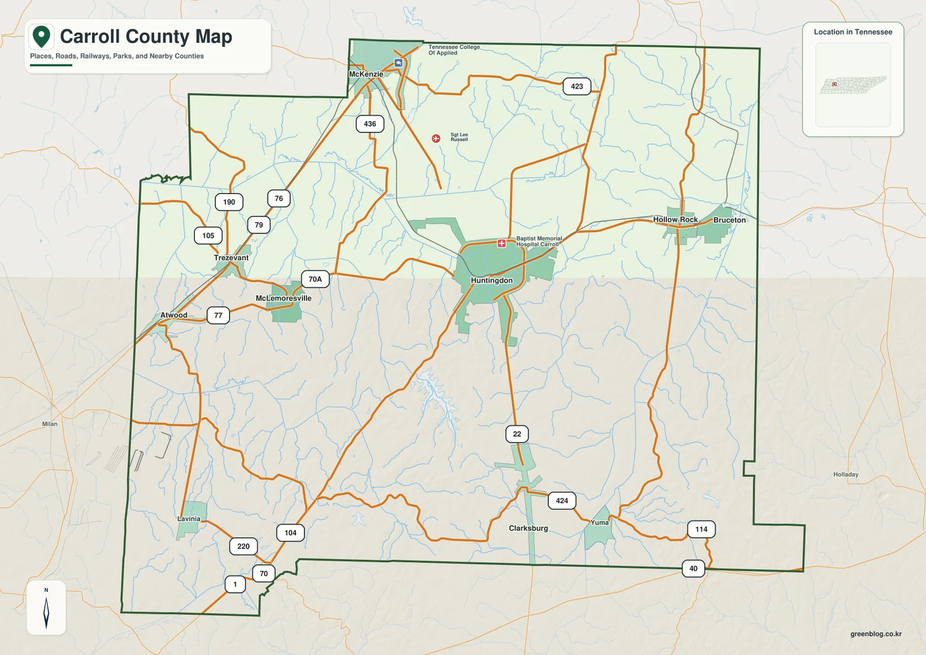
The northern side is strongly associated with McKenzie. Roads labeled 79, 76, 436, and 423 help define the approaches in that part of the county, while the western side uses labels such as 190, 105, 77, and 70A around Trezevant, Atwood, and McLemoresville. In the south, the map shows 22 through the central corridor, 424 near Clarksburg and Yuma, and 114 and 40 near the southeastern edge. The southwest has additional connections around Lavinia, including 70, 104, and 220. These labels are useful because Carroll County is broad enough that a single north-south route does not describe how its communities connect.
The county boundary also deserves attention. Carroll County is bordered by Weakley and Henry counties toward the north, Benton County to the east, Madison County toward the southeast, and Decatur, Henderson, and Gibson counties along the other sides. Several towns and road corridors sit close enough to the edge that the surrounding county names help explain where a route is headed after it leaves Carroll County. McKenzie is the clearest northern example, while Atwood and the southwestern roads make the western and southern connections more apparent.
Six mapped settlements reveal a divided town pattern
The city map ranks six principal settlements rather than treating the county as one continuous built-up area. McKenzie is listed first at 5,631, followed by Huntingdon at 4,441. Bruceton is shown at 1,431, Atwood at 1,178, Trezevant at 980, and Clarksburg at 895. These are the values printed in the city index on the supplied map, and their spatial arrangement matters as much as the ranking. The largest mapped town is near the northern edge, while Huntingdon remains the centrally placed county seat and road reference.
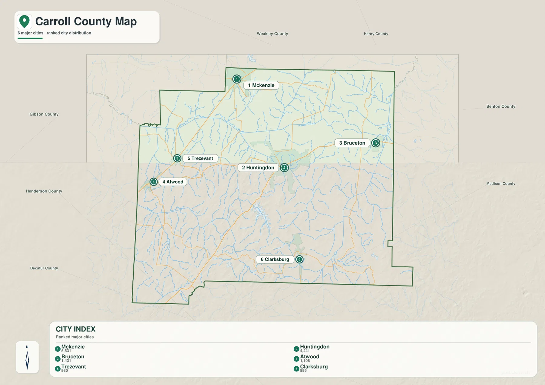
The locations form several distinct clusters. Atwood and Trezevant sit relatively close to one another in the west, but McKenzie is farther north and Huntingdon occupies a separate central position. Bruceton lies east of Huntingdon, and Clarksburg is isolated farther south. This is not the visual pattern of a county where all smaller places simply form a ring around one city. Instead, the settlement map suggests separate road-oriented pockets spread across a large rural area.
The blank space between labels should be read in combination with the physical maps. The city image intentionally emphasizes major places, while the water and elevation maps show a dense landscape of creeks, low valleys, and short ridges between them. McKenzie, Huntingdon, Bruceton, Atwood, Trezevant, and Clarksburg therefore work well as orientation points, but they do not represent every community or road in Carroll County. For a classroom map or regional article, marking those six points first creates a clean structure before additional details are added.
Obion River forks, creeks, and the recreation lake
The water map changes the visual character of Carroll County. South Fork Obion River crosses the western and northwestern part of the county, while Rutherford Fork Obion River runs through the southwest toward the central area. Smaller named streams feed those larger channels, including Reedy Creek, Brien Creek, and Johns Creek. Along the far southwestern edge, Middle Fork Forked Deer River appears near the county boundary. Rather than one major river dominating the entire county, the map shows a branching network of channels spread across multiple low corridors.
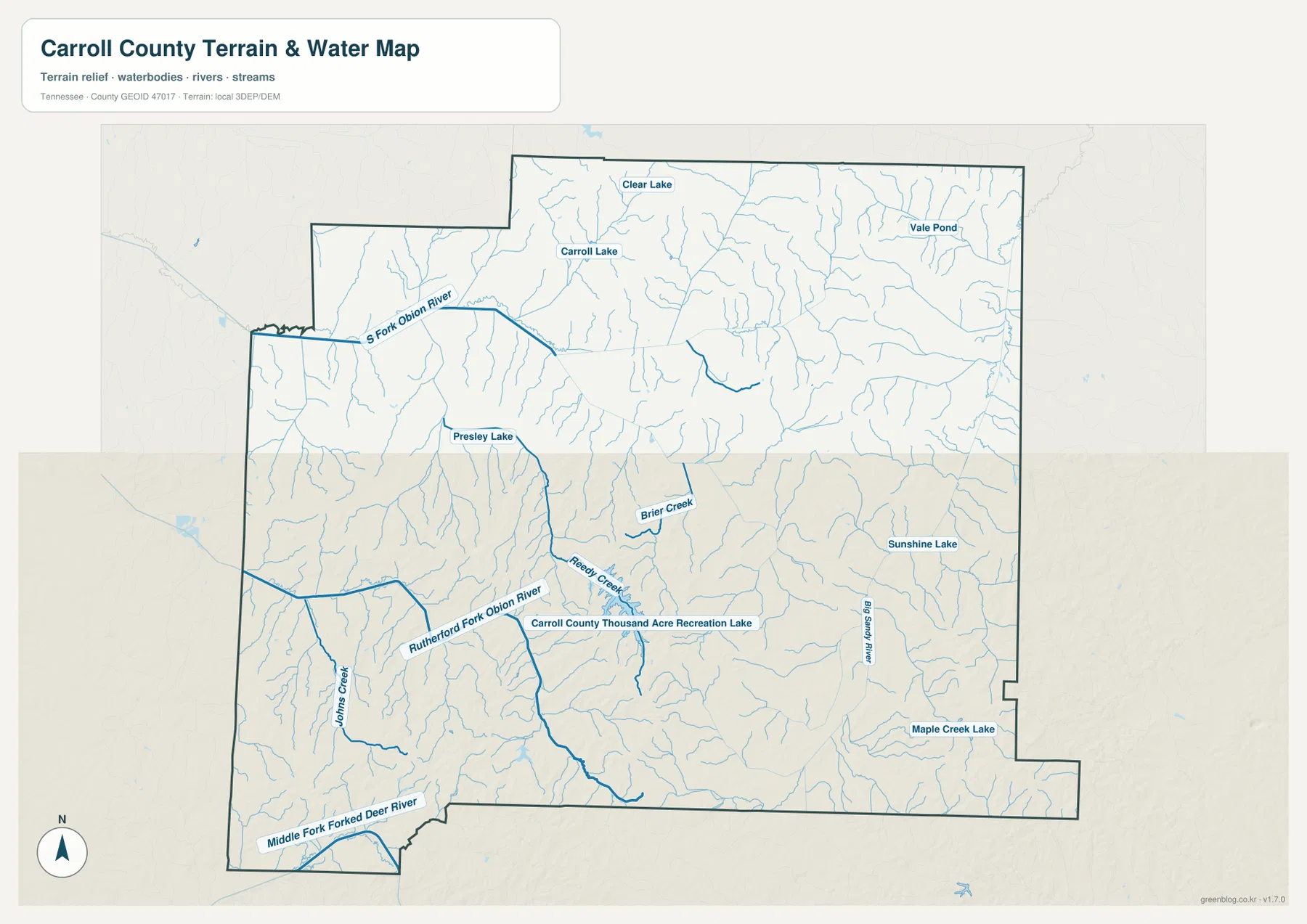
Carroll County Thousand Acre Recreation Lake is one of the strongest labeled water features in the central-southern part of the map. It sits among a group of smaller drainage lines rather than on the county edge. Other named water bodies are distributed widely: Clear Lake and Carroll Lake are in the north, Presley Lake is farther west, Sunshine Lake lies to the east, Vale Pond appears in the northeast, and Maple Creek Lake is labeled near the southeast. Their spread reinforces the idea that water is woven through several different parts of the county.
This map is designed for county-scale orientation, so its value is in relationships rather than navigation detail. It helps explain why the western settlements sit among so many stream lines, how the central road network relates to low ground, and where the recreation lake falls relative to Huntingdon and Clarksburg. It does not replace a current boating chart, flood map, bridge database, or property survey. For those tasks, the broad water pattern can be used as a starting reference before moving to a specialized source.
Low central valleys and higher hills in the south and east
Carroll County’s elevation map shows a more varied surface than the general road map suggests. The inset reports an actual elevation range of roughly 99 to 214 meters, with a mean near 141 meters. Broad green areas mark lower ground through much of the center and west, while warmer brown tones highlight higher ridges and hill groups. The strongest higher terrain appears in portions of the south-central and southeastern county, with additional ridges extending across the east and north.
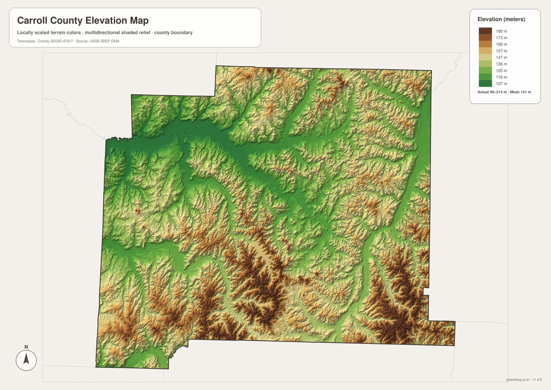
The connection with the water map is especially clear. The larger forks of the Obion system occupy elongated lower corridors, and many small tributaries trace narrow green channels between ridges. Huntingdon is surrounded by relatively lower terrain compared with several hill groups to the south. The McKenzie area combines low corridors with nearby ridges, while the southern portion around and east of Clarksburg shows a rougher pattern of short, repeated hills. These differences help explain why some roads hold long valley alignments and others bend repeatedly through the terrain.
The elevation image is best used for relative comparison. It can show which sections of Carroll County are generally higher, where major valleys cut across the landscape, and how terrain changes between the central towns and the southern edge. It is not precise enough for engineering, parcel grading, or a building-site elevation. For a printed regional map, however, the contrast between green valley floors and brown hill belts gives useful physical context without requiring a long technical explanation.
What Huntingdon and McKenzie reveal when the layers are compared
Huntingdon and McKenzie provide a useful two-point comparison because they occupy different parts of the county and play different geographic roles. Huntingdon is centrally placed, surrounded by roads that spread toward the west, north, east, and south. McKenzie sits much closer to the northern edge and works as a gateway toward the Weakley County side. The city index also ranks McKenzie above Huntingdon by the population figure printed on the map, which makes it a good reminder that the largest mapped settlement and the county seat do not have to be the same place.
The physical layers add another distinction. The central Huntingdon area lies within a broad set of lower corridors connected to nearby streams. The route toward McKenzie crosses a landscape of tributaries and modest ridges before reaching the northern town. To the west, Atwood and Trezevant occupy another stream-rich zone near the Obion system, while Bruceton sits in a different eastern drainage setting. Clarksburg, by contrast, is closer to the more strongly shaded hills of the southern county. These differences are more informative than describing all six settlements simply as points inside one boundary.
Population and area figures provide scale without replacing the map. The 2020 census count for Carroll County is 28,440, and the July 2025 estimate listed in the supplied material is 29,200. Census Gazetteer material gives about 597.7 square miles of land and 2.4 square miles of water. Those totals explain the county’s overall size, but they do not show which communities are separated by long rural stretches or which road approaches are constrained by streams and hills. The settlement, water, and elevation images provide that missing geographic detail.
Choose the Carroll County map that matches the question
The general county image works best when the task involves Huntingdon, highway directions, the irregular boundary, or connections to neighboring counties. The city image is cleaner for comparing McKenzie with Huntingdon and the four smaller ranked settlements. The water map is the better choice for explaining the Obion River forks, Carroll County Thousand Acre Recreation Lake, and the many creeks cutting through the west and center. The elevation map is most useful when the subject is the difference between lower valleys and the hillier southern or eastern sections.
For annotation, it is often clearer to keep separate copies for separate subjects. A road copy can begin with Huntingdon and trace the approaches to McKenzie, Bruceton, Atwood, and Clarksburg. A physical-geography copy can emphasize South Fork Obion River, Rutherford Fork Obion River, the recreation lake, and the higher southern ridges. A settlement copy can use only the six ranked towns and the county boundary. Keeping the purpose narrow preserves the readability of the original image, while current navigation, parcel, access, or water-level questions can be checked with the appropriate official source.
Frequently Asked Questions
How are Huntingdon and McKenzie positioned differently?
Huntingdon is near the center of Carroll County and is the best reference for routes spreading into several parts of the county. McKenzie is near the northern boundary and serves as a clearer reference for the north and the Weakley County direction. The city index on the map lists McKenzie at 5,631 and Huntingdon at 4,441, while Huntingdon remains the county seat. Marking both first gives a quick sense of Carroll County’s north-to-center layout.
Where is Carroll County Thousand Acre Recreation Lake on the water map?
The recreation lake is labeled in the central-southern portion of the county, south of the Huntingdon area and among several smaller drainage lines. Rutherford Fork Obion River lies farther west, while other named lakes are spread across the north, west, east, and southeast. The map is useful for regional orientation around the lake, but current access, fishing, and operating information should be checked with the Tennessee agency responsible for the site.
Which parts of Carroll County appear highest on the elevation map?
The strongest higher-ground colors are concentrated in parts of the south-central and southeastern county, with additional ridges across the east and north. Lower green corridors are more extensive through the center and west, especially around major stream valleys. The map reports an actual range of about 99 to 214 meters and a mean near 141 meters, making it suitable for comparing broad terrain differences across the county.
Map File Information
The download contains the same county, city, water, and elevation maps shown on this page as four high-resolution JPG files in an A3-format ZIP. Use the individual file that best fits a road, settlement, water, terrain, classroom, or annotation task.
- Included Files: County map, city map, water map, elevation map
- File Type: ZIP containing four high-resolution JPG files
Related Maps
Sources and references
- Tennessee State Library and Archives – Carroll County fact sheet for county background
- Tennessee Wildlife Resources Agency – Carroll Lake for regional water information
- U.S. Census Bureau TIGER/Line for county boundary and geographic data
- USGS National Hydrography for mapped streams and water features
- USGS 3D Elevation Program for elevation data
Green Map creates custom-edited map images using open geographic data sources such as geoBoundaries, Natural Earth, OpenStreetMap, and government open data. These maps are edited visual materials, not raw data files, and are provided for education, documents, presentations, and graphic reference.