Turner County is a rural county in southeastern South Dakota where small towns are separated by broad stretches of farmland and connected by a handful of state highways. Parker sits near the northern interior, Marion lies to the west, and Viborg and Centerville form a second group farther south. Across the eastern half of the county, the Vermillion River and its branches cut through lower ground. The maps on this page are useful because they place those towns, roads, waterways, and elevation differences in the same county outline. The original A3 high-resolution JPG versions of all four maps are available together in the ZIP download below.
According to U.S. Census Bureau QuickFacts, Turner County contains 617.06 square miles of land and had 8,673 residents in the 2020 Census, or 14.1 people per square mile. That relatively low density is visible on the map: communities remain distinct rather than merging into a continuous urban area. The official Turner County website identifies Parker as the county government center while county services extend across places such as Marion, Hurley, Centerville, Monroe, Davis, and the surrounding rural area. For orientation, the most useful way to read Turner County is therefore to combine town locations with the road and river networks that connect them.
Table of Contents
The county splits naturally into a Parker-Marion north and a Viborg-Centerville south
Parker is near the north-central part of Turner County, with Marion to the west and Monroe farther north. Chancellor sits east of Parker. South of Parker, the map places Hurley first and Viborg farther down, while Centerville occupies the southeastern end of the county. Davis is north of Centerville, Irene is near the southern boundary to the west, and Cameron Colony appears in the southwest. The towns are not arranged around a single compact center, so the countywide view is more informative than a city-by-city list.
The southern boundary also has a pronounced inward step. That shape makes the positions of Irene, Viborg, and Centerville easier to understand visually: Viborg is near the south-central section, Centerville extends farther east, and Irene lies closer to the southwestern side. In the north, Parker and Marion sit much closer to one another than either does to Viborg. The map therefore shows two broad settlement groupings separated by a substantial rural interval.
SD 44 links Marion and Parker, while SD 19 and SD 18 shape the southern network
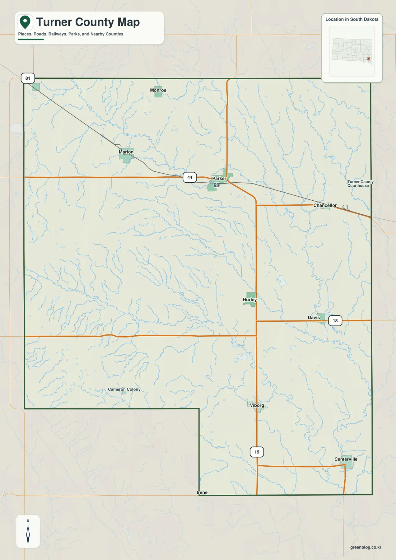
South Dakota Highway 44 is the most obvious east-west road across the northern part of the county. It connects the Marion-Parker corridor and continues toward Chancellor. From Parker, southbound roads lead toward Hurley and Viborg, where SD 19 becomes an important north-south route. SD 18 crosses the southern portion near Davis, and a US 81 marker appears near the northwestern edge. Together these roads show that Turner County has separate northern and southern travel patterns rather than one single highway running through every major town.
A railroad line also crosses the northern part of the county near Marion, Parker, and Chancellor. That alignment reinforces the importance of the northern east-west corridor. Farther south, Viborg and Centerville depend more visibly on state and local roads. The map is not a navigation product and should not be used for current closures or driving-time estimates, but it is a useful reference for seeing which communities are closest to the main routes.
The route from Parker toward Centerville illustrates the county’s layout well. Travel shifts south through the Hurley-Viborg area before turning toward the southeast, rather than following one straight central line. Marion and Parker belong to the stronger northern corridor, while Viborg and Centerville sit within a different set of connections. That distinction becomes clear on the general map and helps explain why the towns should not be treated as one continuous chain.
Six ranked towns show how widely Turner County’s communities are spread
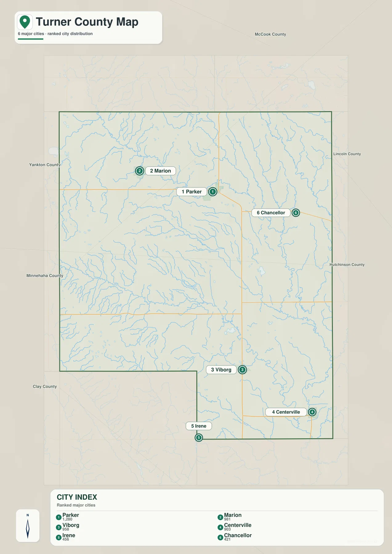
The city layer numbers six selected communities and displays index values of 1,280 for Parker, 981 for Marion, 958 for Viborg, 903 for Centerville, 456 for Irene, and 421 for Chancellor. These are the values used in the supplied map’s ranking layer and should not automatically be treated as the latest population estimates. The main benefit of the city map is visual simplicity: it removes much of the road and settlement detail and makes the six locations easy to compare.
Parker and Marion are concentrated in the north, but Viborg is much farther south. Centerville sits in the southeast, Irene near the southwestern part of the southern boundary, and Chancellor east of Parker. Even the three highest indexed places do not form a single cluster. That geographic separation is the most important message of the city layer. For places such as Monroe, Hurley, and Davis, which are not numbered here, the general county map provides the broader context.
The ranking should also be kept separate from civic function. Parker is the county seat because of its government role, not because it carries the number-one marker on this particular map. Current population comparisons should come from Census or local data. Use this layer when the goal is simply to compare the relative positions of selected towns within Turner County.
The Vermillion River is built from two major forks and many smaller creeks
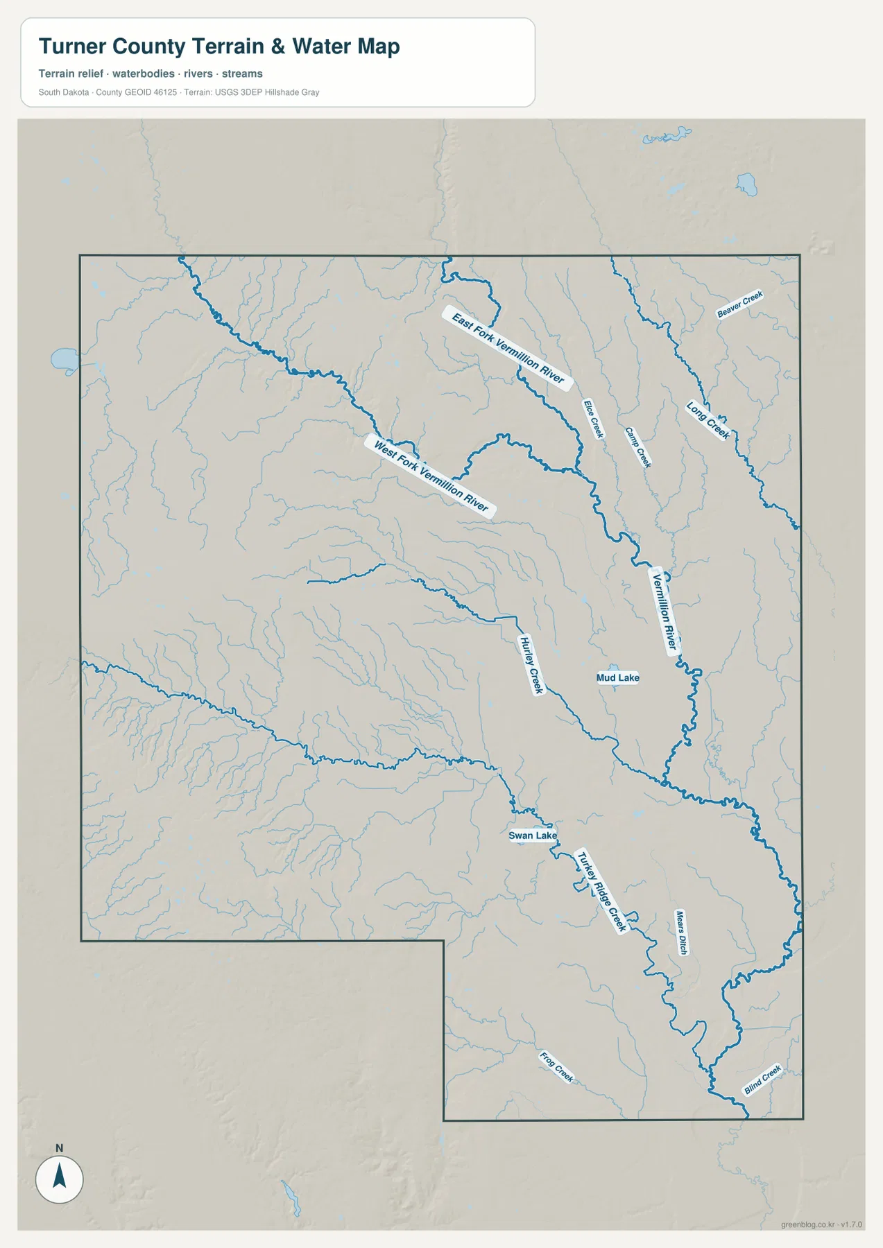
The water map changes the way the county looks. The West Fork Vermillion River enters from the west and bends across the northern interior, while the East Fork Vermillion River descends from the north. The two branches approach the main river corridor in the north-central portion of Turner County, and the Vermillion River then continues across the eastern half toward the southeast. This branching system is one of the clearest physical features in the county.
Several smaller waterways feed the river. Long Creek, Beaver Creek, Camp Creek, and Elce Creek are labeled in the northern and eastern sections. Hurley Creek and Turkey Ridge Creek appear farther south, with Blind Creek in the southeast. Swan Lake and Mud Lake provide additional reference points. The eastern and central parts of Turner County therefore contain a noticeable network of named channels, while the western side is broken by smaller tributaries and shallow valleys.
This map shows location and terrain relationships only. It does not provide flood probabilities, current streamflow, water quality, property boundaries, legal access, or drainage rights. Those questions require current USGS, state, or local information. For geographic study, however, the water map is particularly useful when placed beside the elevation map because the main river channels occupy visibly lower ground.
A 361–530 meter elevation range separates the southwest uplands from lower river corridors
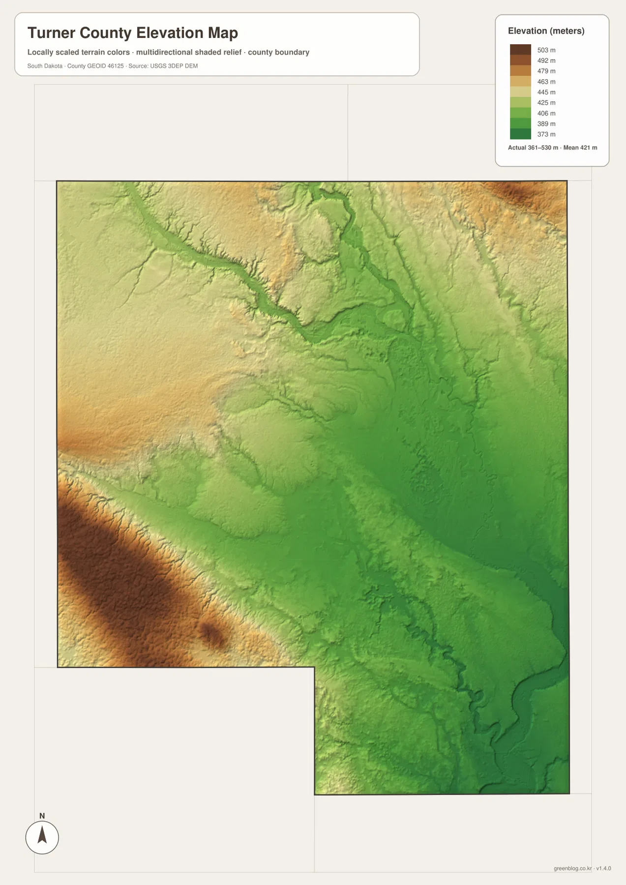
The elevation legend gives an actual mapped range of roughly 361 to 530 meters, with a mean near 421 meters. The strongest brown tones occupy the southwest, with some additional higher ground on the western side and near the far northeast. Lower green terrain dominates much of the central and eastern interior. The contrast is modest compared with mountainous western South Dakota, but it is large enough to show that Turner County is not completely flat.
The lowest strips often follow the East Fork, West Fork, and main Vermillion River channels. Those valleys cut into slightly higher yellow and tan ground, and smaller tributaries create additional narrow low areas. The southwest, by comparison, rises more broadly. Looking at the elevation and water maps together makes the relationship easy to see: the river network occupies lower terrain while the southwest stands higher and more continuous.
The elevation surface is a countywide reference derived from USGS 3DEP data. It is useful for comparing general relief and identifying higher and lower areas, but it is not survey-grade data. Property elevation, drainage design, construction, or detailed slope calculations require original elevation datasets and site-specific measurements.
Choose the map that matches the question you are trying to answer
For basic orientation, begin with the general county map. It places Parker, Marion, Chancellor, Hurley, Viborg, Centerville, and the major roads in one view. The city map is cleaner for comparing six selected towns. Use the water map when the East and West Forks of the Vermillion River, Swan Lake, or named creeks matter, and turn to the elevation map when the goal is to explain why the southwest is higher than the central and eastern river corridors.
The WebP images on the page are optimized for quick viewing. The ZIP archive contains the original 2572×3638-pixel JPG versions of the general county map, city map, water map, and elevation map. Those files are better for A3 printing, zooming into small labels, classroom materials, presentations, and personal geographic reference. Legal boundary decisions, surveying, flood safety, and live road conditions still require current official data designed for those purposes.
Frequently Asked Questions
Is Parker the county seat of Turner County?
Yes. The official Turner County website identifies Parker as the location of county government. That civic role is separate from the numbered ranking used on the city map, which is only a comparison layer for selected towns.
Where are the East and West Forks of the Vermillion River on the map?
The West Fork approaches from the west across the northern part of the county, while the East Fork comes down from the north. Both are labeled on the water map before the system continues through the main Vermillion River corridor. The downloadable JPG is easier to use when zooming into smaller tributary labels.
Can the elevation map be used for a property survey?
No. The 361–530 meter range is intended for broad countywide comparison. Surveying, construction, drainage, or precise site-elevation work requires original USGS 3DEP data and professional field measurements.
Map File Information
The archive contains the Turner County general map, ranked city map, water map, and elevation map as high-resolution A3 JPG files.
- Included Files: 4 JPG maps
- Printable Size: 2572×3638 pixels each
- Intended Use: Printing, education, presentations, and geographic reference
Related Maps
Sources and References
- Turner County, South Dakota: official county government and local-service information
- U.S. Census Bureau QuickFacts – Turner County, South Dakota: population, land area, and density reference
- South Dakota Department of Transportation – Maps: official state and county transportation map resources
- U.S. Census Bureau TIGER/Line Shapefiles: official boundary and geographic data
- USGS National Hydrography: river, lake, and stream reference data
- USGS 3D Elevation Program: elevation-data reference for the county elevation map
Green Map creates custom-edited map images using open geographic data sources such as geoBoundaries, Natural Earth, OpenStreetMap, and government open data.
These maps are edited visual materials, not raw data files, and are provided for education, documents, presentations, and graphic reference.