You can download the Lumpkin County Map files from this page as one ZIP containing four original high-resolution A3 JPGs. Lumpkin County sits in the mountains of north Georgia, with Dahlonega serving as the county seat and the clearest urban reference point on the supplied maps. The county boundary encloses a landscape of ridges, narrow valleys, dense creek networks, and a road system that converges on Dahlonega before spreading toward neighboring counties. The four map views connect those features so readers can compare roads and settlements with the county’s waterways and mountain relief.
The maps are most useful when they are read as a set rather than as four versions of the same picture. The county map gives the quickest view of boundaries, roads, labeled places, and streams. The city map strips the settlement pattern down to its strongest feature: Dahlonega is the one ranked major city shown. The water map makes the Chestatee and Etowah river systems much easier to follow, while the elevation map shows how strongly the northern and northwestern ridges rise above the lower valleys farther south.
That contrast is important in Lumpkin County. A visitor looking only at a road map might see a compact county centered on Dahlonega, but the water and elevation maps reveal a much more rugged setting. Creeks branch through nearly every part of the county, the highest terrain is concentrated toward the north, and many roads follow the easier passages between ridges. The sections below use the map labels and verified county sources to explain those relationships without treating the maps as parcel, flood, navigation, or engineering products.
Table of Contents
Dahlonega Anchors the County’s Road and Boundary Map
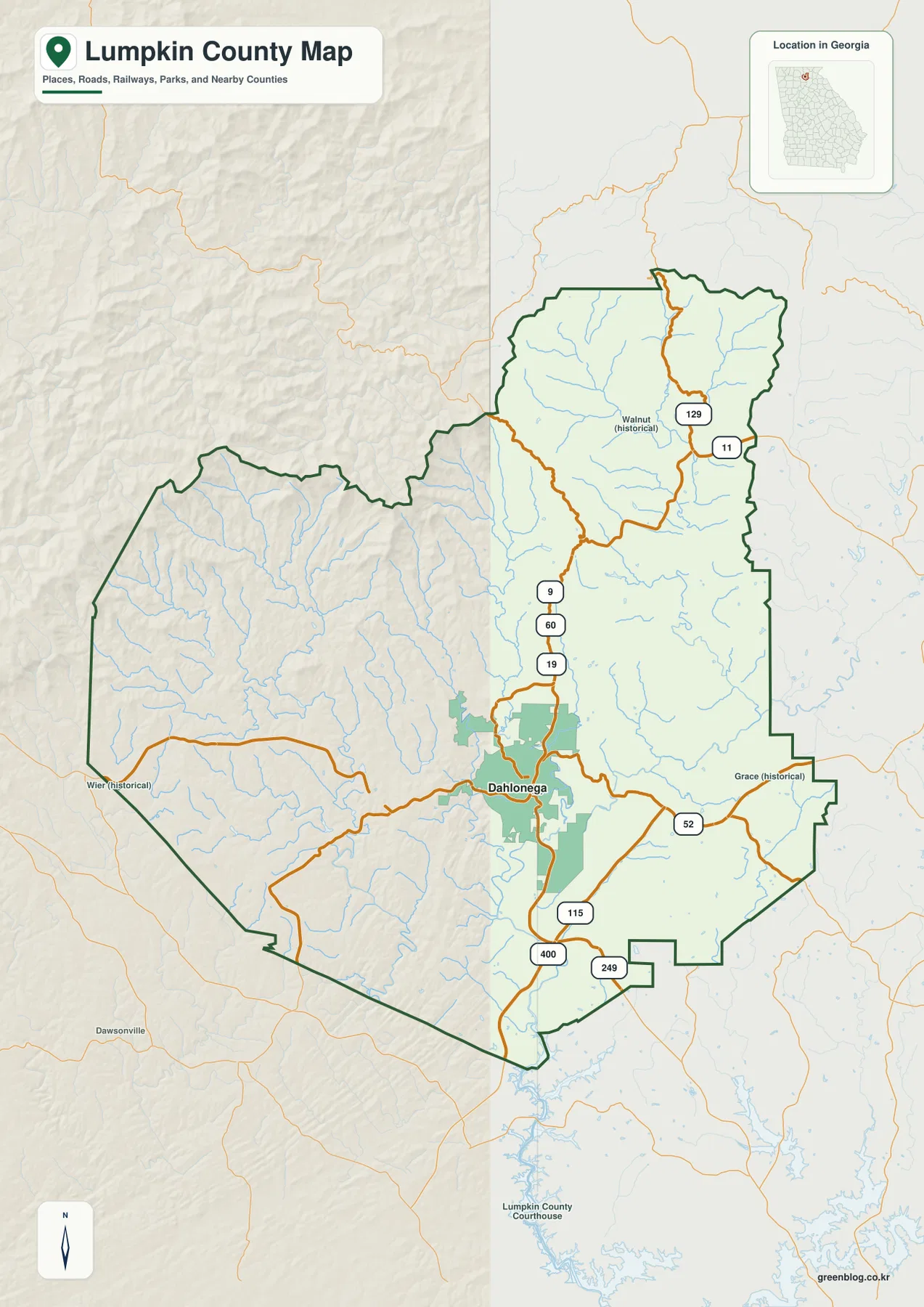
Dahlonega is the dominant label near the center of the southern half of the county map. U.S. 19 and Georgia routes 9 and 60 run through the Dahlonega area and continue toward the mountain country to the north and the lower approaches to the south. Route 52 extends eastward, while Route 115 and the Georgia 400 corridor are visible on the southern side of the county. These roads make Dahlonega a practical starting point for understanding direction: once the city is located, the northern ridges, western mountain country, eastern river valleys, and southern approaches are easier to place.
The county outline is noticeably irregular rather than rectangular. Lumpkin County is bordered by Union, White, Hall, Dawson, Gilmer, and Fannin counties, placing it within the cluster of counties that make up the north Georgia mountain region. The map also shows a dense network of light-blue streams inside the boundary. Even before the waterways are enlarged on the dedicated water map, their abundance makes it clear that valleys and drainage lines are a major part of the county’s physical geography.
Several historical place labels, including Walnut, Wier, and Grace, appear on the reference map. Those labels are useful for orientation but should not be read as a complete list of present-day municipalities or communities. The county map is designed to establish broad geographic context. It does not contain every local street, unincorporated settlement, parcel boundary, service address, or municipal detail that would be needed for property research or turn-by-turn travel.
The City Map Shows a Strong One-City Pattern
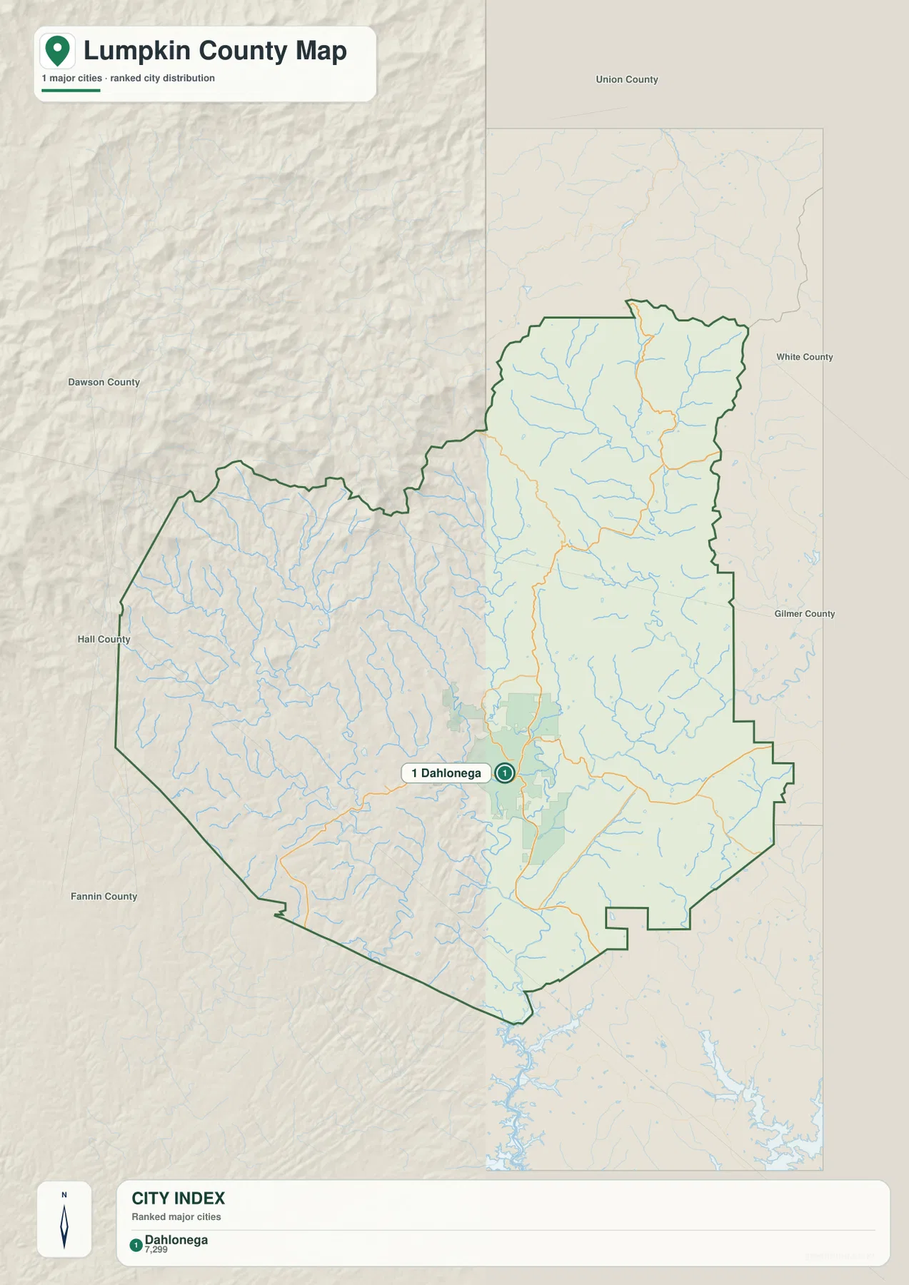
The city map is unusually simple compared with counties that contain several incorporated population centers. Its city index identifies Dahlonega as the single ranked major city, and the main map places one city marker in the Dahlonega area. That does not mean there are no other communities in Lumpkin County. It means the map is ranking major cities rather than cataloging every settlement, and Dahlonega clearly dominates that comparison.
Dahlonega is also the county seat, so its importance is administrative as well as geographic. Lumpkin County was officially established in 1832. County and New Georgia Encyclopedia histories connect the area closely to the gold discoveries that drew large numbers of people into north Georgia beginning around 1828. Dahlonega became the leading center of that gold district, and a federal branch mint opened there in 1838. The city later became home to what is now the University of North Georgia, adding an educational role to its long-standing government and tourism functions.
Reading the city map beside the road map helps explain why Dahlonega remains the best reference point for the county. Major routes converge near the city, while the terrain becomes higher and more dissected toward the north and west. In a county without several comparable urban centers, the practical question is less about measuring distances between cities and more about understanding how the main city relates to mountain roads, river valleys, and county edges. For that purpose, the single-city map is a useful simplification rather than a limitation.
Chestatee and Etowah Waters Form Two Distinct River Settings
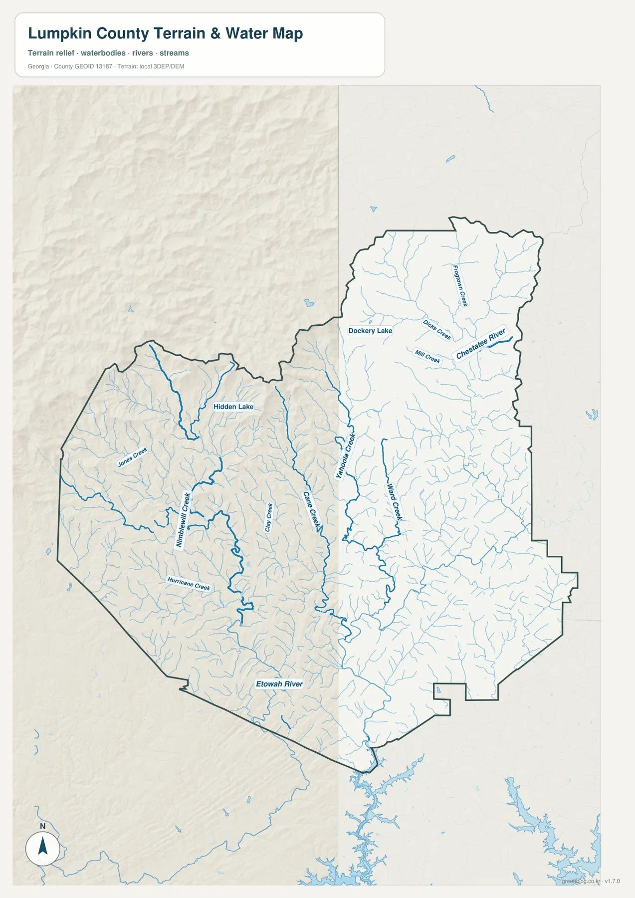
The water map is one of the most information-dense views in the package. In the northeastern part of Lumpkin County, the Chestatee River is labeled prominently, with Frogtown Creek, Dicks Creek, and Mill Creek feeding the larger system. Farther toward the center, Yahoola Creek and Cane Creek provide long, recognizable lines through the interior, while Ward Creek and many smaller tributaries fill the eastern and southeastern slopes. Removing most of the road emphasis makes these branching streams much easier to trace than they are on the general county map.
The western and southwestern side of the county has a different set of named waterways. Jones Creek, Montgomery Creek, and Hurricane Creek descend through the western mountain terrain, and the Etowah River is labeled near the southern part of that side of the county. The map therefore does not show one simple river running through the middle of Lumpkin County. Instead, the county is divided among stream networks that ultimately connect toward different larger river systems, reflecting the ridges and valleys that separate drainage directions.
Smaller named water bodies are also visible. Dockery Lake appears in the northern portion of the map, and Hidden Lake is labeled in the western interior. These features help readers move from a county-wide view to more specific local references without turning the map into a recreational navigation chart. The map does not show flood zones, water depth, boat access, legal stream boundaries, water quality, or property ownership. Those questions require specialized current sources from the responsible agencies.
The water map becomes more useful when compared directly with the elevation map. Short tributaries begin on the higher slopes and collect in lower valleys, where they join larger creeks and rivers. The abundance of branching blue lines is not random decoration; it mirrors the highly dissected mountain terrain. For general geography, this is the key relationship to notice: the ridges divide the county into many small drainage areas, and the creeks mark the lower corridors between them.
Elevation Rises Sharply Toward the Northern and Northwestern Ridges
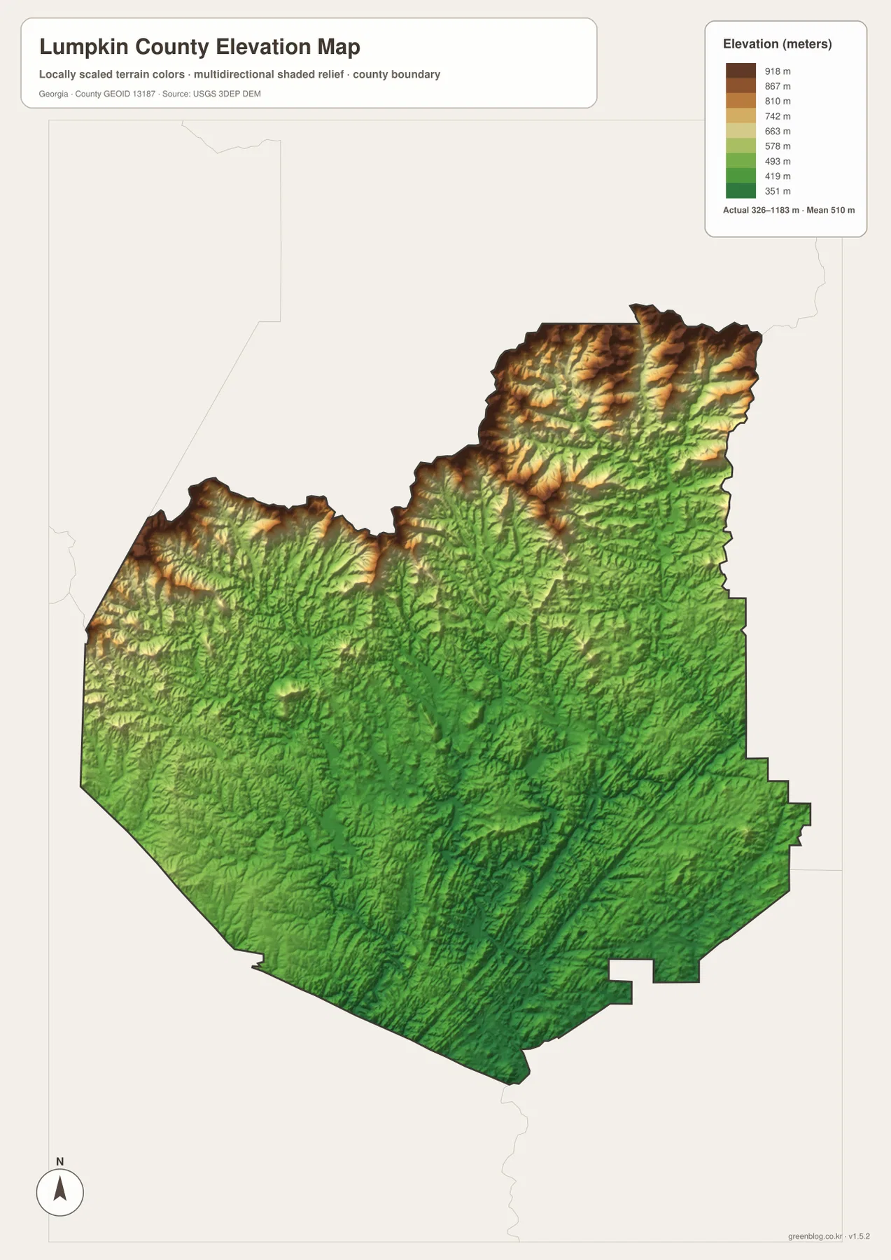
The elevation map makes Lumpkin County’s mountain character unmistakable. The legend reports an actual elevation range of roughly 326 to 1,183 meters, with a mean near 510 meters. Brown and tan colors concentrate across the northern and northwestern ridges, while greener tones become more common through the central and southern parts of the county. The contrast is strong enough that the broad terrain pattern can be understood without locating individual peaks.
The northern section contains tightly packed ridges and valleys, and the western side also shows substantial relief. Moving toward Dahlonega and then farther south, the terrain remains hilly but generally drops into lower elevations and broader valley corridors. This helps explain why the road map and city map look the way they do. The county’s main developed center is not located on the highest ridges, and the major road approaches tend to use lower passages rather than crossing every crest directly.
The shaded surface is intended for county-scale comparison, not site surveying. A color boundary should not be interpreted as an exact contour line, and the displayed elevation surface is not a substitute for engineering-grade measurements, construction surveys, or legal elevation certificates. Its strength is visual: it shows where the county is highest, where lower valleys extend, and how quickly the land changes across a relatively short distance.
When the elevation and water maps are viewed together, the Chestatee River, Yahoola Creek, Cane Creek, and the Etowah-side tributaries occupy lower paths between ridges. In the high north and northwest, smaller streams branch outward from the mountain slopes before joining larger channels. This combination of relief and water explains much more about Lumpkin County than a boundary outline alone, especially for readers trying to understand the setting around Dahlonega and the north Georgia mountains.
How Roads, Valleys, and County Edges Fit Together
Lumpkin County’s major roads provide a useful bridge between the human and physical geography shown in the maps. U.S. 19 and Georgia routes 9 and 60 establish a north-south reference through the Dahlonega area. Route 52 points east, while Route 115 and Georgia 400 help define the southern approach. On the map, these corridors rarely ignore the terrain completely. They bend through lower ground and around ridges, which is typical of a mountainous county where direct straight-line travel is often less practical than following valleys and passes.
This matters when comparing places on the page. A point that looks close in a straight line may require a longer road trip because of winding terrain, creek crossings, and the available mountain routes. The supplied city map does not calculate road travel between multiple cities, and it should not be used as a routing tool. It is better used to understand where Dahlonega sits within the county, while a current navigation service should be used for driving distance and travel time.
The road map also gives context to the county’s neighboring areas. Union and Fannin counties lie toward the higher mountain side of the region, White and Hall are to the east and southeast, and Dawson and Gilmer connect the western and southwestern sides. The exact county line matters for jurisdiction, but this page is not a legal boundary survey. For official boundary work, the U.S. Census Bureau TIGER/Line data or county GIS resources are more appropriate than the visual line in a web preview.
Gold-Rush History Makes More Sense in Its Mountain Setting
Lumpkin County’s history is inseparable from the Georgia gold rush. The county government states that large gold discoveries became widely known in the area in 1828, drawing people and supplies into the region. Lumpkin County was created in 1832, and Dahlonega replaced earlier mining centers as the leading town. In 1838, the federal government opened a branch mint in Dahlonega, where gold coins were produced until the Civil War period. The original mint structure later burned, but the site became associated with the institution that is now the University of North Georgia.
The maps on this page are not mining-history maps, and they do not mark old claims, mine shafts, or historic property boundaries. They do, however, provide the geographic setting behind that history. The county’s steep ridges, narrow valleys, and abundant streams are visible across the water and elevation views, while the city map shows Dahlonega as the clear modern center. Those physical features help a reader place historical accounts in a real landscape instead of treating the gold rush as an isolated event.
The same mountain setting continues to influence the county’s identity. The New Georgia Encyclopedia describes outdoor recreation associated with the region, including activity on the Chestatee River and in nearby forested mountain country, and it notes tourism and wine production as parts of the local economy. The county map therefore works well as a companion to history, tourism, or classroom material when the goal is to explain where Dahlonega is and what kind of terrain surrounds it.
Choosing the Best Map for the Question You Have
For basic orientation, start with the county map. It combines the Lumpkin County boundary, Dahlonega, major roads, selected historical place labels, and a light stream network in one view. If the question is specifically about settlement, the city map removes much of that detail and makes the county’s one-city pattern immediately clear. The water map is better for tracing named rivers and creeks, while the elevation map is the strongest choice for comparing mountain ridges with the lower central and southern valleys.
The maps can also be paired for more useful explanations. A classroom project can place the county map next to the elevation map to show why roads curve through the mountains. A local-history presentation can use the city map to establish Dahlonega as the county center and the water map to show the river systems around the historic gold region. A travel-oriented reference can use the general map to identify major approaches, then use the terrain view to explain why distances and road shapes differ from flatter parts of Georgia.
Each map has limits. The water map is not a flood-risk or boating chart, the elevation surface is not a survey, and the county boundary image is not a parcel map. For those specialized uses, consult the current authoritative source for the exact task. For general geographic reference, however, the four maps provide a concise way to compare roads, settlement, waterways, and terrain without crowding everything into one image.
| State | Georgia |
|---|---|
| County | Lumpkin County |
| County seat | Dahlonega |
| Established | 1832 |
| Major water systems | Chestatee River and Etowah River tributaries |
| Elevation shown | About 326–1,183 m; mean about 510 m |
| Download | ZIP with four high-resolution A3 JPG files |
Frequently Asked Questions
Why does the city map show only Dahlonega as a major city?
The supplied city map ranks major cities rather than listing every community. For Lumpkin County, Dahlonega is the single ranked major city shown and is also the county seat. Smaller unincorporated communities and individual addresses require a more detailed local road or address map, so their absence from this city view should not be interpreted as evidence that they do not exist.
Can the Chestatee and Etowah river systems both be seen on the water map?
Yes. The Chestatee River and several named tributaries are prominent in the northeastern part of the county, while the Etowah River is labeled toward the southwestern and southern side. Yahoola Creek, Cane Creek, Frogtown Creek, Dicks Creek, Mill Creek, Ward Creek, Jones Creek, Montgomery Creek, and Hurricane Creek provide additional reference points between those larger systems.
Is the elevation map accurate enough for surveying or construction work?
No. The map is intended for county-scale terrain reference. It reports a broad elevation range of about 326 to 1,183 meters and a mean near 510 meters, but its colors and shaded relief are generalized for visual comparison. Site design, construction, legal elevation work, or property-level slope analysis should use survey-grade measurements and the appropriate official datasets.
Map File Information
The download ZIP contains four original high-resolution A3 JPG files for Lumpkin County: the county map, city map, water map, and elevation map. Use the archive when you need larger files than the WEBP previews shown on this page.
- Included Versions: County, city, water, and elevation
- Included Files: Four high-resolution A3 JPGs
Related Maps
Sources and Data References
County history and local context were checked against Lumpkin County government and the New Georgia Encyclopedia. The reference list also includes federal sources used for county boundaries, hydrography, elevation, and general county statistics.
- Lumpkin County government history page
- New Georgia Encyclopedia: Lumpkin County
- U.S. Census Bureau QuickFacts for Lumpkin County
- U.S. Census Bureau TIGER/Line Shapefiles
- USGS National Hydrography
- USGS 3D Elevation Program
Green Map creates custom-edited map images using open geographic data sources such as geoBoundaries, Natural Earth, OpenStreetMap, and government open data. These maps are edited visual materials, not raw data files, and are provided for education, documents, presentations, and graphic reference.