Lowndes County lies in south Georgia, with Valdosta near the center of the county’s road and settlement pattern and the Florida state line along the southern edge. The maps on this page show that setting from four useful angles: county boundaries and roads, the relative locations of the main cities, waterways such as the Withlacoochee River and Grand Bay, and changes in elevation across the county. You can download all four maps together as high-resolution A3 JPG files in one ZIP, while lighter WEBP previews are provided in the article for quick viewing.
Valdosta and Interstate 75 make the county easy to orient at first, but they are only part of the geographic picture. The city map shows how Hahira, Remerton, Dasher, and Lake Park are arranged around Valdosta; the water map reveals a much denser network of streams and ponds than the road map suggests; and the elevation view separates the lower southwest and stream corridors from higher terrain across parts of the north and interior. Using the maps together gives a practical county-scale view without requiring specialized GIS software.
Table of Contents
Valdosta and I-75 provide the clearest county orientation
The general county map makes Valdosta the easiest place to start. Interstate 75 runs north-south through the central part of Lowndes County, approaching Hahira from the north, passing the Valdosta area, and continuing toward Lake Park and Florida. U.S. 41 follows the same broad north-south corridor, while U.S. 84 crosses the Valdosta area from west to east. U.S. 221 appears on the western side, and several state-route shields fill in connections toward the county edges. Together, these roads show why Valdosta stands out as the main transportation reference point.
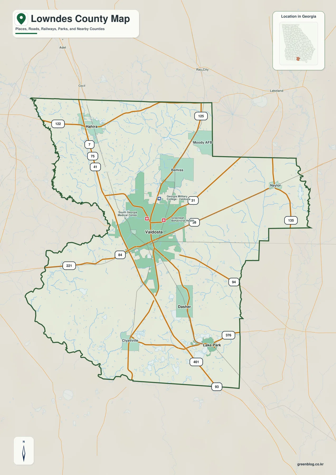
The same map adds smaller place labels that help readers move beyond the five principal cities. Bemiss is marked north of Valdosta, Moody AFB appears to the northeast, Naylor is shown toward the eastern side, and Clyattville appears in the south. Dasher and Lake Park provide additional reference points on the way toward the county’s southern edge. This makes the county map useful when the question involves both a named community and the roads that connect it to Valdosta or the surrounding boundary.
The Georgia-Florida line is an important part of the map because it gives the southern half of the county a clear directional context. Moving from Valdosta toward Lake Park also means moving closer to Florida, while Hahira gives the reader a northern reference point. The map is meant for county-scale orientation rather than street-by-street navigation or property research. It does not attempt to show every local road, parcel boundary, building, or real-time travel condition, so those tasks require a more detailed official source.
Five city markers show a north-south spread around Valdosta
The city map removes much of the road detail and concentrates on Valdosta, Hahira, Remerton, Lake Park, and Dasher. Valdosta sits near the center and is ranked first in the map’s city index. Remerton is immediately adjacent to the Valdosta area, while Hahira is clearly separated to the north. Dasher and Lake Park sit south of Valdosta, with Lake Park farther toward the southeastern part of the county. The simplified layout makes these relationships easier to compare than on a road-heavy map.
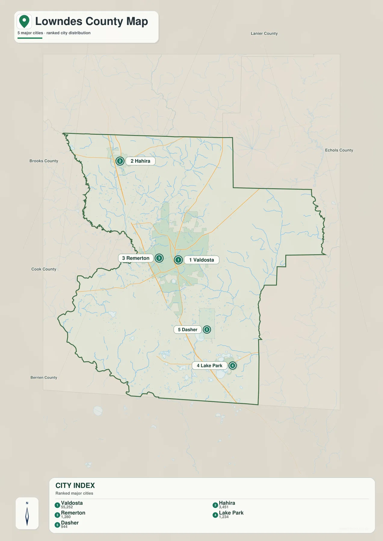
Looking at the city and county maps side by side explains more than either map alone. The city map makes the close Valdosta-Remerton relationship immediately obvious, whereas the county map shows how the wider transportation corridor continues north toward Hahira and south toward Lake Park. Dasher falls between the central and southern parts of that pattern. This is useful for a classroom handout or regional overview because the city map keeps the labels simple, while the general map can be consulted when road numbers and smaller named places matter.
The city index printed on the supplied map also includes population values for the five ranked places. Those numbers are best treated as part of the map’s source data rather than as a claim that the page is presenting the latest population estimate for a specific year. Readers who need current demographic figures can use the Census link in the reference section. For map reading, the more important point is the contrast between the large central Valdosta marker and the smaller communities distributed north and south of it.
Withlacoochee River and Grand Bay reveal a busier water landscape
The water map changes the emphasis from transportation to natural features. The Withlacoochee River is one of the most prominent labels in the northern half of the county, with Franks Creek farther west. Grand Bay appears in the eastern interior, and Grand Bay Creek follows the eastern side of the county. Mud Creek crosses a broad area farther south. Once the road shields are removed, the number of smaller blue stream lines becomes much more noticeable, showing that Lowndes County is crossed by many local drainage features in addition to its larger named waterways.
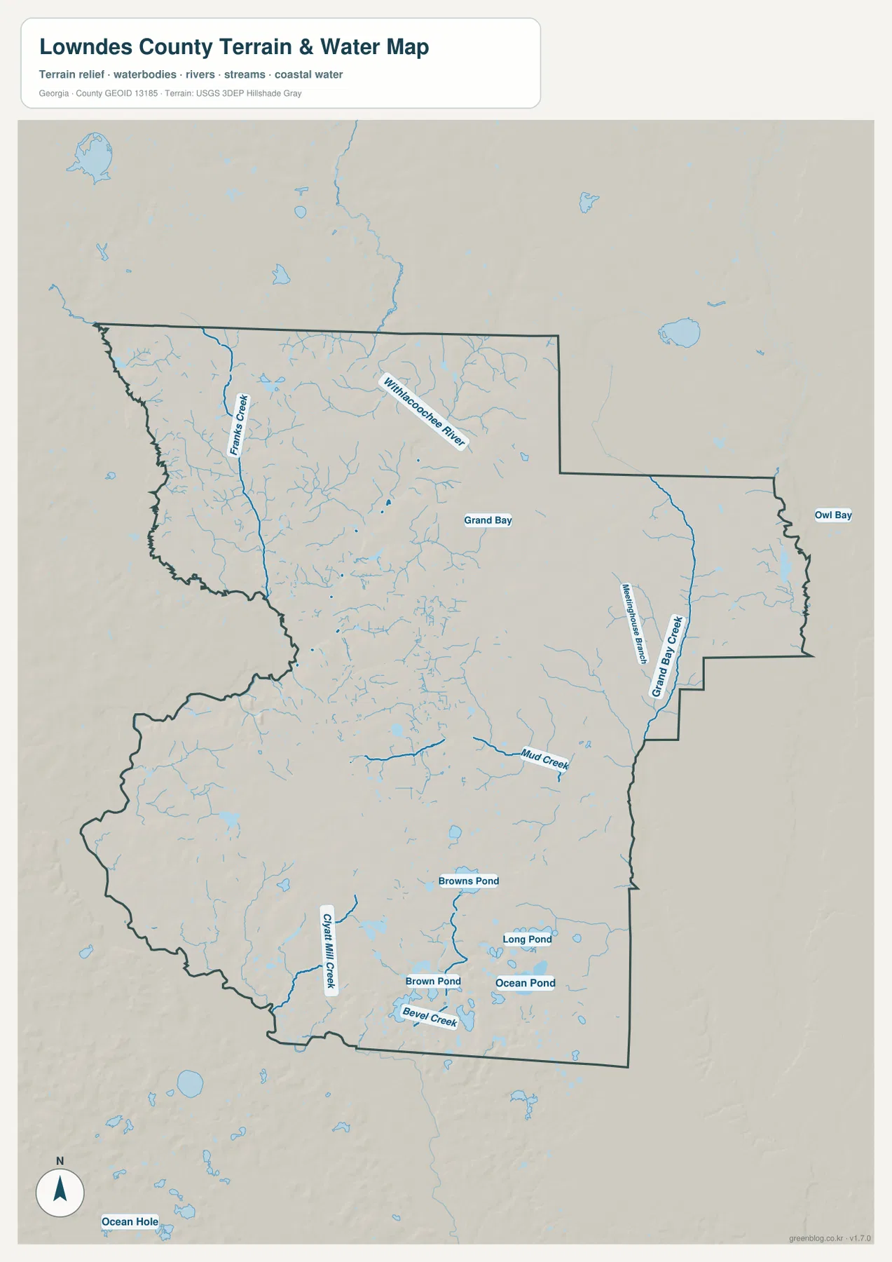
The southern part of the map contains several additional named features. Claybank Creek and Bevel Creek are labeled, and Browns Pond, Brown Pond, Long Pond, and Ocean Pond appear in the same broad part of the county. These names are useful anchors when a reader is trying to locate natural features rather than communities. The combination of creeks and small water bodies also makes the southern landscape look very different from the simple impression created by a map that shows only the county outline and major highways.
Grand Bay is especially useful as an eastern geographic reference because it lies away from the Valdosta-centered road network. Its position, together with Grand Bay Creek and nearby tributaries, gives the eastern side of the county a recognizable natural landmark. This is not a flood-risk map, a legal water-boundary map, or a navigation chart. Its purpose is to show where the larger named rivers, creeks, ponds, and wet areas sit inside the county so they can be compared with the roads, cities, and terrain shown on the other maps.
Lower southwestern ground contrasts with higher northern and central terrain
The elevation map shows a pattern that is almost invisible on the county and city maps. Its legend reports an actual elevation range of roughly 19 to 112 meters and a mean near 53 meters. Green areas represent lower ground, while tan and brown areas represent relatively higher terrain within the county. A broad low area is visible across the southwest and parts of the southern edge, whereas portions of the north and west-central interior have higher, more broken relief.
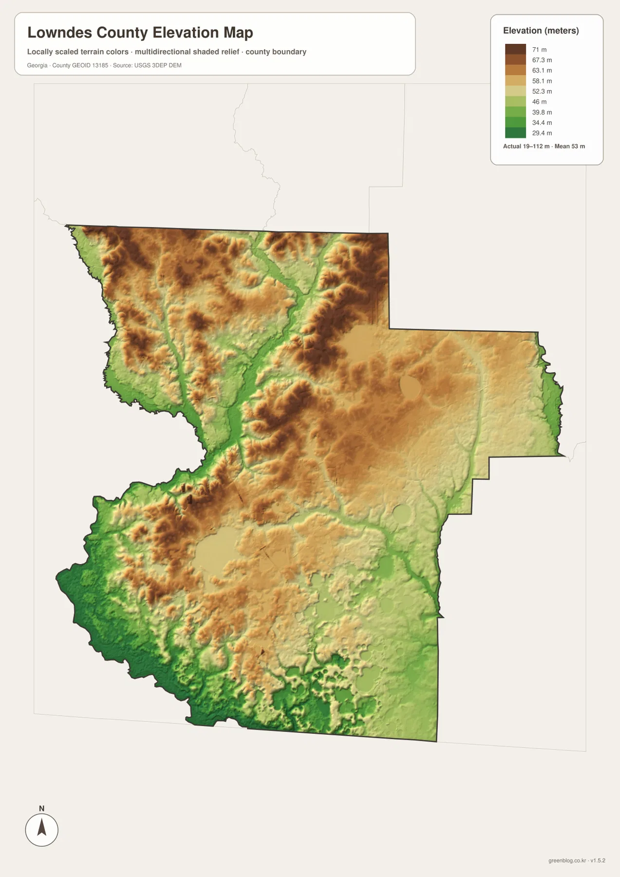
In the northern half, green valley-like bands extend into higher-colored terrain, giving the surface a more varied appearance than a plain administrative map suggests. Lower corridors also appear through the center and east, including terrain associated with the Grand Bay area. Farther south, the county is not mountainous, but the shaded surface still shows many small rises, depressions, and low drainage routes. These local differences matter when the goal is to understand the landscape rather than simply identify a road or city name.
The color scale is designed to compare elevation inside Lowndes County, not to provide survey-grade height for a property, bridge, or road point. Used with the water map, however, it helps explain why many stream corridors follow lower ground. Used with the county map, it gives a broad sense of the terrain crossed by the major roads around Valdosta. For regional geography, this combination is often more informative than quoting a single elevation because it shows where the higher and lower parts of the county actually occur.
Pick the map based on the feature you need to show
Each version is most useful when it answers a specific question. Start with the general county map when you need Valdosta, the full boundary, I-75, U.S. 41, U.S. 84, and smaller named places in one view. Switch to the city map when the relative positions of Valdosta, Hahira, Remerton, Dasher, and Lake Park matter more than road numbers. Use the water map for the Withlacoochee River, Grand Bay, Mud Creek, and the southern ponds, and use the elevation map when the lower southwest and higher northern or central terrain are the main subject.
- County and road reference: best for Valdosta, the county boundary, I-75, U.S. 41, U.S. 84, and smaller place labels.
- Major-city comparison: best for comparing Valdosta, Hahira, Remerton, Lake Park, and Dasher without extra road detail.
- Rivers, creeks, and ponds: best for the Withlacoochee River, Grand Bay, Mud Creek, and the cluster of named water features in the south.
- Terrain and elevation: best for comparing lower southwestern ground with higher sections of northern and central Lowndes County.
The article uses smaller WEBP previews so the page loads more efficiently, but the downloadable files are 2572 by 3638 pixel JPG images in an A3-oriented high-resolution layout. For printing, zooming, or placing a map into a document, use the JPG files from the ZIP rather than saving the preview image from the page. The maps remain county-scale references, so they should be paired with official sources when a task requires parcel lines, legal boundaries, current traffic, engineering measurements, or other site-specific detail.
Frequently Asked Questions
Which map makes the Valdosta-to-Lake Park relationship easiest to see?
The city map is the cleanest choice because Valdosta is centered, Lake Park is farther south, and Dasher appears between the two. If you also need the route context, open the general county map and compare those city positions with I-75 and the surrounding roads.
Can Grand Bay and the Withlacoochee River be found on the same map?
Yes. Both are labeled on the water map. The Withlacoochee River is prominent in the northern half, while Grand Bay and Grand Bay Creek are on the eastern side. The same map also includes Mud Creek and several named creeks and ponds in the southern part of the county.
Should I use the WEBP preview or the JPG files from the ZIP?
Use the WEBP preview when you only need to view the map quickly in the article. Use the 2572×3638 JPG files from the ZIP when you plan to print, zoom in closely, or place a map in a report, slide, or worksheet. The previews are lighter for the web; the JPG files provide the larger downloadable version.
Sources and reference data
The following sources provide county background and authoritative geographic data that can be checked alongside the maps on this page. For legal boundaries, surveying, flood decisions, engineering work, or other specialized uses, consult the appropriate official dataset directly rather than relying on this county-scale reference alone.
- U.S. Census Bureau QuickFacts – Lowndes County, Georgia
- New Georgia Encyclopedia – Lowndes County
- U.S. Census Bureau TIGER/Line Shapefiles
- USGS National Hydrography
- USGS 3D Elevation Program
Map File Information
Download one ZIP containing four high-resolution A3 JPG maps for Lowndes County: the county boundary and roads, major cities, waterways, and elevation. The article uses lighter WEBP previews, while the JPG files are intended for printing, close zooming, and insertion into documents.
- File Type: one ZIP containing four high-resolution A3 JPG images
Related Maps
Green Map creates custom-edited map images using open geographic data sources such as geoBoundaries, Natural Earth, OpenStreetMap, and government open data. These maps are edited visual materials, not raw data files, and are provided for education, documents, presentations, and graphic reference.