You can download the Union County map set on this page as a ZIP containing four high-resolution A3 JPG files. The county is shaped by a strong combination of settlement corridors, reservoir arms, rivers, and long Appalachian ridges. Maynardville, Plainview, and Luttrell occupy the more accessible southern and central passages, while Norris Lake reaches deep into the west and center. Powell River crosses the north, Clinch River extends through the middle and east, and parallel ridges give the southern half of the county a distinctly striped terrain pattern.
The general county map is the best starting point for Maynardville and the road network, including routes 61, 170, 33, 144, 370, and 131. The city map reduces the county to three principal settlement labels. The terrain-and-water map shows how Norris Lake and the river system occupy low valleys, while the elevation map gives an actual county range of about 277 to 706 meters and a mean near 375 meters.
Table of Contents
Maynardville anchors a southern corridor shared with Plainview and Luttrell
Maynardville appears slightly south of the county’s middle and serves as the clearest reference point on the general map. Several roads meet or pass close to the town, and the county-seat label makes it the natural place to begin reading the map. Plainview and Luttrell lie farther southeast, where settlement and road labels are noticeably denser than in the broad reservoir and ridge country to the north and west.
Route 61 approaches from the west, while 33 provides another important connection from the southwest. Routes 144 and 370 help define the Plainview area, and 131 reaches the eastern county boundary. These roads do not form a simple rectangular grid. The reason becomes clear on the water and elevation maps: reservoir arms cut through the interior, and long ridges repeatedly narrow the available low ground.
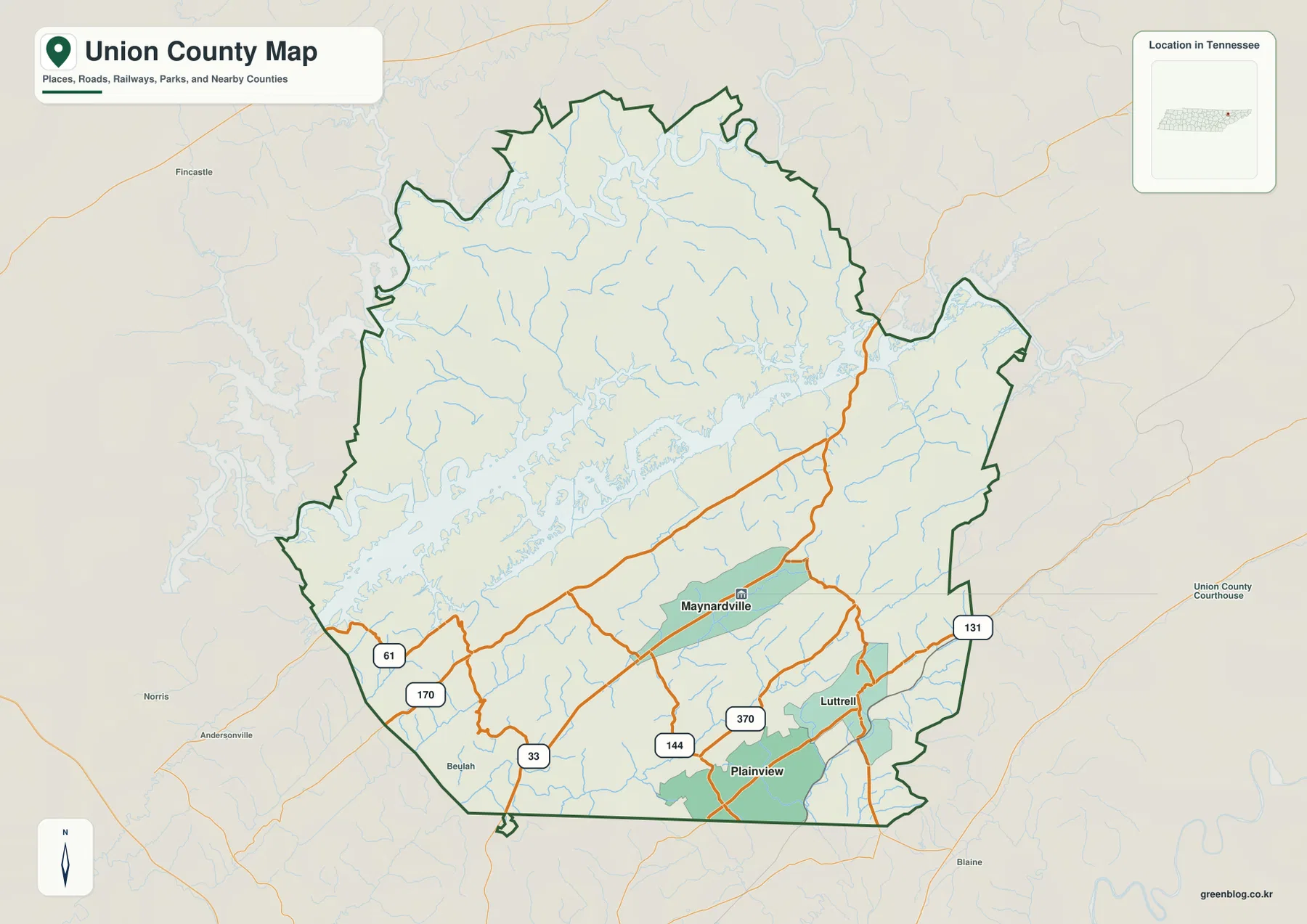
The surrounding county labels provide useful regional orientation. Claiborne County is to the north, Grainger County to the east, Knox County to the south, and Anderson and Campbell counties lie toward the west. Parts of the Union County boundary become irregular where reservoir arms and river valleys cut into the landscape, so the county outline should be checked directly when a nearby place appears close to an edge.
Three settlement labels reveal a compact Maynardville–Plainview–Luttrell pattern
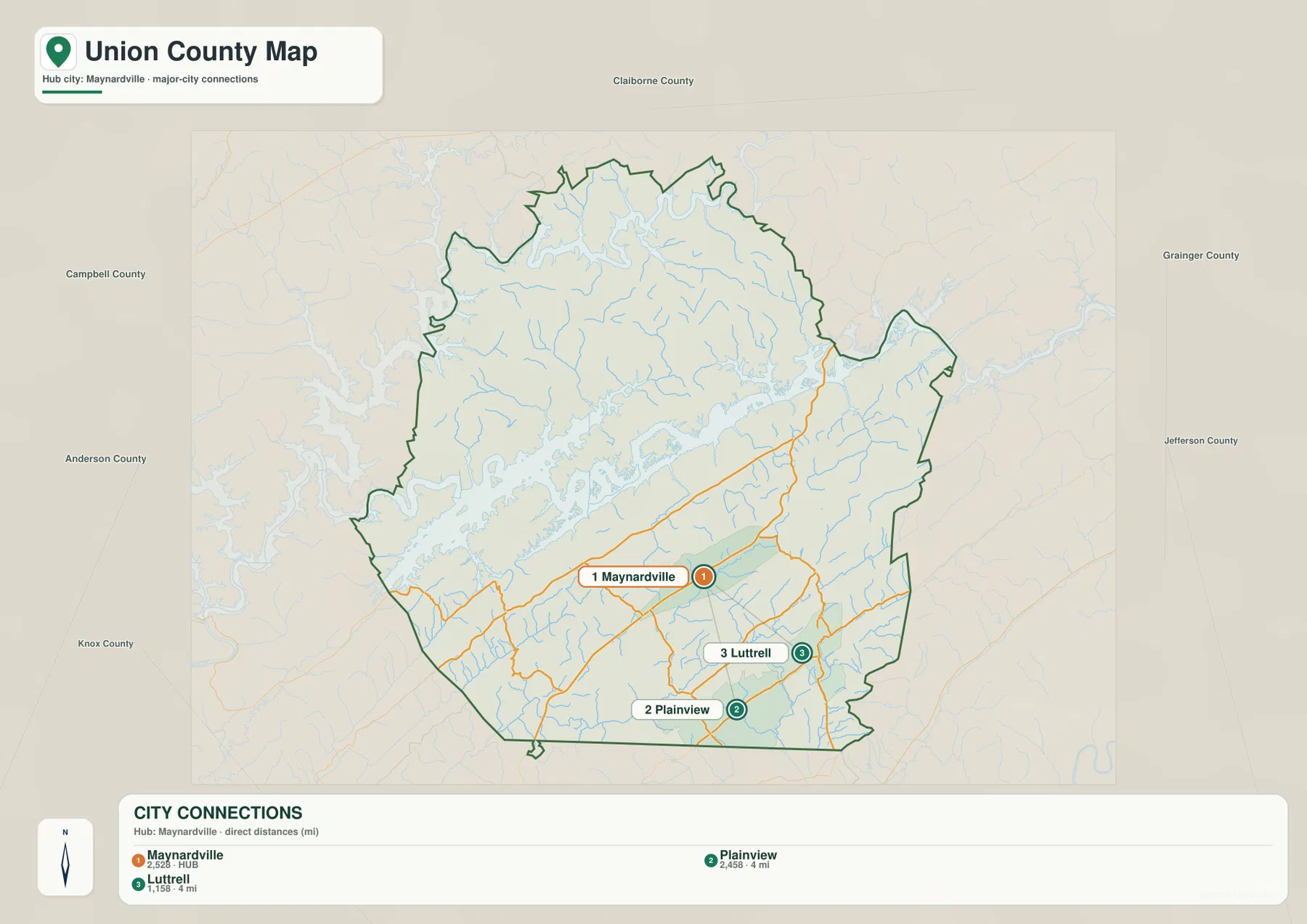
The supplied city map ranks three places. Maynardville is labeled at 2,528, Plainview at 2,458, and Luttrell at 1,158. Using Maynardville as the hub, the graphic shows both Plainview and Luttrell at about 4 miles by direct distance. These are values from the provided city map and are useful for relative comparison; they are not driving distances or a substitute for a current official population table.
Maynardville is the northwestern point of the three, Plainview lies to the south, and Luttrell is farther east. Their close spacing shows where the county’s main named settlement cluster is concentrated. Yet the roads between them are influenced by creeks and ridges, so a 4-mile straight line does not mean every trip follows a similarly short road. The general map should be used alongside the city graphic when actual access matters.
The countywide figures are much larger than the three city labels. The supplied references give a 2020 census population of 19,802 and a July 2025 estimate of 21,450, with about 223.6 square miles of land and 23.6 square miles of water. Large portions of northern and western Union County therefore need to be understood through rural roads, lake shores, ridges, and smaller communities rather than through the three ranked city markers alone.
Norris Lake, Powell River, and Clinch River divide the county into narrow land corridors
Norris Lake is the dominant water feature on the terrain map. From the western side, long reservoir arms penetrate the center through narrow valleys, producing a shoreline with many fingers, coves, and points. The effect is geographically important even where two pieces of land look close on a flat map: a long water arm may force a road to follow the shoreline, reach the head of a cove, or use one of the limited crossings.
Powell River is labeled across the northern part of the county, while Clinch River occupies the central and eastern water system. South of those larger waters, Bullrun Creek and North Fork Bullrun Creek follow long valleys through the ridge country. Raccoon Creek, Flat Creek, and Hogskin Creek provide additional southern references, and Dodson Creek with Beech Branch is visible toward the east. The stream directions closely match the low passages seen in the shaded terrain.
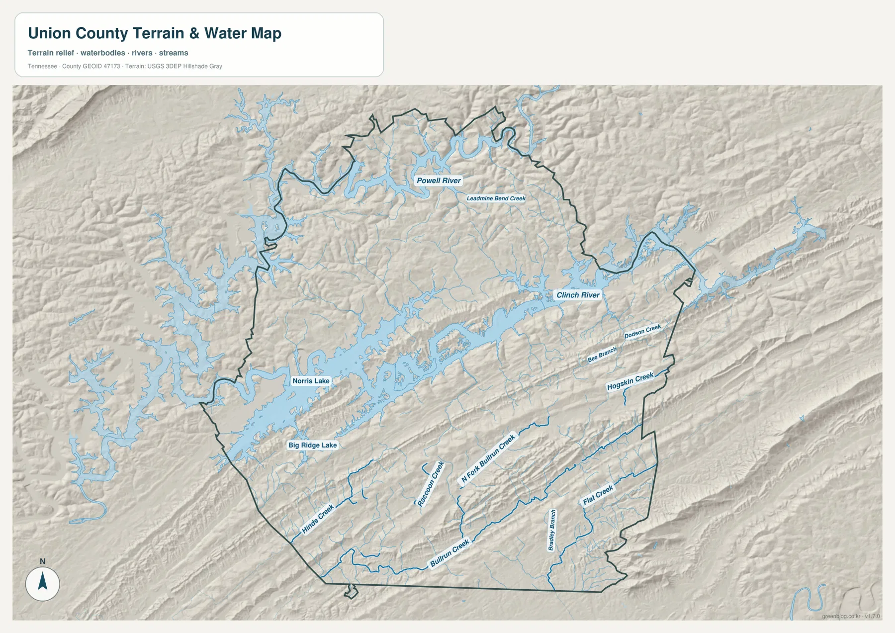
Big Ridge Lake is also labeled near the southwestern Norris Lake area. The supplied county references identify Big Ridge State Park as an important local landscape feature, making this part of the map useful for understanding the relationship between reservoir shoreline and surrounding hills. The map is not a live boating or flood product, however, and it does not show current water level, ramp access, flood extent, or park operating conditions.
Parallel ridges rise from 277-meter valleys to terrain above 700 meters
The elevation map gives Union County an actual mapped range of about 277 to 706 meters and a mean near 375 meters. The southern half is especially distinctive. Long ridges run from southwest to northeast in repeated parallel bands, separated by narrow green valleys. The eastern side contains similarly strong elongated ridges, while the northern section is broken into shorter and more irregular hills.
Lower green terrain is concentrated around Norris Lake, Clinch River, and many tributary valleys. The reservoir arms visibly occupy low gaps between the ridges, which is why the shapes on the water and elevation maps match so closely. Higher brown terrain becomes more continuous toward parts of the southeast and east, where several ridges rise above 500 meters and locally approach the upper end of the county range.
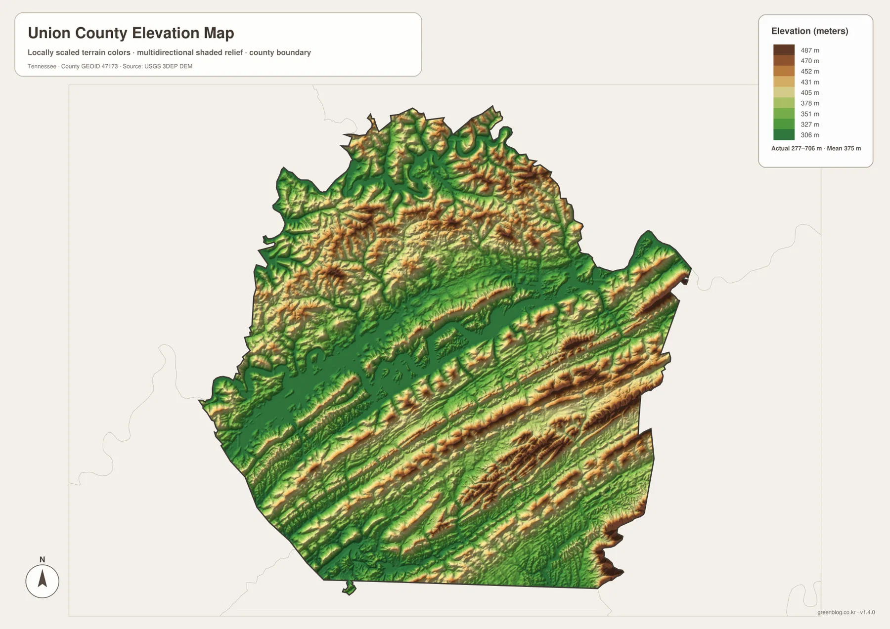
The existing reference material identifies the Ridge-and-Valley Appalachians and Clinch Mountain as important regional terrain names. The repeated ridge pattern on the map is consistent with that broader setting. This colored elevation surface is appropriate for county-scale comparison, but it should not be used to determine a parcel’s exact elevation, road grade, building site, or legal flood elevation.
Road access makes more sense when the water and ridges are read together
The roads radiating from Maynardville appear relatively simple on the general map, but the physical layers explain their curves. Norris Lake blocks direct movement through much of the west and center, while the long ridges of the south and east narrow the usable passages. Roads therefore tend to follow valleys, approach water crossings at practical locations, and bend around higher ground instead of connecting every community by the shortest geometric line.
Plainview and Luttrell sit in the more accessible southern corridor, where several roads can connect through lower terrain. Conditions change toward the north, where reservoir arms, large rivers, and more irregular hills create longer detours. This is particularly important around peninsulas on Norris Lake: two shoreline locations may be visually close while their road connection runs a much greater distance around the water.
Dividing the 2020 population of 19,802 by the listed 223.6 square miles of land gives about 88.6 residents per square mile. That countywide average is only background context. The city and elevation maps show why settlement is not evenly distributed: named population centers are concentrated in the more accessible southern and central passages, while large reservoir and ridge areas contain fewer major city labels.
Choosing a Union County map for roads, lake geography, or relief
Use the general county map when you need Maynardville, the principal roads, nearby settlements, and the boundary in one view. The city map is faster when your question is limited to the relative position of Maynardville, Plainview, and Luttrell. For Norris Lake, Powell River, Clinch River, and named creeks, the terrain-and-water map provides the clearest detail. The elevation map is the best companion when you want to understand why those waterways and roads occupy certain valleys.
For printed study or annotation, one copy can focus on Maynardville, Plainview, Luttrell, and major routes such as 61, 33, and 131. A second copy can mark Norris Lake, Clinch River, Powell River, Bullrun Creek, and the long southern ridges. Keeping transportation and physical geography partly separated makes the county easier to read without covering the map with duplicate labels.
Union County was established in 1850, and Maynardville is the county seat in the supplied reference material. Big Ridge State Park, Norris Lake, and the river-and-ridge landscape create a second layer of geography that is just as important as the administrative center. The county is best understood by connecting those two views: a Maynardville-centered settlement corridor set within a much larger landscape of reservoir arms and Appalachian ridges.
Frequently Asked Questions
How close are Maynardville, Plainview, and Luttrell on the supplied city map?
The map uses Maynardville as the hub and shows both Plainview and Luttrell at about 4 miles by direct distance. They form a compact southern-central settlement cluster, but actual driving distance can be longer because roads must work around ridges, creeks, and other terrain.
Why does Norris Lake matter so much to the shape of Union County?
Norris Lake sends long reservoir arms into western and central valleys, dividing the land into peninsulas and narrow corridors. Its influence on road access is therefore much greater than a simple countywide water percentage suggests. Current lake levels, boating access, and flood conditions should be checked with current official sources.
What creates the long striped pattern on the elevation map?
The stripes are elongated ridges and intervening valleys that run mainly southwest to northeast, especially across southern Union County. The supplied elevation map ranges from about 277 to 706 meters, with lower terrain around Norris Lake and the river valleys and higher ridges toward the south and east.
Map File Information
The ZIP contains the high-resolution JPG originals for the Union County map, city map, water map, and elevation map shown on this page. The four A3-format images are better suited to printing, enlarged viewing, and annotation than the WebP previews in the article.
- Included Files: County map, city map, water map, and elevation map
- File Type: ZIP containing 4 JPG images
Related Maps
- Alamo to Gadsden: A Crockett County Tennessee Map
- Altamont, Monteagle, and Plateau Valleys — Grundy County Tennessee Map
- Around Chattanooga: Hamilton County Tennessee Map
Sources and References
- Tennessee State Library and Archives Union County fact sheet
- Tennessee Department of Transportation Union County map
- U.S. Census Bureau Union County QuickFacts
- USGS National Hydrography
- USGS 3D Elevation Program
Green Map creates custom-edited map images using open geographic data sources such as geoBoundaries, Natural Earth, OpenStreetMap, and government open data. These maps are edited visual materials, not raw data files, and are provided for education, documents, presentations, and graphic reference.