You can download the Unicoi County map set on this page as a ZIP containing four high-resolution A3 JPG files. The defining feature of the county is not a broad plain but a chain of narrow valleys surrounded by steep mountain ridges. Erwin and Unicoi occupy the lower central corridor, and I-26 follows much of the same passage. The water and elevation maps explain why those settlements and roads are concentrated in a relatively small part of the county.
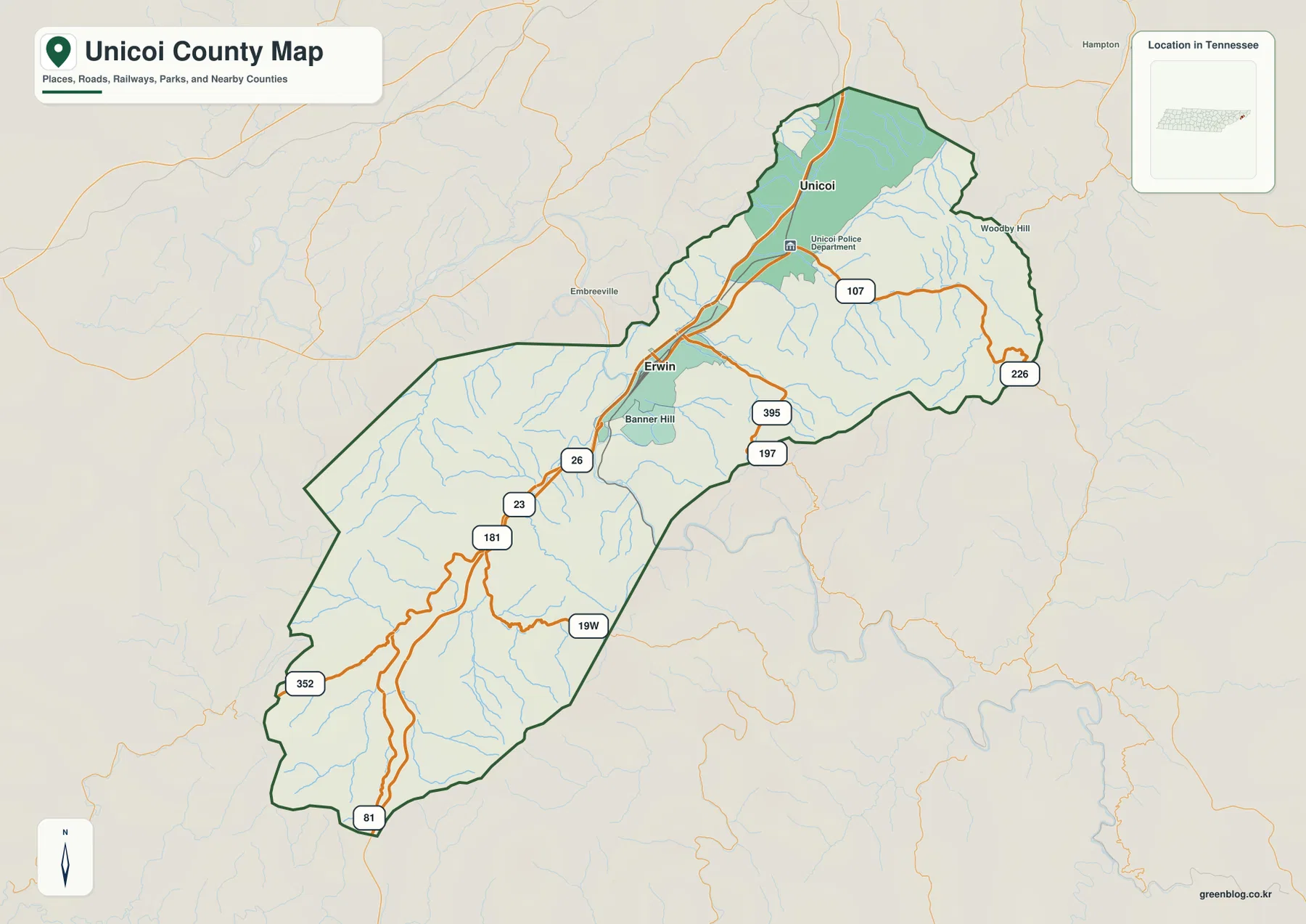
The general map labels Erwin, Unicoi, and Banner Hill, along with I-26 and routes such as 19W, 107, 226, 197, 395, 23, 181, 352, and 81. The water map adds South Indian Creek, North Indian Creek, Rock Creek, Buffalo Creek, Spivey Creek, Higgins Creek, and a number of smaller branches. Elevation ranges from about 478 to 1,679 meters, with a mean near 838 meters, so the difference between the occupied valleys and the surrounding mountain terrain is unusually large.
Table of Contents
Erwin and Unicoi share a narrow north–south valley corridor
Erwin sits near the central part of the county and provides the main administrative reference. Unicoi lies farther north in the elongated upper section. On the map, the two places do not look like isolated towns separated by open countryside. Instead, they occupy the same broad valley system, with high ground pressing close to the developed corridor on both sides.
I-26 is the clearest transportation line through this landscape. It runs along the lower corridor from the southwest through Erwin and toward Unicoi rather than cutting directly across the higher ridges. Around Erwin, 19W and several state routes branch toward adjoining valleys. North and east of Unicoi, routes 107 and 226 extend into more rugged terrain, while 23, 181, 352, and 81 provide references in the long southwestern section.
Unicoi County is in East Tennessee. The supplied reference material identifies Washington and Greene counties on the western and northern side, Carter County to the east, and Mitchell, Yancey, and Madison counties in North Carolina along the wider mountain-border setting. In this terrain, a nearby place on the opposite side of a ridge may require a much longer road connection than the straight-line distance suggests.
A city map dominated by Erwin and Unicoi rather than many separate centers
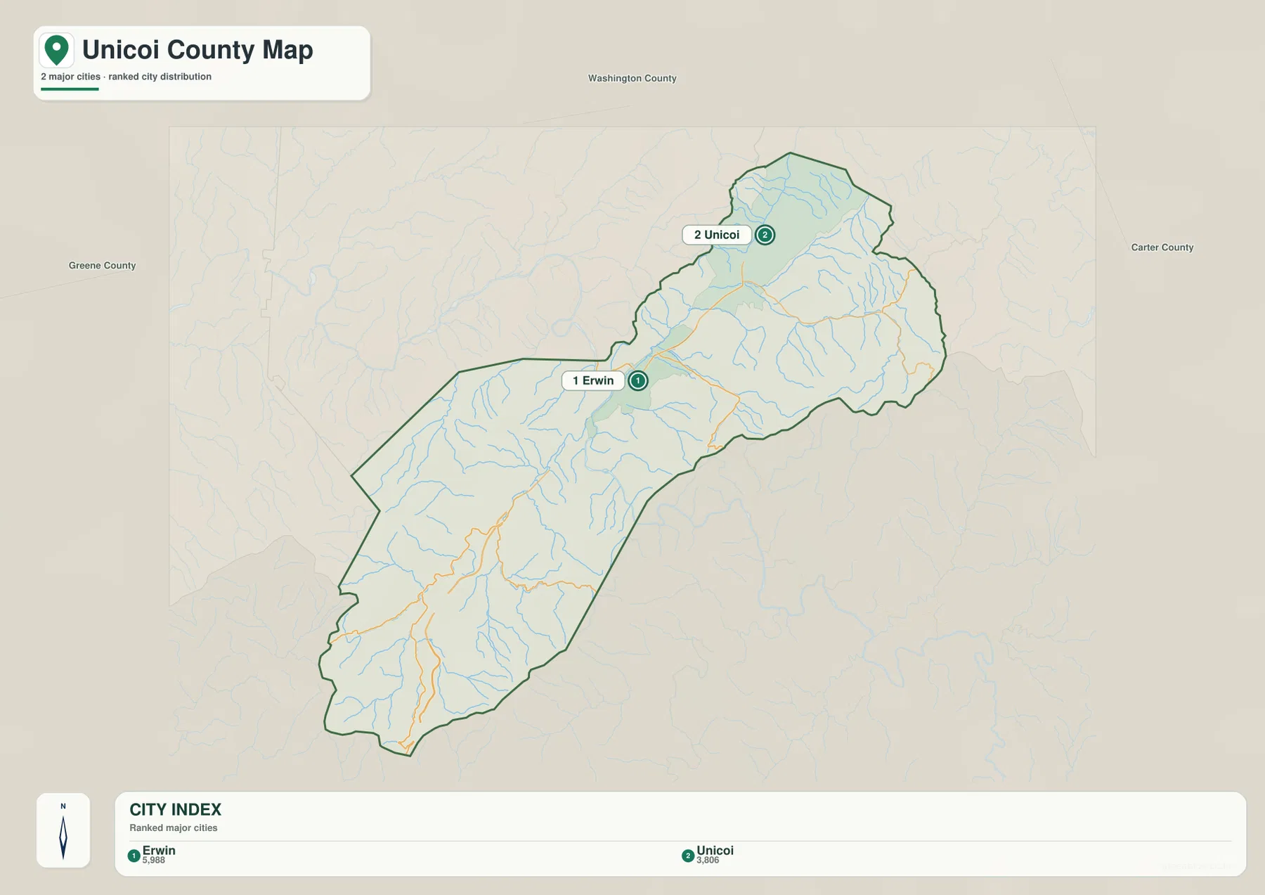
The supplied city map highlights only two ranked places. Erwin is listed first at 5,988 and Unicoi second at 3,806. Those values belong to the city graphic and are useful for comparing the two mapped centers; they should not be treated as the total population of the county or as a current replacement for official countywide counts.
The positions of the two cities reveal more than the ranking itself. Erwin occupies the stronger road junction and is the county seat, while Unicoi extends the settlement pattern northward through the same low corridor. Much of the surrounding county is mountainous, so the map has large areas with few major city labels even though the county boundary covers a much wider landscape.
The existing reference data gives a 2020 census population of 17,928 and a July 2025 estimate of 17,856. The county contains about 186.1 square miles of land and 0.3 square miles of water. Dividing the 2020 count by the land area gives roughly 96.3 residents per square mile, but that countywide average hides the strong concentration of settlement in valleys and the large amount of steep mountain land outside the two main city labels.
Creeks trace the low passages between closely packed ridges
The terrain-and-water map is filled with narrow streams rather than large lakes. Around the northern Unicoi area, Buffalo Creek and Simerly Creek occupy branching valleys. North Indian Creek is prominent on the eastern side, while Dry Creek and Rock Creek descend toward the central corridor near Erwin. South Indian Creek and Spivey Creek are among the clearest waterways in the southern half.
Additional labels include Higgins Creek and Clark Creek in the west, Davy Fork Creek and Rice Creek farther southwest, and Granny Lewis Creek and Long Branch near the middle. The shaded relief makes their setting easy to recognize: the streams follow narrow low ground between ridges instead of crossing the mountains randomly. The same valleys often provide the most practical space for roads and settlement.
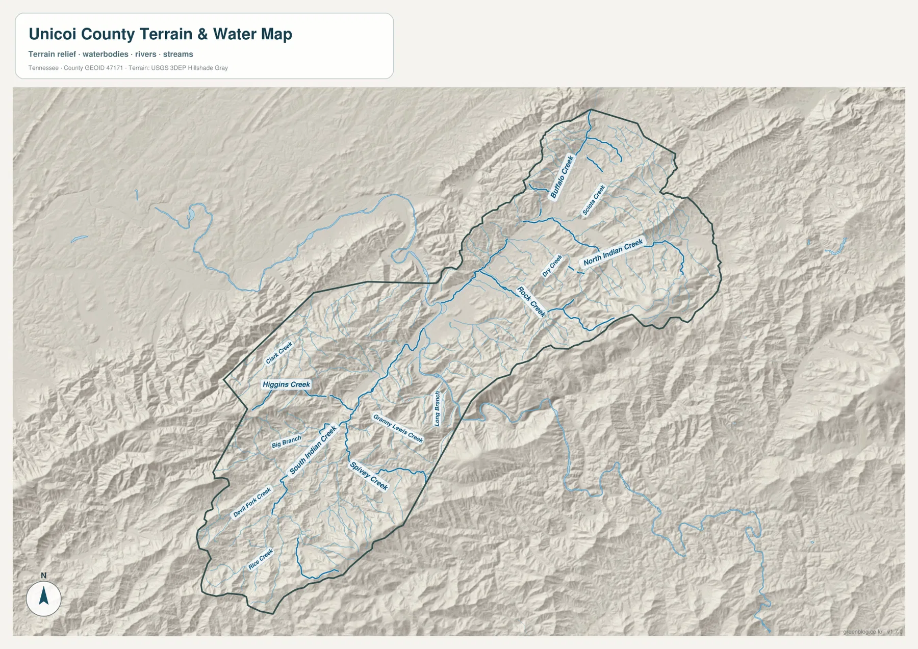
The existing county material also identifies the Nolichucky River as an important geographic feature, although the supplied water preview is most useful for reading the individual creek valleys. This is a static reference map rather than a live hydrology product. It does not provide current stream stage, flood extent, water depth, boating conditions, or legal property boundaries.
A dramatic rise from 478-meter valleys to 1,679-meter mountains
The elevation map gives Unicoi County a mapped range of about 478 to 1,679 meters and a mean near 838 meters. Deep green marks the lower Erwin–Unicoi valley and other stream corridors, while yellow, tan, and brown cover the higher ridges. The county therefore contains roughly 1,200 meters of vertical difference between its lowest and highest mapped ground.
The eastern and southeastern boundary contains some of the most extensive high terrain, with additional high ridges across the southwest. Around Unicoi, the main valley is broader and lower, but steep slopes rise quickly outside it. Even places that look close on a flat map can be separated by a ridge that forces roads to follow a longer valley or gap.
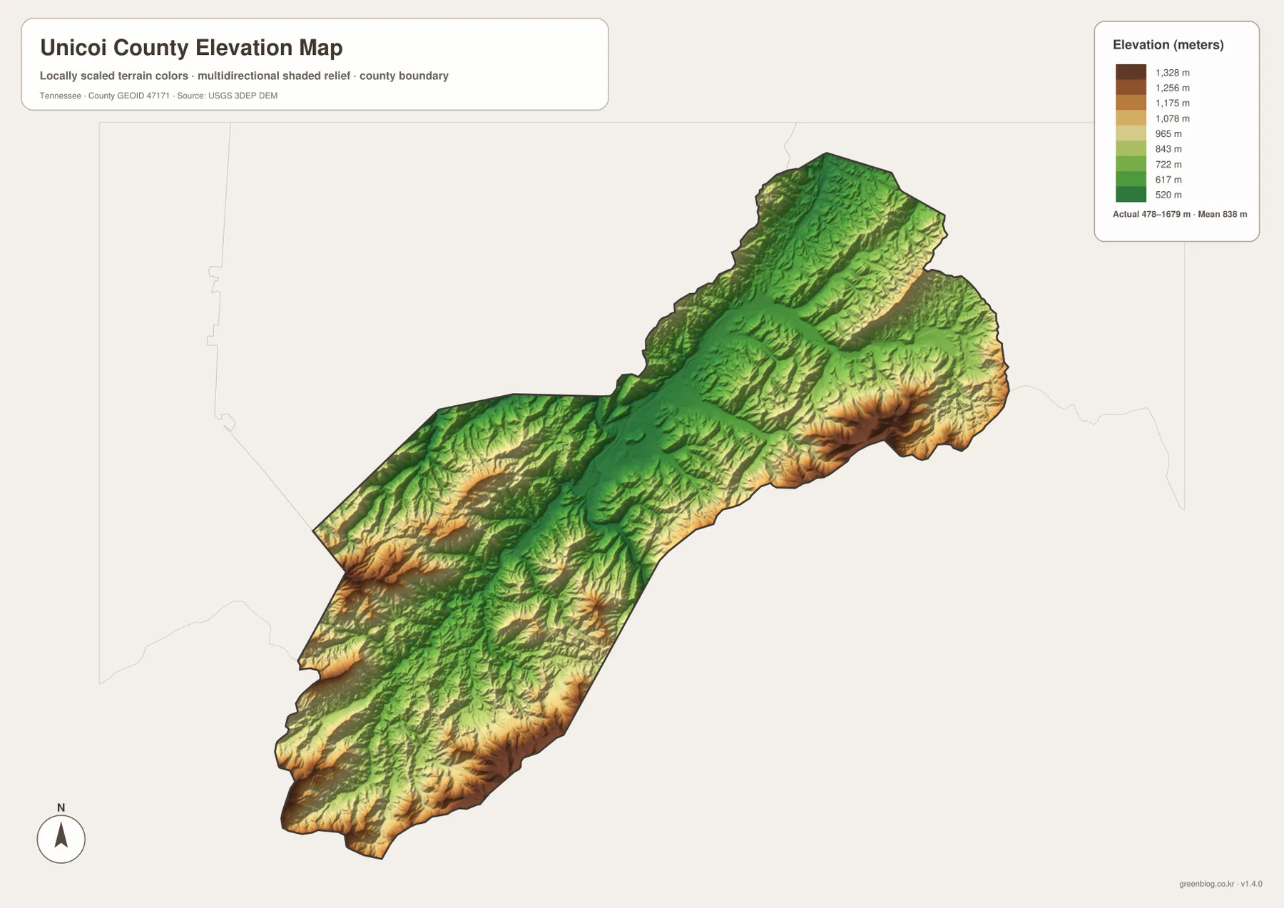
The supplied reference material names the Blue Ridge Mountains, Bald Mountains, Unaka Range, and Big Bald as important regional terrain features. It also identifies portions of the Appalachian Trail and Cherokee National Forest, as well as Rocky Fork State Park. The elevation layer is useful for seeing the broad mountain setting, but it is not intended to replace detailed trail, park-boundary, engineering, or survey maps.
Why I-26 follows the valley instead of crossing the mountains directly
The relationship between the general map and the elevation layer is especially clear along I-26. The highway stays within the lower corridor through Erwin and toward Unicoi because the surrounding ridges rise sharply. The same principle applies to many secondary roads: they use stream valleys and gaps where possible rather than climbing directly over every ridge.
Routes 395 and 197 east of Erwin and 107 and 226 farther northeast show how roads reach toward the mountain edges. In the southwest, 23, 181, 352, and 81 follow the long lower section of the county. Once the elevation colors are considered, the road network looks less like a collection of arbitrary curves and more like a set of routes constrained by valleys and mountain passes.
That terrain also explains why straight-line distance can be misleading. A ridge may stand between two nearby map points, and winter weather, construction, or closures can change practical access. Use the county maps for orientation and comparison, then rely on current transportation or land-management information for actual travel decisions.
Choosing a Unicoi County map for roads, water, or mountain relief
The general county map is the best first choice when you need Erwin, Unicoi, I-26, secondary roads, and the county boundary in one view. The city map removes most of that detail and makes the two main settlement centers easy to compare. The water map is more useful for identifying which creek occupies a particular valley, while the elevation map explains how sharply the terrain rises away from those low corridors.
For a printed study sheet, start by marking Erwin and Unicoi and tracing I-26 between them. On a second copy, add South Indian Creek, North Indian Creek, Rock Creek, Buffalo Creek, Spivey Creek, and the higher eastern and southern ridges. Separating transportation from physical geography keeps the map readable and makes the relationship between the valley floor and surrounding mountains easier to understand.
Unicoi County was established in 1875, and Erwin is the county seat in the supplied reference material. That administrative role aligns with the modern map because Erwin also sits at the strongest road junction in the county. The large mountain areas outside the main valley explain why a small number of city labels can coexist with a county that covers a much larger and more rugged landscape.
Frequently Asked Questions
Why do Erwin and Unicoi appear along the same narrow corridor?
Both places occupy lower ground in the same broad mountain valley, and I-26 follows much of that corridor. Higher ridges rise quickly on either side, concentrating major roads and settlement in the available low terrain. Actual driving distance still depends on road curves, mountain passes, and current conditions.
What is most striking about the Unicoi County elevation map?
The large elevation range stands out immediately. The supplied map spans roughly 478 to 1,679 meters, with lower green valleys around Erwin and Unicoi and much higher terrain along the eastern, southern, and southwestern sides. The map is intended for county-scale comparison rather than parcel surveying or engineering measurement.
Which creeks are easiest to identify on the water map?
South Indian Creek, North Indian Creek, Rock Creek, Buffalo Creek, Spivey Creek, and Higgins Creek are among the clearest labels. Dry Creek, Davy Fork Creek, Rice Creek, Granny Lewis Creek, and several smaller branches also trace narrow valleys across the county. Current flood or stream conditions require live official data rather than this static map.
Map File Information
The ZIP contains the high-resolution JPG originals for the Unicoi County map, city map, water map, and elevation map shown on this page. The four A3-format images are better suited to printing, enlarged viewing, and annotation than the WebP previews in the article.
- Included Files: County map, city map, water map, and elevation map
- File Type: ZIP containing 4 JPG images
Related Maps
- Alamo to Gadsden: A Crockett County Tennessee Map
- Altamont, Monteagle, and Plateau Valleys — Grundy County Tennessee Map
- Around Chattanooga: Hamilton County Tennessee Map
Sources and References
- Tennessee State Library and Archives Unicoi County fact sheet
- Tennessee Department of Transportation Unicoi County map
- U.S. Census Bureau Unicoi County QuickFacts
- USGS National Hydrography
- USGS 3D Elevation Program
Green Map creates custom-edited map images using open geographic data sources such as geoBoundaries, Natural Earth, OpenStreetMap, and government open data. These maps are edited visual materials, not raw data files, and are provided for education, documents, presentations, and graphic reference.