The Saluda County Map on this page shows a county organized around the town of Saluda, a set of smaller communities to the south, and a strong river-and-lake boundary in the northeast. You can preview the road map, city-connections map, and terrain-and-water map in the article, then download the matching high-resolution A3 JPG files in a ZIP archive. The maps are especially useful for comparing Saluda with Ward, Ridge Spring, and Monetta while also seeing how the Saluda River, Little Saluda River, and Lake Murray shape the county’s eastern side.
The general county map is the best place to start for route numbers and community names. The city map simplifies the same area by using Saluda as a hub and listing straight-line distances to three southern places. The water map changes the emphasis again, replacing most road detail with the Saluda and Little Saluda rivers, Big Creek, Lake Murray, and smaller tributaries. Using the three views together makes it easier to move from a town name to a road corridor and then to the surrounding drainage.
Table of Contents
Roads radiate from Saluda toward Ridge Spring, Ward, and the county edges
Saluda is the clearest road-network anchor on the county map. Routes 378 and 39 pass through the central area, while 702 extends toward the northwest. On the northern and northeastern side, 395 and 194 provide additional reference lines. South of Saluda, routes 121, 193, and 23 lead into the part of the county where Ward and Ridge Spring are shown.
The southeastern corner has another group of useful labels. Ridge Spring and Monetta sit close to the lower edge of the county, with Route 392 running along that area. Farther east, the map shows 178, 1, and 391 near the Batesburg-Leesville side. Reading the map from Saluda outward works better than trying to memorize every route at once: central routes establish the hub, southern roads locate the smaller towns, and the eastern routes provide the transition toward neighboring areas.
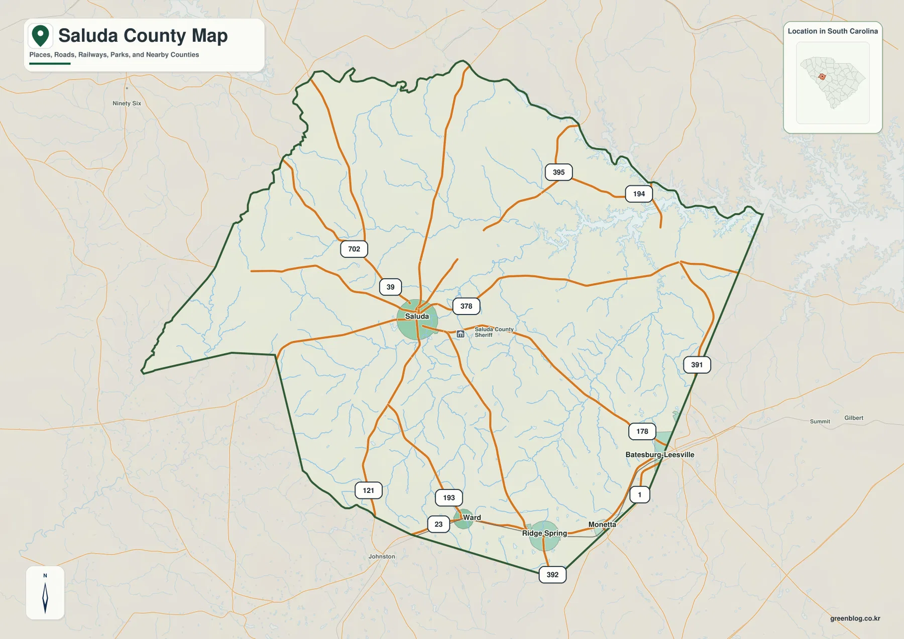
The map also places Ward inside the southern portion of the county and uses Ridge Spring and Monetta as clear references near the lower boundary. Batesburg-Leesville appears farther east as a nearby place outside the main Saluda-centered cluster. These labels are useful for orientation rather than precise municipal-boundary measurement. For a general reader, they make the county’s long central-to-southeastern road pattern much easier to understand.
The city map puts Ward, Ridge Spring, and Monetta 10 to 14 miles from Saluda
The city-connections map uses Saluda as the hub. Its legend shows Ward at about 10 miles, Ridge Spring at about 13 miles, and Monetta at about 14 miles from Saluda. Those figures are straight-line distances, not driving distances. A road trip between the places may be longer because the actual route follows the road network rather than a direct line.
The directions matter as much as the numbers. Ward and Ridge Spring are south of Saluda, while Monetta lies farther to the southeast. None of the three forms a dense continuous urban cluster with Saluda on the map. That spacing explains why the county map shows several separate southbound roads rather than one single corridor connecting all of the places in a row.
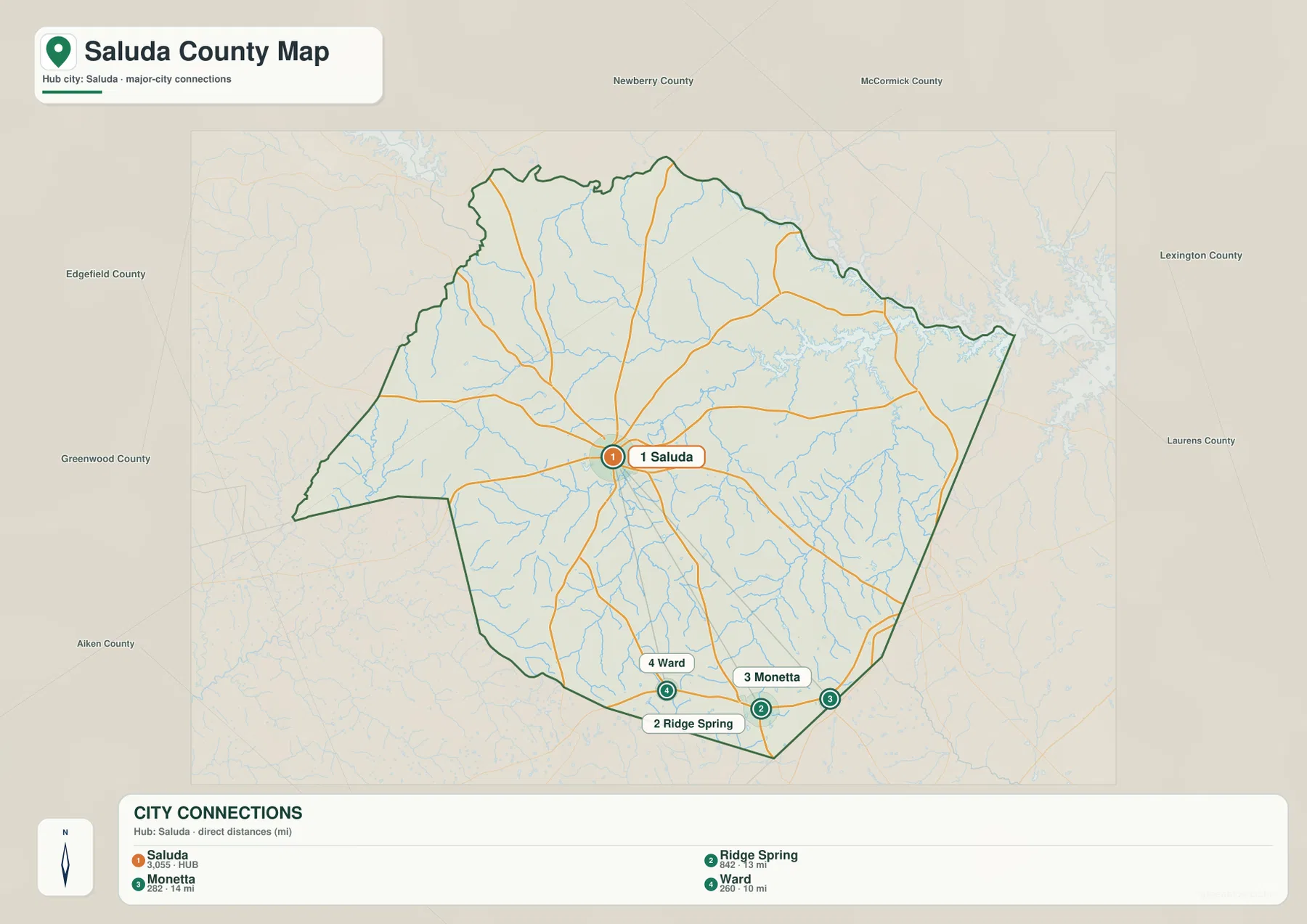
County names are placed around the outside of the city map to provide broader geographic context. They are secondary references rather than substitutes for the actual county boundary. When the question is how to travel between Saluda and one of the southern towns, the most useful workflow is to locate the direction on the city map and then return to the county map for the numbered roads.
Lake Murray, the Saluda River, and the Little Saluda River define the water map
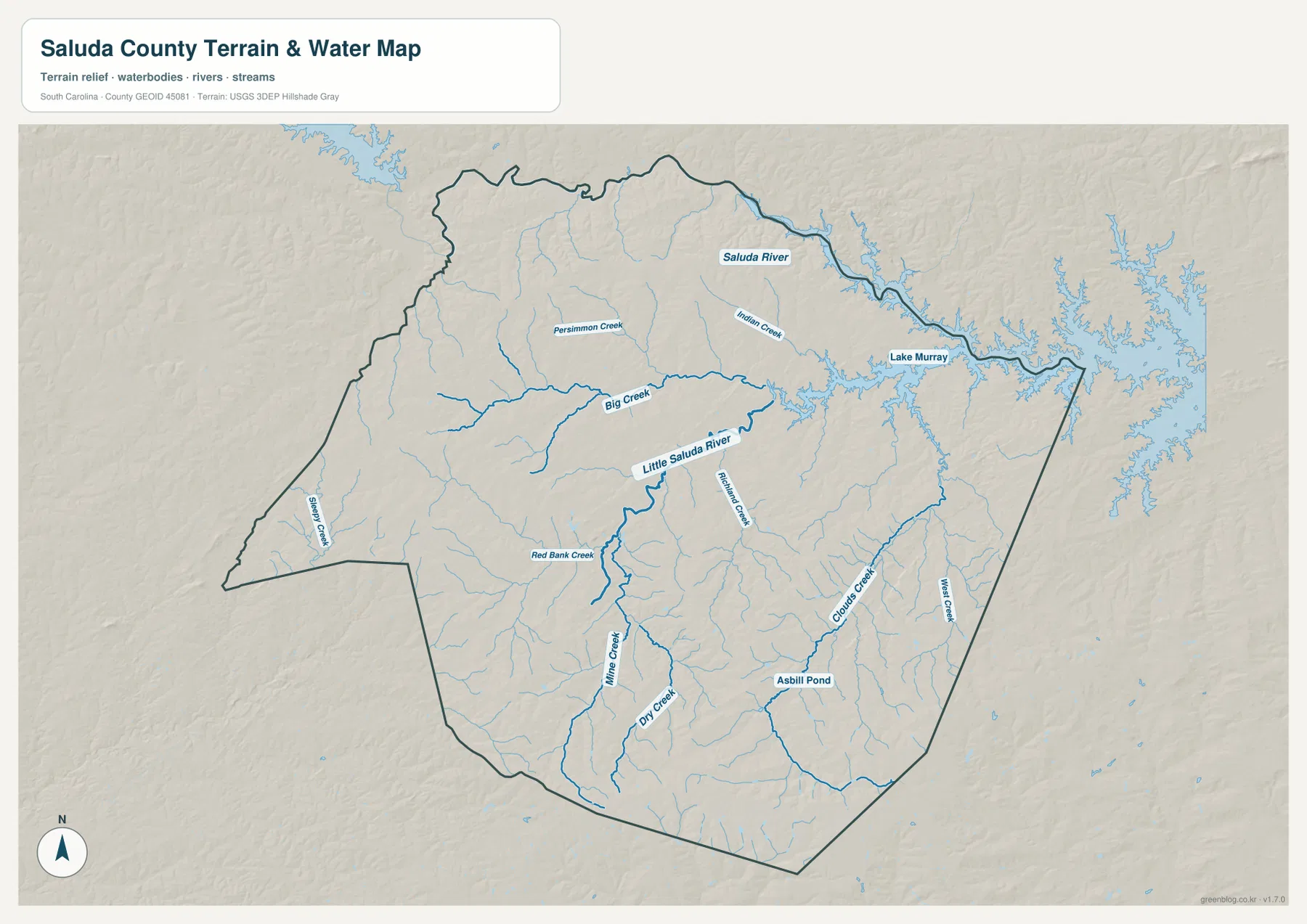
The northeastern side of the terrain-and-water map is dominated by Lake Murray. The Saluda River follows the northern and northeastern side of the county toward the lake, creating a strong water reference along that edge. The Little Saluda River is labeled through the central portion of the county and provides a second major channel inside the boundary. Together, the lake and the two rivers give the water map a much clearer structure than the dense network of smaller tributaries might suggest at first glance.
Several named creeks add detail between the larger channels. Big Creek crosses the central-northwestern area, while Red Bank Creek and Mine Creek appear farther south and southwest. Persimmon Creek and Indian Creek are labeled in the northern half. Clouds Creek and West Creek stand out on the southeastern side. These features are useful for understanding the location of waterways, but the map is not a flood-hazard, navigation, or water-level product.
Smaller creeks and Asbill Pond fill in the county between the major rivers
Big Creek is one of the easiest tributaries to follow because it runs across a broad central section toward the Little Saluda River. Red Bank Creek and Mine Creek provide additional reference lines in the southwestern half, while Dry Creek appears farther south. In the southeast, Clouds Creek and West Creek form another pair of clearly labeled channels. The smaller streams make it clear that Saluda County is not drained by a single river running through the center; water reaches the larger rivers through many separate creek systems.
Asbill Pond is one of the named small water bodies visible in the southern half of the map. The shaded relief around it is gently rolling rather than mountainous. The hillshade helps reveal low ridges and valleys around the creeks, but it does not provide exact elevation values. For precise heights, a dedicated elevation dataset is more appropriate than the generalized terrain preview.
A simple way to connect town locations, roads, and waterways
For a first look at the county, find Saluda on the general map and use Routes 378 and 39 to establish the center. Then move south toward Ward, Ridge Spring, and Monetta. The city map can confirm their direction and straight-line distance from Saluda without the clutter of all the road labels. This two-step process is particularly helpful because the smaller towns are separated rather than tightly clustered.
When rivers or terrain matter, switch to the water map. Lake Murray provides the strongest northeastern reference, the Saluda River follows the upper side, and the Little Saluda River crosses the county interior. Big Creek and the smaller named creeks then add local detail. The WebP images in the article are intended for fast screen viewing; the ZIP below contains the matching A3 JPG originals for printing and larger layouts.
These maps are general geographic references rather than live-traffic, legal-boundary, parcel, flood-risk, survey, or navigation products. Road conditions can change, legal boundaries require authoritative records, and the shaded terrain does not give exact spot elevations. Use current official sources whenever a decision depends on those details.
Frequently Asked Questions
Are the distances from Saluda to Ward, Ridge Spring, and Monetta driving distances?
No. The city map shows straight-line distances from Saluda: about 10 miles to Ward, 13 miles to Ridge Spring, and 14 miles to Monetta. Driving distances depend on the roads used and the exact start and end points.
Which map shows Lake Murray and the Saluda River most clearly?
The terrain-and-water map is the best choice. Lake Murray occupies the northeastern side, the Saluda River follows the upper boundary area, and the Little Saluda River and Big Creek are easy to trace inside the county.
What files are included in the downloadable ZIP?
The ZIP contains three high-resolution A3 JPG files corresponding to the page previews: the general county map, the city-connections map, and the terrain-and-water map. The WebP images in the article are lighter preview files intended for browser viewing.
Map File Information
Download the Saluda County road map, city-connections map, and terrain-and-water map together as high-resolution A3 JPG files.
- Included Files: 3 JPG maps
Related Maps
Sources and Reference Data
- U.S. Census Bureau TIGER/Line Shapefiles: county boundaries, roads, and geographic reference data
- USGS National Hydrography: rivers, streams, lakes, ponds, and hydrographic reference data
- USGS 3D Elevation Program: terrain and elevation reference data
- South Carolina Association of Counties: county administrative reference information
Green Map creates custom-edited map images using open geographic data sources such as geoBoundaries, Natural Earth, OpenStreetMap, and government open data.
These maps are edited visual materials, not raw data files, and are provided for education, documents, presentations, and graphic reference.